Items Similar to Antique Map of Northwest Italy by Cluver, 1685

Want more images or videos?
Request additional images or videos from the seller
1 of 5
Antique Map of Northwest Italy by Cluver, 1685
About the Item
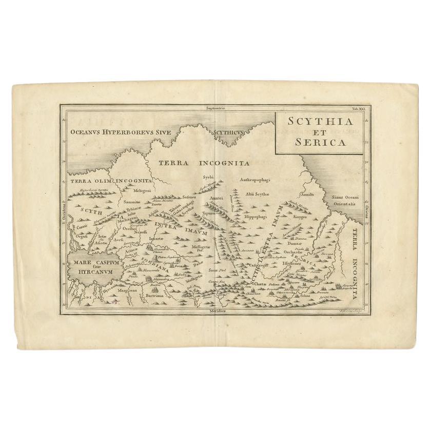
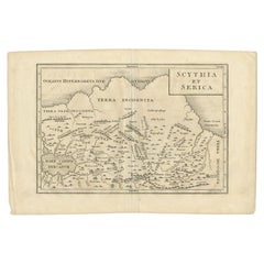
Antique map titled 'Ligures, Taurini, etc.' Miniature map of northwest Italy. From the pocket atlas 'Introductionis in Universam Geographiam tam Veterem quam novam .. Acessit P. Bertii (Bertius) Brevarium Orbis Terrarum', by Ph. Cluverius (Cluver). Artists and Engravers: Petrus Bertius (also Peter Bertius; (Dutch) Pieter de Bert) (14 November 1565 ? 13 October 1629) was a Flemish theologian, historian, geographer and cartographer. Philipp Cluver (1580 - 1622), early modern German geographer and historian.
Artist: Petrus Bertius (also Peter Bertius; (Dutch) Pieter de Bert) (14 November 1565 ? 13 October 1629) was a Flemish theologian, historian, geographer and cartographer. Philipp Cluver (1580 - 1622), early modern German geographer and historian.
Condition: Good, given age. Original folds as issued. General age-related toning and/or occasional minor defects from handling. Please study image carefully.
Date: 1685
Overall size: 14 x 13 cm.
Image size: 0.001 x 12.3 x 12 cm.
Antique prints have long been appreciated for both their aesthetic and investment value. They were the product of engraved, etched or lithographed plates. These plates were handmade out of wood or metal, which required an incredible level of skill, patience and craftsmanship. Whether you have a house with Victorian furniture or more contemporary decor an old engraving can enhance your living space. We offer a wide range of authentic antique prints for any budget.
- Dimensions:Height: 5.12 in (13 cm)Width: 5.52 in (14 cm)Depth: 0 in (0.01 mm)
- Materials and Techniques:
- Period:
- Date of Manufacture:1685
- Condition:
- Seller Location:Langweer, NL
- Reference Number:
About the Seller
5.0
Platinum Seller
These expertly vetted sellers are 1stDibs' most experienced sellers and are rated highest by our customers.
Established in 2009
1stDibs seller since 2017
1,965 sales on 1stDibs
Typical response time: <1 hour
- ShippingRetrieving quote...Ships From: Langweer, Netherlands
- Return PolicyA return for this item may be initiated within 14 days of delivery.
More From This SellerView All
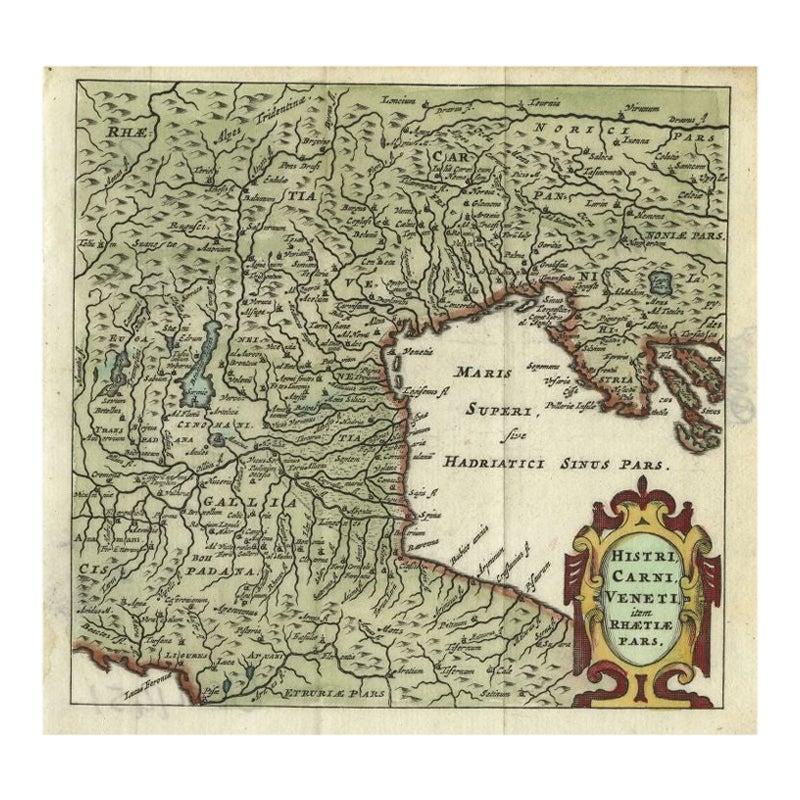
- Antique Map of Northern Italy by Cluver, 1685Located in Langweer, NLAntique map titled 'Histri, Carni, Veneti item Rhaetiae Pars.' Charming miniature map of northern Italy with the Adriatic or upper sea, now called the Gulf of Venice, from the pocket...Category
Antique 17th Century Maps
MaterialsPaper
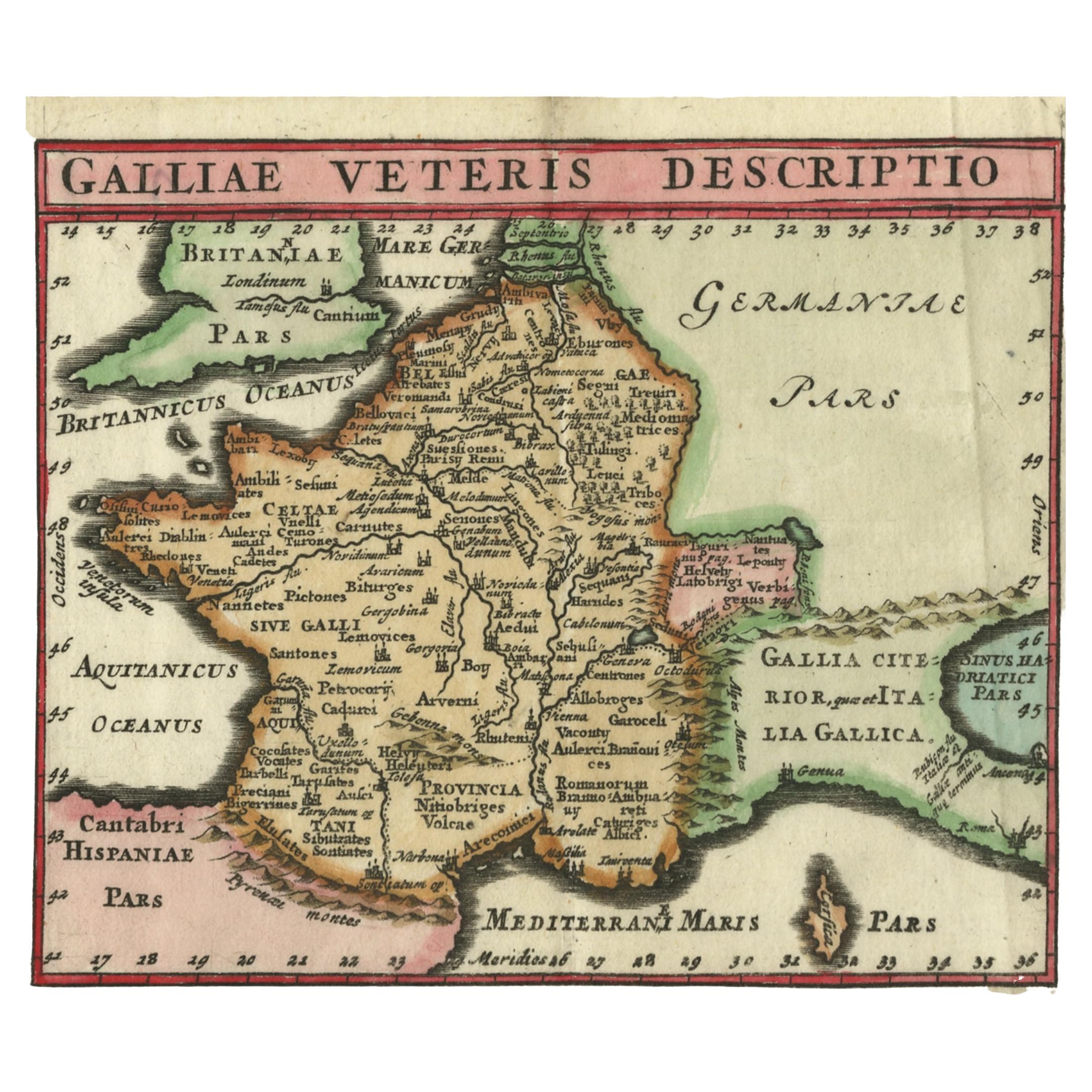
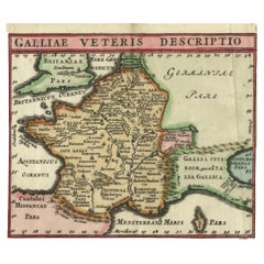
- Antique Map of France by Cluver, 1685Located in Langweer, NLAntique map titled 'Galliae Veteris Descriptio.' Charming miniature map of France from the pocket atlas 'Introductionis in Universam Geographiam tam Veterem quam novam .. Acessit P. ...Category
Antique 17th Century Maps
MaterialsPaper
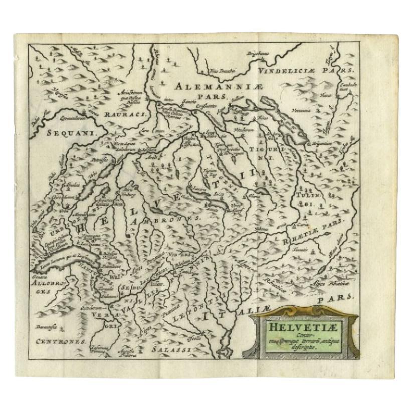
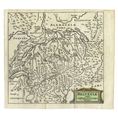
- Antique Map of Switzerland by Cluver, 1685Located in Langweer, NLAntique map titled 'Helvetiae Conterminarumque Terrarii, antiqua descriptio.' Miniature map of Switzerland, from the pocket atlas 'Introductionis in...Category
Antique 17th Century Maps
MaterialsPaper
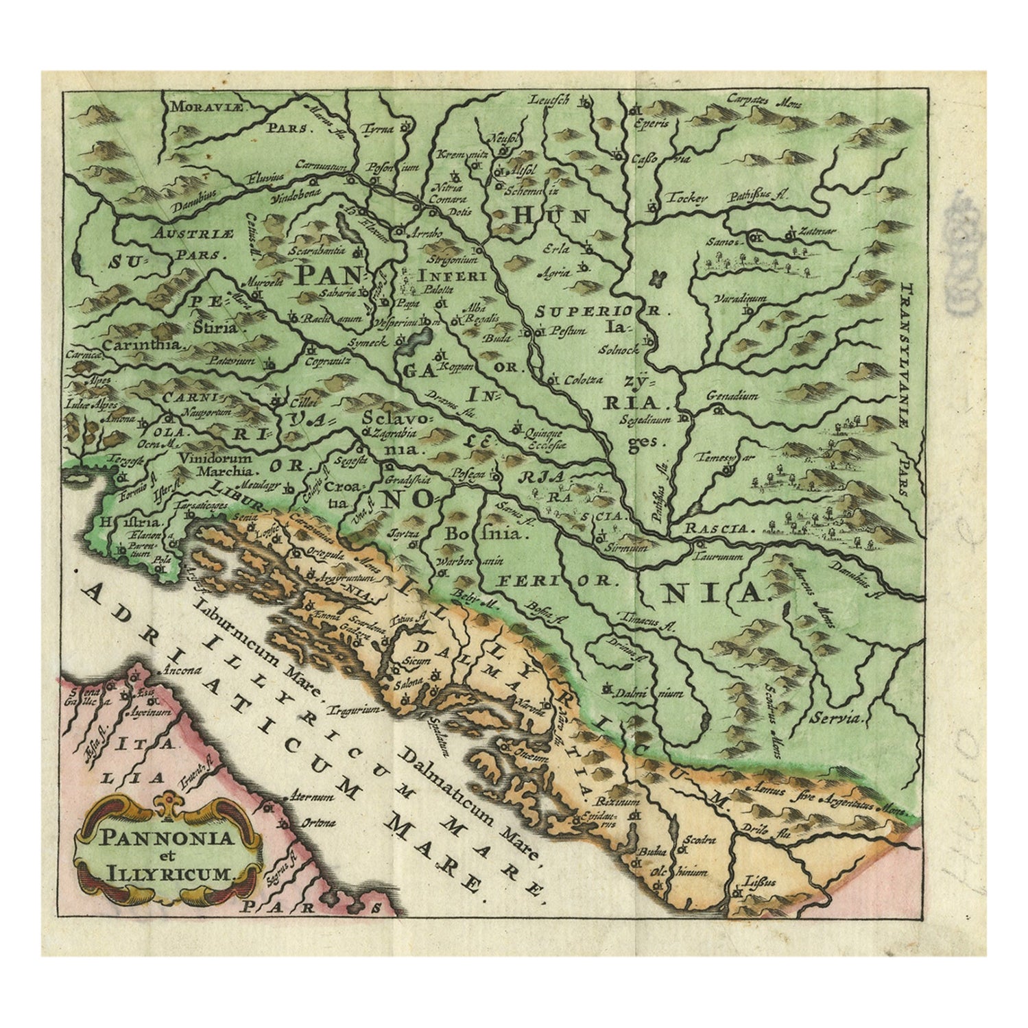
- Antique Map of Pannonia and Illyria by Cluver, 1685Located in Langweer, NLAntique map titled 'Pannonia et Illyricum.' Charming miniature map of Pannonia and Illyria, from the pocket atlas 'Introductionis in Universam Geographiam tam Veterem quam novam .. A...Category
Antique 17th Century Maps
MaterialsPaper
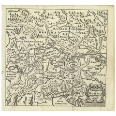
- Antique Map of Southern Germany and Switzerland by Cluver, 1685Located in Langweer, NL"Antique map titled 'Vindeliciae et Norici conterminarunque terrarum antiqua descriptio.' Miniature map of south Germany and Switzerland in Celtic times, From the pocket atlas 'Intro...Category
Antique 17th Century Maps
MaterialsPaper
- Antique Map of the Region Between the Rhine and Elbe River by Cluver, 1685Located in Langweer, NLAntique map titled 'Populorum Germanium inter Rhenum et Albim descriptio, ut inter Caesaris aevum incolurant (…).' Miniature map of the area between the Rhine and the Elbe, Germany. ...Category
Antique 17th Century Maps
MaterialsPaper


You May Also Like
- Northwest Coast and Isle of Man MapLocated in Cheshire, GBGreenville Collins Northwest Coast and Isle of Man. hand coloured chart, encased in an ebonised frame. Dimensions Height 26.5 Inches Width 30 Inches Depth 1 InchesCategory
Early 20th Century British Maps
MaterialsPaper
- Antique Map of Italy by Andriveau-Goujon, 1843By Andriveau-GoujonLocated in New York, NYAntique Map of Italy by Andriveau-Goujon, 1843. Map of Italy in two parts by Andriveau-Goujon for the Library of Prince Carini at Palazzo Carini i...Category
Antique 1840s French Maps
MaterialsLinen, Paper
- Original Antique Map of Italy. C.1780Located in St Annes, LancashireGreat map of Italy Copper-plate engraving Published C.1780 Unframed.Category
Antique Early 1800s English Georgian Maps
MaterialsPaper

- Original Antique Map of Italy. Arrowsmith. 1820Located in St Annes, LancashireGreat map of Italy Drawn under the direction of Arrowsmith Copper-plate engraving Published by Longman, Hurst, Rees, Orme and Brown, 1820 Unframed.Category
Antique 1820s English Maps
MaterialsPaper
- 17th Century Map of Cumberland County in Northwest England Printed by John SpeedBy John SpeedLocated in Middleburg, VARare extremely early map of the county of Cumberland in the Northwest of England. Printed by John Speed, hand colored. Excellent condition. English. Dated...Category
Antique Early 17th Century English Maps
MaterialsPaper
- 1861 Topographical Map of the District of Columbia, by Boschke, Antique MapLocated in Colorado Springs, COPresented is an original map of Albert Boschke's extremely sought-after "Topographical Map of the District of Columbia Surveyed in the Years 1856 ...Category
Antique 1860s American Historical Memorabilia
MaterialsPaper


Recently Viewed
View AllMore Ways To Browse
Early Modern
Northwest Furniture
Antique Furniture Northwest
A Tam
Ships Log
17th Century Scottish Furniture
17th Century Scottish
Antique Malaysia
Malaysian Antique
Map Tapestry
World Map Copper
18th Century Globe Of The World
American Empire Antiques
Large Antique Compass
Egyptian Authentic Furniture
Sweden Antique Map
Joan Blaeu
Map Of Vienna