Items Similar to Antique Map of Seine et Oise 'France' by V. Levasseur, 1854


Want more images or videos?
Request additional images or videos from the seller
1 of 5
Antique Map of Seine et Oise 'France' by V. Levasseur, 1854
About the Item
Antique map titled 'Dépt. de Seine et Oise'. Map of the French department of Seine-et-Oise. Centred on Versailles, its administrative centre, Seine-et-Oise extends from Espernon to Melun and from Pontoise to Etampes. Paris figures prominently in the right hand section of the map. Also shows the city walls surrounding Paris as well as the ring of fortifications completed in 1848. The embastillement of Paris was perhaps the most extravagant waste of resources of the July Monarchy. The whole is surrounded by elaborate decorative engravings designed to illustrate the agricultural and cultural wealth of the region. There is a short textual history of Seine-et-Oise on both the left and right sides of the map. This map originates from ‘Atlas National de la France Illustré’. Published by A. Combette, Paris, 1854.
- Creator:Victor Levasseur (Artist)
- Dimensions:Height: 13.98 in (35.5 cm)Width: 20.67 in (52.5 cm)Depth: 0.02 in (0.5 mm)
- Materials and Techniques:
- Period:
- Date of Manufacture:1854
- Condition:General age-related toning. Please study image carefully.
- Seller Location:Langweer, NL
- Reference Number:

Victor Levasseur
Victor Jules Levasseur (1795–1862) was a French cartographer widely known for his distinctive decorative style. He produced numerous maps more admired for the artistic content of the scenes and data surrounding the map than for the detail of the map. Victor Levasseur was born in 1795 in France. Little is known about his early life and education, but he emerged as one of the most prominent French cartographers of the 19th century. Levasseur lived during a time of significant political and geographical changes in France and Europe, which greatly influenced his work as a mapmaker.
About the Seller
5.0
Platinum Seller
These expertly vetted sellers are 1stDibs' most experienced sellers and are rated highest by our customers.
Established in 2009
1stDibs seller since 2017
1,967 sales on 1stDibs
Typical response time: <1 hour
- ShippingRetrieving quote...Ships From: Langweer, Netherlands
- Return PolicyA return for this item may be initiated within 14 days of delivery.
More From This SellerView All
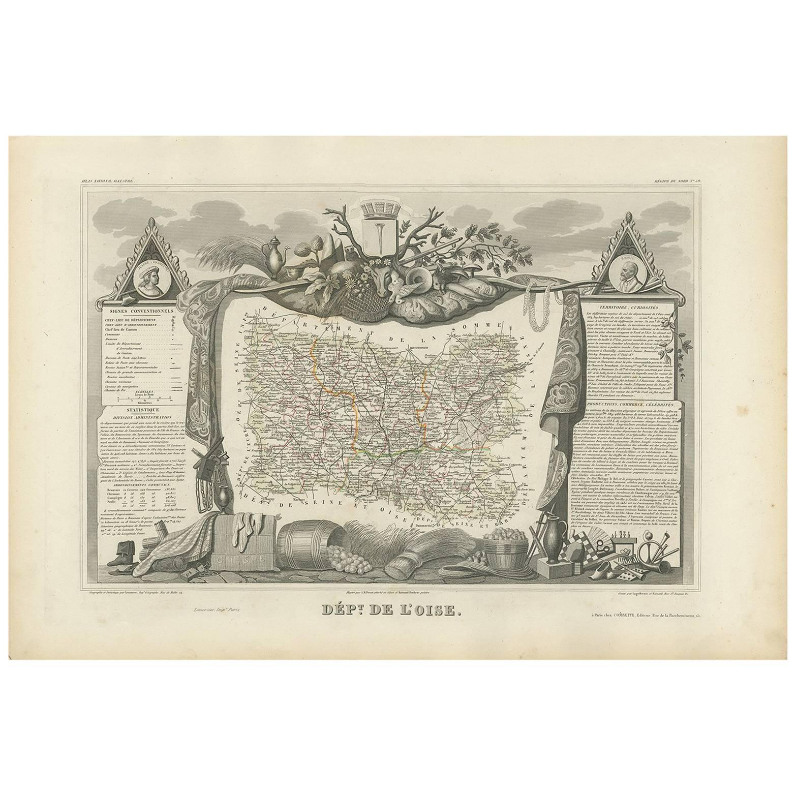
- Antique Map of Oise ‘France’ by V. Levasseur, 1854By Victor LevasseurLocated in Langweer, NLAntique map titled 'Dépt. de l'Oise'. Map of the French department of Oise, France. The map is surrounded by elaborate decorative engravings designed to illustrate both the natural b...Category
Antique Mid-19th Century Maps
MaterialsPaper
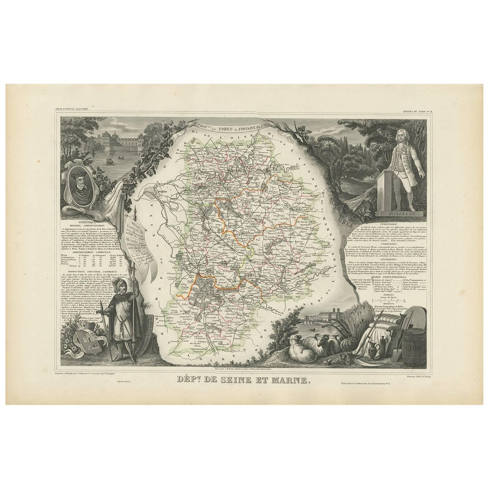
- Antique Map of Seine et Marne 'France' by V. Levasseur, 1854By Victor LevasseurLocated in Langweer, NLAntique map titled 'Dépt. de Seine et Marne'. Map of the French department of Seine Et Marne, France. This region produces a wide variety of wines and h...Category
Antique Mid-19th Century Maps
MaterialsPaper
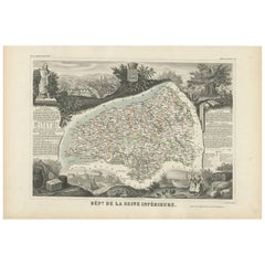
- Antique Map of Seine Inférieure, France by V. Levasseur, 1854By Victor LevasseurLocated in Langweer, NLAntique map titled 'Dépt. de la Seine Inférieure'. Map of the French department of Seine Inferieure, France. Centered around its capital of Rouen, this area is known for its producti...Category
Antique Mid-19th Century Maps
MaterialsPaper
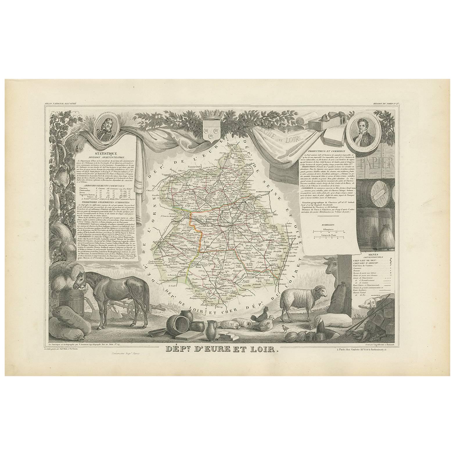
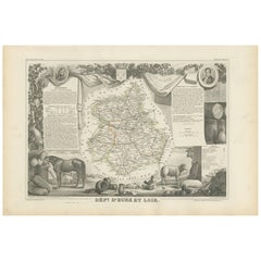
- Antique Map of Eure Et Loir ‘France’ by v. Levasseur, 1854By Victor LevasseurLocated in Langweer, NLAntique map titled 'Dépt. d'Eure et Loir'. Map of the French department of Eure Et Loir, France. This area is home to the famous Chartres Cathedral....Category
Antique Mid-19th Century Maps
MaterialsPaper
- Antique Map of Jura ‘France’ by V. Levasseur, 1854By Victor LevasseurLocated in Langweer, NLAntique map titled 'Dépt. du Jura'. Map of the French department Jura, France. The Jura wines are very distinctive and unusual, such as Vin Jaune, which is made by a similar process ...Category
Antique Mid-19th Century Maps
MaterialsPaper
- Antique Map of Landes ‘France’ by V. Levasseur, 1854By Victor LevasseurLocated in Langweer, NLAntique map titled 'Dépt. des Landes'. Map of the French department Landes, France. This area is known for its production of Chalossais, a white cow cheese with a gentle, acidic edge...Category
Antique Mid-19th Century Maps
MaterialsPaper


You May Also Like
- Original Antique Map of France, Arrowsmith, 1820Located in St Annes, LancashireGreat map of France Drawn under the direction of Arrowsmith. Copper-plate engraving. Published by Longman, Hurst, Rees, Orme and Brown, 1820 Unframed.Category
Antique 1820s English Maps
MaterialsPaper
- Antique Map of Italy by Andriveau-Goujon, 1843By Andriveau-GoujonLocated in New York, NYAntique Map of Italy by Andriveau-Goujon, 1843. Map of Italy in two parts by Andriveau-Goujon for the Library of Prince Carini at Palazzo Carini i...Category
Antique 1840s French Maps
MaterialsLinen, Paper
- Antique Map of Principality of MonacoBy Antonio Vallardi EditoreLocated in Alessandria, PiemonteST/619 - "Old Geographical Atlas of Italy - Topographic map of ex-Principality of Monaco" - ediz Vallardi - Milano - A somewhat special edition ---Category
Antique Late 19th Century Italian Other Prints
MaterialsPaper
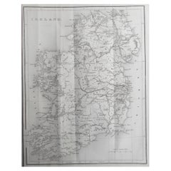
- Original Antique Map of Ireland by Hughes. C.1850Located in St Annes, LancashireGreat map of Ireland Engraved by W.Hughes Published by Virtue, C.1850 Unframed.Category
Antique 1850s Scottish Other Maps
MaterialsPaper
- Original Antique Map of Scotland by Becker. C.1850Located in St Annes, LancashireGreat map of Scotland Engraved by F.P Becker Published by Virtue, C.1850 Unframed.Category
Antique 1850s Scottish Other Maps
MaterialsPaper
- Original Antique Map of Russia By Arrowsmith. 1820Located in St Annes, LancashireGreat map of Russia Drawn under the direction of Arrowsmith Copper-plate engraving Published by Longman, Hurst, Rees, Orme and Brown, 1820 Unframed.Category
Antique 1820s English Maps
MaterialsPaper


Recently Viewed
View AllMore Ways To Browse
Antique Wall Maps
Antique Map Of Paris France
Antique Maps Of Paris France
French Wall Map
Wall Map Of France
Paris City Maps
Agriculture Map
Antique V Rings
Atlas Ring
Versaille Engraving
Antique Paris Wall Map
Victor Levasseur On Sale
Melun Paris
Buys Antique Furniture
Original World Map
Antique World Maps
World Map Antique
World Maps Antique