Items Similar to Antique Uncommon Dutch Map of Ancient Israel, c.1730


Want more images or videos?
Request additional images or videos from the seller
1 of 6
Antique Uncommon Dutch Map of Ancient Israel, c.1730
About the Item
Antique map titled 'Ontwerp en Erfdeeling van't Land Kanaan, volgens het gezicht van Ezechiel.' Uncommon map of ancient Israel. This map shows Israel from Hethelon in the north to Kades, just south of the Dead Sea. Divided into the areas controlled by the Twelve Tribes of Israel, from the north these are Dan, Aser, Naphtali, Manasse, Ephraim, Ruben, Juda, Benjamin, Simeon, Issachar, Zebulon and Gad. Shows several important cities including Jerusalem, Gaza, Cezarea (Caesarea), Damascus, Tyrus (Tyre), Joppe (Jaffa near modern Tel Aviv), etc. The right side of the map is dedicated to Old Testament quotations, mostly drawn from the Book of Ezekiel, describing the region.
Source unknown, to be determined.
Artists and Engravers: Anonymous.
Condition: Good, given age. A few minor crinkles. General age-related toning and/or occasional minor defects from handling. Please study image carefully.
Date: c.1730
Overall size: 25 x 40.7 cm.
Image size: 18.5 x 35 cm.
We sell original antique maps to collectors, historians, educators and interior decorators all over the world. Our collection includes a wide range of authentic antique maps from the 16th to the 20th centuries. Buying and collecting antique maps is a tradition that goes back hundreds of years. Antique maps have proved a richly rewarding investment over the past decade, thanks to a growing appreciation of their unique historical appeal. Today the decorative qualities of antique maps are widely recognized by interior designers who appreciate their beauty and design flexibility. Depending on the individual map, presentation, and context, a rare or antique map can be modern, traditional, abstract, figurative, serious or whimsical. We offer a wide range of authentic antique maps for any budget.
- Dimensions:Height: 16.03 in (40.7 cm)Width: 9.85 in (25 cm)Depth: 0 in (0.01 mm)
- Materials and Techniques:
- Period:
- Date of Manufacture:circa 1730
- Condition:
- Seller Location:Langweer, NL
- Reference Number:
About the Seller
5.0
Platinum Seller
These expertly vetted sellers are 1stDibs' most experienced sellers and are rated highest by our customers.
Established in 2009
1stDibs seller since 2017
1,974 sales on 1stDibs
Typical response time: <1 hour
- ShippingRetrieving quote...Ships From: Langweer, Netherlands
- Return PolicyA return for this item may be initiated within 14 days of delivery.
More From This SellerView All
- Beautiful Antique Map of the Province of Noord-Holland, the Netherlands, Ca.1730Located in Langweer, NLAntique map titled 'Kennemaria et Westfrisia vulgo et vernaculé Noord-Holland'. Beautiful original antique map of the province of Noord-Holland, the Netherlands. Two large elaborat...Category
Antique 1730s Maps
MaterialsPaper
- Antique Map of France by Mortier 'c.1730'Located in Langweer, NLAntique map titled 'Galliae Antiquae Tabula'. Original antique map of France in ancient times. Published by P. Mortier, circa 1730.Category
Antique Mid-18th Century Maps
MaterialsPaper
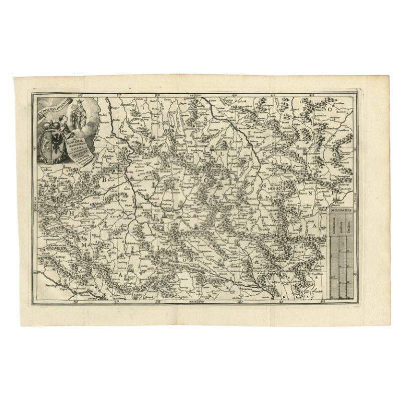
- Antique Uncommon Map of Bohemia, Moravia and Silesia, 1699Located in Langweer, NLAntique map titled 'B. V. Boleslaviensis in Bohemia, Moravia et Silesia (..).' Detailed uncommon map of the Bohemia, Moravia and Silesia. Source unknown, to be determined. Artists...Category
Antique 17th Century Maps
MaterialsPaper
- Antique Map of Denmark by Covens & Mortier, 1730By Covens & MortierLocated in Langweer, NLAntique Map of Denmark from: 'Atlas Nouveau ... Par Guillaume de l'Isle' Amsterdam, Covens & Mortier, 1730.Category
Antique Mid-18th Century Maps
MaterialsPaper
- Antique Map of Sweden by Homann, 'circa 1730'Located in Langweer, NLAntique map titled 'Nova Tabula Scaniae (..)'. Attractive map showing the historical provinces of Sweden: Schonen with Malmö, Blekinge with Karlskrona and the south part of Halland. ...Category
Antique Mid-18th Century Maps
MaterialsPaper
- Decorative Original Antique Map of Southern Germany, c.1730Located in Langweer, NL"Antique map titled 'The South West Part of Germany. Containing ye Dominions of the Archbishops and Electors of Mentz Y Treves, and of ye Elec. Palatine of ye Rhine; with Franconia, ...Category
Antique 18th Century Maps
MaterialsPaper


You May Also Like
- Original Antique Map of Ancient Greece, Achaia, Corinth, 1786Located in St Annes, LancashireGreat map of Ancient Greece. Showing the region of Thessaly, including Mount Olympus Drawn by J.D. Barbie Du Bocage Copper plate engraving by P.F Tardieu Original hand color...Category
Antique 1780s French Other Maps
MaterialsPaper
- Original Antique Map of Ancient Greece- Boeotia, Thebes, 1787Located in St Annes, LancashireGreat map of Ancient Greece. Showing the region of Boeotia, including Thebes Drawn by J.D. Barbie Du Bocage Copper plate engraving by P.F T...Category
Antique 1780s French Other Maps
MaterialsPaper
- Antique Map of Principality of MonacoBy Antonio Vallardi EditoreLocated in Alessandria, PiemonteST/619 - "Old Geographical Atlas of Italy - Topographic map of ex-Principality of Monaco" - ediz Vallardi - Milano - A somewhat special edition ---Category
Antique Late 19th Century Italian Other Prints
MaterialsPaper
- Original Antique Map of India. C.1780Located in St Annes, LancashireGreat map of India Copper-plate engraving Published C.1780 Three small worm holes to right side of map and one bottom left corner Unframed.Category
Antique Early 1800s English Georgian Maps
MaterialsPaper

- Original Antique Map of Asia. C.1780Located in St Annes, LancashireGreat map of Asia Copper-plate engraving Published C.1780 Two small worm holes to right side of map Unframed.Category
Antique Early 1800s English Georgian Maps
MaterialsPaper

- Original Antique Map of Italy. C.1780Located in St Annes, LancashireGreat map of Italy Copper-plate engraving Published C.1780 Unframed.Category
Antique Early 1800s English Georgian Maps
MaterialsPaper


Recently Viewed
View AllMore Ways To Browse
18th C Dutch
Israeli Artist Furniture
Antique Israel
Israel Antique
Israeli Antique
Ancient World Map
Ancient Israel
Antique Furniture Israel
Damascus Furniture
Antique Damascus
Used Tyre Furniture
Antique Tyre
Antique Map Israel
Antique Map Of Israel
Antique Maps Of Israel
Israel Map
Map Of Israel
Antique Map Of Jerusalem