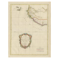
Items Similar to The Cape Verde Islands Coast Antique Engraving by Van Schley, 1747


Want more images or videos?
Request additional images or videos from the seller
1 of 5
The Cape Verde Islands Coast Antique Engraving by Van Schley, 1747
About the Item
Antique map titled ‘Carte Exacte de la cote du Cap Verd (..) - Naauwkeurige Kaart van de Kust van Kabo Verde (..)'. Original antique map of the coast of the Cape Verde Islands. This map originates from 'Historische beschryving der Reizen (..)' published by P. de Hondt, 1747.
Artists and Engravers: Jakob van der Schley (1715-1779) was a Dutch draughtsman and engraver, who studied under Bernard Picart.
We sell original antique maps to collectors, historians, educators and interior decorators all over the world. Our collection includes a wide range of authentic antique maps from the 16th to the 20th centuries. Buying and collecting antique maps is a tradition that goes back hundreds of years. Antique maps have proved a richly rewarding investment over the past decade, thanks to a growing appreciation of their unique historical appeal. Today the decorative qualities of antique maps are widely recognized by interior designers who appreciate their beauty and design flexibility. Depending on the individual map, presentation, and context, a rare or antique map can be modern, traditional, abstract, figurative, serious or whimsical. We offer a wide range of authentic antique maps for any budget.
- Dimensions:Height: 10.01 in (25.4 cm)Width: 7.52 in (19.1 cm)Depth: 0 in (0.01 mm)
- Materials and Techniques:Paper,Engraved
- Period:
- Date of Manufacture:1747
- Condition:Condition: Good, general age-related toning. Original plate mark visible. Please study image carefully.
- Seller Location:Langweer, NL
- Reference Number:
About the Seller
5.0
Platinum Seller
These expertly vetted sellers are 1stDibs' most experienced sellers and are rated highest by our customers.
Established in 2009
1stDibs seller since 2017
1,960 sales on 1stDibs
Typical response time: <1 hour
- ShippingRetrieving quote...Ships From: Langweer, Netherlands
- Return PolicyA return for this item may be initiated within 14 days of delivery.
More From This SellerView All
- Antique Map of the Coast of Cape Verde by J. Van Der Schley, circa 1750Located in Langweer, NLAn early map of what is now the coast of the capital city of Dakar, Senegal. What is now a dense, bustling city was at this time a uninhabited coast. Shows the overall contours of th...Category
Antique Mid-18th Century Maps
MaterialsPaper
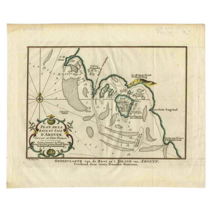
- Antique Map of the Bay and Island of Arguin by Van Schley, 1747Located in Langweer, NLAntique map titled ?Plan de la Baye et Isle d'Arguim (..) - Oppervlakte van de Baai en 't Eiland van Arguin (..)'. Original antique map of the bay and the island of Arguin. This map ...Category
Antique 18th Century Maps
MaterialsPaper
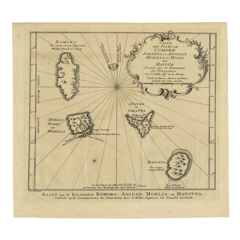
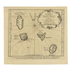
- Comore Island Original Antique Engraving by Van Schley, 1749Located in Langweer, NLAntique map titled 'Carte des Isles de Comore Johanna ou Anouan Mohilla ou Moaly et Mayote (..) - Kaart van de Eilanden Komoro, Anjuan, Moelia, en Mayotta (..)'. Copper engraving of ...Category
Antique 18th Century Maps
MaterialsPaper
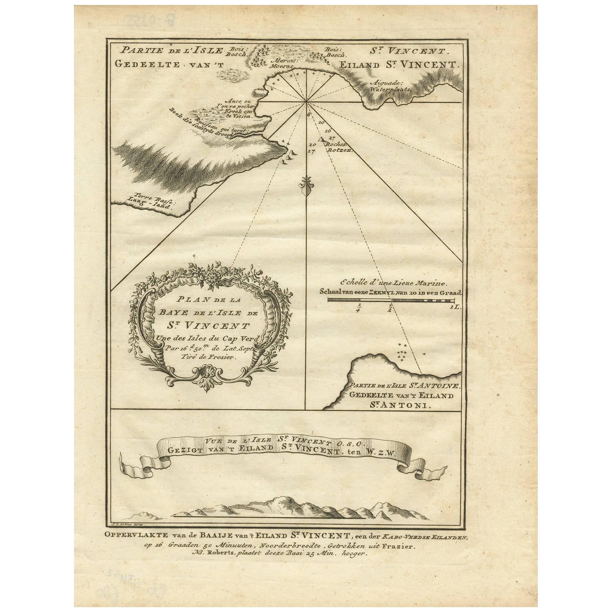
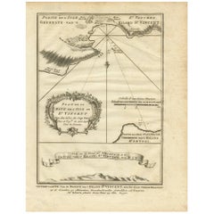
- Antique Print of the Bay of the Island of St. Vincent by Van Schley (1747)Located in Langweer, NLAntique print titled 'Oppervlakte van de Baaije van 't Eiland St. Vincent (..)'. View of the Bay of the Island of St. Vincent, one of the Capeverdian Islands. Originates from a Dutch...Category
Antique Mid-18th Century Maps
MaterialsPaper
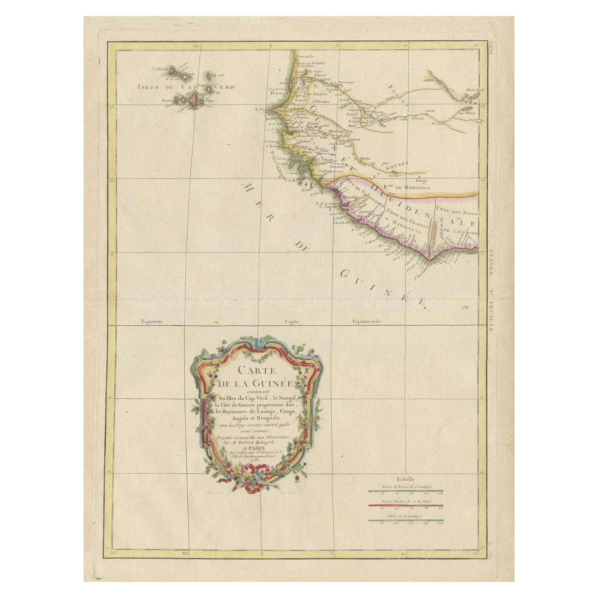
- Antique Map of the Coast of Guinea and the Cape Verde IslandsLocated in Langweer, NLAntique map titled 'Carte de la Guinée (..)'. This map was originally part of a 2 sheet larger map of Eastern Africa, showing the Cape Verde Islands and Senegal. This map originates ...Category
Antique Late 18th Century Maps
MaterialsPaper
- Antique Map of the West African Coast and the Cape Verde Islands, c.1680Located in Langweer, NLAntique map Africa titled 'Isles du Cap Verd Coste et Pays des Negres'. Antique map of the coast of Africa and the Cape Verde islands. Artists a...Category
Antique 17th Century Maps
MaterialsPaper


You May Also Like
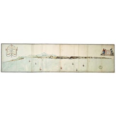
- Very Large Hand-Drawn View of St Iago Cape Verde, by Frederici, 1783Located in Amsterdam, NLJohann Christian Friderici [= Frederici] (Heldburg 1766 - Cape Town 1804) Prospect van het eyland, en de rheede van St. Iago. Geteekend van Johann Christian Friderici / Verbeelding van de inwoonders op St Iago (View of the island, and the roadstead of St. Iago. Drawn by Johann Christian Friderci / Depiction of the inhabitants on St Iago) ?Porto Praia, Cape Verde...Category
Antique Late 18th Century Cape Verdean Dutch Colonial Maps
MaterialsPaper
- Island Whimsy Designing a Paradise by the SeaBy Rizzoli International PublicationsLocated in New York, NYAuthor Celerie Kemble A house by the sea should be a house of dreams. Where windows and doors are thrown open to the ocean, and gusts of cool, salty air turn us all into kids again--buoyant and joyful. Spending childhood days on the beach and in the magical, romantic chaos of her family's rambling house internationally renowned interior designer Celerie Kemble has a deep-rooted connection to the sun and surf. However, in the summer of 2004, Kemble laid eyes on a wild swath of jungle in the Dominican Republic next to minty-blue water and an endless stretch of golden sand, she fell madly in love. Over many years, she designed a home away from home there, an island retreat--a clubhouse and a grouping of family homes and guesthouses--suffused with light and air, full of indoor and outdoor rooms for relaxation. In her latest book, Island Whimsy, Kemble recounts the deeply personal and creative journey of designing Playa Grande and bringing this labor of love to life. The chapters of this book are organized around the different ways Kemble sought to braid her family's story into the larger landscape of Playa Grande and to provide inspiration, joy, and respite to all who come. "Fantasy" looks at the way she used whimsical, dreamlike elements--from the latticework cabanas by the pool to the lamb statues...Category
21st Century and Contemporary North American Books
MaterialsPaper
- Red Sea, The Saudi CoastBy Assouline PublishingLocated in NEW YORK, NYBordering the coastlines of eight countries, the Red Sea is a melting pot of civilizations, faiths and hopes. With unique coral reefs and diverse underwater life...Category
2010s American Books
MaterialsLinen
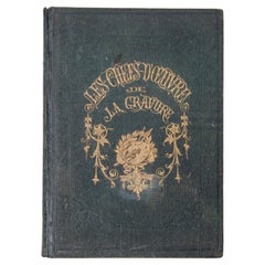
- "The Masterpieces of Engraving"By Eugene Maxime ValléeLocated in Alessandria, PiemonteO/7821 - interesting French book that I saved from ruin: they are usually dismembered to make prints to sell individually. This one is intact, with its 24 printed plates. Nice to ...Category
Antique Mid-19th Century French Other Books
MaterialsPaper
- “The Restaurant of the House of Representatives” Engraving by Harper's WeeklyLocated in Colorado Springs, COThis original wood engraving is titled “The Restaurant of the House of Representatives, Washington, DC.” It was published as a double-page image, in the August 12, 1893 issue of the famous 19th century newspaper Harper’s Weekly. The print was illustrated by Charles Stanley Reinhardt. The House Restaurant, a unique part of life in the Capitol, has been in the same location since the 1857 Capitol Expansion. Congressional members’ busy work schedule made the availability of food on site a necessity. But the restaurant also served as an informal meeting spot for members to continue conversations and deal making. This 1893 print illustrates the convivial atmosphere. Details including elegantly dressed tables...Category
Antique 1890s American Prints
MaterialsPaper
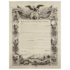
- 1864 Abraham Lincoln's Emancipation Proclamation, Antique Engraving by W RobertsLocated in Colorado Springs, COPresented is a Proclamation of Emancipation wood engraving by W. Roberts. The engraving was published in 1864, just one year after President Abraham Lincoln signed the original Proclamation. W. Roberts was the artist and engraver and Corydon Alexis Alvord was the printer. The engraving was published by R. A Dimmick, in New York, 1864. The text of the Proclamation is set in a variety of typefaces, which is encased in a pictorial border. The border is decorated with a portrait of Abraham Lincoln and seven other vignettes, including the horrors of slavery at left, the bombardment of Fort Sumter at bottom, and scenes from a prosperous and united nation at right. On September 22, 1862, five days after the Union victory at the Battle of Antietam, Lincoln issued a preliminary decree stating that, unless the rebellious states returned to the Union by January 1, freedom would be granted to slaves within those states. No Confederate states took the offer, and on January 1, 1863 Lincoln presented the Emancipation Proclamation...Category
Antique 1860s American Historical Memorabilia
MaterialsPaper


Recently Viewed
View AllMore Ways To Browse
Cape Beige
Antique Capes
Cape Antique Furniture
Cape Dutch Furniture
Cape Verde
Cape Dutch Antique Furniture
Antique Nautical Map
Antique Nautical Maps
Map Of Arabia
Antique Stand Up Scale
Civil War Map
Antique Furniture Cyprus
Antique Linen Map
Antique Nautical Charts
British Isles Antique Map
Georgia Map
Map Of West Indies
Scottish Coat Of Arms