Items Similar to Dutch Map and City Plan of La Roche-sur-Foron, France, 17th Century Hand Colored


Want more images or videos?
Request additional images or videos from the seller
1 of 9
Dutch Map and City Plan of La Roche-sur-Foron, France, 17th Century Hand Colored
About the Item
"Rupes Allobrogum vulgo La Roche" by Dutch engraver Coenraet Decker (1650-1685) is from the atlas Theatrum Statuum Regiae Celestudinis Sabaudiae Ducis, published in 1682. This richly hand colored engraving represents a bird's-eye view of the city plan of La Roche-sur-Foron, originally presented in Johannes Blaeu's (1599-1673) Theatrum Civitatum et Admirandorum Italiae (Town Book of Italy), depicting city views of Italy's Savoy and Piedmont regions. The town of La Roche was, at the time this view was created, a part of Italy, but the Savoy region was annexed by France in 1792.
The double-page extensively colored engraving's title is displayed on flowing ornamental streamers, as would be found waving from an ancient knight's lance. Putti flank a colorful coat of arms. It is presented in a silver frame with a hand colored pale green French mat with a cranberry-colored highlight band. There is a vertical center fold, as issued. The map is in excellent condition. There are small abrasions and chips to the frame.
Provenance: Thomas J. Perkins (1932-2016), San Francisco, and Belvedere, CA, was the Co-Founder Kleiner Perkins & Byers Venture Capital and often referred to as the father of Silicon Valley. He was on the Board of Directors of Hewlett-Packard, Genentech, Compaq, Applied Materials, Philips Electronics, Corning Glass and News Corp. and served as chairman of Tandem Computers and Genentech.
- Creator:Coenraet Decker (Artist)
- Dimensions:Height: 27.75 in (70.49 cm)Width: 32.5 in (82.55 cm)Depth: 0.07 in (1.78 mm)
- Materials and Techniques:Paper,Engraved
- Place of Origin:
- Period:Late 17th Century
- Date of Manufacture:1682
- Condition:Wear consistent with age and use.
- Seller Location:Alamo, CA
- Reference Number:
About the Seller
5.0
Vetted Seller
These experienced sellers undergo a comprehensive evaluation by our team of in-house experts.
1stDibs seller since 2020
12 sales on 1stDibs
- ShippingRetrieving quote...Ships From: Alamo, CA
- Return PolicyA return for this item may be initiated within 7 days of delivery.
More From This SellerView All
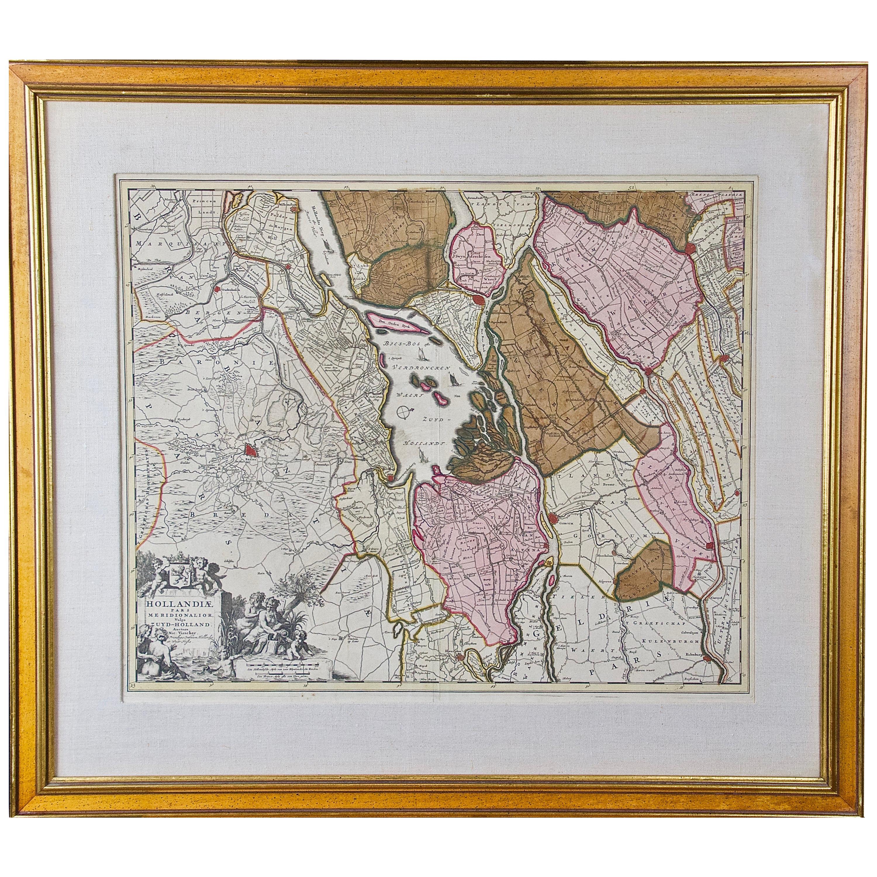
- Hand Colored 17th Century Visscher Map "Hollandiae" Southern HollandBy Nicolaes Visscher IILocated in Alamo, CAA hand colored 17th century map of the southern portions of Holland by Nicolaus (Nicolas) Visscher II entitled "Hollandiae pars Meridionalis, vulgo Zuyd-Holland", published in Amsterdam in 1678. The map shows the region between Breda, Heusden, Gornichem, Gouda, Dordrecht, and Willemstad. It includes a decorative cartouche in the lower left corner. The map is presented in an attractive maple colored wood frame with gold trim and a fabric mat. The Visscher family were one of the great cartographic families of the 17th century. Begun by Claes Jansz Visscher...Category
Antique Early 18th Century Dutch Maps
MaterialsPaper
- Northern Scotland: A 17th Century Hand-colored Map by MercatorBy Gerard MercatorLocated in Alamo, CAThis is a framed hand-colored 17th century map of Northern Scotland by Gerard Mercator entitled "Scotiae pars Septentrionalis", published in Amsterdam in 1636. It is a highly detailed map of the northern part of Scotland, with the northwest Highlands and the cities Inverness and Aberdeen, as well as the Orkney Islands and the Hebrides. There is a decorative title cartouche in the upper left corner. The map is presented in an antiqued brown wood...Category
Antique 1630s Dutch Maps
MaterialsPaper
- "Africa Vetus": a 17th Century Hand-Colored Map by SansonBy Nicolas SansonLocated in Alamo, CAThis original hand-colored copperplate engraved map of Africa entitled "Africa Vetus, Nicolai Sanson Christianiss Galliar Regis Geographi" was originally created by Nicholas Sanson d...Category
Antique Late 17th Century French Maps
MaterialsPaper
- 17th Century Hand-Colored Map of Southeastern England by Mercator and HondiusBy Gerard MercatorLocated in Alamo, CAA 17th century copperplate hand-colored map entitled "The Sixt Table of England" by Gerard Mercator and Jodocus Hondius, published in Amsterdam in 1635 in 'Cosmographicall Descriptio...Category
Antique Mid-17th Century Dutch Maps
MaterialsPaper
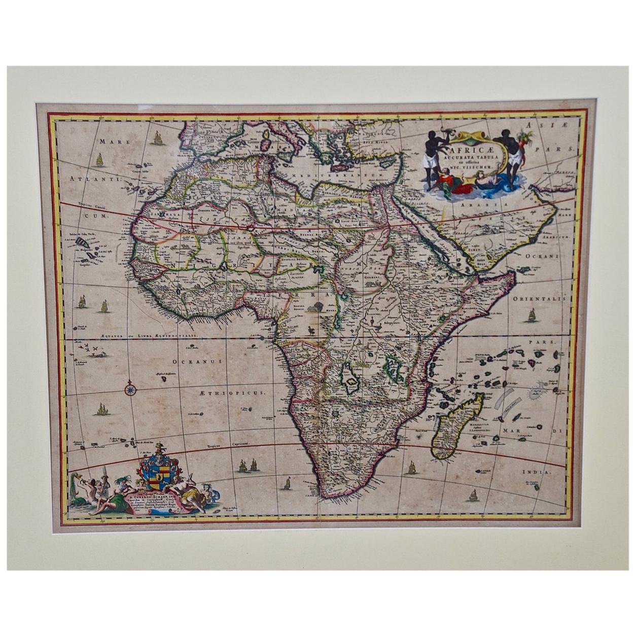
- "Africae Accurata", a Hand-Colored 17th Century Map of Africa by VisscherBy Nicolaes Visscher IILocated in Alamo, CAAn 18th century hand-colored map of Africa entitled "Africae Accurata Tabula ex officina" by Nicolaes Visscher, published in Amsterdam in 1680. This beautiful, colorful and detailed map is embellished by eleven sailing ships, a whale, flying fish and multiple land animals. It includes the Mediterranean Sea and adjacent portions of Portugal, Spain, Italy, Greece and Asia Minor. The map perpetuates several long-standing errors, including the origin of the Nile River from two imaginary lakes in southern Africa, which are shown adjacent to the imaginary Lunae Montes (Mountains of the Moon...Category
Antique Late 17th Century Dutch Maps
MaterialsPaper
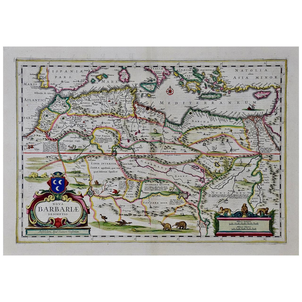
- "Nova Barbariae Descriptio", a 17th Century Hand-Colored Map of North AfricaBy Johannes JanssoniusLocated in Alamo, CAThis original attractive 17th century hand-colored map of North Africa entitled "Nova Barbariae Descriptio" by Johannes Janssonius was published in Paris in 1635. It includes the Med...Category
Antique Mid-17th Century Dutch Maps
MaterialsPaper


You May Also Like
- 17th Century Map of Denmark by French Cartographer Sanson, Dated 1658By Nicolas SansonLocated in Copenhagen, K17th century map of Denmark by French cartographer Sanson. Nicolas Sanson (20 December 1600-7 July 1667) was a French cartographer, termed by some the creator of French geography an...Category
Antique 17th Century French Maps
MaterialsPaper
- 17th Century Topographical Map, French Champagne Region, Epernay, Iohan PeetersLocated in New York, NYFine topographical 17th century map by Iohan Peeters of the towns of Epernay and Lametz in the Champagne Region of North Eastern France. Fabulous period engraving for a Wine Cellar,...Category
Antique 17th Century Dutch Maps
MaterialsPaper
- Old Map of the Dutch City of Megen in Holland, 1916Located in Langweer, NLAntique map Megen titled 'Megen'. Antique map depicting the city of Megen, Noord-Brabant, The Netherlands. Artists and Engravers: Lithograph by J. Smulders & Co, Den Haag. Con...Category
20th Century Maps
MaterialsPaper
- Hand Colored Antique Map of the department of Indre and Loire, FranceBy Victor LevasseurLocated in Langweer, NLAntique map titled 'Dépt. d'Indre et Loire'. Map of the Department de L’Indre et Loire, France. This region is known for its fine wines, agriculture, distilled spirits, and cheese. T...Category
Antique Mid-19th Century Maps
MaterialsPaper
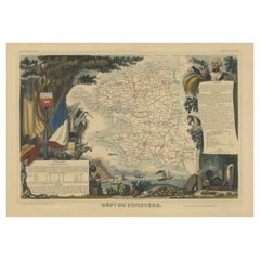
- Hand Colored Antique Map of the department of Finistère, FranceBy Victor LevasseurLocated in Langweer, NLAntique map titled 'Dépt. du Finistère'. Map of the French department of Finistere, Brittany, France. This area of France is known for its cider production and excellent boar hunting...Category
Antique Mid-19th Century Maps
MaterialsPaper
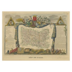
- Hand Colored Antique Map of the Department of Oise, FranceBy Victor LevasseurLocated in Langweer, NLAntique map titled 'Dept. de l'Oise'. Old map of the French department of Oise, France. The map proper is surrounded by elaborate decorative engravings designed to illustrate both th...Category
Antique Mid-19th Century Maps
MaterialsPaper


Recently Viewed
View AllMore Ways To Browse
Colorful Coat
Corning Glass
Antique City Plans
Map Colorful
17th Century Dutch Frame
17th Century Dutch Silver
French 17th Century Silver
Philip Thomas
17th Century Colored Engraving
Dutch Coat Of Arms
Antique Lance
Antique Double Silver Frame
Dutch Green Glass
Cranberry Glass With Silver
Dutch Engraved Glass
Green Italian Glass Bird
Antique Silver Knight
17th Century Italy Map