Items Similar to Old Map of Spain and Portugal, with an Inset Map of the Region of Madrid, 1846


Want more images or videos?
Request additional images or videos from the seller
1 of 5
Old Map of Spain and Portugal, with an Inset Map of the Region of Madrid, 1846
About the Item
Antique map titled 'Kingdom of Spain and Portugal'.
Old map of Spain and Portugal, with an inset map of the region of Madrid. This map originates from 'A New Universal Atlas Containing Maps of the various Empires, Kingdoms, States and Republics Of The World (..) by S.A. Mitchell.
Artists and Engravers: Samuel Augustus Mitchell was an American geographer. Mitchell worked as a teacher before turning to publishing geography textbooks and maps. He became involved in geography after teaching and realizing that there were so many poor quality geographical resources available to teachers. He was in Philadelphia when he founded his company. His son, S. Augustus Mitchell, became owner in 1860. Their publications covered all genres of geography: maps, travel guides, textbooks, and more.
- Dimensions:Height: 13.78 in (35 cm)Width: 17.13 in (43.5 cm)Depth: 0 in (0.02 mm)
- Materials and Techniques:
- Period:
- Date of Manufacture:1846
- Condition:Wear consistent with age and use. Condition: Good, original/contemporary hand coloring. Age-related toning and some wear, mainly in margins. Blank verso, please study image carefully.
- Seller Location:Langweer, NL
- Reference Number:
About the Seller
5.0
Platinum Seller
These expertly vetted sellers are 1stDibs' most experienced sellers and are rated highest by our customers.
Established in 2009
1stDibs seller since 2017
1,959 sales on 1stDibs
Typical response time: <1 hour
- ShippingRetrieving quote...Ships From: Langweer, Netherlands
- Return PolicyA return for this item may be initiated within 14 days of delivery.
More From This SellerView All
- Antique Map of Greece with an Inset Map of the Upper Danube Region, c.1720Located in Langweer, NLAntique map titled 'Fluviorum in Europa principis Danubii cum adiacentibus Regnis.' Detailed map of Greece, the Balkans and contiguous parts of the Adriatic and Aegean Seas. The ma...Category
Antique 18th Century Maps
MaterialsPaper
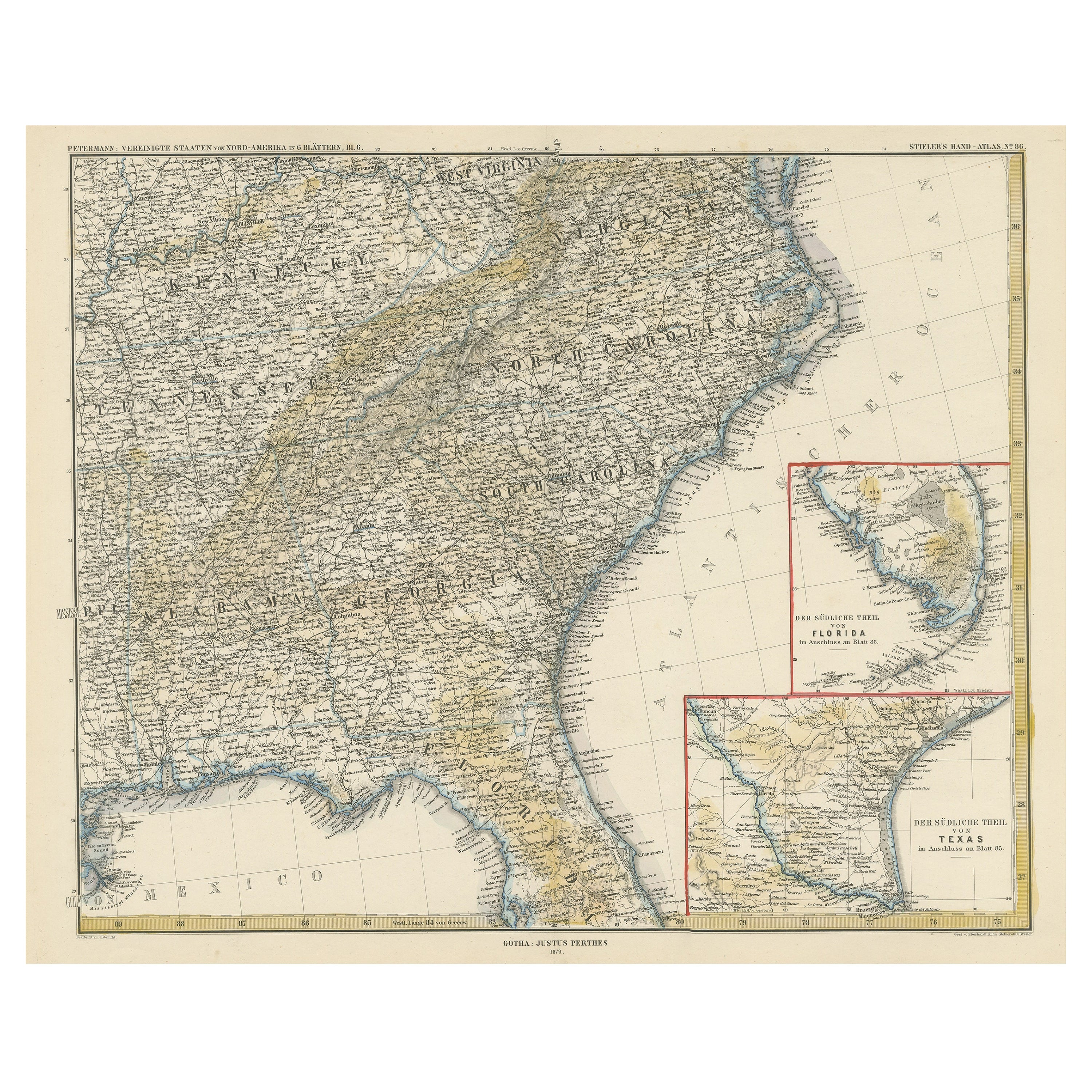
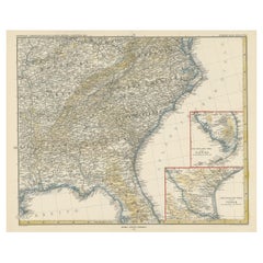
- Antique Map of the Region of Georgia with Inset Maps of Florida and TexasLocated in Langweer, NLAntique map of part of the United States showing Alabama, Georgia, North Carolina, South Carolina, Tennessee, Kentucky, Virginia and part of Florida. With inset maps of the southern ...Category
Antique Late 19th Century Maps
MaterialsPaper
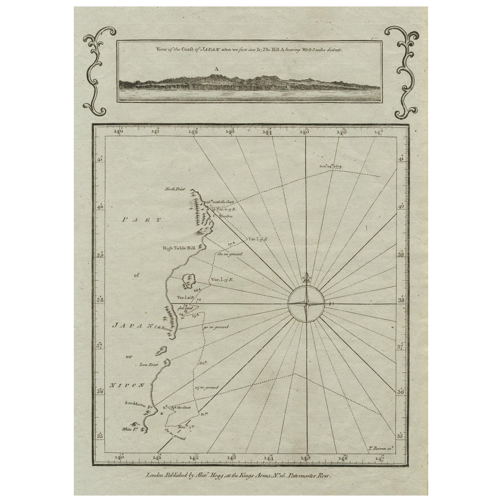
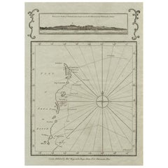
- Old Map of the East Coast of Honshu with an Inset, Japan, c.1785Located in Langweer, NLAntique map titled ‘Part of Japan or Nippon'. View of the Coast of Japan when we first saw it: The Hill a bearing West 3 miles distant. London Published by Allexer Hogg at the Kings Arms...Category
Antique 1780s Maps
MaterialsPaper
- Antique Map of the United States with inset map of the region of Mexico CityLocated in Langweer, NLAntique map titled 'Verein-Staaten von Nord-America, Mexico, Yucatan u.a.'. Very detailed map of the United States of America showing the Caribbean. With an inset map of the surround...Category
Antique Mid-19th Century Maps
MaterialsPaper
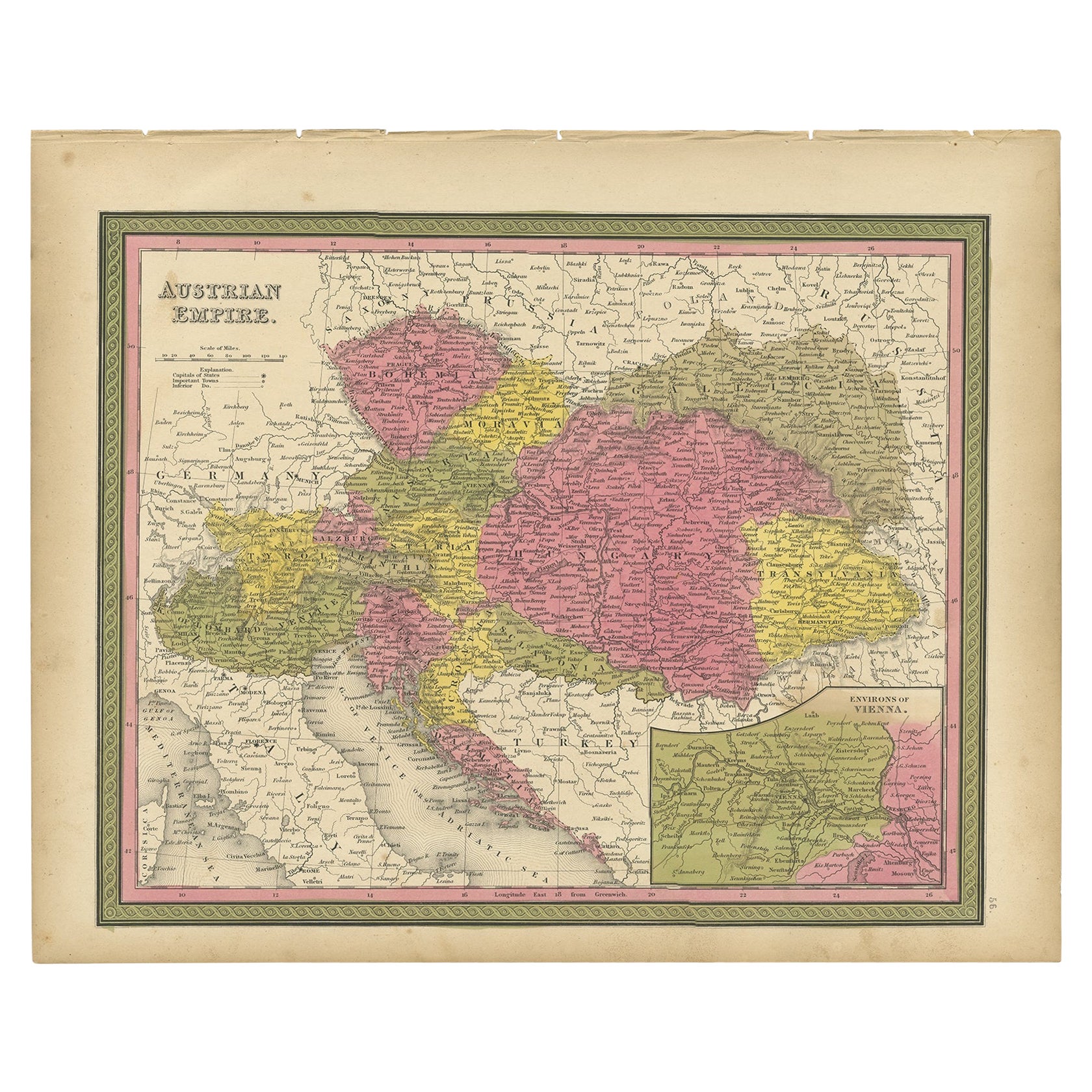
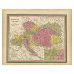
- Colourful Old Map of the Austrian Empire, with an Inset Map of Vienna, 1846Located in Langweer, NLAntique map titled 'Austrian Empire'. Old map of the Austrian Empire, with an inset map of Vienna. This map originates from 'A New Universal Atlas Co...Category
Antique 1840s Maps
MaterialsPaper
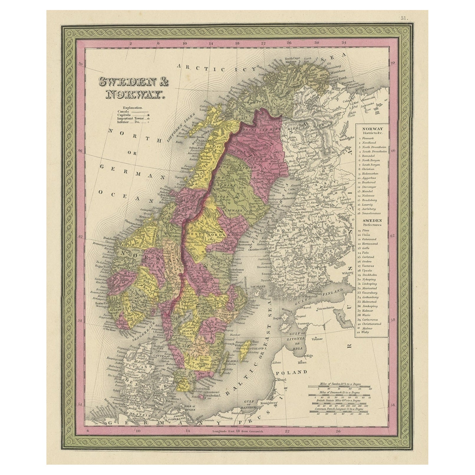
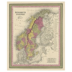
- Old Colourful Map of Sweden and Norway, 1846Located in Langweer, NLAntique map titled 'Sweden & Norway'. Old map of Sweden and Norway. This map originates from 'A New Universal Atlas Containing Maps of the various Em...Category
Antique 1840s Maps
MaterialsPaper


You May Also Like
- Original Antique Map of Spain and Portugal, circa 1790Located in St Annes, LancashireSuper map of Spain and Portugal Copper plate engraving by A. Bell Published, circa 1790. Unframed.Category
Antique 1790s English Other Maps
MaterialsPaper
- Original Antique Map of Spain and Portugal by Thomas Clerk, 1817Located in St Annes, LancashireGreat map of Spain and Portugal Copper-plate engraving Drawn and engraved by Thomas Clerk, Edinburgh. Published by Mackenzie And Dent, 1817 Unframed.Category
Antique 1810s English Maps
MaterialsPaper
- Original Antique Map of Spain and Portugal, Engraved By Barlow, 1806Located in St Annes, LancashireGreat map of Spain And Portugal Copper-plate engraving by Barlow Published by Brightly & Kinnersly, Bungay, Suffolk. 1806 Unframed.Category
Antique Early 1800s English Maps
MaterialsPaper
- 18th Century Hand Colored Map of Spain and Portugal by VisscherBy Nicolaes Visscher IILocated in Alamo, CAThis is an early 18th century map of Spain and Portugal, with attractive original hand-coloring, entitled "Hispaniae et Portugalliae Regna per Nicolaum Visscher cum Privilegio Ordinu...Category
Antique Early 18th Century Dutch Maps
MaterialsPaper
- The Normandy Region of France: A 17th C. Hand-colored Map by Sanson and JaillotBy Nicolas SansonLocated in Alamo, CAThis large hand-colored map entitled "Le Duché et Gouvernement de Normandie divisée en Haute et Basse Normandie en divers Pays; et par evêchez, avec le Gouvernement General du Havre ...Category
Antique 1690s French Maps
MaterialsPaper
- Old Nautical Map of CorsicaLocated in Alessandria, PiemonteST/556/1 - Old map of Corsica isle, surveyed by Captain Hell, of the French Royal Navy in 1824, engraved and published on 1874, with additions and corre...Category
Antique Early 19th Century English Other Prints
MaterialsPaper


Recently Viewed
View AllMore Ways To Browse
Madrid Furniture
Furniture In Madrid
Antiques From Spain
Old American Maps
Philadelphia Empire
American Empire Antiques
Antique Maps Of Philadelphia
Mitchell Antique Maps
Map Of Madrid
Island Colonial
Antique English County Maps
Portuguese 16th
Large Map Of The Netherlands
Antique Map Of The South Of France
Antique World Globe Map
Antique Hemisphere Maps
Antique Sea Chart
Bonne Map