Items Similar to Antique Map of Vlaams-Brabant by Homann Heirs, c.1720

Want more images or videos?
Request additional images or videos from the seller
1 of 7
Antique Map of Vlaams-Brabant by Homann Heirs, c.1720
About the Item
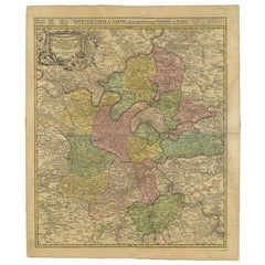
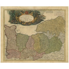
Antique map titled 'Ducatus Brabantiae Nova Tabula in qua (..).' Fully engraved copper plate map filled with details. Covers Flanders centered roughly on Ascot and delineating the walled and fortified cities of Brussels, Niville, Mechelen, Sandvliet, Breda, Megen, Eyndhoven, Tilmont and more. Very decorative figurative title cartouche with coat of arms, soldiers and putti. Source unknown, to be determined.
Artists and Engravers: Following the long period of Dutch domination, the Homann family became the most important map publishers in Germany in the eighteenth century, the business being founded by J.B. Homann in Nuremberg about the year 1702. Soon after publishing his first atlas in 1707 he became a member of the Berlin academy of Sciences and in 1715 he was appointed Geographer to the Emperor. After the founder's death in 1724, the firm was continued under the direction of his son until 1730 and was then bequeathed to his heirs on the condition that it trades under the name of Homann Heirs. The firm remained in being until the next century and had a wide influence on map publishing in Germany. Apart from the atlases the firm published a very large number of individual maps. The Homanns produced a Neuer Atlas in 1714, a Grosser Atlas in 1737, and an Atlas Maior with about 300 maps in 1780. They also issued a special Atlas of Germany with full sized plans of principal cities, school atlases and an Atlas of Silesia in 1750 with 20 maps.
Condition: Good, given age. Light staining and soiling in the margins. A few small spots. Original middle fold as issued. General age-related toning and/or occasional minor defects from handling. Please study image carefully.
Date: c.1720
Overall size: 53.5 x 64 cm.
Image size: 48.5 x 57.7 cm.
We sell original antique maps to collectors, historians, educators and interior decorators all over the world. Our collection includes a wide range of authentic antique maps from the 16th to the 20th centuries. Buying and collecting antique maps is a tradition that goes back hundreds of years. Antique maps have proved a richly rewarding investment over the past decade, thanks to a growing appreciation of their unique historical appeal. Today the decorative qualities of antique maps are widely recognized by interior designers who appreciate their beauty and design flexibility. Depending on the individual map, presentation, and context, a rare or antique map can be modern, traditional, abstract, figurative, serious or whimsical.
- Creator:Homann Heirs (Artist)
- Dimensions:Height: 25.2 in (64 cm)Width: 21.07 in (53.5 cm)Depth: 0 in (0.01 mm)
- Materials and Techniques:
- Period:
- Date of Manufacture:circa 1720
- Condition:Condition: Good, given age. Light staining and soiling in the margins. A few small spots. Original middle fold as issued. General age-related toning and/or occasional minor defects from handling. Please study image carefully.
- Seller Location:Langweer, NL
- Reference Number:
About the Seller
5.0
Platinum Seller
These expertly vetted sellers are 1stDibs' most experienced sellers and are rated highest by our customers.
Established in 2009
1stDibs seller since 2017
1,969 sales on 1stDibs
Typical response time: <1 hour
- ShippingRetrieving quote...Ships From: Langweer, Netherlands
- Return PolicyA return for this item may be initiated within 14 days of delivery.
More From This SellerView All
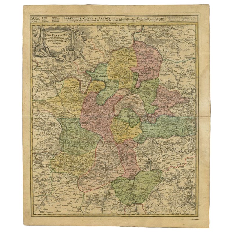
- Antique Map of the Region of Paris by Homann Heirs, c.1720By Homann HeirsLocated in Langweer, NLAntique map titled 'Agri Parisiensis Tabula particularis, qua maxima Pars Insulae Franciae (..).' Incredibly detailed map showing everything from tiny villages to forests, farmland, ...Category
Antique 18th Century Maps
MaterialsPaper
- Antique Map of the Seventeen Provinces by Homann Heirs, 1748By Homann HeirsLocated in Langweer, NLAntique map titled 'Belgii Universi seu Inferioris Germaniae quam XVII Provinciae (..)'. Map of the Seventeen Provinces after Tobias Meier, published by Homann's Heirs in 1748. The S...Category
Antique 18th Century Maps
MaterialsPaper
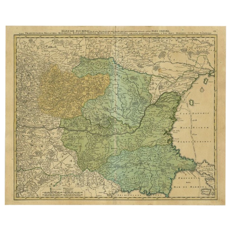
- Antique Map of the Danube River by Homann, c.1720By Homann HeirsLocated in Langweer, NLAntique map titled 'Danubii Fluminis (..)'. Regional map of the Donau river, Shows the Danube river from Belgrade in Serbia, along the border between Roma...Category
Antique 18th Century Maps
MaterialsPaper
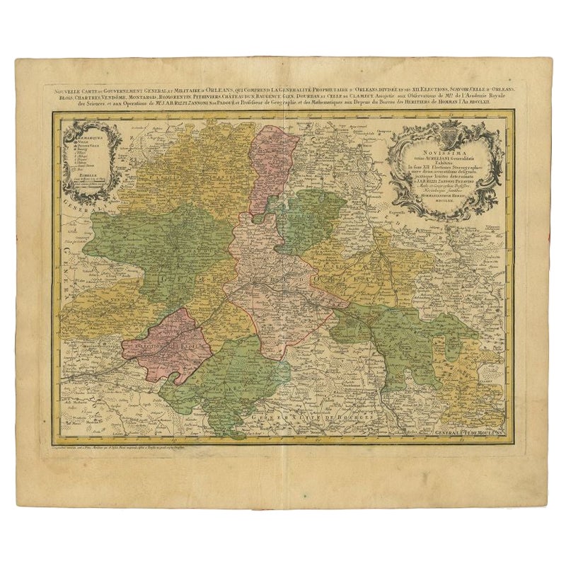
- Antique Map of the Region of Orleans by Homann Heirs, c.1760By Homann HeirsLocated in Langweer, NLAntique map titled 'Novissima Totius Aureliani Generalitatis (..) - Nouvelle Carte du Gouvernement General et Militaire d'Orleans (..).' Detailed map by Rizzi Zononi covering the vic...Category
Antique 18th Century Maps
MaterialsPaper
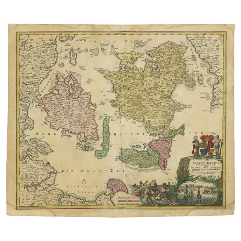
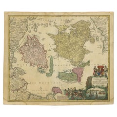
- Antique Map of the Islands of Denmark by Homann Heirs, 1720Located in Langweer, NLAntique map titled 'Insula Danicae in Mari Balthico sitae (..).' - Map of the Danish islands situated in the Baltic Sea by J. B. Homann, (after J. Hübner's map of the region ) with g...Category
Antique 18th Century Maps
MaterialsPaper
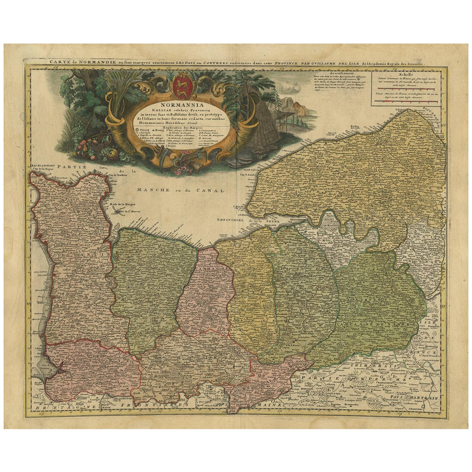
- Antique Map Normandy 'France' by Homann Heirs, Published in c.1740By Homann HeirsLocated in Langweer, NLAntique map France titled 'Normannia Galliae celebris Provincia in terras suas Ballisiatus (..)'. Decorative regional map of Normandy, France, circa ...Category
Antique Mid-18th Century German Maps
MaterialsPaper

You May Also Like
- Sweden & Adjacent Portions of Scandinavia: A Hand-Colored 18th C. Map by HomannBy Johann Baptist HomannLocated in Alamo, CAThis hand-colored map of Sweden and adjacent portions of Scandinavia entitled "Regni Sueciae in Omnes suas Subjacentes Provincias accurate divisi Tabula Generalis" was created by Joh...Category
Antique 1720s German Maps
MaterialsPaper
- Antique Coaching Road Map, Devon, English, Regional Cartography, Georgian, 1720Located in Hele, Devon, GBThis is an antique coaching road map of Devon. An English, framed lithograph engraving of regional interest, dating to the early 18th century and later. Fascinating 18th century hig...Category
Antique Early 18th Century British Georgian Maps
MaterialsWood
- Antique Coach Road Map, East Devon, English, Framed, Cartography, Georgian, 1720Located in Hele, Devon, GBThis is an antique coach road map of East Devon. An English, framed lithograph engraving of regional interest, dating to the early 18th century and later. Fascinating 18th century h...Category
Antique Early 18th Century British Georgian Maps
MaterialsWood
- Scandinavia & Portions of Eastern Europe: 18th Century Hand-Colored Homann MapBy Johann Baptist HomannLocated in Alamo, CAAn early 18th century hand-colored copper-plate map entitled "Regni Sueciae in omnes suas Subjacentes Provincias accurate divisi Tabula Generalis" by Johann Baptist Homann (1663-1724...Category
Antique Early 18th Century German Maps
MaterialsPaper
- Hand-Colored 18th Century Homann Map of the Danube, Italy, Greece, CroatiaBy Johann Baptist HomannLocated in Alamo, CA"Fluviorum in Europa principis Danubii" is a hand colored map of the region about the Danube river created by Johann Baptist Homann (1663-1724) in his 'Atlas Novus Terrarum', publish...Category
Antique Early 18th Century German Maps
MaterialsPaper
- 18th Century Hand-Colored Homann Map of Germany, Including Frankfurt and BerlinBy Johann Baptist HomannLocated in Alamo, CAAn 18th century hand-colored map entitled "Tabula Marchionatus Brandenburgici et Ducatus Pomeraniae quae sunt Pars Septentrionalis Circuli Saxoniae Superioris" by Johann Baptist Homa...Category
Antique Early 18th Century German Maps
MaterialsPaper


Recently Viewed
View AllMore Ways To Browse
Antique Wall Maps
World Map Wall
Wall Map Of The World
Antique Wall Maps Of The World
Large Wall Map
Collectable Wall Plates
Large Wall Maps
Coat Of Arms German
German Putti
Large Antique Copper Plate
Large Antique Wall Map
Wall Decorator Plates
Nova Light
Flanders 18th
16th Century Putti
Silesia Plate
Nova Copper
Antique Caribbean Maps