Items Similar to Framed 1838 North America & Recent Discoveries Map

Want more images or videos?
Request additional images or videos from the seller
1 of 10
Framed 1838 North America & Recent Discoveries Map
About the Item
1838 map of North America & recent discoveries. Engraved color map by J. Wyld, London, England. This map shows Texas as a Republic without its panhandle.
Framed in brown carved wood frame.
- Dimensions:Height: 24 in (60.96 cm)Width: 20 in (50.8 cm)Depth: 1.25 in (3.18 cm)
- Style:American Classical (In the Style Of)
- Materials and Techniques:
- Place of Origin:
- Period:
- Date of Manufacture:1838
- Condition:Additions or alterations made to the original: Reframed. Wear consistent with age and use.
- Seller Location:Stamford, CT
- Reference Number:1stDibs: LU1860320213442
About the Seller
5.0
Platinum Seller
These expertly vetted sellers are 1stDibs' most experienced sellers and are rated highest by our customers.
Established in 2010
1stDibs seller since 2016
397 sales on 1stDibs
Typical response time: 1 hour
- ShippingRetrieving quote...Ships From: Stamford, CT
- Return PolicyA return for this item may be initiated within 2 days of delivery.
More From This SellerView All
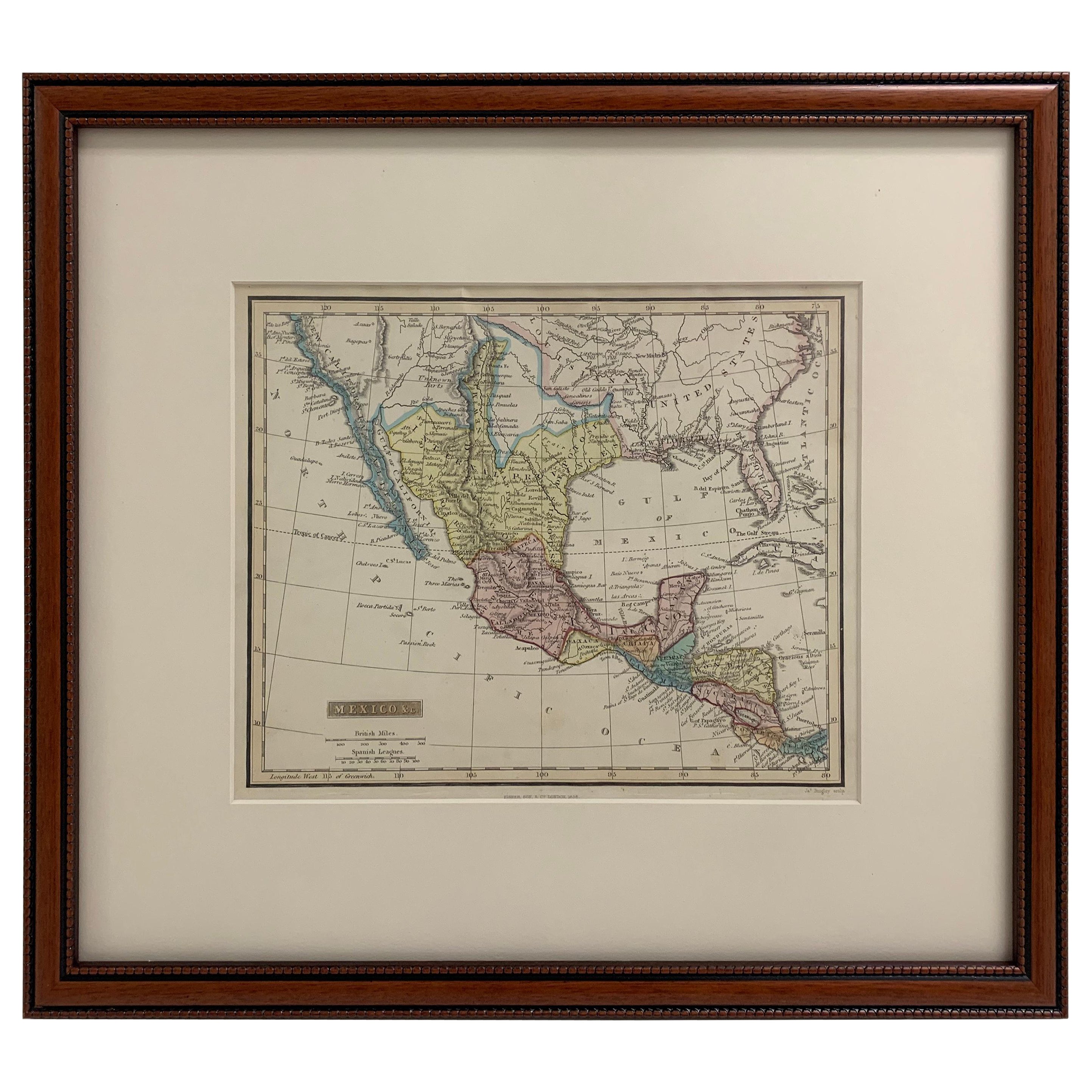
- Framed 1838 Mexico & Gulf of Mexico MapLocated in Stamford, CTFramed 1838 Mexico & Gulf of Mexico map. Printed by Fisher, Son & Co. of London in 1838. As found framed condition. Map has not been examined outside of th...Category
Antique 1830s English American Classical Maps
MaterialsGlass, Wood, Paper
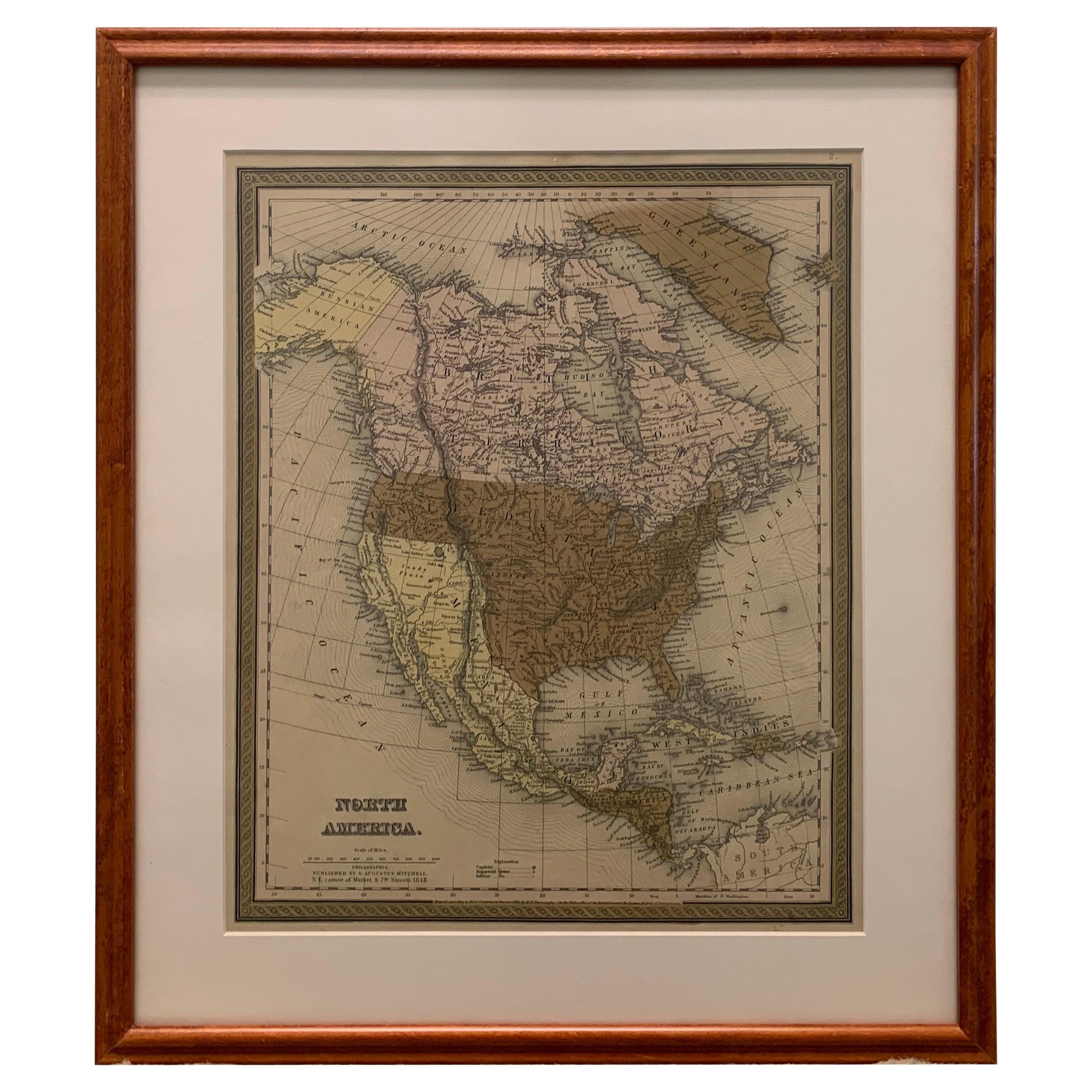
- Large 1848 North America & Territories MapLocated in Stamford, CTFramed 1848 S. Augustus and Mitchell, Philadelphia , PA North America and territories map. Featuring the United States, Canada (British Territory) and Mexican Territories. As found...Category
Antique 1840s American American Classical Maps
MaterialsGlass, Wood, Paper
- 1830 Mexico and United States Framed MapLocated in Stamford, CTMap of North America published circa 1830. Map shows United States into Canada. Mexico extending into the upper California territory. Texas appears in name but prior to the period of...Category
Antique 1830s American American Classical Maps
MaterialsGlass, Wood, Paper
- 1834 Mexico & Guatemala Framed Map by H.S. TannerLocated in Stamford, CT1834 Mexico & Guatemala map of published by H.S. Tanner, Philadelphia, Pennsylvania. Engraved by J. Knight. As found high end custom framing with carved wood frame, custom matting a...Category
Antique 1830s American American Classical Maps
MaterialsGlass, Wood, Paper
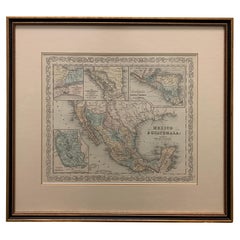
- Large 1856 Mexico & Guatemala Framed Map by Charles DesilverLocated in Stamford, CTLarge 1856 Mexico & Guatemala Framed map. Published by Charles Desilver, Philadelphia, Pennsylvania. As found high end custom framing with black giltwood frame, custom matting and UV...Category
Antique 1850s American American Classical Maps
MaterialsGlass, Wood, Paper
- Framed 1839 Hand Colored Map of the United StatesLocated in Stamford, CTFramed hand colored map of the United States of America from 1839. Newly framed in a giltwood frame.Category
Antique 1830s American American Classical Maps
MaterialsGiltwood, Paper, Glass


You May Also Like
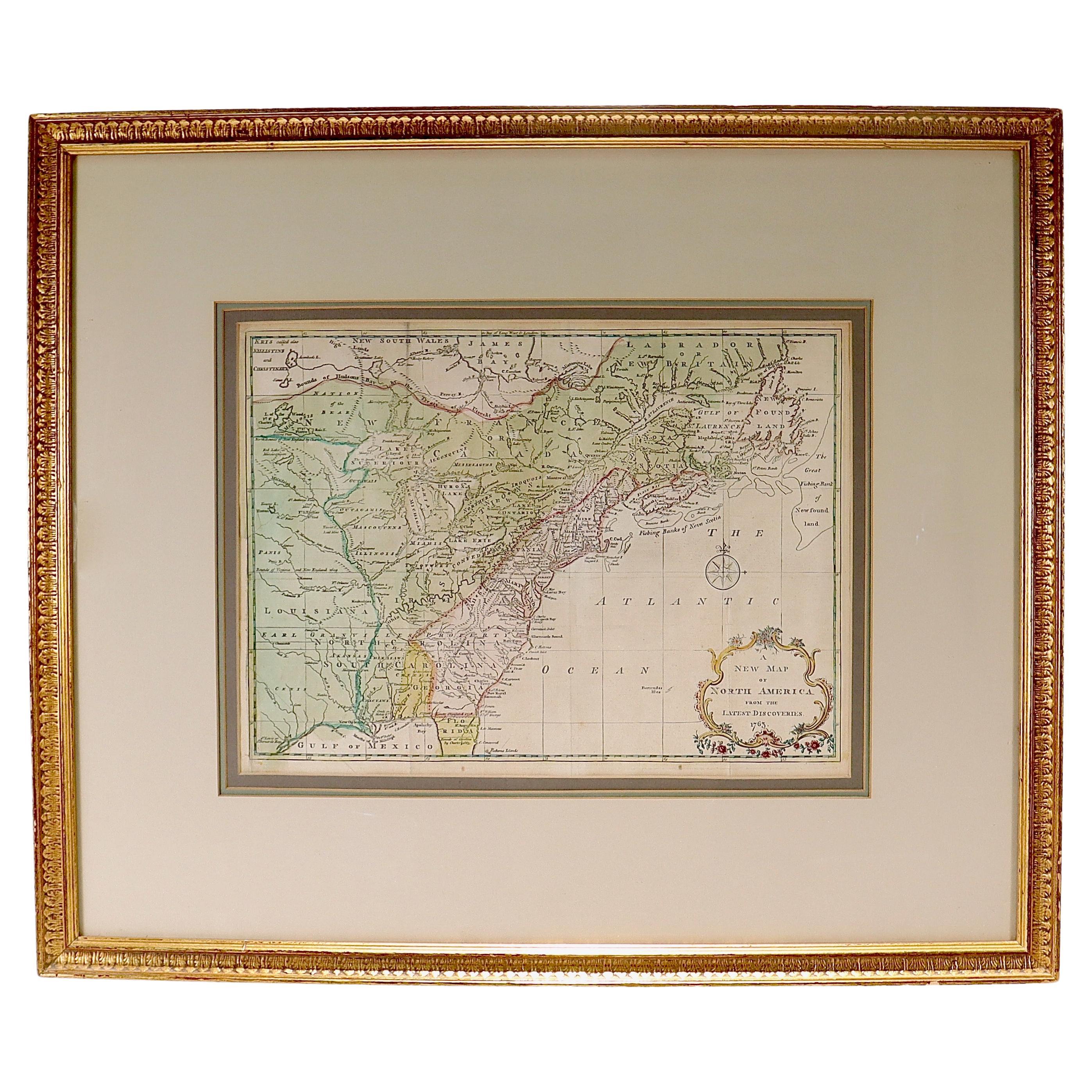
- New Map of North America from the Latest Discoveries, 1763Located in Philadelphia, PAA fine antique 18th century map of the North American seaboard. Entitled "A New Map of North America from the Latest Discoveries 1763". By the Cartographer/Engraver - John Spil...Category
Antique Mid-18th Century English Georgian Maps
MaterialsPaper
- Antique Map of North America, 1821Located in Langweer, NLAntique map of America titled 'Carte de l'Amerique septentrionale'. Scarce map of North America, shortly after the Louisiana Purchase and the first ...Category
Antique 19th Century Maps
MaterialsPaper
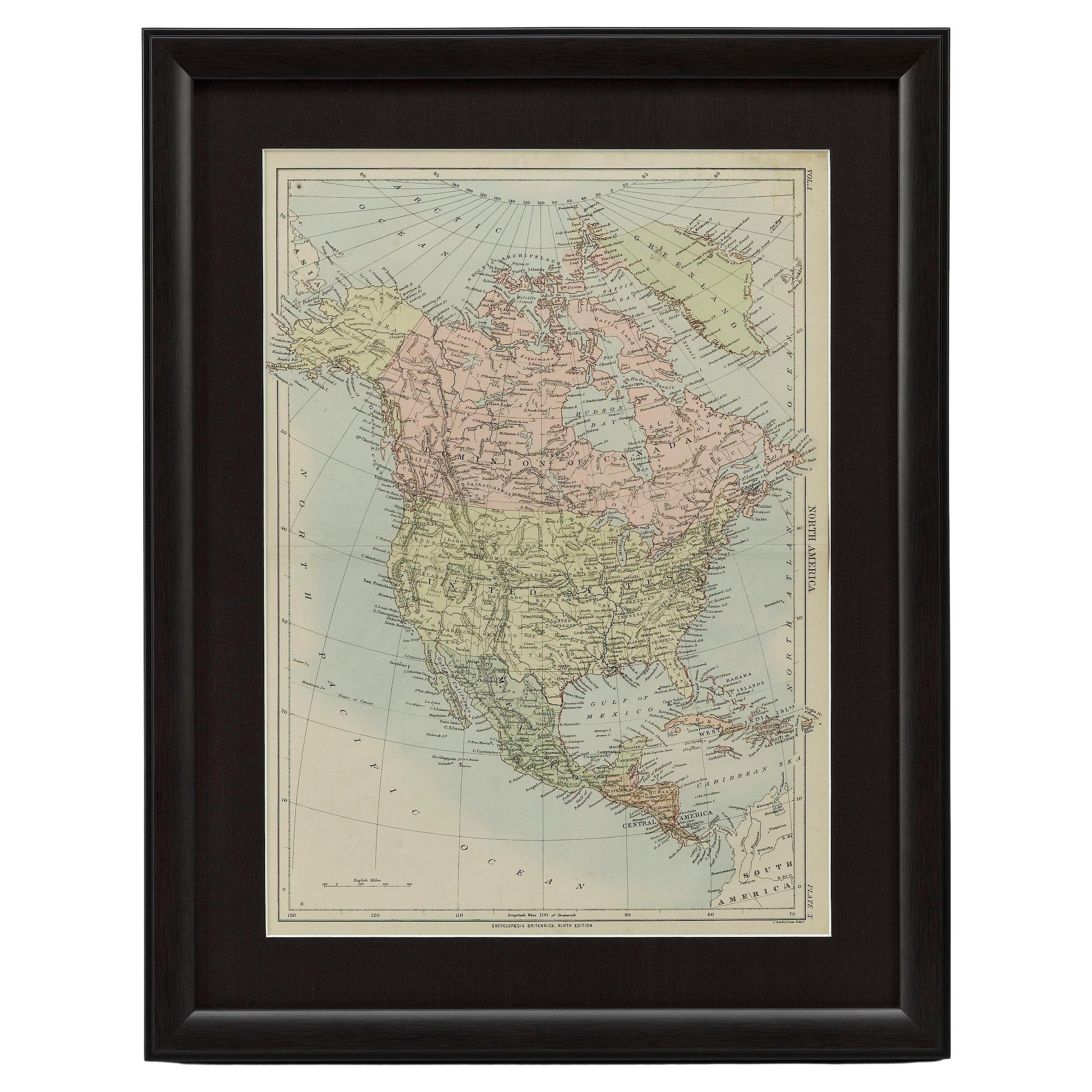
- 1875 "North America" Map by J. BartholomewLocated in Colorado Springs, COPresented is an original 1875 map of “North America.” The map was issued in Volume 1 of the Ninth Edition of the Encyclopædia Britannica, published in Edinburgh. The map was drawn by famous Scottish mapmaker John Bartholomew. The map depicts North America, to include Greenland, the Dominion of Canada, the United States, Mexico, the countries of Central America, and the islands of the West Indies. Prominent rivers, mountain ranges, and cities are labeled on the map, and country borders are emphasized in red. The Encyclopædia Britannica has been published continuously since 1768, appearing in fifteen official editions. The landmark ninth edition of the Encyclopædia Britannica, often called "the Scholar's Edition," was published from January 1875 to 1889 in 25 volumes. The editor and author of the “Foreword” was Thomas Spencer Baynes, the first English-born editor after a series of Scots. After 1880, Baynes was assisted by William Robertson Smith. The 9th edition is often lauded as a high point among early editions for scholarship. The 9th edition was far more luxurious than any previously printed Encyclopædia Britannicas, with thick boards and quality leather bindings, premier paper, and a production which took full advantage of the technological advances of printing in the years between the 1850s and 1870s. The publishers took advantage of the new ability to print large graphic illustrations on the same pages as the text, as opposed to limiting illustrations to separate copper plate engravings. Although this technology had first been used in a primitive fashion the 7th edition, and to a much lesser extent in the 8th, in the 9th edition there were thousands of quality illustrations and maps set...Category
Antique 1870s Scottish Maps
MaterialsPaper
- University Chart “Black Map of North AmericaLocated in Chillerton, Isle of WightUniversity Chart “Black Map of North America W&A K Johnston’s Charts of Physical Maps By G W Bacon, This is a Black Physical map of North A...Category
Early 20th Century Industrial Maps
MaterialsLinen
- Large Antique 1859 Map of North AmericaLocated in Sag Harbor, NYThis Map was made by Augustus Mitchell in 1859 It is in amazing condition for being 163 years old. This price is for the rolled up easy to ship version of this piece. I will be Frami...Category
Antique Mid-19th Century American Maps
MaterialsCanvas, Paper

- Antique Map of North America by Lapie '1842'Located in Langweer, NLAntique map titled 'Carte de l'Amérique septentrionale'. Map of North America, with an inset map of the Aleutian Islands. This map originates from 'Atlas universel de géographie anci...Category
Antique Mid-19th Century Maps
MaterialsPaper


Recently Viewed
View AllMore Ways To Browse
London England
United States Map
Antique Maps London
London Antique Maps
Antique American Maps
Antique Map Of America
Framed Map
1830 America
Antique Map Framing
Antique Maps Framed
Framing Antique Maps
Antique Map United States
Antique United States Maps
Framed Map United States
Antique Maps North America
Antique Maps Of North America
Texas Maps
Map Of Texas