Items Similar to England Map of the County of Southampton from an Actual Survey


Want more images or videos?
Request additional images or videos from the seller
1 of 5
Christopher & John GreenwoodEngland Map of the County of Southampton from an Actual Survey1817-1832
1817-1832
About the Item
Cartographers Christopher (1786-1855) and John (1791-1867) Greenwood were surveyors from Yorkshire, who undertook an ambitious project to produce a series of large-scale maps of the counties of England, Wales and Scotland.The maps represent a remarkable and impressive surveying achievement forming an important record of the counties depicted.
In the years 1817-1832 the Greenwood brothers published the Atlas of The Counties of England from an Actual Survey. This Atlas was finely drafted and engraved and decorated with large vignettes of prominent buildings of the county. This map of Southampton County is beautifully hand colored and is in very good condition. There is a vignette of Winchester Cathedral in the lower right corner.
- Creator:Christopher & John Greenwood (1786 - 1867)
- Creation Year:1817-1832
- Dimensions:Height: 25.25 in (64.14 cm)Width: 31 in (78.74 cm)
- Medium:
- Period:
- Condition:
- Gallery Location:Paonia, CO
- Reference Number:1stDibs: LU78033567581
About the Seller
4.9
Vetted Seller
These experienced sellers undergo a comprehensive evaluation by our team of in-house experts.
Established in 1978
1stDibs seller since 2017
105 sales on 1stDibs
Typical response time: 12 hours
- ShippingRetrieving quote...Ships From: Paonia, CO
- Return PolicyA return for this item may be initiated within 7 days of delivery.
More From This SellerView All
- Persiae, Armeniae, Natoliae et Arabiae Descriptio per Frederick deWit 1666 mapLocated in Paonia, COMap of Persiae, Armeniae, Natoliae et Arabiae Descriptio per F de Wit 1688 engraving from: Atlas Contractus Orbis Terrarum Praecipuas ac Novissimas Complectens Tabulas. Amsterdam, N. Visscher, 1656-77. (Koeman III, Vis5-8) This highly decorative map of the Middle East is by the Dutch engraver, publisher, and map seller...Category
1660s Realist Landscape Prints
MaterialsEngraving
- A View at Bolcheretzko (Russia) 1784 Captains Cook Final Voyage by John WebberBy John WebberLocated in Paonia, COA View at Bolcheretzko (Russia) is from the 1784 First Edition Atlas Accompanying Capt. James Cook and King; Third and Final Voyage of Captain James Cook.John Webber (1752-1793) was ...Category
1780s Realist Landscape Prints
MaterialsEngraving
- Three Varieties of Leucoium , Hortus Eystettensis, ( after ) BeslerBy (After) Basilius BeslerLocated in Paonia, COThree Varieties of Leucoium (I. Leucoium purpureum variegatum flore pleno. II Leucoium pleno flor album purpureis maculis signatum. III. Leucoium pleno flor album sanguine maculis signatum), from B. Besler, Hortus Eystettensis possibly (after) Basil Besler...Category
Early 17th Century Landscape Prints
MaterialsEngraving
- Map of the County of Buckingham From an Actual SurveyLocated in Paonia, COCartographers Christopher (1786-1855) and John (1791-1867) Greenwood were surveyors from Yorkshire, who undertook an ambitious project to produce a series of large-scale maps of the counties of England, Wales and Scotland.The maps represent a remarkable and impressive surveying achievement forming an important record of the counties depicted. In the years 1817-1832 the Greenwood brothers published the Atlas of The Counties of England from an Actual Survey. This Atlas was finely drafted and engraved and decorated with large vignettes of prominent buildings of the county. This map of Buckingham County is beautifully hand colored and is in very good condition. There is a vignette of Stowe House...Category
19th Century Other Art Style More Prints
MaterialsEngraving
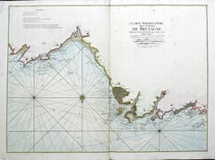
- Carte Particular Des Costes De Bretagne Depuis le Cap de Frehel, Jusques a PerrosBy Pierre MortierLocated in Paonia, COCarte Particulaire Des Costes De Bretagne Depuis Le Cap de Frehel, Jusques a Perros, & L’Isle Tome. This large sea scale chart shows part of the northwestern co...Category
1690s Landscape Prints
MaterialsEngraving
- Carte Particuliere Des Coste De Bretagne qui Comprend MorlaixBy Pierre MortierLocated in Paonia, COCarte Particuliere Des Costes De Bretagne qui Comprend Morlaix, Saint Paul de Leon, les Sept Isles, et L’Isle. Faite par ordre Exprez Du Roy de France is from the collection of ch...Category
1690s Landscape Prints
MaterialsEngraving


You May Also Like
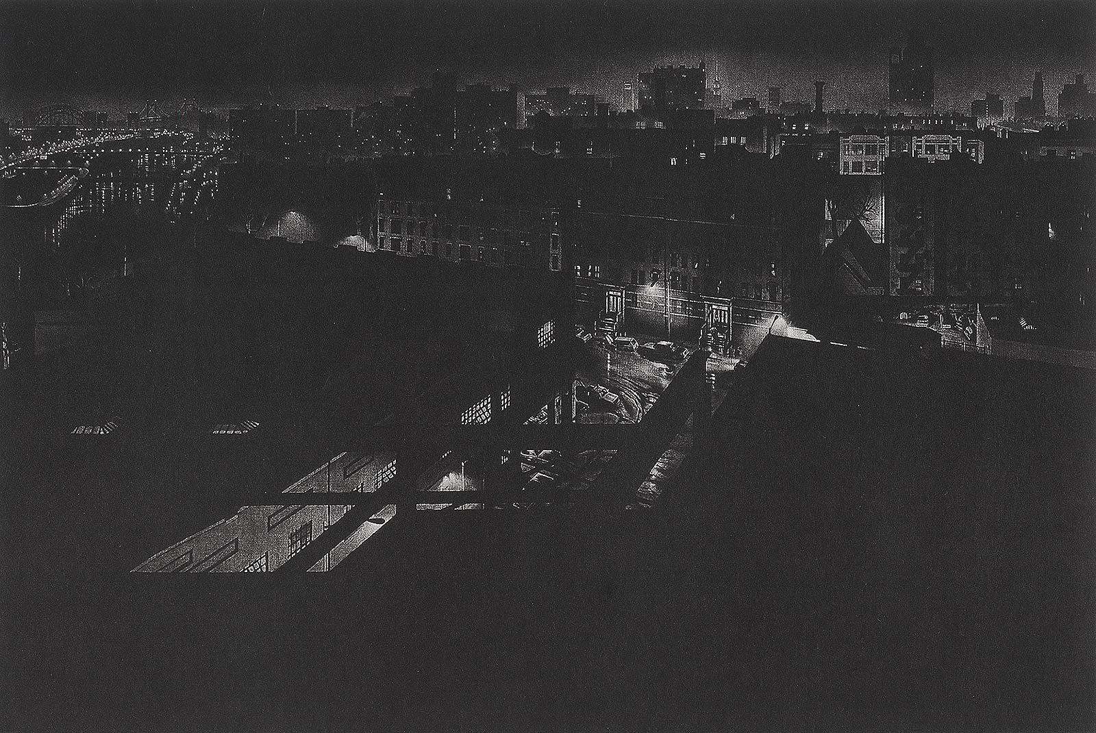
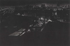
- Girders (rainy night view of artist's former studio in Washington HeightsBy Craig McPhersonLocated in New Orleans, LA"Griders" is Craig McPherson's rainy night scene showing the view from his former studio in Washington Heights in NYC. The image is the companion pi...Category
1980s Contemporary Landscape Prints
MaterialsMezzotint
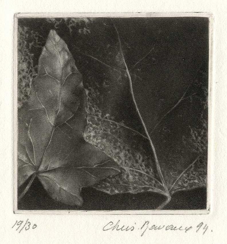
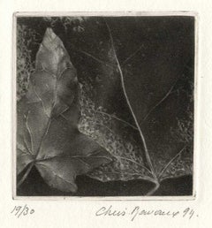
- LeavesBy Christine RavauxLocated in New Orleans, LAThis impression is #19 out of an edition 30 Born in 1961 in Charleroi, Belgium, Ravaux is an artist who mirrors her surroundings in the mezzotints she creates. She has portrayed see...Category
1990s American Modern Landscape Prints
MaterialsMezzotint
- L'Isle de France: A Hand-colored 17th Century Map by De WitBy Frederick de WitLocated in Alamo, CAThis colorful and detailed 17th century hand-colored copperplate map by Frederick De Wit was published in Amsterdam between 1666 and 1760. The map depicts the Île-de-France, which is one of the ancient provinces of France. Paris is located in the center of the map, with Versailles to the southwest The map extends from Rouen in the west to Reims in the east. The area around Paris, the Véxin Français, was the original domain of the king of France. Other areas were ruled by French feudal lords. For example, the Véxin Normand area was the domain of the Duke of Normandy...Category
Early 18th Century Old Masters More Prints
MaterialsEngraving
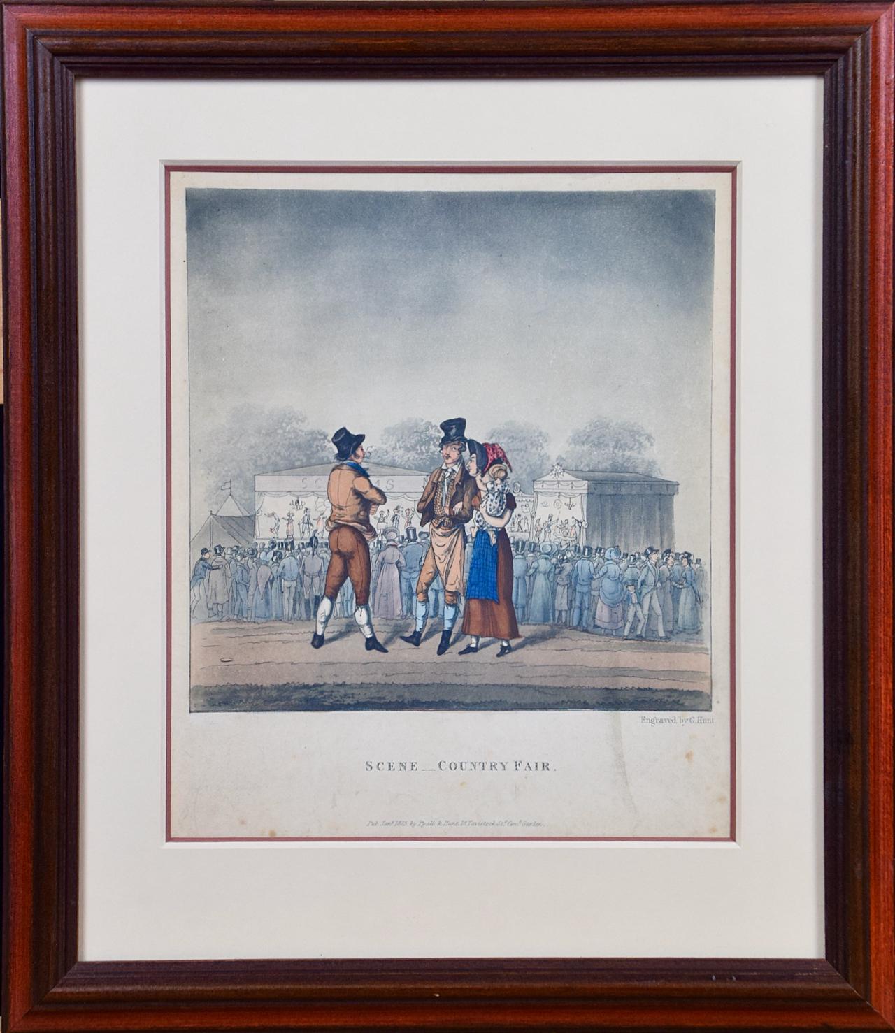
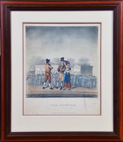
- "Scene _ Country Fair": A Framed Early 19th Century Engraving by George HuntBy George HuntLocated in Alamo, CAThis is a framed colored engraving entitled "Scene _ Country Fair" by George Hunt, published in London in 1825. It depicts a gathering of people at an early 19th century county fair, presumably in England. A majority of the crowd are turned away, watching a performance on a stage in the background. In the foreground a man is in conversation with a couple. The man wears a top hat and the woman is holding a baby. They are dressed in the typical attire of the middle class at that time. The engraving is presented in a brown wood frame and a double mat, with a cream-colored outer mat and a light cranberry...Category
Early 19th Century Landscape Prints
MaterialsEngraving
- View of Seravalle, Italy: A 16th Century Hand-colored Map by Braun & HogenbergBy Franz HogenbergLocated in Alamo, CAThis is an original 16th century copperplate originally hand-colored engraved map of View of Seravalle, Italy entitled "Seravallum Celeberrimum Marchiae Tarvisiniae in Agro Foro Juliensi Opp. - Seravalli, quam vides, Spectator, iconem, operi huic nostro suis sumptib. . . ." by Georg Braun & Franz Hogenberg, from their famous city atlas "Civitates Orbis Terrarum", published in Augsberg, Germany in 1575. The map depicts a view of Seravalle, now Vittorio Veneto, in San Marino, Italy, north of Venice, in a topographically accurate bird's-eye view from the south. A water-filled moat is seen to the south of the city walls and farmland to the east. Two men are depicted standing on a hill in the lower right in conversation next to grain sacks and a grazing horse, while a younger man behind them to the right herds a mule carrying presumably pigs. A very colorful and ornate title cartouche is in the upper center and coat-of-arms are in the right and left upper corners. Serravalle lies in an idyllic setting in the foothills and surrounded by orchards. St Mary's Cathedral with its tall bell tower is prominent in the center of the town. The marketplace and town hall with a bell tower in the square are depicted. Houses and shops are around the main square. Serravalle's importance as an agricultural centre is emphasized by the figures in the foreground. In 1337 Serravalle was conquered by the Republic of Venice. In 1866 the town was united with neighbouring Ceneda to form the town of Vittorio Veneto. The following is an English translation of an excerpt from the French description of the city on the back of the map: "Serravalle, a market town renowned for cloth, wine and grain, is in such a beautiful situation that the number of its inhabitants, attracted by the loveliness of the place, has grown so much at times that the wall encircling it has had to be enlarged for the third time. The city with the surrounding town once belonged to the Church in Ceneda as an imperial fief. It subsequently became the seat of the Da Camino family (a princely house that at that time was one of the five most noble in all Italy). Now the city is under the sway of the Venetians but is prudently governed by them. For they send only one city councillor with instructions to ensure that justice prevails and to collect duties. In all else, power lies in the hands of the noble families." This is a translation of the Latin in the title cartouche on the front: "The picture of the town of Serravalle, which you see, viewer, has been contributed to our work entirely at his own expense by Minutius, son of Hieronymus Minutius, a noble gentleman and one renowned for the far-reaching competence of his jurisdiction. We saw him sojourning in Cologne, where he was on business for Gregory XIII; while our good wishes accompany him, we should also like to accompany him on his way with this remembrance, even though it might be against his will, so that even those who have not seen him may learn of his excellence. However, those who do not yet know him will also see his excellence if God the Almighthy does not summon erring souls too soon back to the eternal seat of the Blessed." References: Van der Krogt 4, 4728, State 1; Taschen, Braun and Hogenberg, p.331; Fauser, #14960 This striking hand-colored city view is printed on laid, chain-linked paper with wide margins. The sheet measures 16" high by 21" wide. There is a central vertical fold as issued and French text on the verso, with Latin on the front. There is some discoloration in the upper and right margins which may represent some watercolor paint from the time of the original hand-coloring of the map. There is a small hole to the right of the upper portion of the vertical fold, which is only visible when held up to light and an area of reinforcement on the verso of the lower vertical fold. The map is otherwise in very good to excellent condition. Braun and Hogenberg's 'The Civitates Orbis Terrarum' was the second atlas of maps ever published and the first atlas of cities and towns of the world. It is one of the most important books published in the 16th century. Most of the maps in the atlas were engraved by Franz Hogenberg and the text, with its descriptions of the history and additional factual information of the cities, was written by a team of writers and edited by Georg Braun. The work contained 546 bird-eye views and map views of cities and towns from all over the world. It gave graphic representation of the main features of the illustrated cities and towns, including the buildings and streets. Although the ordinary buildings are stylized, the principal buildings are reproduced from actual drawings created on location. The principal landmarks and streets can still be recognized today. In addition, the maps often include the heraldic arms of the city, the nature of the surrounding countryside, the important rivers, streams and harbors, even depicting stone bridges, wooden pontoons, flat-bottomed ferries, ships and working boats, wharves and jetties, as well as land-based activities, including horsemen, pedestrians, wagons, coaches, and palanquins. Small vignettes are often included which illustrate the trade, occupations and habits of the local inhabitants, such as agriculture, paper-making and textiles, as well as local forms of punishment, such as gibbets, wheels, floggings etc. Large figures dressed in their local costume are often presented out of proportion in the foreground. The aim of the authors was to give as much information as possible in a pleasing visual form. They succeeded in creating maps that were both informative and decorative works of art. The atlas is a wonderful glimpse of life in medieval Europe. Georg Braun (1541-1622) was German Catholic...Category
16th Century Old Masters Landscape Prints
MaterialsEngraving
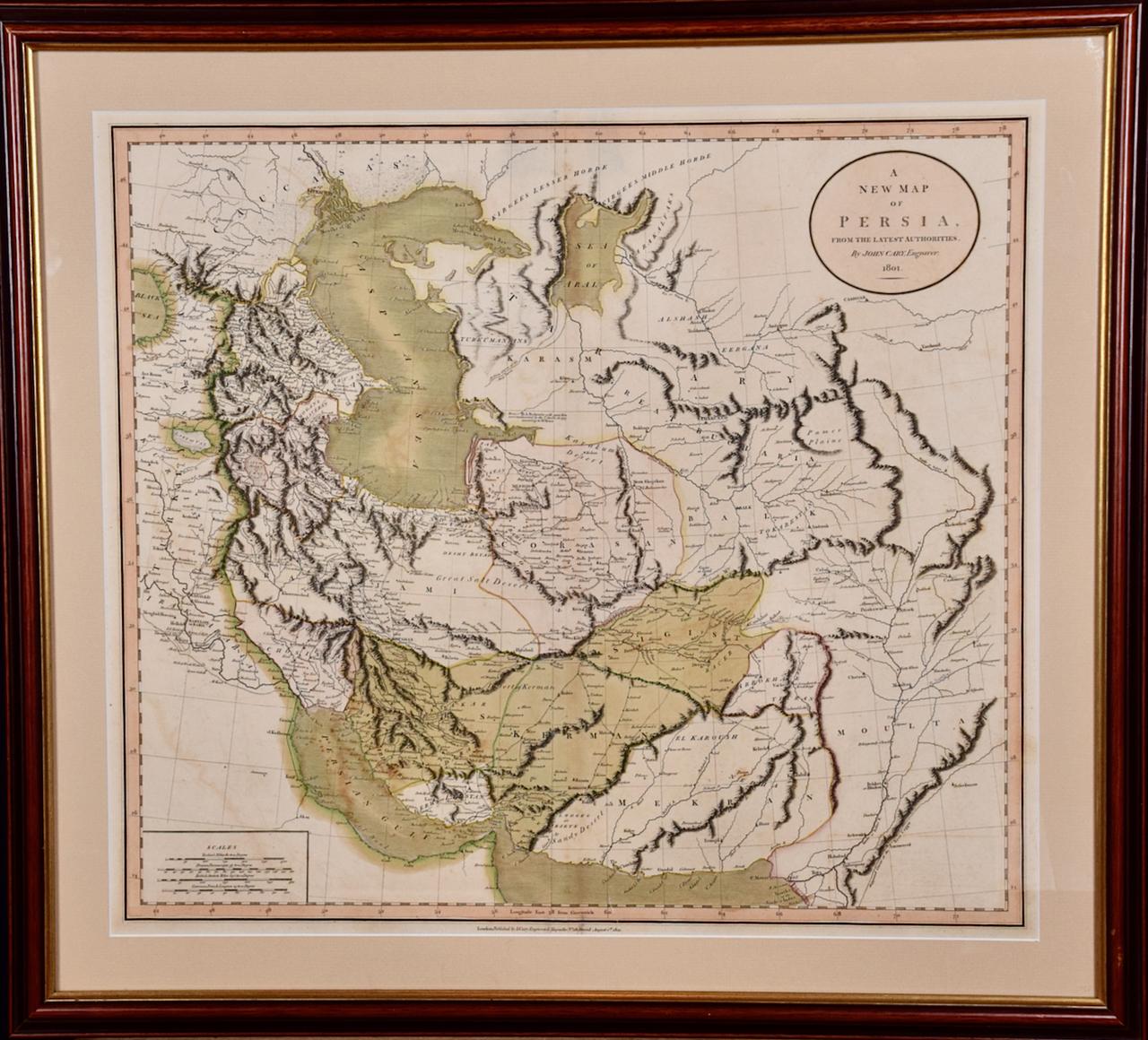
- Persia & Afghanistan: A Framed Hand-colored 17th Century Map by John CaryBy John CaryLocated in Alamo, CAThis colorful and detailed early 18th century copperplate map by John Cary entitled "A New Map of Persia from the Latest Authorities" was published in London in 1801. It depicts Persia, the region of modern day Afghanistan, the Caspian Sea, the Sea of Aral, the Persian Gulf...Category
Early 19th Century Old Masters More Prints
MaterialsEngraving


Recently Viewed
View AllMore Ways To Browse
Scotland And England
Antique Survey
Antique Surveying
Antique Maps Wales
Antique Maps Of Wales
Antique Surveyor
Antique Surveyors
Yorkshire Map
Antique Map Of Yorkshire
Antique Maps Yorkshire
Map Southampton
Tony Bennett Lithographs
Travel Poster Lourdes
1997 Andy Warhol Chanel Blue Lithograph
Adolphe Beaufrere
Allison Bianco
Ana Popescu
Bill Ogden