Items Similar to 18th C. Architectural Engraving from "Vitruvius Britannicus" by Colen Campbell
Want more images or videos?
Request additional images or videos from the seller
1 of 11
Colen Campbell18th C. Architectural Engraving from "Vitruvius Britannicus" by Colen Campbell 1715
1715
About the Item
"The Elevation of a New Design of my Own Invention in the Style of Inigo Jones, Is most humbly Inscribed to his Grace the Duke of Argyle & Knight of the most Noble Order of the Garter", plate 20 from Colen Campbell's first edition of "Vitruvius Britannicus; or The British Architect, Containing the Plans, Elevations, and Sections of the most Regular Buildings both Publick & Private in Great Britain, with a Variety of New Designs", published in London in 1715.
Campbell's description of his plans created for the home of the Duke of Argyle: "I Have inscrib’d this Design to this illustrious Name, whose great Actions have filled the World with Surprize and Admiration; Ramellies and Tanniers are immortal. And as it’s my greatest Honour to receive my Blood from his August House, I thought I could no where so properly consecrate the first Essay of my Invention, as an eternal Monument of the deepest Respect and Gratitude. I have given two Plates: In the first are two Plans in a Square of 112 Foot; the Apartments of State are below, raised from the Court by 6 Steps which leads into the great Hall, making a Cube of 50 Foot, and has a Poggio within dividing the two Stories; from the Hall you enter the Salon, attended with two noble Apartments of State fronting the Gardens; all the Rooms are either upon the Square, the Diagonal, or other Proportions universally received: In the second Story is a large Library, an Antichamber of each side, with double Apartments; over which are Mezonins, for accommodating the Family, illuminated by low Laterns from the Leads, whereby the Majesty of the Front is preserved from the ill Effect of crowded Apertures. The second is the Front, raised from the Plinth which supports the Rusticks, adorned with a Composite Order of ¼ Columns, with a regular Entablature and Ballustrade; the Windows are dress’d in the Palladian manner: And I have endeavoured to reconcile the Beauty of an Arcade in the ancient Buildings with the Conveniency of the Moderns, but must leave it to others to judge the Success. Anno 1714."
Colen Campbell (1676-1729) was a Scottish lawyer and architect. His landmark and richly illustrated "Vitruvius Britannicus" was the single most influential work of architecture published in the Georgian era. The title of the publication plays homage to the writings of the Roman architectural author, Vitruvius and illustrates his and other contemporary British architects interest in returning to classical designs rather than the recent excessive Baroque architecture with French influence. It illustrated the work of great British architects of his time, including Sir Christopher Wren and Campbell's own designs, which were inspired by earlier classical architects, including the 17th century British architect Inigo Jones and the sixteenth-century Italian architect, Andrea Palladio.
The print is presented in a gold frame, beige colored silk mat and embellished with a gold fillet. The print is in very good condition other then some linear marks in the lower margin, which most likely occurred at the time of printing in 1715.
- Creator:Colen Campbell (1676 - 1729, British)
- Creation Year:1715
- Dimensions:Height: 17.25 in (43.82 cm)Width: 22.25 in (56.52 cm)Depth: 0.75 in (1.91 cm)
- Medium:
- Period:1710-1719
- Condition:
- Gallery Location:Alamo, CA
- Reference Number:
About the Seller
5.0
Vetted Seller
These experienced sellers undergo a comprehensive evaluation by our team of in-house experts.
Established in 2011
1stDibs seller since 2019
242 sales on 1stDibs
Typical response time: 1 hour
- ShippingRetrieving quote...Ships From: Alamo, CA
- Return PolicyA return for this item may be initiated within 7 days of delivery.
More From This SellerView All
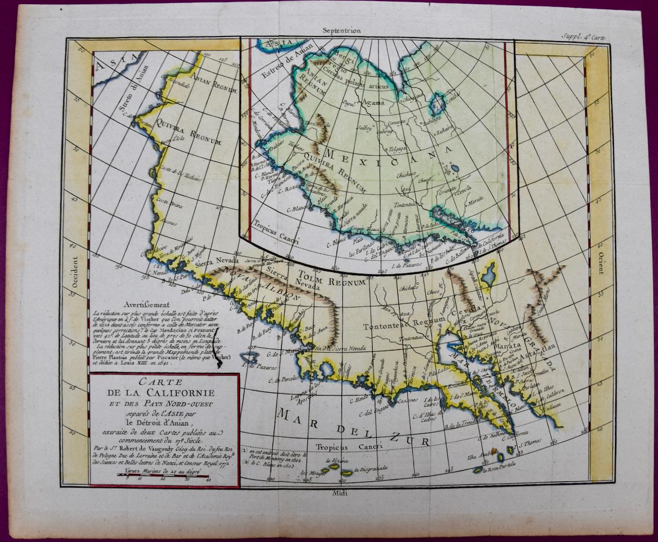
- California: 18th Century Hand-colored Map by de VaugondyBy Didier Robert de VaugondyLocated in Alamo, CAThis is an 18th century hand-colored map of the western portions of North America entitled "Carte de la Californie et des Pays Nord-Ouest separés de l'Asie par le détroit d'Anian, ex...Category
1770s Landscape Prints
MaterialsEngraving
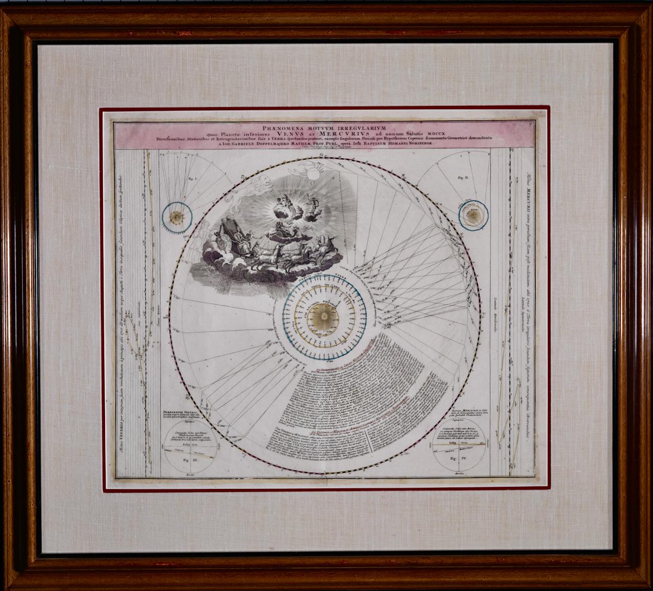
- The Orbits of Venus and Mercury: An 18th C. Framed Celestial Map by DoppelmayrBy Johann Gabriel Doppelmayr 1Located in Alamo, CAThis 18th century hand-colored copperplate celestial map by Johann Doppelmayr entitled "Phænomena Motuum Irregularium quos Planetar inferiores Venus et M...Category
Early 18th Century Landscape Prints
MaterialsEngraving
- North & South America: A 17th Century Hand-colored Map by Jansson & GoosBy Johannes JanssonLocated in Alamo, CAA 17th century hand-colored map of North & South America entitled "Americae Descriptio" by the cartographer Johannes Jansson, published in Jansson's Atlas Minor in Amsterdam in 1628....Category
1620s Landscape Prints
MaterialsEngraving
- Persia & Afghanistan: A Framed Hand-colored 17th Century Map by John CaryBy John CaryLocated in Alamo, CAThis colorful and detailed early 18th century copperplate map by John Cary entitled "A New Map of Persia from the Latest Authorities" was published in London in 1801. It depicts Persia, the region of modern day Afghanistan, the Caspian Sea, the Sea of Aral, the Persian Gulf...Category
Early 19th Century Old Masters More Prints
MaterialsEngraving
- The Normandy Region of France: A 17th C. Hand-colored Map by Sanson and JaillotBy Nicholas Sanson d'AbbevilleLocated in Alamo, CAThis large hand-colored map entitled "Le Duché et Gouvernement de Normandie divisée en Haute et Basse Normandie en divers Pays; et par evêchez, avec le Gouvernement General du Havre ...Category
1690s Landscape Prints
MaterialsEngraving
- View of Pisaro, Italy: A 16th Century Hand-colored Map by Braun & HogenbergBy Franz HogenbergLocated in Alamo, CAThis is a 16th century original hand-colored copperplate engraved map of View of Pezaro (Pisaro), Italy entitled "Pisaurum vulgo Pezaro" by Georg Braun & Franz Hogenberg, from their famous city atlas "Civitates Orbis Terrarum", published in Augsberg, Germany in 1575. The map depicts a view of Pesaro, Italy from the west looking over the town to the Adriatic Sea. The River Foglia flows into the Adriatic in the foreground. The only identifiable building is the cathedral of San Domenico, which rises above the other roofs with its tall spire. Two women, dressed in styles of the 16th century are in conversation on a hill in the foreground on the left. Pesaro is in the province of Pesaro and Urbino and lies on the Adriatic and east of Florence. The city, which was founded by the Etruscans and named Pisaurum by the Romans, belonged from AD 754 onwards to the Papal States, and after 1285 was controlled by the princely families of Malatesta, Sforza and della Rovere. Today it is the capital of the province of Pesaro and Urbino and has a population of about 92,000. Pesaro's most famous resident, composer Gioacchino Rossini, was born here in 1792. The following is an English translation of an excerpt from Braun's description of the city: "We believe that the astonishingly short life of the inhabitants of Pesaro comes not only from the insalubrious air, but also from the great quantity of delectable and delicious fruits which they consume to excess. For this causes the production in their bodies of evil humours, which then lead to incurably fatal diseases. The area around the city is most charming and well planted with vineyards, fig trees, olive trees and other fruit-bearing trees." References: Van der Krogt 4, 3369, state 1; Taschen, Braun and Hogenberg...Category
16th Century Old Masters Landscape Prints
MaterialsEngraving


You May Also Like
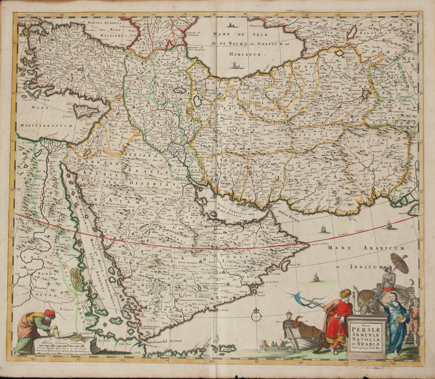
- Persiae, Armeniae, Natoliae et Arabiae Descriptio per Frederick deWit 1666 mapLocated in Paonia, COMap of Persiae, Armeniae, Natoliae et Arabiae Descriptio per F de Wit 1688 engraving from: Atlas Contractus Orbis Terrarum Praecipuas ac Novissimas Complectens Tabulas. Amsterdam, N. Visscher, 1656-77. (Koeman III, Vis5-8) This highly decorative map of the Middle East is by the Dutch engraver, publisher, and map seller...Category
1660s Realist Landscape Prints
MaterialsEngraving
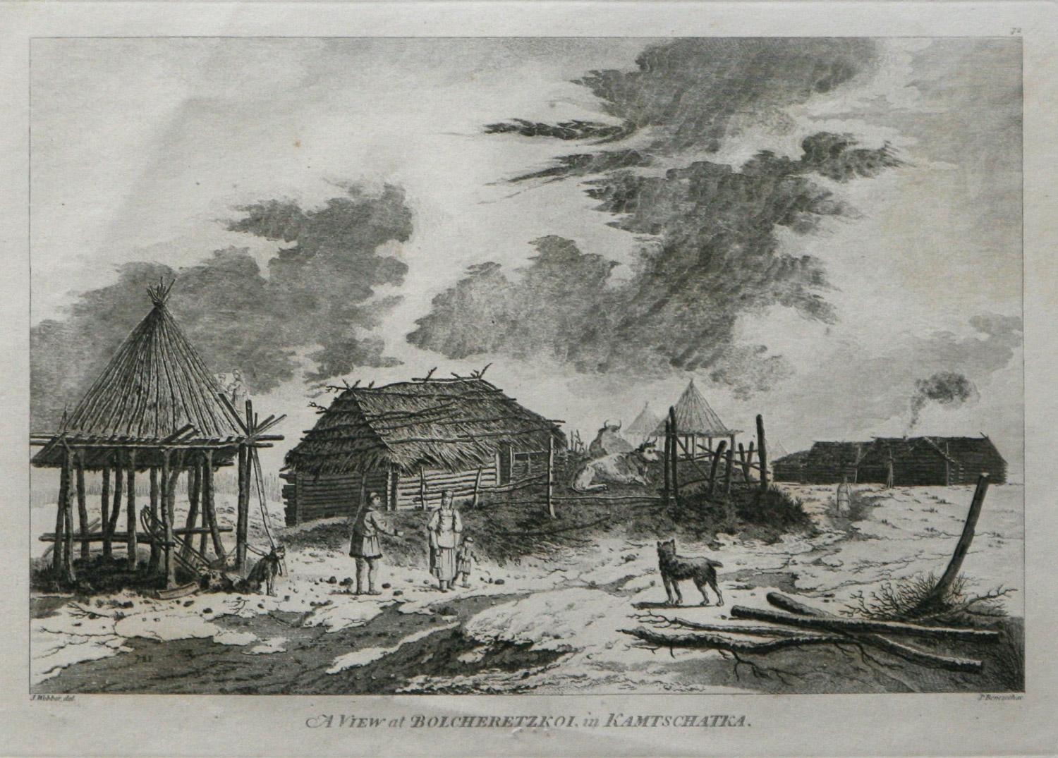
- A View at Bolcheretzko (Russia) 1784 Captains Cook Final Voyage by John WebberBy John WebberLocated in Paonia, COA View at Bolcheretzko (Russia) is from the 1784 First Edition Atlas Accompanying Capt. James Cook and King; Third and Final Voyage of Captain James Cook.John Webber (1752-1793) was ...Category
1780s Realist Landscape Prints
MaterialsEngraving
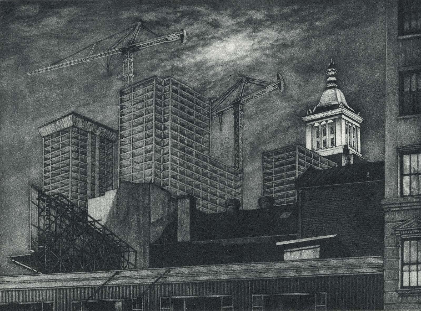
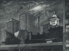
- Cranes and Concrete (in the 80s, a boom saw buildings racing into the sky?By Frederick MershimerLocated in New Orleans, LA"Cranes and Concrete" is Frederick Mershimer's mezzotint of the construction scene on Broadway between 13th and 14th streets. Mershimer is no strang...Category
1980s Contemporary Landscape Prints
MaterialsMezzotint
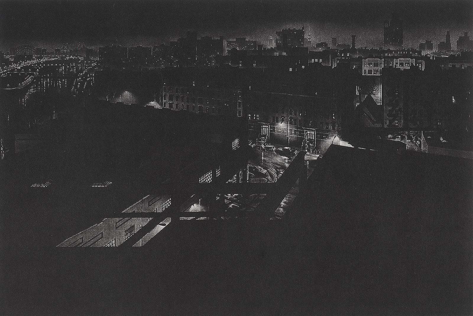
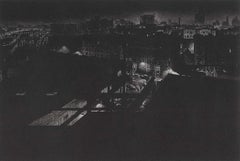
- Girders (rainy night view of artist's former studio in Washington HeightsBy Craig McPhersonLocated in New Orleans, LA"Griders" is Craig McPherson's rainy night scene showing the view from his former studio in Washington Heights in NYC. The image is the companion pi...Category
1980s Contemporary Landscape Prints
MaterialsMezzotint
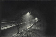
- Foggy Night (the way home or a Stephen King setting)By Carol WaxLocated in New Orleans, LAThis impression is #22 Carol Wax originally trained to be a classical musician at the Manhattan School of Music but fell in love with printmaking. Soon after she began engraving mez...Category
2010s American Modern Landscape Prints
MaterialsEngraving, Mezzotint
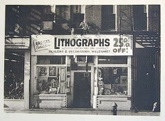
- LITHOGRAPHS Greenwich Village NYC, Signed Mezzotint, Art Gallery, PhotorealismBy John BaederLocated in Union City, NJLITHOGRAPHS Greenwich Village NYC by the American photorealist artist John Baeder is a limited edition mezzotint printed using hand printmaking techniques on archival, cream colored ...Category
1970s Photorealist Landscape Prints
MaterialsMezzotint


Recently Viewed
View AllMore Ways To Browse
Antique House Architectural Design
Antique Gold Engraving
18th C Engravings
Framed Antique French Engravings
18th Century French Landscape
Large 18th Century Landscape
French Architectural Engraving
French Engravings Architecture
18th Century Scotland
18th Century Scottish
18th C Frame Italian
Antique Architectural Plans
Antique Architecture Plan
French Baroque Architecture
British Georgian 18th Century
Baroque French Landscape
17th Century Colored Engraving
Campbell Antique