Items Similar to A NEW MAP OF THE WORLD from the Latest Observations.

Want more images or videos?
Request additional images or videos from the seller
1 of 11
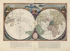
John SenexA NEW MAP OF THE WORLD from the Latest Observations. 1720s
1720s
About the Item
The title continues “…. Most Humbly Inscribd [sic] to his Royal Highness George Prince of Wales.”
A fine British produced double hemisphere world map. On this map, California is shown as an island on the main double hemisphere map and shown as a peninsula in the two smaller projections. The map has four hemispherical projections in outer corners, two zonal projections, and an armillary sphere that is flanked by Hercules and Ulysses. The title cartouche is flanked by putti and representations of the four continents. This map is in good to very good condition and nicely colored. There is a mild stain in the left margin.
John Senex (1678-1740) was an English cartographer, engraver, and explorer. He was one of the foremost mapmakers in England during the early 18th century.
- Creator:
- Creation Year:1720s
- Dimensions:Height: 20.75 in (52.71 cm)Width: 23.75 in (60.33 cm)Depth: 0.94 in (2.39 cm)
- Medium:
- Period:
- Condition:
- Gallery Location:New York, NY
- Reference Number:
About the Seller
4.6
Recognized Seller
These prestigious sellers are industry leaders and represent the highest echelon for item quality and design.
Established in 1898
1stDibs seller since 2015
51 sales on 1stDibs
Typical response time: 14 hours
Associations
International Fine Print Dealers Association
- ShippingRetrieving quote...Ships From: New York, NY
- Return PolicyA return for this item may be initiated within 14 days of delivery.
More From This SellerView All
- Nouvelle Mappe Monde, dediee au progres de nos connoissances.Located in New York, NYA handsome and well-engraved world map constructed with the prime meridian through Paris. The hemispheres are rotated through 45 degrees. This is an unusual projection for a world map and was based on the work of the French Academie Royale des Sciences. This particular impression is by Remondini who re-issued Santini's "Atlas Univ." in 1784. "Nouvelle Mappe Monde" is a copper plate engraving published by Giuseppe Remondini, Venice. The printed image size is just over 15 x 25 inches. Overall the map is in good condition with three small tears at the paper edge - all repaired. Modern (not 18th...Category
18th Century Other Art Style More Prints
MaterialsWatercolor, Engraving
- Indiarum Occidentalium Tractus Littorales cum Insulis Caribicis / Pascaert van WBy Louis RenardLocated in New York, NYThis early 18th-century engraved map was published by Louis Renard in Amsterdam. The image size is 19 x 22 " (48.3 x 55.9 cm) plus margins. A beautifully engraved Dutch sea chart. Shown is the entire Caribbean basin including the eastern seaboard up to Cape Cod and includes Bermuda. Florida is shown with the classic flattened southeastern coast that was derived by Hessel Gerritz. Noted are the routes taken by the Spanish treasure...Category
18th Century Other Art Style More Prints
MaterialsEngraving
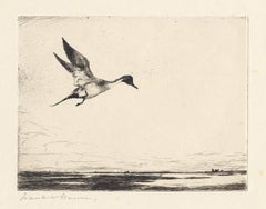
- Lone Pintail.By Frank BensonLocated in New York, NYThis drypoint from 1930 was printed in an edition of 150. It is signed in pencil just under the image in the lower left. Listed in the catalogue raisonne on Frank W. Benson by Adam Paff #303. Frank Weston Benson (1862-1951), well known for his American impressionist paintings, produced an incredible body of prints - etchings, drypoints, and a few lithographs. Born and raised on the North Shore of Massachusetts, Benson, a natural outdoorsman, grew up sailing, fishing, and hunting. While a teenager his fascination with drawing and birding developed simultaneously and continued throughout his life. His first art instruction was with Otto Grundman at the Museum of Fine Arts in Boston, and then in 1883 in Paris at the Academie Julian where he studied the rigorous ‘ecole des beaux arts’ approach to drawing and painting for two years. During the early 1880’s Seymour Haden visited Boston giving a series of lectures on etching. This introduction to the European etching...Category
1930s American Realist More Prints
MaterialsDrypoint
- Planiglobii Terrestris Mappa Universalis / Mappe MondeBy Homann HeirsLocated in New York, NYThis map was printed from a copperplate engraving in 1746. The printed image size is 18.25 x 21.75 inches (46.3 x 55.2 cm) plus margins. An attractive double hemisphere map...Category
18th Century Other Art Style More Prints
MaterialsEngraving
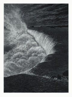
- NiagaraBy Frederick MershimerLocated in New York, NYNIAGARA Contemporary artist Frederick Mershimer created the mezzotint engraving entitled “Niagara” in 2021. This impression is signed, titled, dated, and inscribed “5/45”- the 5th ...Category
21st Century and Contemporary American Realist Landscape Prints
MaterialsMezzotint
- CrossingsBy Frederick MershimerLocated in New York, NYCROSSINGS Contemporary artist Frederick Mershimer created the mezzotint engraving entitled "Crossings" in 1998. This impression is signed, titled, and dated in pencil. The printed ...Category
Late 20th Century American Realist Landscape Prints
MaterialsMezzotint


You May Also Like
- Alphabet Letter "K"Located in Florham Park, NJAn Alphabet of Capital Letters: Selected from the Illuminations of Italian Chorale Books of the Fifteenth and Sixteenth Centuries. Arundel Society. London, 1862. Engraving. Printed...Category
1860s Academic More Prints
MaterialsGold
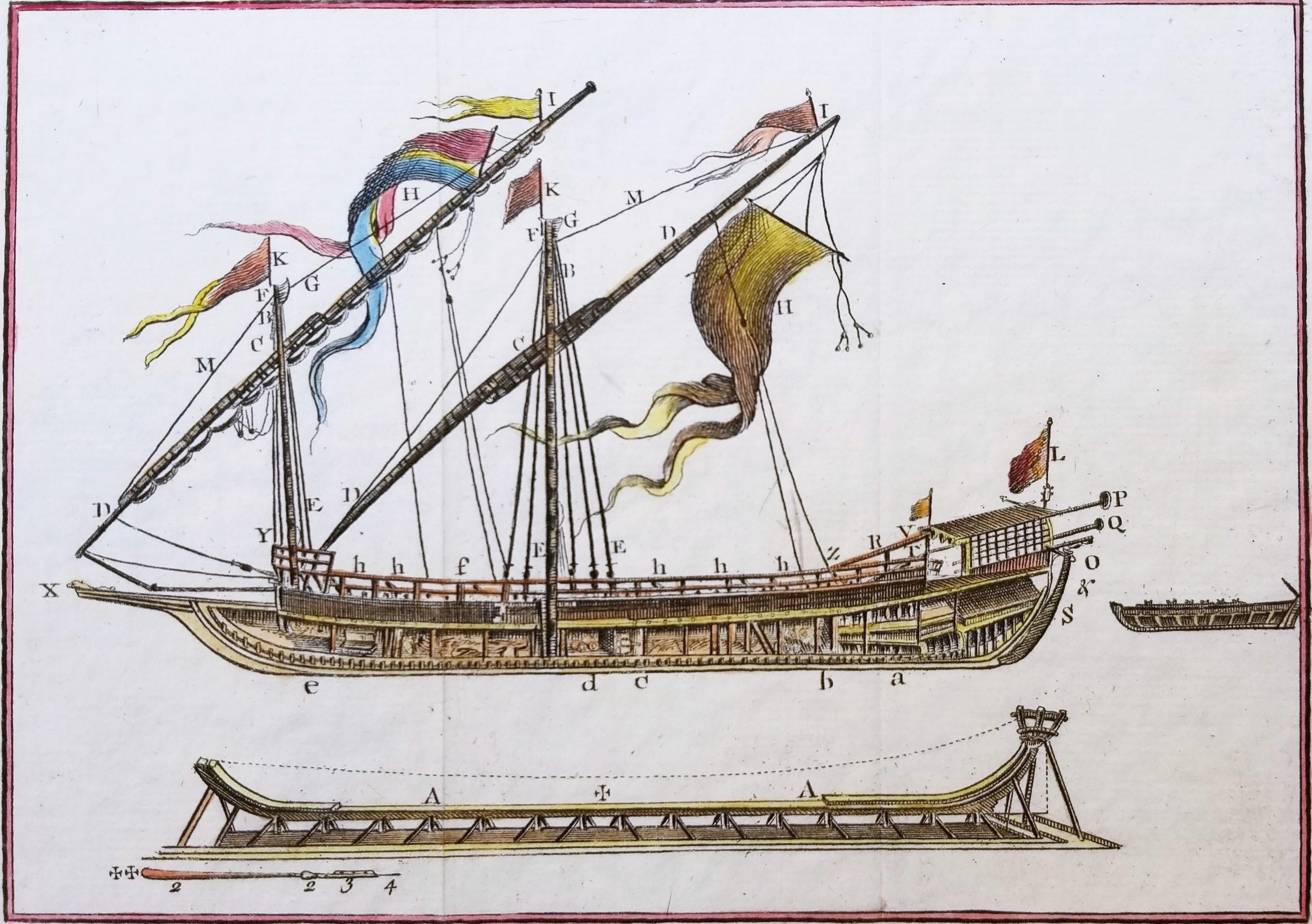
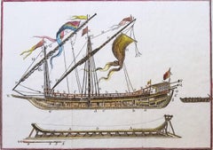
- Draught of a Galley /// Old Masters Ship Boat Seascape Construction Diagram ArtBy William Henry TomsLocated in Saint Augustine, FLArtist: William Henry Toms (English, c.1700-1765) Title: "Draught of a Galley" (Plate 13, Vol. III, page 131) Portfolio: La Spectacle de la Nature Year: 1737 Medium: Original Hand-Colored Engraving on laid paper Limited edition: Unknown Printer: Unknown, London, UK Publisher: Humphreys, London, UK Framing: Recently framed in a Regency style gold moulding with rag matting from Holland and museum glass. The frame is an antique frame we've reused, originally built by Knoedler Gallery, New York, NY Framed size: 10.25" x 10.25" Sheet size (irregular margins): 6.63" x 8.25" Image size: 4.75" x 6.75" Condition: In excellent condition with strong colors and good margins Rare Notes: Comes from the 1737 volume edition of Noël-Antoine Pluche's "La Spectacle de la Nature", translated from the original French by Humphreys as "Nature Displayed". With two soft vertical folds within paper as issued. Various dealer reference numbers and an old price pencil inscribed in margins and on verso. Biography: William Henry Toms (c. 1700–1765) was an English engraver. He worked on portraits, book-plates, landscapes and prints of buildings. Among his works were the plates for Robert West's "Perspective Views of All the Ancient Churches in London" (1736–1739). In 1741, he worked with Thomas Badeslade on "Chorographia Britanniae or a New Set of Maps of all the Counties in England and Wales". The maps were republished on 29 September 1742, with additional place names. Among Toms's apprentices was the engraver and publisher John Boydell. W. H. Toms lived in Masham Street, London, and was the father of the painter Peter Toms. Toms died in 1765. Noël-Antoine Pluche (1688-1761) , known as the abbé Pluche, was a French priest...Category
1730s Baroque More Prints
MaterialsWatercolor, Laid Paper, Engraving, Intaglio
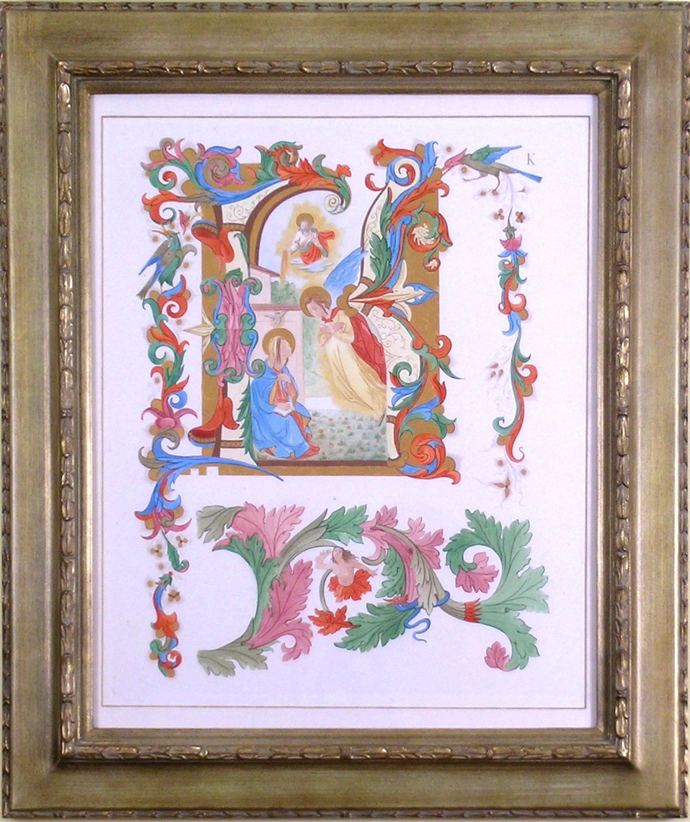
- Alphabet Letter "K" Religious SaintLocated in Florham Park, NJAn Alphabet of Capital Letters: Selected from the Illuminations of Italian Chorale Books of the Fifteenth and Sixteenth Centuries. Arundel Society. London, 1862. Engraving. Printed...Category
1860s Academic More Prints
MaterialsGold
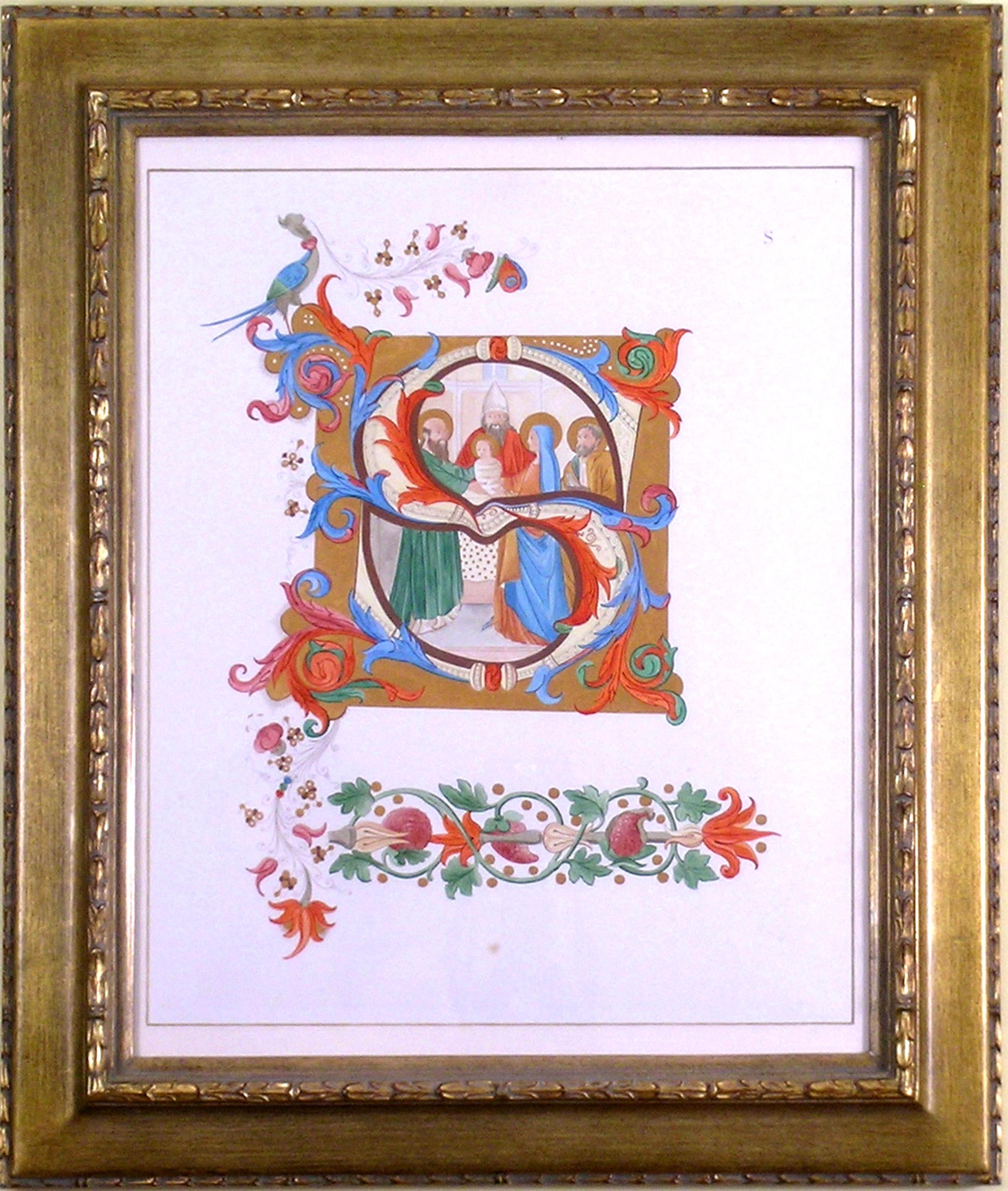
- Alphabet Letter "S", Saint, ReligiousLocated in Florham Park, NJAn Alphabet of Capital Letters: Selected from the Illuminations of Italian Chorale Books of the Fifteenth and Sixteenth Centuries. Arundel Society. London, 1862. Engraving. Printed...Category
1860s Academic More Prints
MaterialsGold
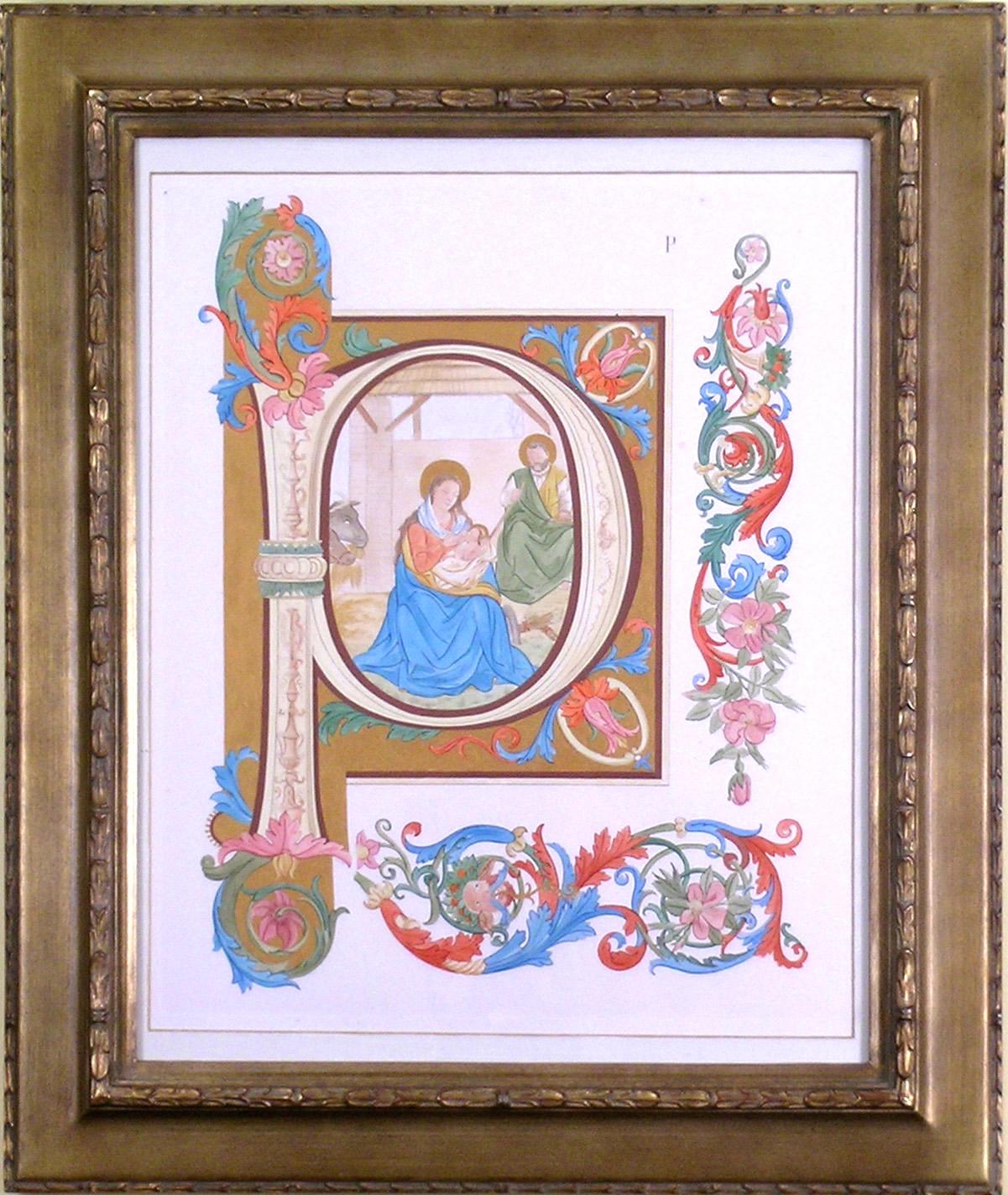
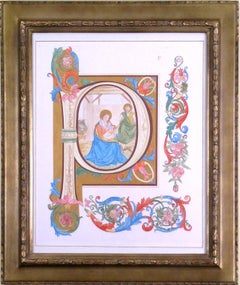
- Alphabet Letter "P"Located in Florham Park, NJAn Alphabet of Capital Letters: Selected from the Illuminations of Italian Chorale Books of the Fifteenth and Sixteenth Centuries. Arundel Society. London, 1862. Engraving. Printed in Colours. Hand-Painted Gold Highlights. To produce a study for an historic illumination of antiphonals, the Arundel Society selected each of the alphabet letters from chorale books created in the fifteenth and sixteenth centuries. Devotional pieces, the chorale music was greatly appreciated by Christians throughout the world. Often it was sung as responsive music where the choir would be divided into two parts thus creating a harmony which reinforced the Christian religious doctrine. As illustrious as the music, the key letters that headed each piece would take their own place in the art world. Many initials would be specifically devoted to prominent men and woman of both religious and cultural importance. For example, the “F” was devoted to Fra Angelico, an Italian painter of the Early Renaissance, described by Vasari in his Lives of the Artists...Category
1860s Academic More Prints
MaterialsGold
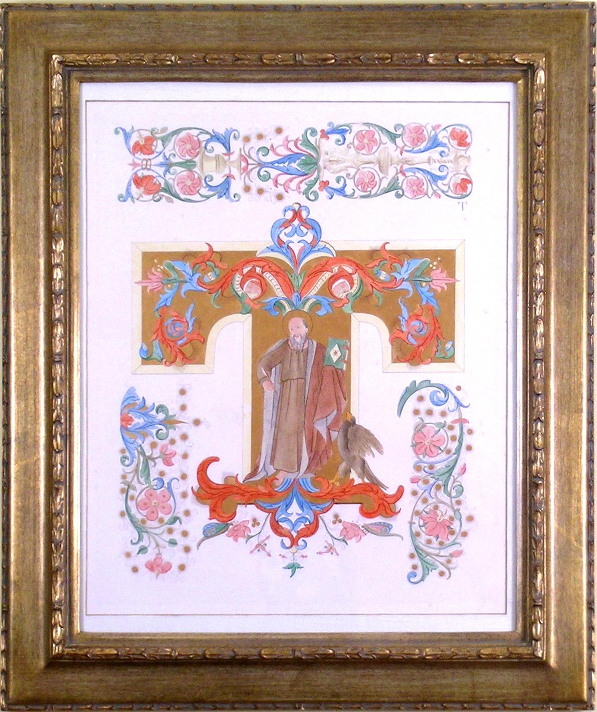
- Alphabet Letter "T"Located in Florham Park, NJAn Alphabet of Capital Letters: Selected from the Illuminations of Italian Chorale Books of the Fifteenth and Sixteenth Centuries. Arundel Society. London, 1862. Engraving. Printed...Category
1860s Academic More Prints
MaterialsGold


Recently Viewed
View AllMore Ways To Browse
Map Of The World
Antique Maps Of The World
Early 18th Century New England
California Map
Antique Map New England
Antique Map Of New England
Antique Maps New England
Hemispheres Map
Antique Maps Wales
Antique Maps Of Wales
Antique Hemisphere Maps
Antique Map California
Antique Map Of California
Antique Maps California
Antique Maps Of California
Hemisphere World Map
California Island Map
California As An Island Map