Items Similar to Antique Map of the World by Ferrario '1831'


Want more images or videos?
Request additional images or videos from the seller
1 of 6
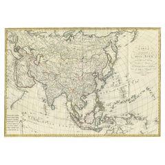
Antique Map of the World by Ferrario '1831'
About the Item
Original antique map of the world. This print originates from 'Costume Antico e Moderno: Palestine, China, India, Oceania' by Ferrario. Published 1831.
- Dimensions:Height: 9.45 in (24 cm)Width: 13.39 in (34 cm)Depth: 0.02 in (0.5 mm)
- Materials and Techniques:
- Period:
- Date of Manufacture:1831
- Condition:General age-related toning. Shows foxing. Minor wear and creasing, blank verso. Please study image carefully.
- Seller Location:Langweer, NL
- Reference Number:
About the Seller
5.0
Platinum Seller
These expertly vetted sellers are 1stDibs' most experienced sellers and are rated highest by our customers.
Established in 2009
1stDibs seller since 2017
1,965 sales on 1stDibs
Typical response time: <1 hour
- ShippingRetrieving quote...Ships From: Langweer, Netherlands
- Return PolicyA return for this item may be initiated within 14 days of delivery.
More From This SellerView All
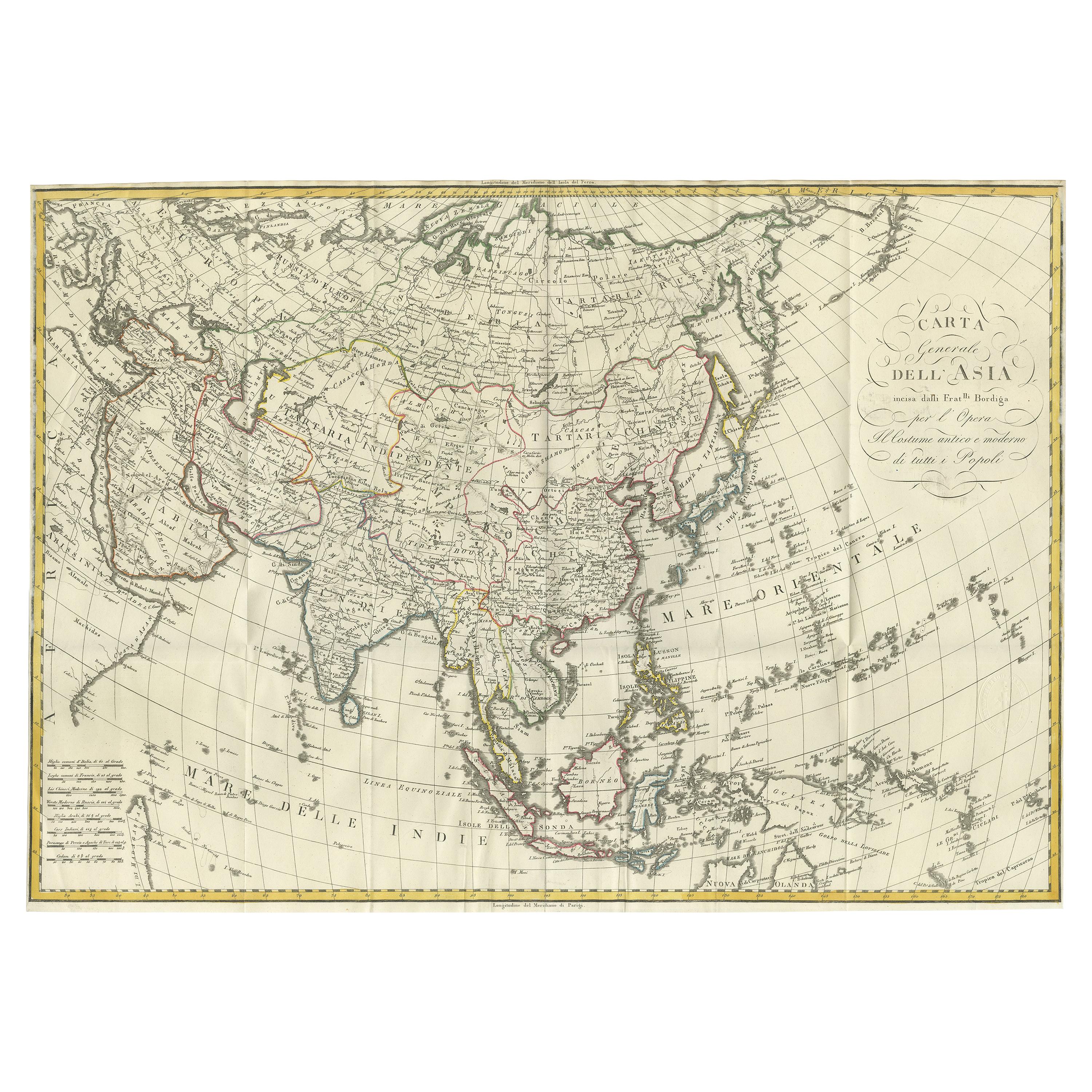
- Antique Map of Asia by Ferrario '1815'Located in Langweer, NLAntique map titled 'Carta generale dell' Asia (..)'. Original antique map of Asia. This map originates from ' Le Costume Ancien et Moderne' by Jule...Category
Antique Early 19th Century Maps
MaterialsPaper
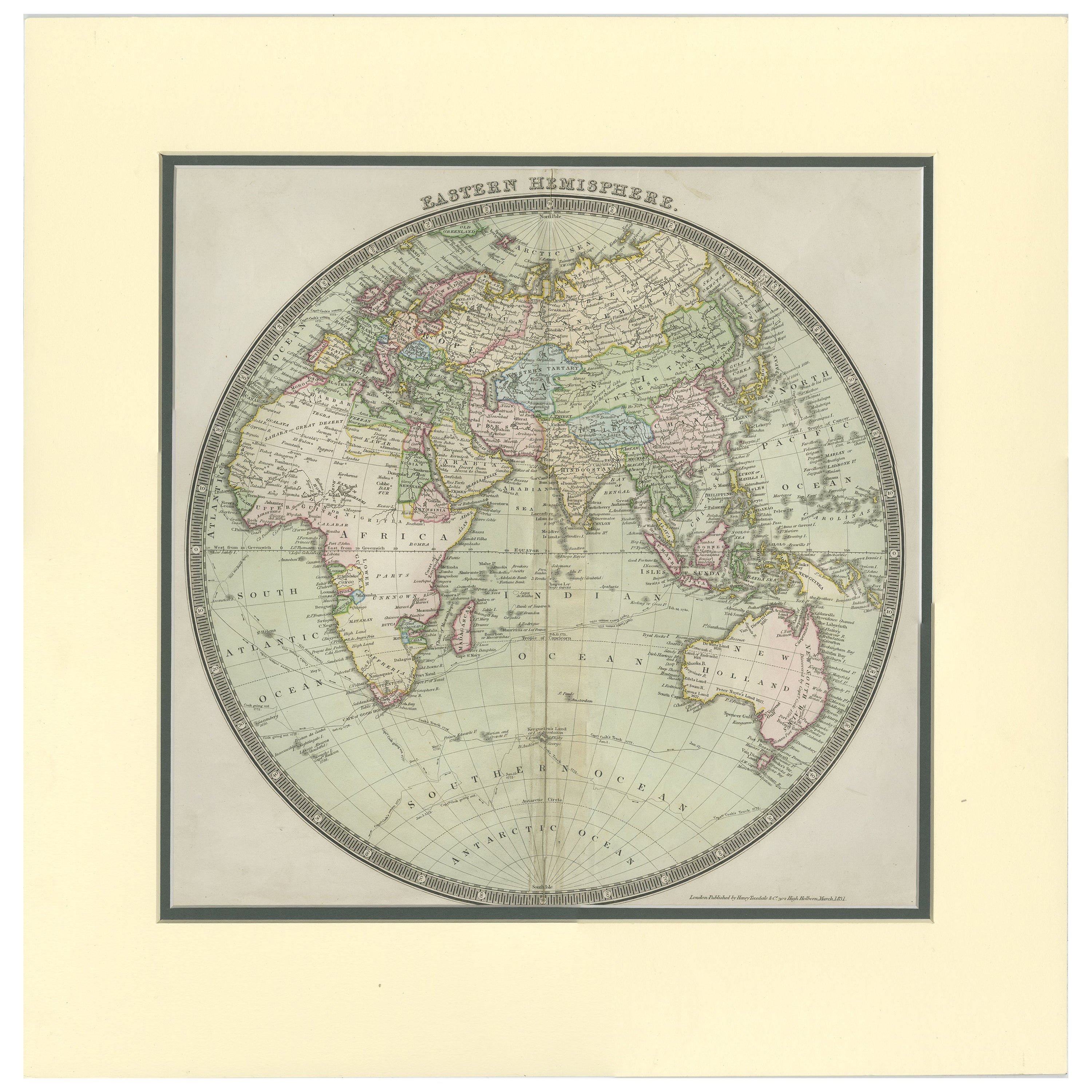
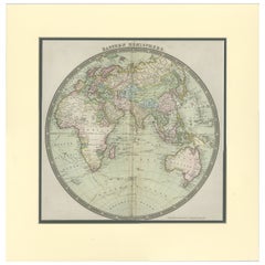
- Antique Map of the Eastern Hemisphere by Teesdale, '1831'Located in Langweer, NLAntique map titled 'Eastern Hemisphere'. Hemispherical map of eastern hemisphere showing tracks of the navigators James Cook and John Gore. Plate 1 fro...Category
Antique Mid-19th Century Maps
MaterialsPaper
- Antique Map of the World by Johnson, '1872'Located in Langweer, NLAntique map titled 'Johnson's World. Original world map. This map originates from 'Johnson's New Illustrated Family Atlas of the World' by A.J. John...Category
Antique Late 19th Century Maps
MaterialsPaper
- Antique Map of the World by Balbi '1847'Located in Langweer, NLAntique map titled 'Planisphère'. Original antique map of the world. This map originates from 'Abrégé de Géographie (..)' by Adrien Balbi. Pub...Category
Antique Mid-19th Century Maps
MaterialsPaper
- Antique Map of the World by A. Vuillemin, 1854By Victor LevasseurLocated in Langweer, NLThis map originates from ‘Atlas National de la France Illustré’. Published by A. Combette, Paris, 1854.Category
Antique Mid-19th Century Maps
MaterialsPaper
- Antique Map of the World by D'Urville '1853'Located in Langweer, NLAntique map titled 'Voyage Autour du Monde'. Original map of the world. This map originates from volume 1 of 'Voyage Autour du Monde' by Comte-Amiral Dumont D'Urville.Category
Antique Mid-19th Century Maps
MaterialsPaper


You May Also Like
- Original Antique Map of The World by Thomas Clerk, 1817Located in St Annes, LancashireGreat map of The Eastern and Western Hemispheres On 2 sheets Copper-plate engraving Drawn and engraved by Thomas Clerk, Edinburgh. Published by Mackenzie And Dent, 1817 ...Category
Antique 1810s English Maps
MaterialsPaper
- Original Antique Map of The Netherlands, Engraved by Barlow, Dated 1807Located in St Annes, LancashireGreat map of Netherlands Copper-plate engraving by Barlow Published by Brightly & Kinnersly, Bungay, Suffolk. Dated 1807 Unframed.Category
Antique Early 1800s English Maps
MaterialsPaper
- Map of the Republic of GenoaLocated in New York, NYFramed antique hand-coloured map of the Republic of Genoa including the duchies of Mantua, Modena, and Parma. Europe, late 18th century. Dimension: 25...Category
Antique Late 18th Century European Maps
- Antique Map of Italy by Andriveau-Goujon, 1843By Andriveau-GoujonLocated in New York, NYAntique Map of Italy by Andriveau-Goujon, 1843. Map of Italy in two parts by Andriveau-Goujon for the Library of Prince Carini at Palazzo Carini i...Category
Antique 1840s French Maps
MaterialsLinen, Paper
- Antique Map of Principality of MonacoBy Antonio Vallardi EditoreLocated in Alessandria, PiemonteST/619 - "Old Geographical Atlas of Italy - Topographic map of ex-Principality of Monaco" - ediz Vallardi - Milano - A somewhat special edition ---Category
Antique Late 19th Century Italian Other Prints
MaterialsPaper
- Original Antique Map of Russia By Arrowsmith. 1820Located in St Annes, LancashireGreat map of Russia Drawn under the direction of Arrowsmith Copper-plate engraving Published by Longman, Hurst, Rees, Orme and Brown, 1820 Unframed.Category
Antique 1820s English Maps
MaterialsPaper


Recently Viewed
View AllMore Ways To Browse
Palestine Map
Antique Map Palestine
Thomas Owen
Tiber Press
Tom Tru
Used Furniture Erie Pa
Vertes Dancing
Weed Lithograph
1st Dibbs
Acipenser Sturio
Antique Furniture Bunbury
Art Deco Revival Framed Art Prints
Au Baiser Avignon
Bearded Vulture
Cabral Garcia
Carolina Parrots
Cesar Daly
Copper Plate Engraving By Giovanni Battista Piranesi