Items Similar to Northern Italy: A 16th Century Hand-colored Map by Abraham Ortelius


Want more images or videos?
Request additional images or videos from the seller
1 of 16
Abraham OrteliusNorthern Italy: A 16th Century Hand-colored Map by Abraham Ortelius1584
1584
About the Item
This is a framed 16th century hand-colored copperplate map of northern Italy entitled "Veronae Urbis Territorium a Bernardo Bragnolo Descriptium" by Abraham Ortelius from his atlas "Theatrum Orbis Terrarum", which was the first modern atlas of the world, with the first volume published in 1570. This map was part of a subsequent volume, published in Antwerp in 1584. It was based on an earlier map by Bernardo Brognoli.
This beautiful map of northern Italy is focussed on Verona and its environs, including Mantua. Lake Garda and the South Tyrol mountains are prominently depicted. There is a very large striking cartouche in the upper left and a decorative distance scale in the lower right.
This striking hand-colored map of northern Italy is presented in a gold-colored wood frame and an olive green-colored mat. It is glazed with UV conservation glass. All mounting materials used are archival. The frame measures 21.5" high by 28" wide by 0.75" deep. There is a central vertical fold, as issued, with slight separation of the lower portion of the fold. There are faint spots in the upper and right margins, but the map is otherwise in very good condition.
Abraham Ortelius (also known as Ortels, Orthellius, and Wortels) (1527-1598) was a Dutch cartographer, geographer, and cosmographer. He began his career as a map colorist. In 1547 he entered the Antwerp guild of St Luke as an "illuminator of maps". He had an affinity for business from an early age and most of his journeys before 1560, were for business. He was a dealer in antiques, coins, maps, and books.
His business income allowed him to acquire an extensive collection of medals, coins, and antiques, as well as a large library of books. In 1560, he travelled to Trier, Lorraine, and Poitiers with the great cartographer, Gerard Mercator. During this trip he was impressed by Mercator’s influence which inspired him to pursue a career as a scientific geographer. He rapidly became proficient at mapmaking and printing, completing his “Mappemonde", a large and ambitious eight-sheet wall map of the world in 1564. Ortelius also published a map of Egypt in 1565, a map of the Holy Land, a plan of Brittenburg Castle on the coast of the Netherlands, and a map of Asia in the late 1560's.
Ortelius went on to create the first modern atlas, the 'Theatrum Orbis Terrarum' (Theatre of the World) in 1570, which is often considered as the official beginning of the Golden Age of Netherlandish cartography. The maps were engraved by Franz Hogenberg, who himself achieved fame for his publication with Georg Braun of the 2nd atlas ever created, the 'Civitates Orbis Terrarum', focussed on views of European towns and cities. Ortellius reportedly assisted in the creation of this atlas. In 1573, Ortelius published seventeen supplementary maps under the title of 'Additamentum Theatri Orbis Terrarum'. In 1575 he was appointed geographer to the king of Spain, Philip II. By the time of Ortelius' death in 1598, a total of 25 editions of 'Theatrum Orbis Terrarum' were published, including editions in Latin, Italian, German, French, and Dutch. Ortelius is now considered one of the most famous and respected mapmakers from the golden age of Dutch cartography and printmaking, as well as academic geography. He is believed to be the first person to imagine that the continents were joined before drifting to their present positions.
References:
Van der Krogt 3, 7111:31
Van Den Broecke 120
- Creator:Abraham Ortelius (1527 - 1598, Dutch)
- Creation Year:1584
- Dimensions:Height: 21.5 in (54.61 cm)Width: 28 in (71.12 cm)Depth: 0.75 in (1.91 cm)
- Medium:
- Movement & Style:
- Period:
- Condition:
- Gallery Location:Alamo, CA
- Reference Number:
About the Seller
5.0
Platinum Seller
These expertly vetted sellers are 1stDibs' most experienced sellers and are rated highest by our customers.
Established in 2011
1stDibs seller since 2019
233 sales on 1stDibs
Typical response time: 1 hour
- ShippingRetrieving quote...Ships From: Alamo, CA
- Return PolicyA return for this item may be initiated within 7 days of delivery.
More From This SellerView All
- Meissen, Germany : A Large Framed 18th Century Map by Petrus SchenkLocated in Alamo, CAThis is a hand-colored 18th century map of the Meissen region of Germany, entitled "Geographischer Entwurff Derer Aemmter Meissen als Creys-Procuratur-Schul-und Stiffts-Ammt benebst ...Category
Mid-18th Century Old Masters Landscape Prints
MaterialsEngraving
- Persia, Armenia & Adjacent Regions: A Hand-colored 17th Century Map by De WitBy Frederick de WitLocated in Alamo, CAThis colorful and detailed 17th century copperplate map by Frederick De Wit was published in Amsterdam between 1666 and 1690. It depicts the Caspian Se...Category
Late 17th Century Old Masters More Prints
MaterialsEngraving
- View of Pisaro, Italy: A 16th Century Hand-colored Map by Braun & HogenbergBy Franz HogenbergLocated in Alamo, CAThis is a 16th century original hand-colored copperplate engraved map of View of Pezaro (Pisaro), Italy entitled "Pisaurum vulgo Pezaro" by Georg Braun & Franz Hogenberg, from their famous city atlas "Civitates Orbis Terrarum", published in Augsberg, Germany in 1575. The map depicts a view of Pesaro, Italy from the west looking over the town to the Adriatic Sea. The River Foglia flows into the Adriatic in the foreground. The only identifiable building is the cathedral of San Domenico, which rises above the other roofs with its tall spire. Two women, dressed in styles of the 16th century are in conversation on a hill in the foreground on the left. Pesaro is in the province of Pesaro and Urbino and lies on the Adriatic and east of Florence. The city, which was founded by the Etruscans and named Pisaurum by the Romans, belonged from AD 754 onwards to the Papal States, and after 1285 was controlled by the princely families of Malatesta, Sforza and della Rovere. Today it is the capital of the province of Pesaro and Urbino and has a population of about 92,000. Pesaro's most famous resident, composer Gioacchino Rossini, was born here in 1792. The following is an English translation of an excerpt from Braun's description of the city: "We believe that the astonishingly short life of the inhabitants of Pesaro comes not only from the insalubrious air, but also from the great quantity of delectable and delicious fruits which they consume to excess. For this causes the production in their bodies of evil humours, which then lead to incurably fatal diseases. The area around the city is most charming and well planted with vineyards, fig trees, olive trees and other fruit-bearing trees." References: Van der Krogt 4, 3369, state 1; Taschen, Braun and Hogenberg...Category
16th Century Old Masters Landscape Prints
MaterialsEngraving
- L'Isle de France: A Hand-colored 17th Century Map by De WitBy Frederick de WitLocated in Alamo, CAThis colorful and detailed 17th century hand-colored copperplate map by Frederick De Wit was published in Amsterdam between 1666 and 1760. The map depicts the Île-de-France, which is one of the ancient provinces of France. Paris is located in the center of the map, with Versailles to the southwest The map extends from Rouen in the west to Reims in the east. The area around Paris, the Véxin Français, was the original domain of the king of France. Other areas were ruled by French feudal lords. For example, the Véxin Normand area was the domain of the Duke of Normandy...Category
Early 18th Century Old Masters More Prints
MaterialsEngraving
- Mediterranean and Adriatic Seas: Original 18th Century Hand-colored Map by BowenLocated in Alamo, CAThis is an original 18th century hand-colored map entitled "An Accurate Chart of The Mediterranean and Adriatic Sea's; with the Archipelago & Part of the Black Sea. Exhibiting all th...Category
Mid-18th Century Old Masters Landscape Prints
MaterialsEngraving
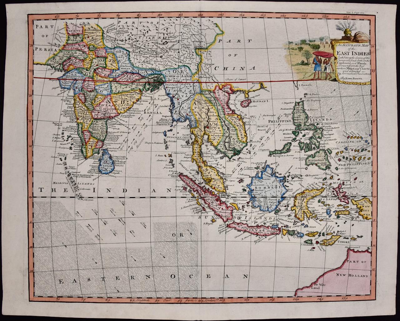
- Map of the East Indies: An Original 18th Century Hand-colored Map by E. BowenLocated in Alamo, CAThis is an original 18th century hand-colored map entitled "An Accurate Map of the East Indies Exhibiting the Course of the European Trade both on the Continent and Islands" by Emanu...Category
Mid-18th Century Old Masters Landscape Prints
MaterialsEngraving


You May Also Like
- India William Hodges 'The East End of the Fort of Mongheer' India EngravingBy William HodgesLocated in Norfolk, GBAquatint with soft ground etching from the seminal publication, Selected Views in India, drawn on the Spot, in the Years 1780, 1781, 1782 and 1783, and Executed in Aquatint in 1786 -...Category
Late 18th Century Other Art Style Landscape Prints
MaterialsEngraving
- India William Hodges 'A View of the Ravines at Etana' Early India EngravingBy William HodgesLocated in Norfolk, GBWilliam Hodges Plate 27 'A View of the Ravines at Etawa' Published 20th May 1787 by J Wells, 22 Charing Cross. Page size, 16.5” x 22.5”, image 11.25 x 18” Aquatint with soft gro...Category
Early 2000s Other Art Style Landscape Prints
MaterialsEngraving
- Hidden Cities I / second stateBy Peter MiltonLocated in New York, NY“Hidden Cities I : The Ministry. Second State.” Contemporary artist Peter Milton created this etching and engraving in 2006. The printed image size is Image size 23.50 x 36.88 inches and the paper size is 31 x 42 inches. This impression is signed, dated, and titled in pencil and inscribed “11/75” – the 11th impression from the total printing of 75. “I do love to draw. I feel that I am being granted membership in the Brotherhood of Merlin, conjuring forth some apparition. As a drawing develops, I sense a vague presence coming more and more into focus, something in a white fog emerging and becoming increasingly palpable.” – P. Milton, “The primacy of touch. The Drawings of Peter Milton” “Working in layers, Milton begins with drawings based on people and places, with nods to Western art history and culture. He is a master of the appropriated image, a term that may conjure Andy Warhol and his Pop Art comrades. But Milton steps further back in history, avoiding the Pop sense of cool advertising and popular culture references. Instead, a broader cultural past is tapped through historical photographs of key players, architecture, and locales, which he reinvents by hand. He adds content drawn from his life as an avid reader – always with multiple possible interpretations – thus incorporating deeper meaning in his cinematic worlds. Elements of Greek mythology, classical music, art history, and history coalesce in his images, which embrace the messiness, sorrow, and elation that is life. One is hard-pressed to imagine a more erudite, skilled, passionate, and cheeky soul. In addition to a storied career in printmaking, since 2007 Milton has fearlessly produced artwork digitally. He now creates images using Adobe Photoshop in files consisting of more than two thousand layers, which are printed both as digital prints on paper and, for display on Led light boxes...Category
21st Century and Contemporary American Realist Landscape Prints
MaterialsEngraving, Etching
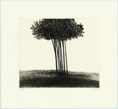
- A small copse in a field.By Robert KipnissLocated in New York, NYThe drypoint engraving entitled "A small copse in a field" was created by Robert Kipniss in 2016. Printed in an edition of 16 - this impression is signed in pencil and inscribed “12...Category
21st Century and Contemporary Modern Landscape Prints
MaterialsEngraving, Drypoint
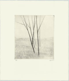
- Slope w.five treesBy Robert KipnissLocated in New York, NY“Slope w/five trees” is a drypoint engraving created by Robert Kipniss in 2020. The paper size is 12.50 x 10.50 inches and the printed image size is 6.75 x ...Category
21st Century and Contemporary Modern Landscape Prints
MaterialsEngraving, Drypoint
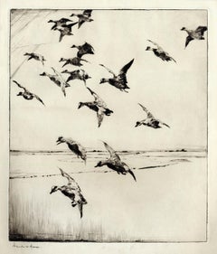
- Here They Come !By Frank W. BensonLocated in New York, NYThis impression of "Here They Come !" is from the fourth state of eight. There are six known impressions of the fourth state. Edition 150 (final state). It is signed in pencil in the lower left and inscribed "D-1". The image size 13 7/8 x 11 3/4" (34.6 x 28.8 cm) and sheet size 16 3/4 x 14 5/8" (42.8 x 37.1 cm). FRANK W. BENSON (1862-1951) Frank Weston Benson, well known for his American impressionist paintings, also produced an incredible body of prints - etchings, drypoints, and a few lithographs. Born and raised on the North Shore of Massachusetts, Benson, a natural outdoorsman, grew up sailing, fishing, and hunting. From a young age, he was fascinated with drawing and birding – this keen interest continued throughout his life. His first art instruction was with Otto Grundman at the Museum of Fine Arts in Boston, and then in 1883 in Paris at the Academie Julian where he studied the rigorous ‘ecole des beaux arts’ approach to drawing and painting for two years. During the early 1880’s Seymour Haden visited Boston giving a series of lectures on etching. This introduction to the European etching...Category
1920s American Impressionist More Prints
MaterialsDrypoint
Recently Viewed
View AllMore Ways To Browse
Northern Italy
16th Century And Earlier
16th Italian
Old Antique Scales
Old Scales Antique
Old Antique Scale
Old Antique Scales Scales
16th Century Hand Art
16th Gold
Spain Old Masters
Old Spanish Master
16th Century Gold
16th Century German
Dutch 16th
Italian Late 16th Century
16th Century Dutch
Antique Italian Old Masters
Antique Print 16th Century