Items Similar to West Germany: Original Hand Colored 17th Century Map by Johannes Janssonius


Want more images or videos?
Request additional images or videos from the seller
1 of 9
Johannes JanssoniusWest Germany: Original Hand Colored 17th Century Map by Johannes Janssonius1640
1640
About the Item
An original hand colored copperplate engraved map entitled in Latin "Archiepiscopatus Maghdeburgensis et Anhaltinus Ducatus cum terris adjacentibus", published in Amsterdam in 1640 in the atlas "Theatrum orbis terrarum, sive, Atlas novus" by Johannes Janssonius. It includes the 17th century region of the Archbishopric of Magdeburg, and the Duchy of Anhalt in West Germany.
This attractive and colorful map with its beautiful cartouche has a central fold, as issued. There is minimal color offset in the upper portions of the map from the opposite side, resulting from the map having been folded in the atlas for an extended period of time, perhaps centuries. There are large full margins. There are spots in the periphery of the margins, but none are seen in the map. The map is presented in an off-white mat with a mylar window. It is hinged at the top only. The map measures 21" x 24.5" and the mat measures 27.5" x 30".
Johannes Janssonius (c. 1588-1664) was born into a family of printers and publishers who schooled him in the book printing trade as a child. In 1612 he married the daughter of Jodocus Hondius, one of the greatest cartographers and printers in history. Janssonius was now a member of one of the most important publishing families in the Netherlands. During the 1630s he went into partnership with his brother-in-law Henricus Hondius and published more editions of the Mercator/Hondius atlases with the addition of the name Jansson. He was responsible for expanding their company publishing several world and city atlases in competition with the Blaeu publishing family. Jansson's most prominent works include the "Atlas Novus" (1638), the "Atlas Majoris Appendix" (1639) and his huge eleven volume "Atlas Major" (1647).
- Creator:Johannes Janssonius (1588 - 1664, Dutch)
- Creation Year:1640
- Dimensions:Height: 21 in (53.34 cm)Width: 24.5 in (62.23 cm)
- Medium:
- Movement & Style:
- Period:Mid-17th Century
- Condition:
- Gallery Location:Alamo, CA
- Reference Number:
About the Seller
5.0
Platinum Seller
These expertly vetted sellers are 1stDibs' most experienced sellers and are rated highest by our customers.
Established in 2011
1stDibs seller since 2019
230 sales on 1stDibs
Typical response time: 1 hour
- ShippingRetrieving quote...Ships From: Alamo, CA
- Return PolicyA return for this item may be initiated within 7 days of delivery.
More From This SellerView All
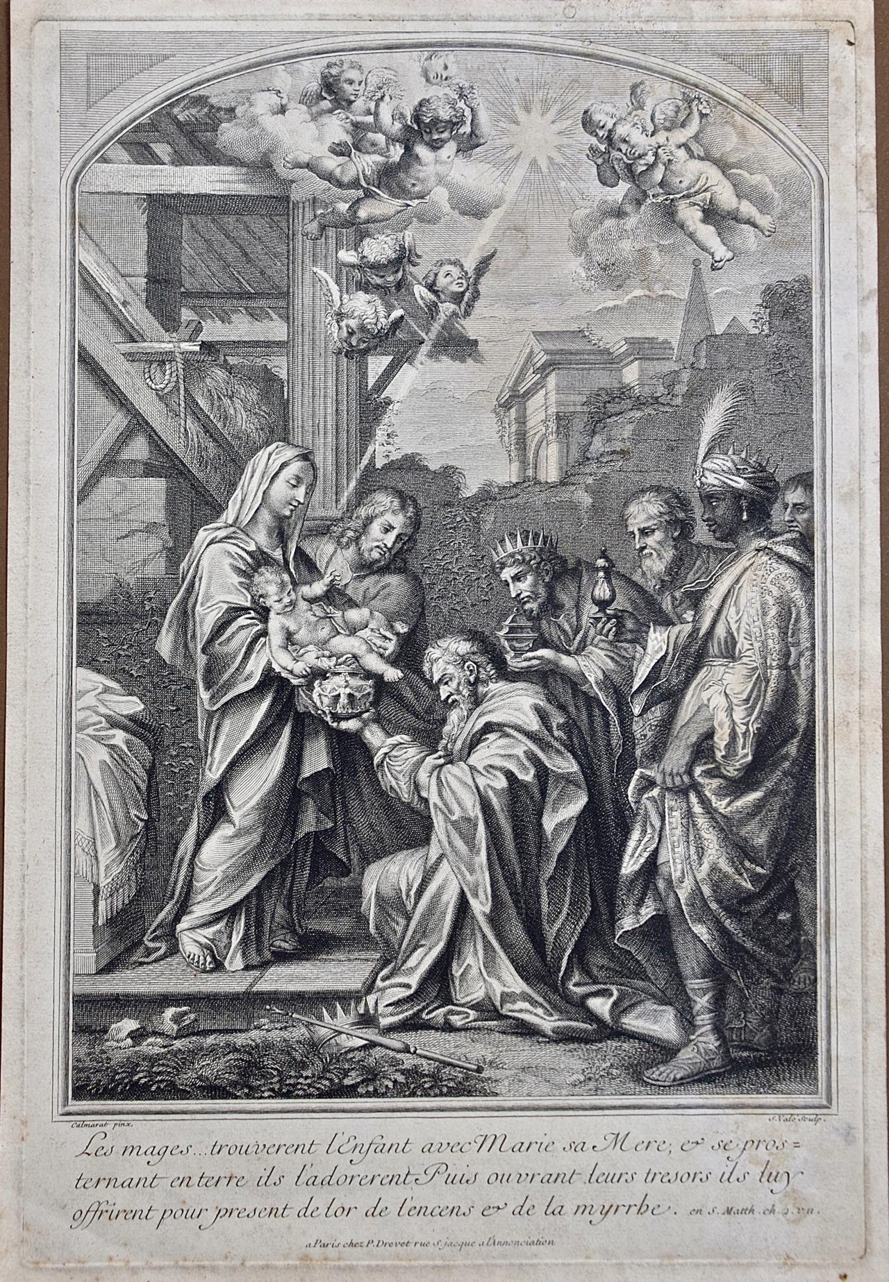
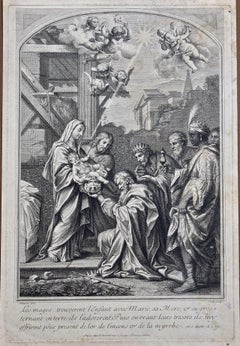
- The Gift of the Magi: An 18th C. Religious Engraving by Vale, After CalmaratLocated in Alamo, CAThis is a very rare early 18th century old master religious themed engraving entitled "Les Mages...Trouverent l'Enfant avec Marie sa Mere, et se prosternant entere ils l'adorent Puis ouvrant leurs tresors ils tuy offrirent pour present de lor de l'encens et de la myrrhe" by S. Vale after Calmaret, published in Paris by Pierre Drevet (1663-1738). The scene depicts the Magi bowing before Jesus, who is held by his mother Mary, and bringing him gifts of gold, frankincense and myrrh to demonstrate their adoration and respect. Winged cherubs fly overhead and a ray of light is focused on the spiritual couple. A cattle stall and buildings are in the background and a crown and scepter are dropped in the foreground, symbolically demonstrating that these nobles place Jesus above their titles and rank. Little is known about the artist Calmarat or the engraver S...Category
Early 18th Century Old Masters Portrait Prints
MaterialsEngraving
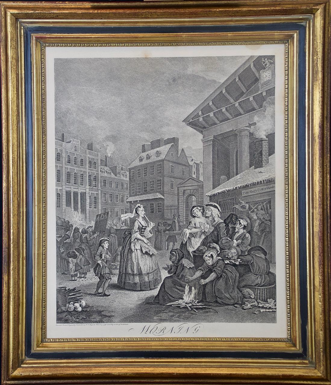
- Four Framed Hogarth Engravings "Four Times of the Day"By William HogarthLocated in Alamo, CAThe four plates in this "Four Times of the Day" set were created utilizing both engraving and etching techniques by William Hogarth in 1738. Hogarth's original copper plates were refurbished where needed by James Heath and these engravings were republished in London in 1822 by Braddock, Cradock & Joy. This was the last time Hogarth's original copper plates were used for printing. Most were melted down during World War I for the construction of bombs. Printed upon early nineteenth century wove paper and with large, full margins as published by William Heath in 1822. The inscription below each print reads "Invented Painted & Engraved by Wm. Hogarth & Publish'd March 25. 1738 according to Act of Parliament". These large folio sized "Four Times of the Day" engravings/etchings are presented in complex gold-colored wood frames with black bands and scalloped gold inner trim. A majority of each thick impressive frame is covered with glass applied near the outer edge. Each frame measures 25.75" high, 22.25" wide and 1.88" deep. There are a few small dents in the edge of these frames, which are otherwise in very good condition. "Morning" has two focal areas of discoloration in the upper margin and some discoloration in the right margin, a short tear in the left margin and a short tear or crease in the right margin. "Noon" has a spot in the upper margin that extends into the upper image, but it is otherwise in very good condition. "Evening" has a faint spot in the upper margin, but it is otherwise in very good condition. "Night" is in excellent condition. The "Four Times of the Day" series is in the collection of many major museums, including: The British Museum, The Metropolitan Museum of Art, The Tate Museum, The Chicago Art Institute and The Victoria and Albert Museum. Through this series Hogarth is portraying early 18th century London street life at "Four Times of the Day". His characters are exhibiting their personalities, quircks, strange activities, but he also wants to draw attention the disparities between the wealthy aristocracy and the common working class. Plate 1, "Morning" depicts morning in Covent Garden in the winter in front of Tom King...Category
Mid-18th Century Old Masters Landscape Prints
MaterialsEngraving, Etching
- Canterbury: An Original 16th C. Framed Hand-colored Map by Braun & HogenbergBy Franz HogenbergLocated in Alamo, CAThis is a framed 16th century map and city view of Canterbury, England entitled "Cantuarbury" by Braun & Hogenburg, from their famous landmark atlas of city views 'Civitates Orbis Terrarum' (Atlas of the Cities of the World), which was first published in Cologne, Germany in 1572. The map of Canterbury was first published in 1588. It depicts a detailed birdseye view of the completely walled and fortified city of Canterbury, with its cathedral the most prominent feature. The coat of arms of England, Canterbury, and the Archbishop of Canterbury are included. This beautifully hand-colored map is presented in a gold-colored wood frame with a beaded inner trim and a paprika-colored mat that highlights details in the map. The frame measures 18.75" high by 22.25" wide by 0.875" deep. There is a central vertical fold, as issued. The map is in excellent condition. Braun and Hogenberg's 'The Civitates Orbis Terrarum' was the second atlas of maps ever published and the first atlas of cities and towns of the world. It is one of the most important books published in the 16th century. Most of the maps in the atlas were engraved by Franz Hogenberg and the text, with its descriptions of the history and additional factual information of the cities, was written by a team of writers and edited by Georg Braun. The work contained 546 bird-eye views and map views of cities and towns from all over the world. It gave graphic representation of the main features of the illustrated cities and towns, including the buildings and streets. Although the ordinary buildings are stylized, the principal buildings are reproduced from actual drawings created on location. The principal landmarks and streets can still be recognized today. In addition, the maps often include the heraldic arms of the city, the nature of the surrounding countryside, the important rivers, streams and harbors, even depicting stone bridges, wooden pontoons, flat-bottomed ferries, ships and working boats, wharves and jetties, as well as land-based activities, including horsemen, pedestrians, wagons, coaches, and palanquins. Small vignettes are often included which illustrate the trade, occupations and habits of the local inhabitants, such as agriculture, paper-making and textiles, as well as local forms of punishment, such as gibbets, wheels, floggings etc. Large figures dressed in their local costume are often presented out of proportion in the foreground. The aim of the authors was to give as much information as possible in a pleasing visual form. They succeeded in creating maps that were both informative and decorative works of art. The atlas is a wonderful glimpse of life in medieval Europe. Georg Braun (1541-1622) was German Catholic...Category
16th Century Old Masters Landscape Prints
MaterialsEngraving
- Meissen, Germany : A Large Framed 18th Century Map by Petrus SchenkLocated in Alamo, CAThis is a hand-colored 18th century map of the Meissen region of Germany, entitled "Geographischer Entwurff Derer Aemmter Meissen als Creys-Procuratur-Schul-und Stiffts-Ammt benebst ...Category
Mid-18th Century Old Masters Landscape Prints
MaterialsEngraving
- Northern Italy: A 16th Century Hand-colored Map by Abraham OrteliusBy Abraham OrteliusLocated in Alamo, CAThis is a framed 16th century hand-colored copperplate map of northern Italy entitled "Veronae Urbis Territorium a Bernardo Bragnolo Descriptium" by Abraham Ortelius from his atlas "Theatrum Orbis Terrarum", which was the first modern atlas of the world, with the first volume published in 1570. This map was part of a subsequent volume, published in Antwerp in 1584. It was based on an earlier map by Bernardo Brognoli. This beautiful map of northern Italy is focussed on Verona and its environs, including Mantua. Lake Garda and the South Tyrol mountains are prominently depicted. There is a very large striking cartouche in the upper left and a decorative distance scale in the lower right. This striking hand-colored map of northern Italy is presented in a gold-colored wood frame and an olive green-colored mat. It is glazed with UV conservation glass. All mounting materials used are archival. The frame measures 21.5" high by 28" wide by 0.75" deep. There is a central vertical fold, as issued, with slight separation of the lower portion of the fold. There are faint spots in the upper and right margins, but the map is otherwise in very good condition. Abraham Ortelius (also known as Ortels, Orthellius, and Wortels) (1527-1598) was a Dutch cartographer, geographer, and cosmographer. He began his career as a map colorist. In 1547 he entered the Antwerp guild of St Luke as an "illuminator of maps". He had an affinity for business from an early age and most of his journeys before 1560, were for business. He was a dealer in antiques, coins, maps, and books. His business income allowed him to acquire an extensive collection of medals, coins, and antiques, as well as a large library of books...Category
16th Century Old Masters Landscape Prints
MaterialsEngraving
- Frankfort, Germany: A 16th Century Hand-colored Map by Braun & HogenbergBy Franz HogenbergLocated in Alamo, CAThis is a 16th century original hand-colored copperplate engraved map of Frankfort, Germany entitled "Francenbergum, vel ut alij Francoburgum Hassiae Opp" by Georg Braun & Franz Hogenberg, from their famous city atlas "Civitates Orbis Terrarum", published in Cologne, Germany in 1595. This is an English translation of an excerpt from the original text in the atlas: "Frankenberg or, according to others, Francoburgum, a town in Hesse. Charlemagne vested the town of Frankenberg with many freedoms and privileges, which it still enjoys to this day, and on account of its valiant and victorious soldiers awarded a signet, upon which there formerly appeared a golden castle with a tower, together with the letter F and a golden crown. Frankenberg, seen here from the northeast, lies on a hill above the River Eder. The hillside is covered with fields neatly separated by bushes and fences. Soaring above the town is the massive Liebfrauenkirche, which was modelled on St Elizabeth's church in Marburg. The New Town was founded in 1335 at the foot of the hill (right) and merged with the Old Town as late as 1556. Frankenberg was founded by Conrad of Thuringia in 1233/34 to prevent the archbishops of Mainz from expanding their sphere of influence...Category
16th Century Old Masters Landscape Prints
MaterialsEngraving


You May Also Like
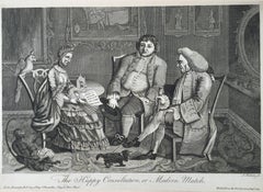
- The Happy Consultation, or Modern MatchLocated in Santa Monica, CAEIGHTEENTH CENTURY BRITISH CARICATURE THE HAPPY CONSULTATION, or MODERN MATCH, 1769 (DG 4335) ...Category
1760s Old Masters More Prints
MaterialsEngraving
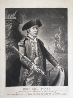
- John Paul Jones Commander of a Squadron - 13 Colonies United States...Located in Santa Monica, CAAMERICAN REVOLUTION - (Attributed to Richard Brookshaw) JOHN PAUL JONES Commander of a Squadron in the Service of THE THIRTEEN UNITED STATES OF NORTH AMERICA, 1779 (Creswell LC1...Category
1770s Old Masters More Prints
MaterialsMezzotint
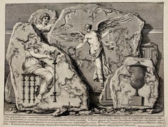
- (Large!) UNA DELLE QUATTRO FIGURE RAPPRESENTANTI QUATTRO VITTORIEBy Giovanni Battista PiranesiLocated in Santa Monica, CAGIOVANNI BATTISTA PIRANESI (1710-1778) UNA DELLE QUATTRO FIGURE RAPPRESENTANTI QUATTTRO VITTORIE, (Focillon 330, Wilton-Ely 463) 1750-1756 Etching, Plate 48 from “Le Antichita Romane“ vol. 3. Engraved by Jean Barbault...Category
1750s Old Masters More Prints
MaterialsEtching
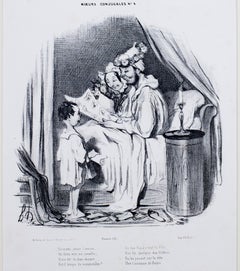
- "Ce Matin Avant l'Aurore, " Original Lithograph Genre Scene by Honore DaumierBy Honoré DaumierLocated in Milwaukee, WI"Ce Matin Avant l'Aurore" is an original lithograph by Honore Daumier, the second state of three. Original Text: Ce matin, avant l'aurore, Un Dieu vint me réveiller ; Il me dit : tu dors encore… Est-il temps de sommeiller ? De ton Papa c’est la fête, Fais lui quelque don flatteur En lui posant sur la tête Une Couronne de fleurs. Translation: This morning before dawn A God came to wake me up The curtains they were drawn And my snoring had to stop It is your daddy's birthday, A time for gifts and flowers To be placed on his head so gray Instead of his morning showers. Artwork Size: 9 1/4" x 9 1/4" Frame Size: 20 1/2" x 17 5/8" Artist Bio: Daumier was a prolific draftsman who produced over 4000 lithographs, he was perhaps best known for his caricatures of political figures and satires on the behavior of his countrymen, although posthumously the value of his painting has also been recognized. His works offer a commentary on social and political life in France in the 19th century. French caricaturist and painter, born at Marseilles. He showed in his earliest youth an irresistible inclination towards the artistic profession, which his father vainly tried to check by placing him first with a huissier, and subsequently with a bookseller. Having mastered the technique of lithography, Daumier started his artistic career by producing plates for music publishers, and illustrations for advertisements; these were followed by anonymous work for publishers, in which he followed the style of Charlet and displayed considerable enthusiasm for the Napoleonic legend. When, in the reign of Louis-Philippe, Philipon launched the comic journal, La Caricature, Daumier joined its staff, which included such powerful artists as Devéria, Raffet and Grandville, and started upon his pictorial campaign of scathing satire upon the foibles of the bourgeoisie, the corruption of the law and the incompetence of a blundering government. His caricature of the king as "Gargantua" led to Daumier's imprisonment for six months at Ste. Pélagie in 1832. The publication of La Caricature was discontinued soon after, but Philipon provided a new field for Daumier's activity when he founded the Charivari. For this journal Daumier produced his famous social caricatures, in which bourgeois society is held up to ridicule in the figure of Robert Macaire, the hero of a then popular melodrama. Another series, "L'Histoire Ancienne", was directed against the pseudoclassicism which held the art of the period in fetters. In 1848 Daumier embarked again on his political campaign, still in the service of Charivari, which he left in 1860 and rejoined in 1864. In spite of his prodigious activity in the field of caricature -- the list of Daumier's lithographed plates compiled in 1904 numbers no fewer than 3958 -- he found time for flight in the higher sphere of painting. Except for the searching truthfulness of his vision and the powerful directness of his brushwork, it would be difficult to recognize the creator of Robert Macaire, of Les Bas bleus, Les Bohémiens de Paris, and the Masques, in the paintings of "Christ and His Apostles" at the Ryks Museum in Amsterdam, or in his "Good Samaritan", "Don Quixote and Sancho Panza", "Christ Mocked...Category
1830s Old Masters Figurative Prints
MaterialsLithograph
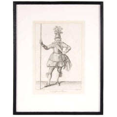
- Antique Copper Engraving of an Officer of Pikeman by Francis GroseBy Francis GroseLocated in New York, NYFrancis Grose entered the army early in life and served in the cavalry, infantry, and militia. He produced some compelling and sought after engravings on subjects including ancient a...Category
19th Century Old Masters Figurative Prints
MaterialsLithograph
- Johannes Sadeler I (Flemish 1550-1600) – Engraving 1582 - Jonah and the Whale IIBy Johannes Sadeler ILocated in Meinisberg, CHJohannes Sadeler I (Flemish, ∗ 1550 in Brussels, Belgium – † 1600 Venice, Italy) Jonah Spat Up by the Whale (Sheet II) Engraved by Sadeler after an image created by Theodor Bernard...Category
16th Century Renaissance Figurative Prints
MaterialsLaid Paper, Engraving

Recently Viewed
View AllMore Ways To Browse
Johannes Anders
German Old Masters
17th Century German
German Spot
West Window
Antique German Book
Old Antique Windows
School World Map
Johannes Engravings
17th Century German Engravings
Antique School Maps
Antique School Map
Old School Map Of The World
Large Map Of The Netherlands
Upper West Side
German School 17th Century
Blaeu World Map
Map Huge