Items Similar to Map of the County of Buckingham From an Actual Survey

Want more images or videos?
Request additional images or videos from the seller
1 of 5
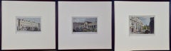
Christopher & John GreenwoodMap of the County of Buckingham From an Actual Survey1817-1832
1817-1832
About the Item
Cartographers Christopher (1786-1855) and John (1791-1867) Greenwood were surveyors from Yorkshire, who undertook an ambitious project to produce a series of large-scale maps of the counties of England, Wales and Scotland.The maps represent a remarkable and impressive surveying achievement forming an important record of the counties depicted.
In the years 1817-1832 the Greenwood brothers published the Atlas of The Counties of England from an Actual Survey. This Atlas was finely drafted and engraved and decorated with large vignettes of prominent buildings of the county. This map of Buckingham County is beautifully hand colored and is in very good condition. There is a vignette of Stowe House in the lower left corner.
- Creator:Christopher & John Greenwood (1786 - 1867)
- Creation Year:1817-1832
- Dimensions:Height: 25.25 in (64.14 cm)Width: 31 in (78.74 cm)
- Medium:
- Period:
- Condition:
- Gallery Location:Paonia, CO
- Reference Number:1stDibs: LU78033567391
About the Seller
4.9
Vetted Seller
These experienced sellers undergo a comprehensive evaluation by our team of in-house experts.
Established in 1978
1stDibs seller since 2017
103 sales on 1stDibs
Typical response time: 10 hours
- ShippingRetrieving quote...Ships From: Paonia, CO
- Return PolicyA return for this item may be initiated within 7 days of delivery.
More From This SellerView All
- AYX Map of Aix en Provence, France by J. Blaeu 17th c.By Joan (Johannes) BlaeuLocated in Paonia, CODetailed plan of Aix en Provence, in France. This print is a hand -colored double sheet engraving by the famous cartographer Joan (Johannes) Blaeu ( 1596 - 1673 ). The left side ...Category
Late 17th Century Other Art Style Landscape Prints
MaterialsEngraving
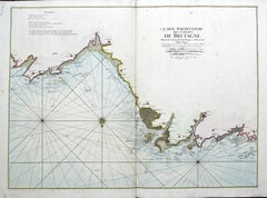
- Carte Particular Des Costes De Bretagne Depuis le Cap de Frehel, Jusques a PerrosBy Pierre MortierLocated in Paonia, COCarte Particulaire Des Costes De Bretagne Depuis Le Cap de Frehel, Jusques a Perros, & L’Isle Tome. This large sea scale chart shows part of the northwestern co...Category
1690s Landscape Prints
MaterialsEngraving
- England Map of the County of Southampton from an Actual SurveyLocated in Paonia, COCartographers Christopher (1786-1855) and John (1791-1867) Greenwood were surveyors from Yorkshire, who undertook an ambitious project to produce a series of large-scale maps of the counties of England, Wales and Scotland.The maps represent a remarkable and impressive surveying achievement forming an important record of the counties depicted. In the years 1817-1832 the Greenwood brothers published the Atlas of The Counties of England from an Actual Survey. This Atlas was finely drafted and engraved and decorated with large vignettes of prominent buildings of the county. This map of Southampton County is beautifully hand colored and is in very good condition. There is a vignette of Winchester Cathedral...Category
19th Century Other Art Style Landscape Prints
MaterialsEngraving
- Three Varieties of Leucoium , Hortus Eystettensis, ( after ) BeslerBy (After) Basilius BeslerLocated in Paonia, COThree Varieties of Leucoium (I. Leucoium purpureum variegatum flore pleno. II Leucoium pleno flor album purpureis maculis signatum. III. Leucoium pleno flor album sanguine maculis signatum), from B. Besler, Hortus Eystettensis possibly (after) Basil Besler...Category
Early 17th Century Landscape Prints
MaterialsEngraving
- Carte Particuliere Des Coste De Bretagne qui Comprend MorlaixBy Pierre MortierLocated in Paonia, COCarte Particuliere Des Costes De Bretagne qui Comprend Morlaix, Saint Paul de Leon, les Sept Isles, et L’Isle. Faite par ordre Exprez Du Roy de France is from the collection of ch...Category
1690s Landscape Prints
MaterialsEngraving
- Persiae, Armeniae, Natoliae et Arabiae Descriptio per Frederick deWit 1666 mapLocated in Paonia, COMap of Persiae, Armeniae, Natoliae et Arabiae Descriptio per F de Wit 1688 engraving from: Atlas Contractus Orbis Terrarum Praecipuas ac Novissimas Complectens Tabulas. Amsterdam, N. Visscher, 1656-77. (Koeman III, Vis5-8) This highly decorative map of the Middle East is by the Dutch engraver, publisher, and map seller...Category
1660s Realist Landscape Prints
MaterialsEngraving


You May Also Like
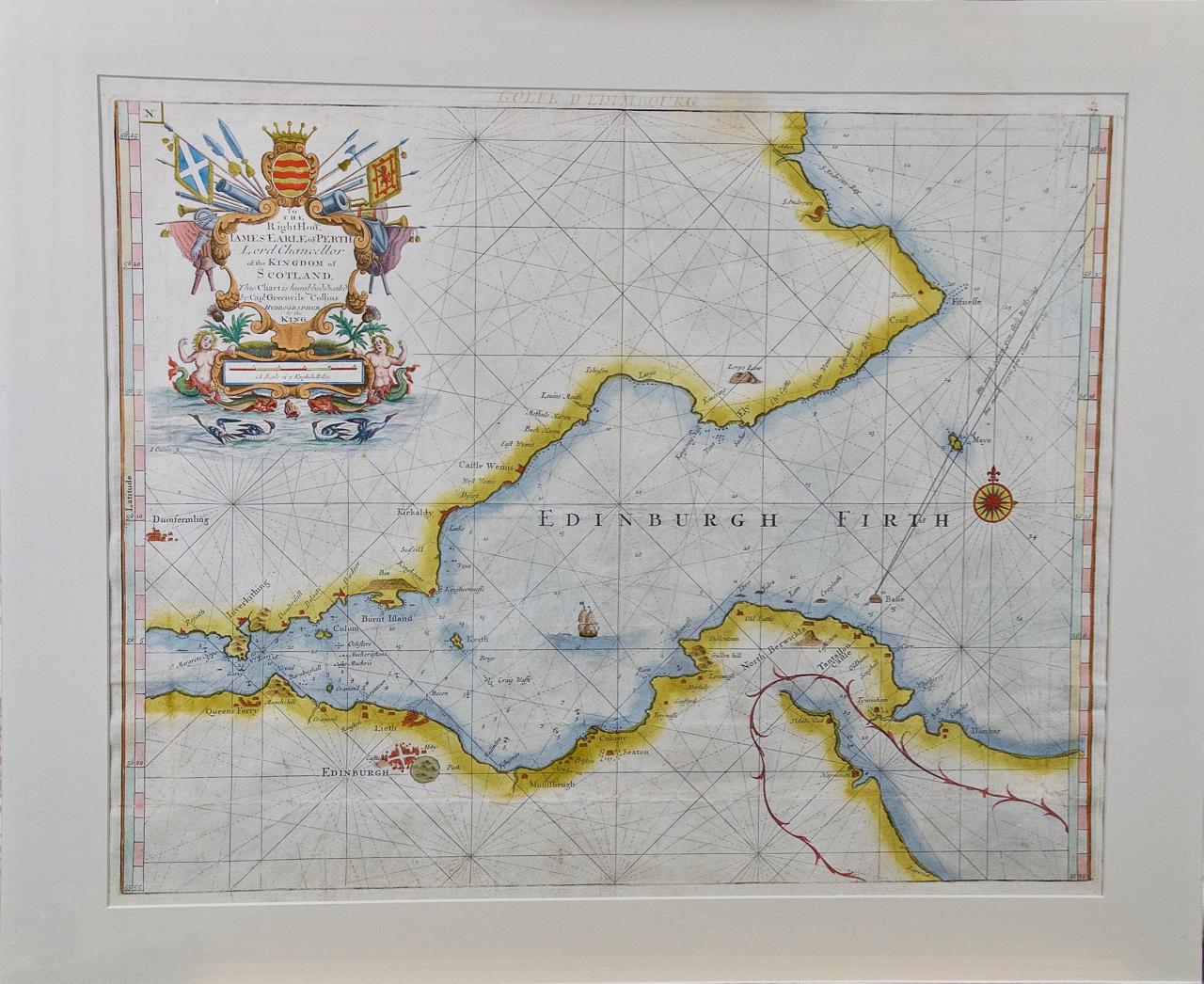
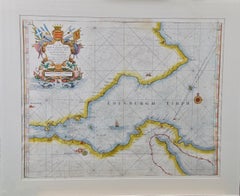
- Edinburgh, Scotland: An Original 17th C. Hand-Colored Engraved Sea ChartBy Captain Greenvile CollinsLocated in Alamo, CAThis hand-colored sea chart is entitled "Edinburgh Firth" from "Great Britain's Coasting Pilot. Being a New and Exact Survey of the Sea-Coast of England" by Captain Greenville Collin...Category
Late 17th Century Landscape Prints
MaterialsEngraving
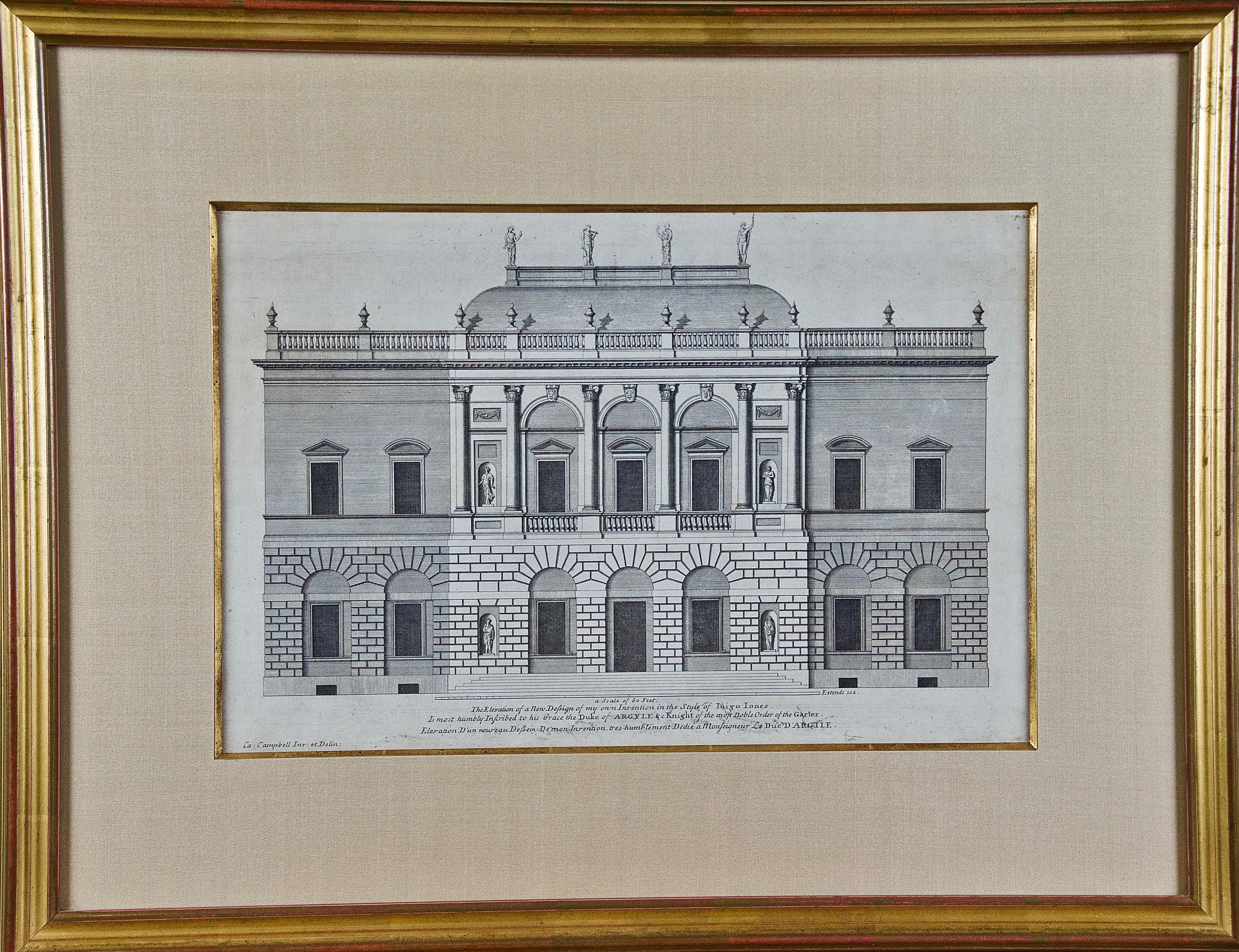
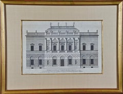
- 18th C. Architectural Engraving from "Vitruvius Britannicus" by Colen CampbellBy Colen CampbellLocated in Alamo, CA"The Elevation of a New Design of my Own Invention in the Style of Inigo Jones, Is most humbly Inscribed to his Grace the Duke of Argyle & Knight of the most Noble Order of the Garter", plate 20 from Colen Campbell's first edition of "Vitruvius Britannicus...Category
1710s Other Art Style Landscape Prints
MaterialsEngraving
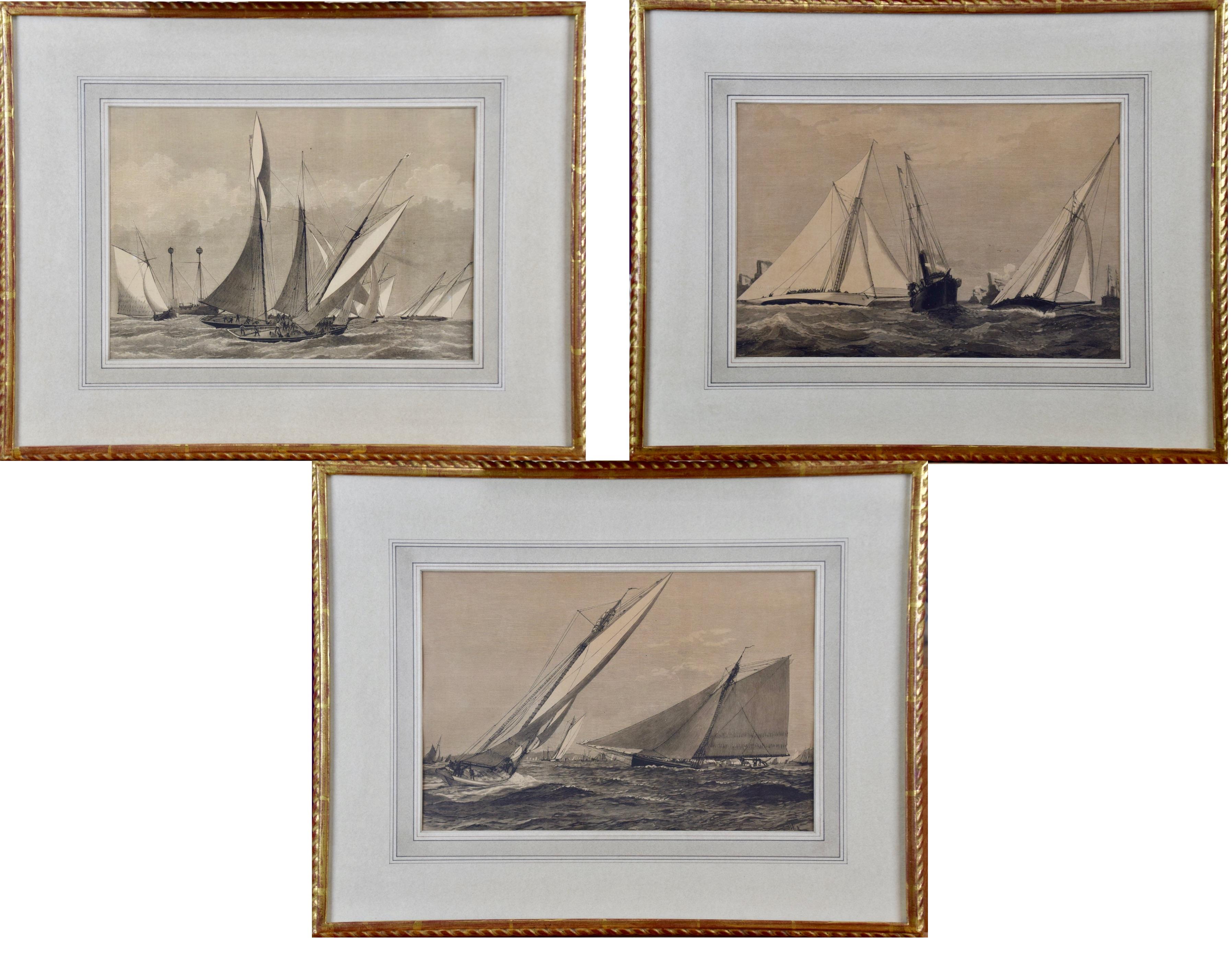
- 1885 America's Cup Sailing Yachts: Set of 3 Original 19th C. EngravingsLocated in Alamo, CAThis is a set of three woodcut engravings produced in 1885 to commemorate the sailing yacht trials competition to determine the team to represent the United States in the America's Cup races off the New Jersey coast in that same year. These three beautiful woodcut engravings are part of a group of six equally attractive prints, all framed identically in gold scrolled frames with pleasing light grey French mats each with a medium grey band. Each frame measures 16.13" x 17.25" x 0.5". See Item Reference #LU117325094852 to view the other three images. These may be purchased individually for $1,075/each, as a set of three for $2,875/3 or as a set of six for $5,575/6. Any number of these engravings would make for a striking display grouping. Three American racing yachts, the Puritan, the Priscilla and the Bedouin, participating in the 1885 America’s Cup trials off the coast of New Jersey are shown in their qualifying races. The Puritan, owned by several members of the Eastern Yacht Club...Category
1880s Landscape Prints
MaterialsEngraving
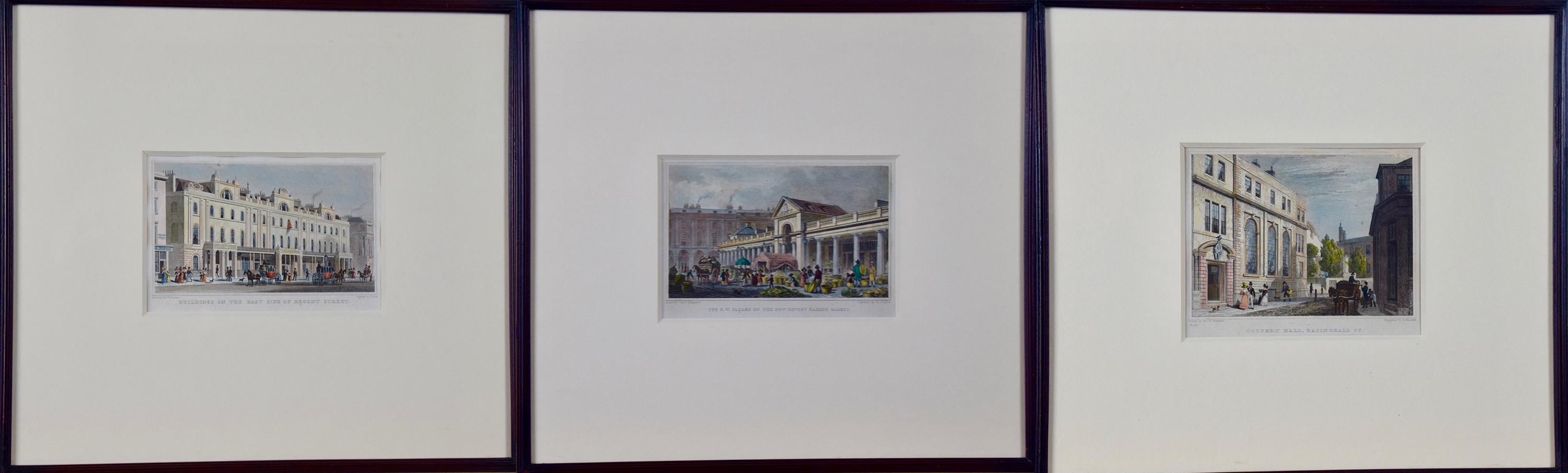
- Three 19th C. Hand Colored Engravings of London Architecture by T. ShepherdBy Thomas Hosmer ShepherdLocated in Alamo, CAA set of three hand-colored engravings from "Metropolitan Improvements; or London in the Nineteenth Century", published in London, England in 1828. The scenes were drawn by Thomas Ho...Category
1820s Realist Landscape Prints
MaterialsEngraving
- Canterbury: An Original 16th C. Framed Hand-colored Map by Braun & HogenbergBy Franz HogenbergLocated in Alamo, CAThis is a framed 16th century map and city view of Canterbury, England entitled "Cantuarbury" by Braun & Hogenburg, from their famous landmark atlas of city views 'Civitates Orbis Terrarum' (Atlas of the Cities of the World), which was first published in Cologne, Germany in 1572. The map of Canterbury was first published in 1588. It depicts a detailed birdseye view of the completely walled and fortified city of Canterbury, with its cathedral the most prominent feature. The coat of arms of England, Canterbury, and the Archbishop of Canterbury are included. This beautifully hand-colored map is presented in a gold-colored wood frame with a beaded inner trim and a paprika-colored mat that highlights details in the map. The frame measures 18.75" high by 22.25" wide by 0.875" deep. There is a central vertical fold, as issued. The map is in excellent condition. Braun and Hogenberg's 'The Civitates Orbis Terrarum' was the second atlas of maps ever published and the first atlas of cities and towns of the world. It is one of the most important books published in the 16th century. Most of the maps in the atlas were engraved by Franz Hogenberg and the text, with its descriptions of the history and additional factual information of the cities, was written by a team of writers and edited by Georg Braun. The work contained 546 bird-eye views and map views of cities and towns from all over the world. It gave graphic representation of the main features of the illustrated cities and towns, including the buildings and streets. Although the ordinary buildings are stylized, the principal buildings are reproduced from actual drawings created on location. The principal landmarks and streets can still be recognized today. In addition, the maps often include the heraldic arms of the city, the nature of the surrounding countryside, the important rivers, streams and harbors, even depicting stone bridges, wooden pontoons, flat-bottomed ferries, ships and working boats, wharves and jetties, as well as land-based activities, including horsemen, pedestrians, wagons, coaches, and palanquins. Small vignettes are often included which illustrate the trade, occupations and habits of the local inhabitants, such as agriculture, paper-making and textiles, as well as local forms of punishment, such as gibbets, wheels, floggings etc. Large figures dressed in their local costume are often presented out of proportion in the foreground. The aim of the authors was to give as much information as possible in a pleasing visual form. They succeeded in creating maps that were both informative and decorative works of art. The atlas is a wonderful glimpse of life in medieval Europe. Georg Braun (1541-1622) was German Catholic...Category
16th Century Old Masters Landscape Prints
MaterialsEngraving
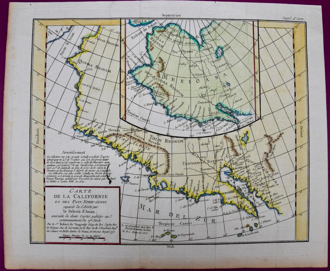
- California: 18th Century Hand-colored Map by de VaugondyBy Didier Robert de VaugondyLocated in Alamo, CAThis is an 18th century hand-colored map of the western portions of North America entitled "Carte de la Californie et des Pays Nord-Ouest separés de l'Asie par le détroit d'Anian, ex...Category
1770s Landscape Prints
MaterialsEngraving


Recently Viewed
View AllMore Ways To Browse
Antique Survey
Large Scale Map
Survey Map
Series Hand Colored Engravings
Antique Surveyor
Antique Surveyors
Maps Wales
Map Of Wales
Antique Style Atlas
Antique Maps Wales
Antique Map Wales
Antique Map Of Wales
Antique Maps Of Wales
Map 1786
Antique Map Yorkshire
Antique Maps Yorkshire
Antique Map Of Yorkshire
Marilyn Crying