Items Similar to Four Framed Hogarth Engravings "Four Times of the Day"


Want more images or videos?
Request additional images or videos from the seller
1 of 24
William Hogarth Four Framed Hogarth Engravings "Four Times of the Day"1738, 1822
1738, 1822
About the Item
The four plates in this "Four Times of the Day" set were created utilizing both engraving and etching techniques by William Hogarth in 1738. Hogarth's original copper plates were refurbished where needed by James Heath and these engravings were republished in London in 1822 by Braddock, Cradock & Joy. This was the last time Hogarth's original copper plates were used for printing. Most were melted down during World War I for the construction of bombs. Printed upon early nineteenth century wove paper and with large, full margins as published by William Heath in 1822. The inscription below each print reads "Invented Painted & Engraved by Wm. Hogarth & Publish'd March 25. 1738 according to Act of Parliament".
These large folio sized "Four Times of the Day" engravings/etchings are presented in complex gold-colored wood frames with black bands and scalloped gold inner trim. A majority of each thick impressive frame is covered with glass applied near the outer edge. Each frame measures 25.75" high, 22.25" wide and 1.88" deep. There are a few small dents in the edge of these frames, which are otherwise in very good condition. "Morning" has two focal areas of discoloration in the upper margin and some discoloration in the right margin, a short tear in the left margin and a short tear or crease in the right margin. "Noon" has a spot in the upper margin that extends into the upper image, but it is otherwise in very good condition. "Evening" has a faint spot in the upper margin, but it is otherwise in very good condition. "Night" is in excellent condition.
The "Four Times of the Day" series is in the collection of many major museums, including: The British Museum, The Metropolitan Museum of Art, The Tate Museum, The Chicago Art Institute and The Victoria and Albert Museum.
Through this series Hogarth is portraying early 18th century London street life at "Four Times of the Day". His characters are exhibiting their personalities, quircks, strange activities, but he also wants to draw attention the disparities between the wealthy aristocracy and the common working class.
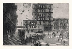
Plate 1, "Morning" depicts morning in Covent Garden in the winter in front of Tom King's Coffee House, where a fight has broken out in the doorway and someone's wig flies through the air. Vegetable and fruit vendors are setting up their display for the morning market, while two aristocratic men are fondling and kissing young market girls behind them. They are observed by a well-dressed elderly woman, who is heading to St. Paul's for church services. Her obviously very cold page boy follows her carrying her prayer book. The woman is ignoring a woman begging for a donation. In the upper right a clock above St. Paul's shows that is almost 7:00 AM. A small statue above the clock depicts Father Time with a scythe and an hourglass. Below the clock are the words "Sic Transit Gloria Mundi" (Thus passes the Glory of the World). In the lower left two children watch a woman carry a loaded basket of vegetables on her head on her way to sell them in the market.
Plate 2, "Noon" is thought to represent the dichotomy between the lives of the 18th century English working classes and that of the aristocracy. People exiting a French Huguenot church in the Soho region on the right are the wealthy and aristocracy, as well as the clergy. An aristocratic man, woman and child are showing off their elevated status with their dress and carriage. The man and even the child are carrying fashionable canes and a child seen from the rear is wearing extremely expensive clothing and a head covering resembling a beehive. The working class are seen on the left in the street in front of a restaurant with a sign "Good Eating" and a tavern called "Good Woman". A woman leaning out of a window on the second floor is arguing with a man over a plate of food and has spilled her food into the street below. A footman is fondling a servant girl from behind. She is carrying a tray, which may have contained a plate which has fallen off onto a young boy's head. He is rubbing his head and crying because his plate carrying a pie has broken and the pie has fallen to the street, where a young street urchin girl is eating it the remnants. No one pays attention to a dead cat which lies in the middle of the street. Life on both sides of the street seems to have its problems. The clock on the tower of St. Giles-in-the-Fields in the background reads 11:30 or 11:45, almost Noon.
Plate 3, "Evening" depicts Islington is the northern edge of London, a popular amusement center for London's middle class. Unlike the crowded London city streets, here we see expansive sky and rolling hills in the background with an evening sunset, probably in summer. Sadlers Wells Theater on the left was belittled at the time for attracting tradesmen and domineering snobbish wives. In the foreground is a large, possibly pregnant woman who is walking next to her husband who looks unhappy, meek, presumably brow-beaten. A cow is being milked behind them. The horns of the animal are projected over the man's head, presumably symbolizing his lowly family stature. Even the dog walking in front, hanging his head and appearing downtrodden. On the left a girl scolds a boy who is crying, presumably mimicking their parent's relationship. A pub is seen on the right with people enjoying the evening and in an outdoor seating area.
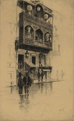
Plate 4, "Night" depicts a side street in Charing Cross. Night deals with the miseries of London life. Two pubs are seen on this small street, the Earl of Cardigan on the left and the Rummer Tavern on the right. These were both Freemason Lodges in the 1730's when the print was composed by Hogarth. To the left, a drunken barber-dentist has just cut his customer. Bowls of blood from earlier patients lie on a ledge outside the window. Homeless people are huddled together for warmth under the ledge. In the foreground a drunken man and a woman stumble down the street. Blood on their heads suggests a recent bar fight. The contents of a chamber pot fall on them from a window above them. He is thought to represent Sir Thomas de Veil, a magistrate who was well known at the time for the severity of his sentencing, in particular for gin-sellers. Ironically, he is too drunk to notice the chaos around him. On the right the 'Salisbury Flying Coach' has overturned next to a bonfire. People are trying to get out, while someone inside has fired their gun. Everything on the street seems in chaos, with the exception of man, possibly a tavern or inn keeper, who is calmly smoking a pipe while he pours the contents of a barrel into a larger barrel. The equestrian statue of Charles I by Le Sueur is seen in the background at the end of the street.
Artist: William Hogarth (1697-1764) was an English painter, printmaker, pictorial satirist, social critic, and editorial cartoonist. Hogarth's work was extremely diverse, ranging from serious realistic paintings and portraits to satire and moralistic pieces filled with symbolism. He often communicated his moral message in a series of paintings and engravings, such as: A Rake's Progress, Marriage A-la-Mode and A Harlot's Progress. He was by far the most significant English artist of his generation and inspired a movement of English caricaturists and satirists, including James Gillray (1756-1815), Thomas Rowlandson (1757-1827), Isaac Cruickshank (1764-1811) and George Cruickshank (1792-1878). His work has been studied intensely for the greater than two and a half centuries since his death with several academic scholars focusing their careers on the analysis of every element of each of his creations.
- Creator:William Hogarth (1697 - 1764, British)
- Creation Year:1738, 1822
- Dimensions:Height: 25.75 in (65.41 cm)Width: 22.25 in (56.52 cm)Depth: 1.88 in (4.78 cm)
- Medium:
- Movement & Style:
- Period:
- Condition:
- Gallery Location:Alamo, CA
- Reference Number:
About the Seller
5.0
Platinum Seller
These expertly vetted sellers are 1stDibs' most experienced sellers and are rated highest by our customers.
Established in 2011
1stDibs seller since 2019
233 sales on 1stDibs
Typical response time: 1 hour
- ShippingRetrieving quote...Ships From: Alamo, CA
- Return PolicyA return for this item may be initiated within 7 days of delivery.
More From This SellerView All
- Canterbury: An Original 16th C. Framed Hand-colored Map by Braun & HogenbergBy Franz HogenbergLocated in Alamo, CAThis is a framed 16th century map and city view of Canterbury, England entitled "Cantuarbury" by Braun & Hogenburg, from their famous landmark atlas of city views 'Civitates Orbis Terrarum' (Atlas of the Cities of the World), which was first published in Cologne, Germany in 1572. The map of Canterbury was first published in 1588. It depicts a detailed birdseye view of the completely walled and fortified city of Canterbury, with its cathedral the most prominent feature. The coat of arms of England, Canterbury, and the Archbishop of Canterbury are included. This beautifully hand-colored map is presented in a gold-colored wood frame with a beaded inner trim and a paprika-colored mat that highlights details in the map. The frame measures 18.75" high by 22.25" wide by 0.875" deep. There is a central vertical fold, as issued. The map is in excellent condition. Braun and Hogenberg's 'The Civitates Orbis Terrarum' was the second atlas of maps ever published and the first atlas of cities and towns of the world. It is one of the most important books published in the 16th century. Most of the maps in the atlas were engraved by Franz Hogenberg and the text, with its descriptions of the history and additional factual information of the cities, was written by a team of writers and edited by Georg Braun. The work contained 546 bird-eye views and map views of cities and towns from all over the world. It gave graphic representation of the main features of the illustrated cities and towns, including the buildings and streets. Although the ordinary buildings are stylized, the principal buildings are reproduced from actual drawings created on location. The principal landmarks and streets can still be recognized today. In addition, the maps often include the heraldic arms of the city, the nature of the surrounding countryside, the important rivers, streams and harbors, even depicting stone bridges, wooden pontoons, flat-bottomed ferries, ships and working boats, wharves and jetties, as well as land-based activities, including horsemen, pedestrians, wagons, coaches, and palanquins. Small vignettes are often included which illustrate the trade, occupations and habits of the local inhabitants, such as agriculture, paper-making and textiles, as well as local forms of punishment, such as gibbets, wheels, floggings etc. Large figures dressed in their local costume are often presented out of proportion in the foreground. The aim of the authors was to give as much information as possible in a pleasing visual form. They succeeded in creating maps that were both informative and decorative works of art. The atlas is a wonderful glimpse of life in medieval Europe. Georg Braun (1541-1622) was German Catholic...Category
16th Century Old Masters Landscape Prints
MaterialsEngraving
- Meissen, Germany : A Large Framed 18th Century Map by Petrus SchenkLocated in Alamo, CAThis is a hand-colored 18th century map of the Meissen region of Germany, entitled "Geographischer Entwurff Derer Aemmter Meissen als Creys-Procuratur-Schul-und Stiffts-Ammt benebst ...Category
Mid-18th Century Old Masters Landscape Prints
MaterialsEngraving
- Northern Italy: A 16th Century Hand-colored Map by Abraham OrteliusBy Abraham OrteliusLocated in Alamo, CAThis is a framed 16th century hand-colored copperplate map of northern Italy entitled "Veronae Urbis Territorium a Bernardo Bragnolo Descriptium" by Abraham Ortelius from his atlas "Theatrum Orbis Terrarum", which was the first modern atlas of the world, with the first volume published in 1570. This map was part of a subsequent volume, published in Antwerp in 1584. It was based on an earlier map by Bernardo Brognoli. This beautiful map of northern Italy is focussed on Verona and its environs, including Mantua. Lake Garda and the South Tyrol mountains are prominently depicted. There is a very large striking cartouche in the upper left and a decorative distance scale in the lower right. This striking hand-colored map of northern Italy is presented in a gold-colored wood frame and an olive green-colored mat. It is glazed with UV conservation glass. All mounting materials used are archival. The frame measures 21.5" high by 28" wide by 0.75" deep. There is a central vertical fold, as issued, with slight separation of the lower portion of the fold. There are faint spots in the upper and right margins, but the map is otherwise in very good condition. Abraham Ortelius (also known as Ortels, Orthellius, and Wortels) (1527-1598) was a Dutch cartographer, geographer, and cosmographer. He began his career as a map colorist. In 1547 he entered the Antwerp guild of St Luke as an "illuminator of maps". He had an affinity for business from an early age and most of his journeys before 1560, were for business. He was a dealer in antiques, coins, maps, and books. His business income allowed him to acquire an extensive collection of medals, coins, and antiques, as well as a large library of books...Category
16th Century Old Masters Landscape Prints
MaterialsEngraving
- Frankfort, Germany: A 16th Century Hand-colored Map by Braun & HogenbergBy Franz HogenbergLocated in Alamo, CAThis is a 16th century original hand-colored copperplate engraved map of Frankfort, Germany entitled "Francenbergum, vel ut alij Francoburgum Hassiae Opp" by Georg Braun & Franz Hogenberg, from their famous city atlas "Civitates Orbis Terrarum", published in Cologne, Germany in 1595. This is an English translation of an excerpt from the original text in the atlas: "Frankenberg or, according to others, Francoburgum, a town in Hesse. Charlemagne vested the town of Frankenberg with many freedoms and privileges, which it still enjoys to this day, and on account of its valiant and victorious soldiers awarded a signet, upon which there formerly appeared a golden castle with a tower, together with the letter F and a golden crown. Frankenberg, seen here from the northeast, lies on a hill above the River Eder. The hillside is covered with fields neatly separated by bushes and fences. Soaring above the town is the massive Liebfrauenkirche, which was modelled on St Elizabeth's church in Marburg. The New Town was founded in 1335 at the foot of the hill (right) and merged with the Old Town as late as 1556. Frankenberg was founded by Conrad of Thuringia in 1233/34 to prevent the archbishops of Mainz from expanding their sphere of influence...Category
16th Century Old Masters Landscape Prints
MaterialsEngraving
- Persia, Armenia & Adjacent Regions: A Hand-colored 17th Century Map by De WitBy Frederick de WitLocated in Alamo, CAThis colorful and detailed 17th century copperplate map by Frederick De Wit was published in Amsterdam between 1666 and 1690. It depicts the Caspian Se...Category
Late 17th Century Old Masters More Prints
MaterialsEngraving
- Map of the Russian Empire: An Original 18th Century Hand-colored Map by E. BowenLocated in Alamo, CAThis is an original 18th century hand-colored map entitled "A New & Accurate Map of The Whole Russian Empire, As Contain'd Both In Europe and Asia, Drawn from Authentic Journals, Sur...Category
Mid-18th Century Old Masters Landscape Prints
MaterialsEngraving


You May Also Like
- Hidden Cities I / second stateBy Peter MiltonLocated in New York, NY“Hidden Cities I : The Ministry. Second State.” Contemporary artist Peter Milton created this etching and engraving in 2006. The printed image size is Image size 23.50 x 36.88 inches and the paper size is 31 x 42 inches. This impression is signed, dated, and titled in pencil and inscribed “11/75” – the 11th impression from the total printing of 75. “I do love to draw. I feel that I am being granted membership in the Brotherhood of Merlin, conjuring forth some apparition. As a drawing develops, I sense a vague presence coming more and more into focus, something in a white fog emerging and becoming increasingly palpable.” – P. Milton, “The primacy of touch. The Drawings of Peter Milton” “Working in layers, Milton begins with drawings based on people and places, with nods to Western art history and culture. He is a master of the appropriated image, a term that may conjure Andy Warhol and his Pop Art comrades. But Milton steps further back in history, avoiding the Pop sense of cool advertising and popular culture references. Instead, a broader cultural past is tapped through historical photographs of key players, architecture, and locales, which he reinvents by hand. He adds content drawn from his life as an avid reader – always with multiple possible interpretations – thus incorporating deeper meaning in his cinematic worlds. Elements of Greek mythology, classical music, art history, and history coalesce in his images, which embrace the messiness, sorrow, and elation that is life. One is hard-pressed to imagine a more erudite, skilled, passionate, and cheeky soul. In addition to a storied career in printmaking, since 2007 Milton has fearlessly produced artwork digitally. He now creates images using Adobe Photoshop in files consisting of more than two thousand layers, which are printed both as digital prints on paper and, for display on Led light boxes...Category
21st Century and Contemporary American Realist Landscape Prints
MaterialsEngraving, Etching
- Restaurant in Mott StreetBy Charles Frederick William MielatzLocated in New Orleans, LAThe image depicts a restaurant on New York's Mott Street with ornamental iron work on the balconies. There are six figures in the scene in various stages of contrast. Mott Street is considered the unofficial Main Street of New York's Chinatown. Ella Fitzgerald sang it best: “And tell me what street compares with Mott Street in July? Sweet pushcarts gently gliding by.” CFW Mielatz was an early influence on the drypoints and etchings of Martin Lewis. This piece was created in 1906 and it is signed in pencil. It is part of the collection of New York's Metropolitan Museum of Art C.F.W. Mielatz American, 1860-1919 Born in Bredding, Germany in 1864, Mielatz emigrated to the United States as a young boy and studied at the Chicago School of Design. Mostly self-taught, his first prints were large New England landscapes reminiscent of the painter-etcher school of American Art. Around 1890 he started to produce prints of New York City and by the time of his death, the number totaled over ninety images. He was a master technician in the field of etching, reworking many of his plates to get the exact feeling he was seeking. Mielatz was a member of the New York Etching...Category
Early 20th Century American Modern Landscape Prints
MaterialsEtching, Drypoint
- Mont et Mervale (Mountains and Wonder)By Christine RavauxLocated in New Orleans, LABorn in Charleroi, Belgium, Christine Ravaux is an artist who mirrors her surroundings in the mezzotints she creates. She has portrayed the black hills that dot the landscape of the ...Category
1990s Contemporary Landscape Prints
MaterialsMezzotint, Aquatint
- Lafitte's Blacksmith House (a bar named for a pirate on Bourbon St, New Orleans)By Frederick MershimerLocated in New Orleans, LALafitte's Blacksmith Shop is a New Orleans landmark at 941 Bourbon St. Like most New Orleans legends, history of Lafitte's Blacksmith Shop is a gumbo of tru...Category
Early 2000s Contemporary Landscape Prints
MaterialsMezzotint, Aquatint
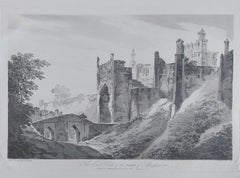
- India William Hodges 'The East End of the Fort of Mongheer' India EngravingBy William HodgesLocated in Norfolk, GBAquatint with soft ground etching from the seminal publication, Selected Views in India, drawn on the Spot, in the Years 1780, 1781, 1782 and 1783, and Executed in Aquatint in 1786 -...Category
Late 18th Century Other Art Style Landscape Prints
MaterialsEngraving
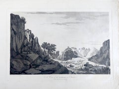
- India William Hodges 'A View of the Ravines at Etana' Early India EngravingBy William HodgesLocated in Norfolk, GBWilliam Hodges Plate 27 'A View of the Ravines at Etawa' Published 20th May 1787 by J Wells, 22 Charing Cross. Page size, 16.5” x 22.5”, image 11.25 x 18” Aquatint with soft gro...Category
Early 2000s Other Art Style Landscape Prints
MaterialsEngraving