Items Similar to 19th Century John Cary Map of North Part of West Riding of Yorkshire, C.1805


Want more images or videos?
Request additional images or videos from the seller
1 of 13
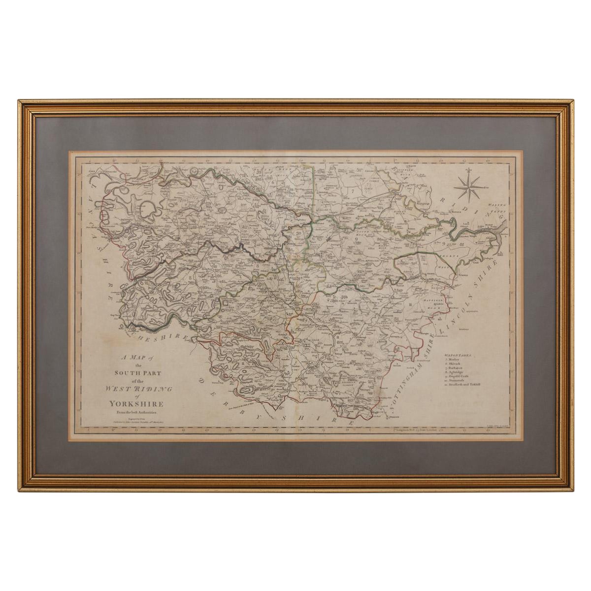
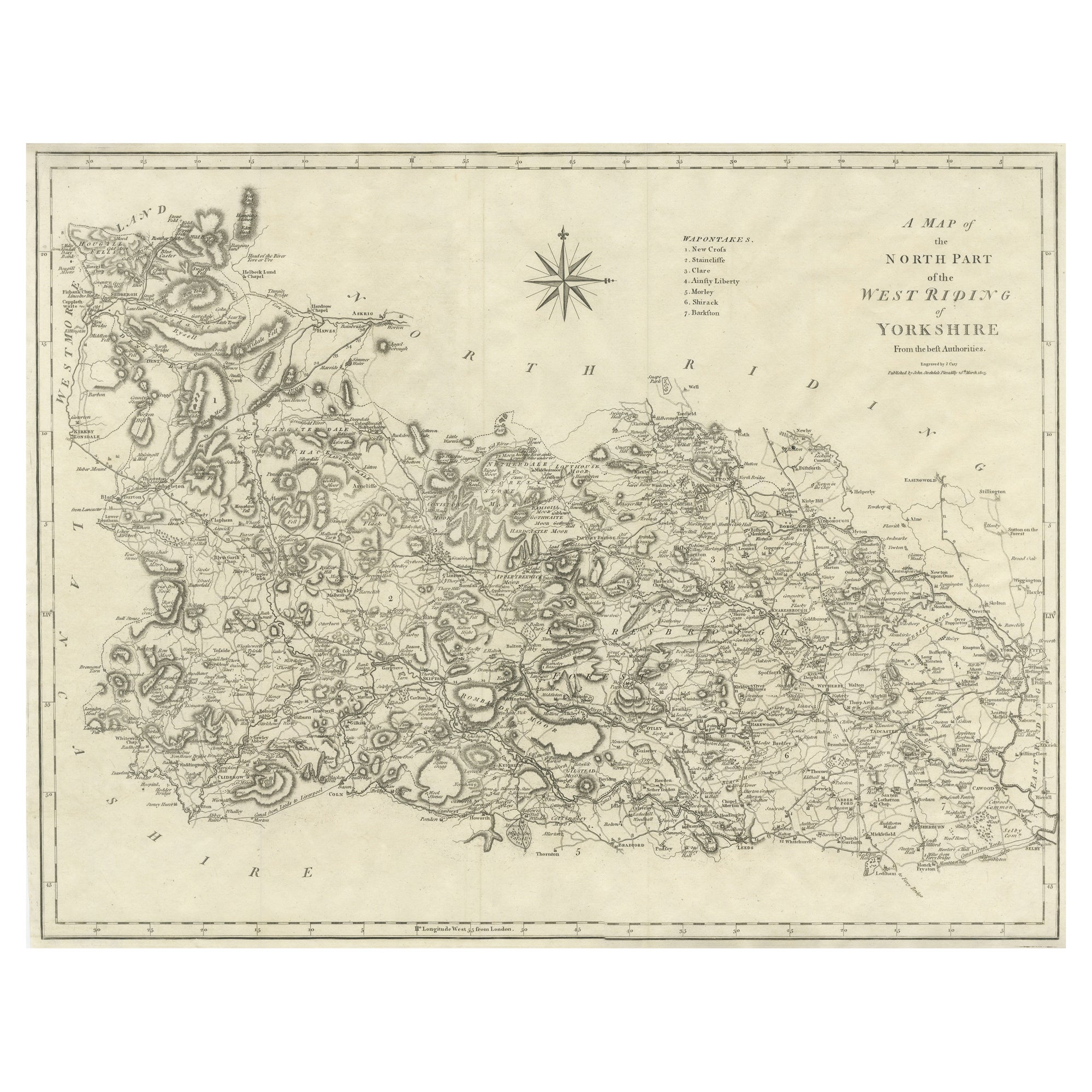
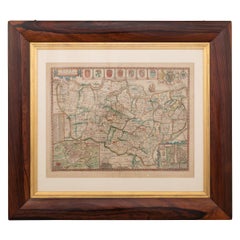
19th Century John Cary Map of North Part of West Riding of Yorkshire, C.1805
About the Item
Antique 19th century British original John Cary sr (1755-1835) map of North part of the West Riding of Yorkshire, From the beft Authorities. Engraved J Cary, published by John Stockdale, Piccadilly, 26th March 1805, mounted in solid wood frame with glazed front. John Cary sr. was described by his biographer, George Fordham as “The most prominent and successful exponent of his time… the founder of what we may call the modern English school [of mapmaking]”
Condition:
In good condition, wear as expected with age and comes newly framed.
Size:
Height 54cm
Width 66.5cm.
- Creator:John Cary (Maker)
- Dimensions:Height: 21.26 in (54 cm)Width: 26.19 in (66.5 cm)Depth: 0.79 in (2 cm)
- Materials and Techniques:
- Place of Origin:
- Period:
- Date of Manufacture:circa 1805
- Condition:Wear consistent with age and use. Minor fading. In Good Condition - Wear as expected with age and comes newly framed.
- Seller Location:Royal Tunbridge Wells, GB
- Reference Number:
About the Seller
5.0
Platinum Seller
These expertly vetted sellers are 1stDibs' most experienced sellers and are rated highest by our customers.
Established in 2014
1stDibs seller since 2015
367 sales on 1stDibs
Typical response time: <1 hour
- ShippingRetrieving quote...Ships From: Royal Tunbridge Wells, United Kingdom
- Return PolicyA return for this item may be initiated within 14 days of delivery.
More From This SellerView All
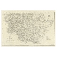
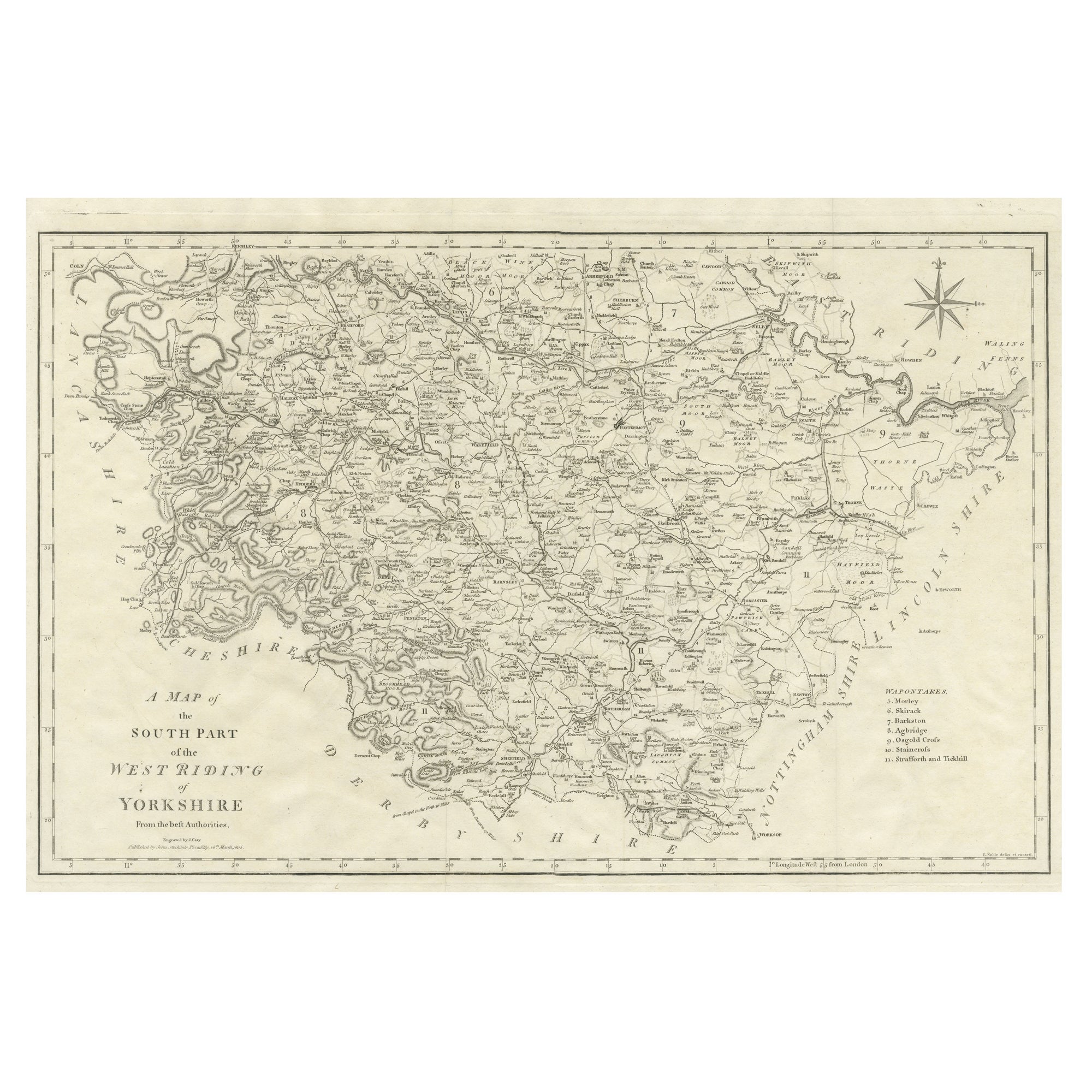
- 19th Century John Cary Map of South Part of West Riding of Yorkshire, circa 1805By John CaryLocated in Royal Tunbridge Wells, KentAntique 19th century British original John Cary sr (1755-1835) map of South part of the West Riding of Yorkshire, From the beft Authorities. Engraved J Car...Category
Antique 19th Century British Maps
MaterialsPaper
- 17th Century John Speed Map of Denbighshire, c.1610By John SpeedLocated in Royal Tunbridge Wells, KentAntique early 17th century British very rare and original John Speed, hand coloured map of Denbighshire, dated 1610, by John Sunbury and George Humble. John...Category
Antique 17th Century British Maps
MaterialsWood, Paper
- 17th Century John Speed Map of the Barkshire Described, c.1616By John SpeedLocated in Royal Tunbridge Wells, KentAntique 17th century British very rare and original John Speed (1551-1629) map of the Barkshire Described, J. Sud and Georg Humble, publication (1616 or lat...Category
Antique 17th Century British Maps
MaterialsPaper
- 17th Century John Speed Map of Kent with Her Cities & Earles Described, C.1676By John SpeedLocated in Royal Tunbridge Wells, KentAntique 17th century British very rare and original John Speed (1551-1629) map of Kent with her Cities and Earles described and observed, Thomas Bassett & ...Category
Antique 17th Century British Maps
MaterialsPaper
- 18th Century Emanuel Bowen Map of County of York, c.1740By Emanuel BowenLocated in Royal Tunbridge Wells, KentAntique 18th century British rare and original Emanuel Bowen (1694-1767) map of the County of York divided into its Ridings and subdivided into wapontakes, mounted in solid wood fram...Category
Antique Early 18th Century British Maps
MaterialsPaper
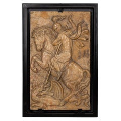
- 19th Century Italian Marble Plaque of George Slaying the Dragon, C.1870Located in Royal Tunbridge Wells, KentAntique 19th Century Italian Grand Tour marble relief depicting St George slaying the Dragon. England has always been one of the leading countries in terms of travelling and explori...Category
Antique 19th Century Italian Grand Tour Historical Memorabilia
MaterialsMarble


You May Also Like
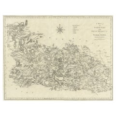
- Large Antique County Map of the West Riding of Yorkshire 'North Part', EnglandLocated in Langweer, NLAntique map titled 'A Map of the North Part of the West Riding of Yorkshire from the best Authorities'. Original old county map of the north part of the West Riding of Yorkshire, Eng...Category
Antique Early 19th Century Maps
MaterialsPaper
- Large Antique County Map of the West Riding of Yorkshire 'South Part', EnglandLocated in Langweer, NLAntique map titled 'A Map of the South Part of the West Riding of Yorkshire from the best Authorities'. Original old county map of the south part of the West Riding of Yorkshire, Eng...Category
Antique Early 19th Century Maps
MaterialsPaper
- Antique Map of Bavaria and Salzburg by Cary, 1811By John CaryLocated in Langweer, NLAntique map titled 'A New Map of the Circle of Bavaria'. Antique map of Bavaria and Salzburg, Germany. Covers the Duchy of Bavaria and the mountainous A...Category
Antique Early 19th Century Maps
MaterialsPaper
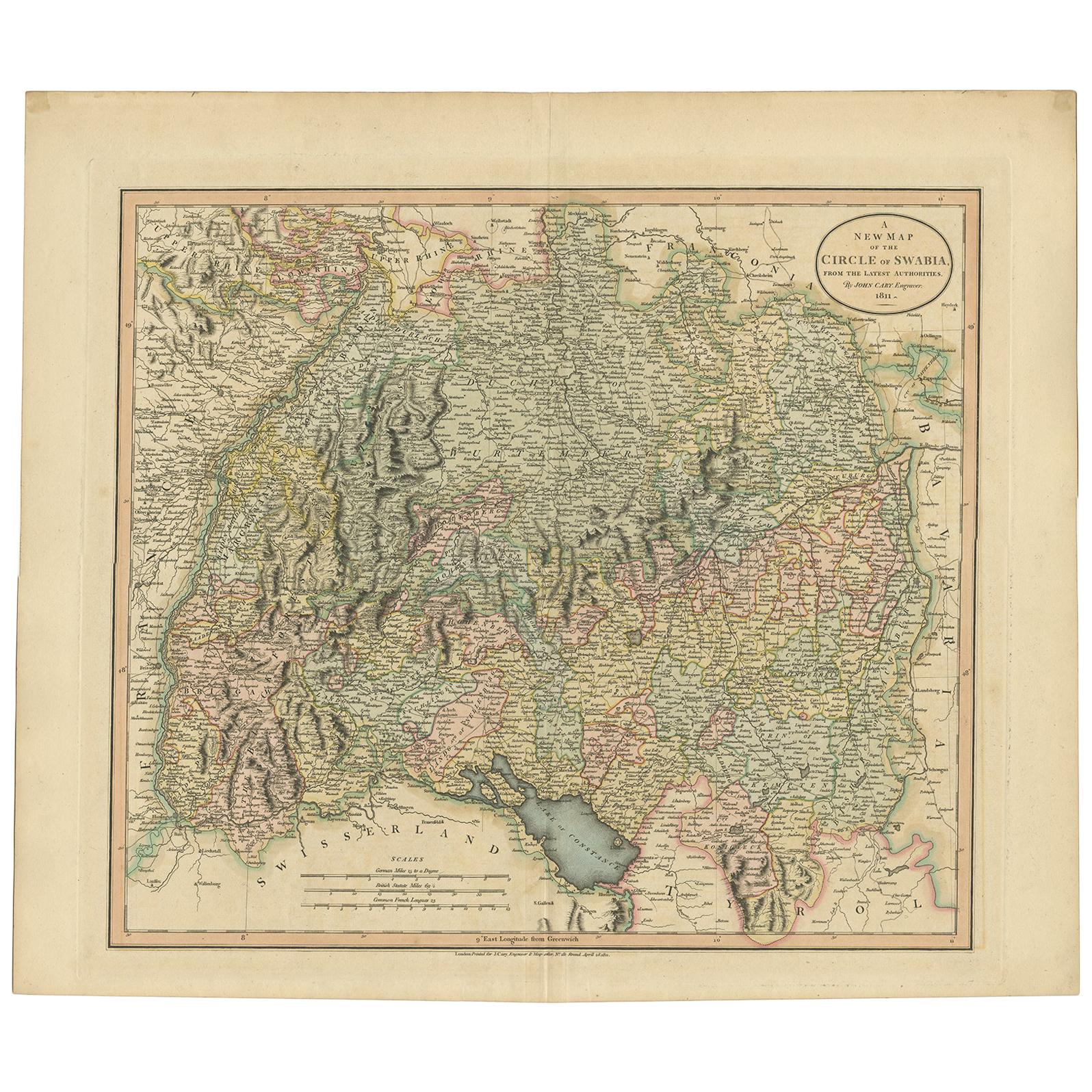
- Antique Map of the Swabia Region of Germany by Cary, '1811'By John CaryLocated in Langweer, NLAntique map titled 'A New Map of the Circle of Swabia'. Antique map of Swabia in Southwestern Germany. Covers from the Upper Rhine region south as far as Switzerland, Lake Constance ...Category
Antique Early 19th Century Maps
MaterialsPaper
- Antique Map of the Upper and Lower Rhine by Cary '1811'By John CaryLocated in Langweer, NLAntique map titled 'A New Map of the Circles of the Upper and Lower Rhine'. Antique map covering an area from Westphalia and Lower Saxony in the north to France and Swabia in the south.Category
Antique Early 19th Century Maps
MaterialsPaper
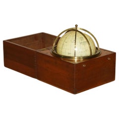
- John Cary Travel Celestial Globe in Box Marked Cary & Co London, No. 21540By John CaryLocated in GBWe are delighted to offer for sale this lovely John Cary Travel Celestial Globe in Box marked Cary & Co London, No. 21540 This globe I believe is classed as a 14 inch which is the...Category
Antique 19th Century English Victorian Scientific Instruments
MaterialsBrass