Items Similar to Antique Map of Northern Italy by J. Tallis, circa 1851


Want more images or videos?
Request additional images or videos from the seller
1 of 6
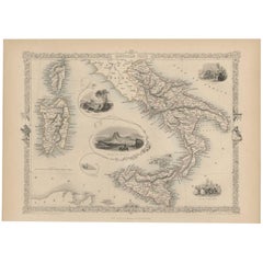
Antique Map of Northern Italy by J. Tallis, circa 1851
About the Item
A highly decorative mid-19th century map of Northern Italy which was drawn and engraved by John Rapkin (vignettes by A. H. Wray & J. B. Allen) and published in John Tallis & co.'s The Illustrated Atlas (London & New York: c.1851).
The Illustrated Atlas, published from 1849 to 1853, was the last decorative world atlas. The Northern Italy map was typical of the many fine ones which appeared in this work with its ornamental border and attractive vignettes. Illustrated are fine views of St. Peter's, Rome; the Grand Canal, Venice and a religious procession.
- Dimensions:Height: 10.44 in (26.5 cm)Width: 14.69 in (37.3 cm)Depth: 0.02 in (0.5 mm)
- Materials and Techniques:
- Period:
- Date of Manufacture:circa 1851
- Condition:Please study image carefully.
- Seller Location:Langweer, NL
- Reference Number:Seller: BG-033331stDibs: LU305439345261
About the Seller
5.0
Platinum Seller
These expertly vetted sellers are 1stDibs' most experienced sellers and are rated highest by our customers.
Established in 2009
1stDibs seller since 2017
Typical response time: <1 hour
- ShippingRetrieving quote...Ships From: Langweer, Netherlands
- Return PolicyA return for this item may be initiated within 14 days of delivery.
Auctions on 1stDibs
Our timed auctions are an opportunity to bid on extraordinary design. We do not charge a Buyer's Premium and shipping is facilitated by 1stDibs and/or the seller. Plus, all auction purchases are covered by our comprehensive Buyer Protection. Learn More
More From This SellerView All
- Antique Map of Southern Italy by J. Tallis, circa 1851Located in Langweer, NLDecorative and detailed mid-19th century map of Southern Italy which was drawn and engraved by John Rapkin (vignettes by A. H. Wray and J. Rogers...Category
Antique Mid-19th Century Maps
MaterialsPaper
- Antique Map of Belgium by J. Tallis, circa 1851Located in Langweer, NLA highly decorative and detailed mid-19th century map of Belgium which was drawn and engraved by J. Rapkin (vignettes by J. Marchant and J. B. Allen) an...Category
Antique Mid-19th Century Maps
MaterialsPaper
- Antique Map of Switzerland by J. Tallis, circa 1851Located in Langweer, NLA decorative and detailed mid-19th century map of Switzerland which was drawn and engraved by J. Rapkin (vignettes by A. H. Wray & J. B. Allen) and published in John Tallis's Illustr...Category
Antique Mid-19th Century Maps
MaterialsPaper
- Antique Map of the Northern Part of South America by J. Tallis, circa 1851Located in Langweer, NLA decorative and detailed mid-19th century map of the northern part of South America (including modern day Venezuela, Colombia, Ecuador, Guyana, Suriname and French Guiana) which was drawn and engraved by J. Rapkin (vignettes by H. Winkles & W. Lacey) and published in John Tallis & Co.'s The Illustrated Atlas (London & New York: circa 1851). The Illustrated Atlas, published from 1849 onwards, was the last decorative world atlas. The 'Venezuela, New Granada...' map was typical of the many Fine ones which appeared in this work with its decorative border and attractive vignettes. Illustrated are views of Mount Chimborazo, Ecuador; the 'Fall of the Bagota' (Tequendama Falls, Colombia); Rheas and a prospect of Paramaribo Harbour (Dutch Guiana...Category
Antique Mid-19th Century Maps
MaterialsPaper
- Antique Map of Asia Minor by J. Tallis, circa 1851Located in Langweer, NLA highly decorative mid-19th century map of 'Asia Minor' (modern day Turkey) which was drawn and engraved by J. Rapkin and published in John Tallis's Illust...Category
Antique Mid-19th Century Maps
MaterialsPaper
- Antique Map of Turkey in Asia by J. Tallis, circa 1851Located in Langweer, NLA highly decorative and finely engraved mid-19th century map of 'Turkey in Asia' (Middle Eastern part of the Ottoman Empire) which was engraved by J. Rapkin (vignettes by H. Warren &...Category
Antique Mid-19th Century Maps
MaterialsPaper


You May Also Like
- "San Francisco, Upper California” 1851 Antique Map of San FranciscoLocated in Colorado Springs, COThis is a pictorial lettersheet view of the city and harbor of San Francisco. This lithograph was printed on grey wove paper, across a double sheet, by famed lithographers Britton & ...Category
Antique 1850s American Prints
MaterialsPaper
- Antique Map of Italy by Andriveau-Goujon, 1843By Andriveau-GoujonLocated in New York, NYAntique Map of Italy by Andriveau-Goujon, 1843. Map of Italy in two parts by Andriveau-Goujon for the Library of Prince Carini at Palazzo Carini i...Category
Antique 1840s French Maps
MaterialsLinen, Paper
- Northern Scotland: A 17th Century Hand-colored Map by MercatorBy Gerard MercatorLocated in Alamo, CAThis is a framed hand-colored 17th century map of Northern Scotland by Gerard Mercator entitled "Scotiae pars Septentrionalis", published in Amsterdam in 1636. It is a highly detailed map of the northern part of Scotland, with the northwest Highlands and the cities Inverness and Aberdeen, as well as the Orkney Islands and the Hebrides. There is a decorative title cartouche in the upper left corner. The map is presented in an antiqued brown wood...Category
Antique 1630s Dutch Maps
MaterialsPaper
- Northern Scotland: A 16th Century Hand-colored Map by MercatorBy Gerard MercatorLocated in Alamo, CAA framed hand-colored 16th century map of Northern Scotland by Gerard Mercator entitled "Scotiae pars Septentrionalis", published in Amsterdam in 1636. It is a highly detailed map of the northern part of Scotland, with the northwest Highlands and the cities Inverness and Aberdeen, as well as the Orkney Islands and the Hebrides. There is a decorative title cartouche in the upper left corner. The map is presented in an antiqued brown wood...Category
Antique 16th Century Dutch Maps
MaterialsPaper
- Antique Map of Principality of MonacoBy Antonio Vallardi EditoreLocated in Alessandria, PiemonteST/619 - "Old Geographical Atlas of Italy - Topographic map of ex-Principality of Monaco" - ediz Vallardi - Milano - A somewhat special edition ---Category
Antique Late 19th Century Italian Other Prints
MaterialsPaper
- Large Antique 1859 Map of North AmericaLocated in Sag Harbor, NYThis Map was made by Augustus Mitchell in 1859 It is in amazing condition for being 163 years old. This price is for the rolled up easy to ship version of this piece. I will be Frami...Category
Antique Mid-19th Century American Maps
MaterialsCanvas, Paper


Recently Viewed
View AllMore Ways To Browse
Northern Furniture Co
J Allen
Map Of Rome
Map Rome
Rome Maps
Antique Maps Rome
Antique Map Rome
Antique Rome Map
Antique Map Of Rome
Rome Antique Map
Antique Map Of Northern Italy
Antique Maps Venice
Antique Venice Map
Antique Map Venice
Antique Map Of Venice
Maps Tallis
Antique Maps Of Rome
Antique Maps Of Venice Italy