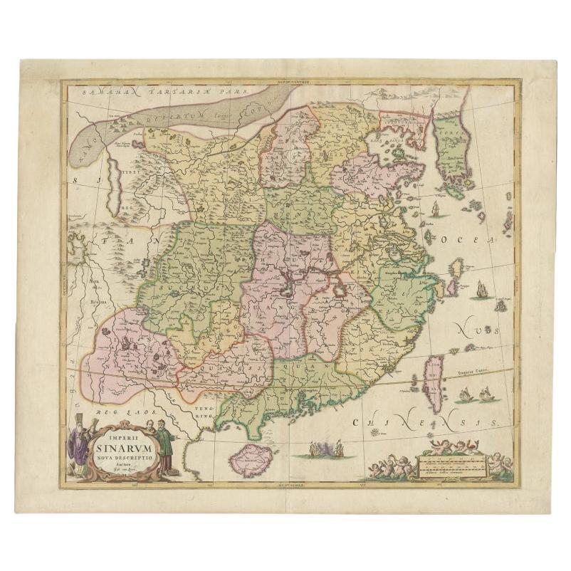
Items Similar to Beautiful Antique Map of China and Korea by Famous Mapmaker Janssonius, c.1660

Want more images or videos?
Request additional images or videos from the seller
1 of 5
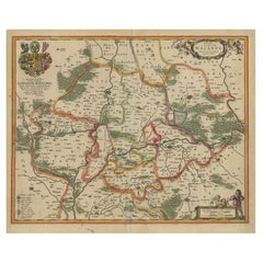
Beautiful Antique Map of China and Korea by Famous Mapmaker Janssonius, c.1660
About the Item
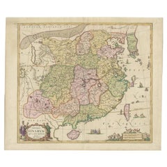
Antique map titled 'Imperii Sinarum Nova Descriptio'. Beautiful map of China and Korea. This map was published in Jansson's 'Atlas Maior'. Much detail troughout the map, including the Islands of Formosa and Hainan.
Artists and Engravers: Cartographer: Johan van Loon (ca.1612-1686).
Condition: Very good. General age-related toning, please study image carefully.
Date: c.1660
Overall size: 61.5 x 52 cm.
Image size: 52.5 x 47 cm.
We sell original antique maps to collectors, historians, educators and interior decorators all over the world. Our collection includes a wide range of authentic antique maps from the 16th to the 20th centuries. Buying and collecting antique maps is a tradition that goes back hundreds of years. Antique maps have proved a richly rewarding investment over the past decade, thanks to a growing appreciation of their unique historical appeal. Today the decorative qualities of antique maps are widely recognized by interior designers who appreciate their beauty and design flexibility. Depending on the individual map, presentation, and context, a rare or antique map can be modern, traditional, abstract, figurative, serious or whimsical. We offer a wide range of authentic antique maps for any budget.
- Dimensions:Height: 20.48 in (52 cm)Width: 24.22 in (61.5 cm)Depth: 0 in (0.01 mm)
- Materials and Techniques:
- Period:
- Date of Manufacture:circa 1660
- Condition:
- Seller Location:Langweer, NL
- Reference Number:
About the Seller
5.0
Platinum Seller
These expertly vetted sellers are 1stDibs' most experienced sellers and are rated highest by our customers.
Established in 2009
1stDibs seller since 2017
1,916 sales on 1stDibs
Typical response time: <1 hour
- ShippingRetrieving quote...Ships From: Langweer, Netherlands
- Return PolicyA return for this item may be initiated within 14 days of delivery.
More From This SellerView All
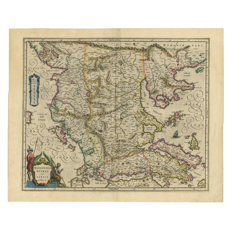
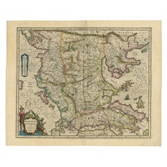
- Antique Map of Macedonia by the Famous Mapmaker Blaeu, c.1650Located in Langweer, NLAntique map titled 'Macedonia, Epirus et Achaia'. Ornated with a nice allegoric cartouche, one ship and a milage scale. Macedonia is shown in the centre of the map. With many detai...Category
Antique 17th Century Maps
MaterialsPaper
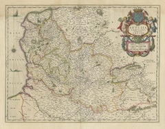
- Antique Map of China and Korea incl Formosa and Hainan, by Janssonius, ca.1650Located in Langweer, NLAntique map titled 'Imperii Sinarum Nova Descriptio'. Beautiful map of China and Korea, much detail troughout the map. Including the Islands of Formosa (Taiwan) and Hainan. The Great...Category
Antique 17th Century Maps
MaterialsPaper
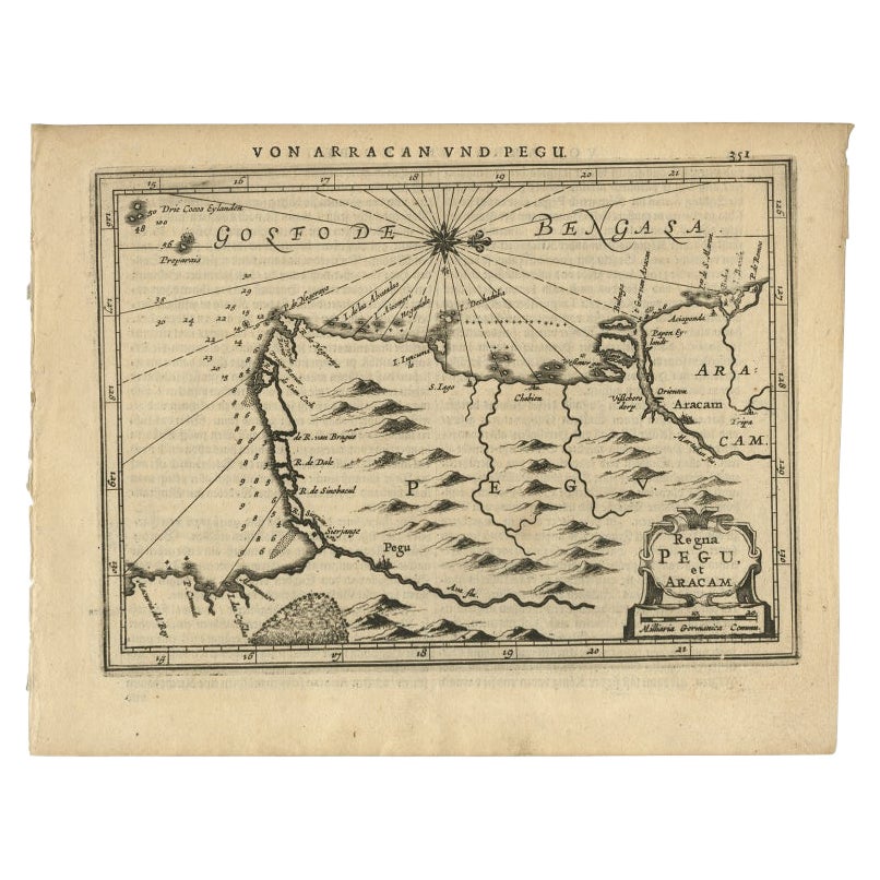
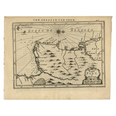
- Antique Map of Myanmar titled 'Regna Pegu et Aracam by Mapmaker Janssonius, 1651Located in Langweer, NLAntique map titled 'Regna Pegu et Aracam'. Beautiful map of part of Myanmar from Jansson's edition of Mercator's Atlas Minor. North to the right of map. Artists and Engravers: Johann...Category
Antique 17th Century Maps
MaterialsPaper
- Antique Map of Lower Silesia of The Famous Mapmaker Blaeu, c.1650Located in Langweer, NLAntique map titled 'Ducatus Silesiae Wolanus'. \ Antique map depicting lower Silesia with the cities of Wolow (Wohlau), Winsko (Winzig), Herrnstadt, Chobie (Koben), Lubin (Lüben), R...Category
Antique 17th Century Maps
MaterialsPaper
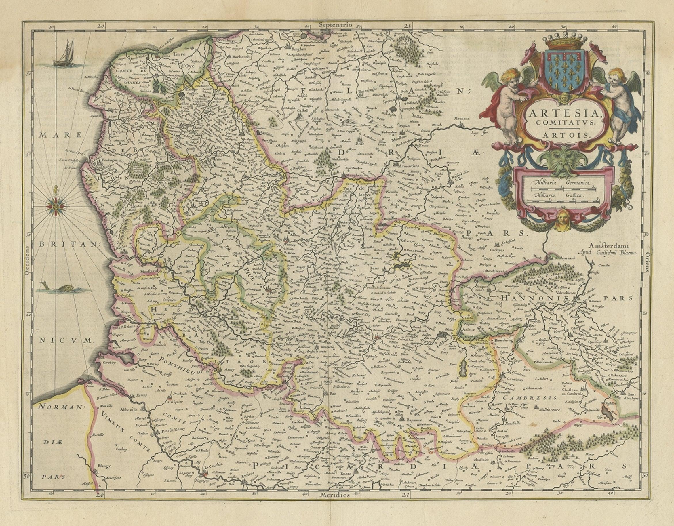
- Antique Map of Artois in the North of France by Famous Mapmaker Blaeu, c.1640Located in Langweer, NLAntique map titled 'Artesia Comitatus Artois'. Map of Artois or Artesia, France. Artois is former province located in the northwestern part of France, boarding Belgium (Flanders) on ...Category
Antique 17th Century Maps
MaterialsPaper
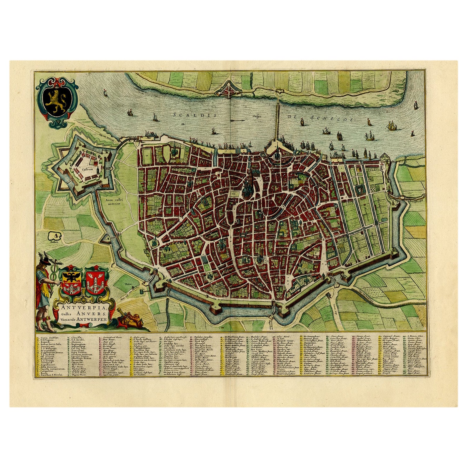
- Beautiful Original Antique Map of Antwerp, Belgium by Mapmaker Blaeu, ca.1652Located in Langweer, NLDescription: Antique map titled 'Antverpia; Gallis Anvers. Vernacule Antwerpen.' A very nicely coloured plan of Antwerp in Flanders, Belgium. West-oriented, with the river Scheld...Category
Antique 1650s Maps
MaterialsPaper
You May Also Like
- 1657 Janssonius Map of Vermandois and Cappelle, Ric. A-004Located in Norton, MA1657 Janssonius map of Vermandois and Cappelle Ric.a004 Description: Antique map of France titled 'Descriptio Veromanduorum - Gouvernement de la Cappelle'. Two detailed maps o...Category
Antique 17th Century Unknown Maps
MaterialsPaper
- Original Antique Map of China by Thomas Clerk, 1817Located in St Annes, LancashireGreat map of China Copper-plate engraving Drawn and engraved by Thomas Clerk, Edinburgh. Published by Mackenzie And Dent, 1817 Unframed.Category
Antique 1810s English Maps
MaterialsPaper
- Original Antique Map of China, Arrowsmith, 1820Located in St Annes, LancashireGreat map of China Drawn under the direction of Arrowsmith Copper-plate engraving Published by Longman, Hurst, Rees, Orme and Brown, 1820 Unfr...Category
Antique 1820s English Maps
MaterialsPaper
- 17th Century Hand-Colored Map of a Region in West Germany by JanssoniusBy Johannes JanssoniusLocated in Alamo, CAThis attractive highly detailed 17th century original hand-colored map is entitled "Archiepiscopatus Maghdeburgensis et Anhaltinus Ducatus cum terris adjacentibus". It was published ...Category
Antique Mid-17th Century Dutch Maps
MaterialsPaper
- Framed Map of ChinaLocated in Greenwich, CTMap of China, 19th century. European print map of China Conservation frame with walnut frame Overall dimension : 28 1/2" wide 31" high 2" depth with fra...Category
Antique 19th Century European Qing Prints
MaterialsPaper
- Large Original Antique Map of China, Fullarton, C.1870Located in St Annes, LancashireGreat map of China From the celebrated Royal Illustrated Atlas Lithograph by Swanston. Original color. Published by Fullarton, Edinburgh. C.1870 Repairs to minor edge te...Category
Antique 1870s Scottish Maps
MaterialsPaper


Recently Viewed
View AllMore Ways To Browse
China Map
Chinese Maps
Chinese Map
Map Of China
Chinese Hundred Antiques
Korea Antique Furniture
Korean Antiques
Korean Traditional Furniture
Korean Traditional
Antique Chinese 16th
16th Century Chinese Antiques
Korean Rare
Antique China Map
Antique Map China
Antique Chinese Maps
Antique Map Of China
Antique Maps Of China
Antique Furniture From Korea