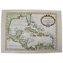
Gulf of Mexico, Florida, C. America, Cuba, etc.: 18th C. Hand-colored Bellin Map
View Similar Items


Want more images or videos?
Request additional images or videos from the seller
1 of 9
Gulf of Mexico, Florida, C. America, Cuba, etc.: 18th C. Hand-colored Bellin Map
About the Item
- Creator:Jacques-Nicolas Bellin (Artist)
- Dimensions:Height: 12.63 in (32.09 cm)Width: 18 in (45.72 cm)Depth: 0.13 in (3.31 mm)
- Materials and Techniques:Paper,Engraved
- Place of Origin:
- Period:
- Date of Manufacture:1757
- Condition:Wear consistent with age and use.
- Seller Location:Alamo, CA
- Reference Number:Seller: # 28181stDibs: LU5206226631232
About the Seller
5.0
Vetted Seller
These experienced sellers undergo a comprehensive evaluation by our team of in-house experts.
1stDibs seller since 2020
12 sales on 1stDibs
More From This SellerView All
- Captain Cook's Exploration of Tahiti 18th C. Hand-Colored Map by BellinBy Jacques-Nicolas BellinLocated in Alamo, CAThis beautiful 18th century hand-colored copper plate engraved map is entitled "Carte de l'Isle de Taiti, par le Lieutenant J. Cook" was created by Jacques Nicolas Bellin and publish...Category
Antique Mid-18th Century French Maps
MaterialsPaper
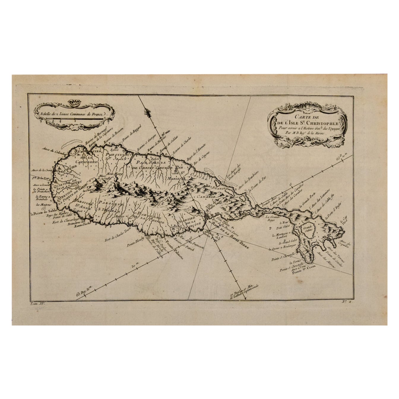
- St. Christophe 'St. Kitts' Island: An 18th Century Hand-colored Map by BellinBy Jacques-Nicolas BellinLocated in Alamo, CAJacques Bellin's copper-plate map of the Caribbean island of Saint Kitts entitled "Carte De De l'Isle St. Christophe Pour servir á l'Histoire Genle. des V...Category
Antique Mid-18th Century French Maps
MaterialsPaper
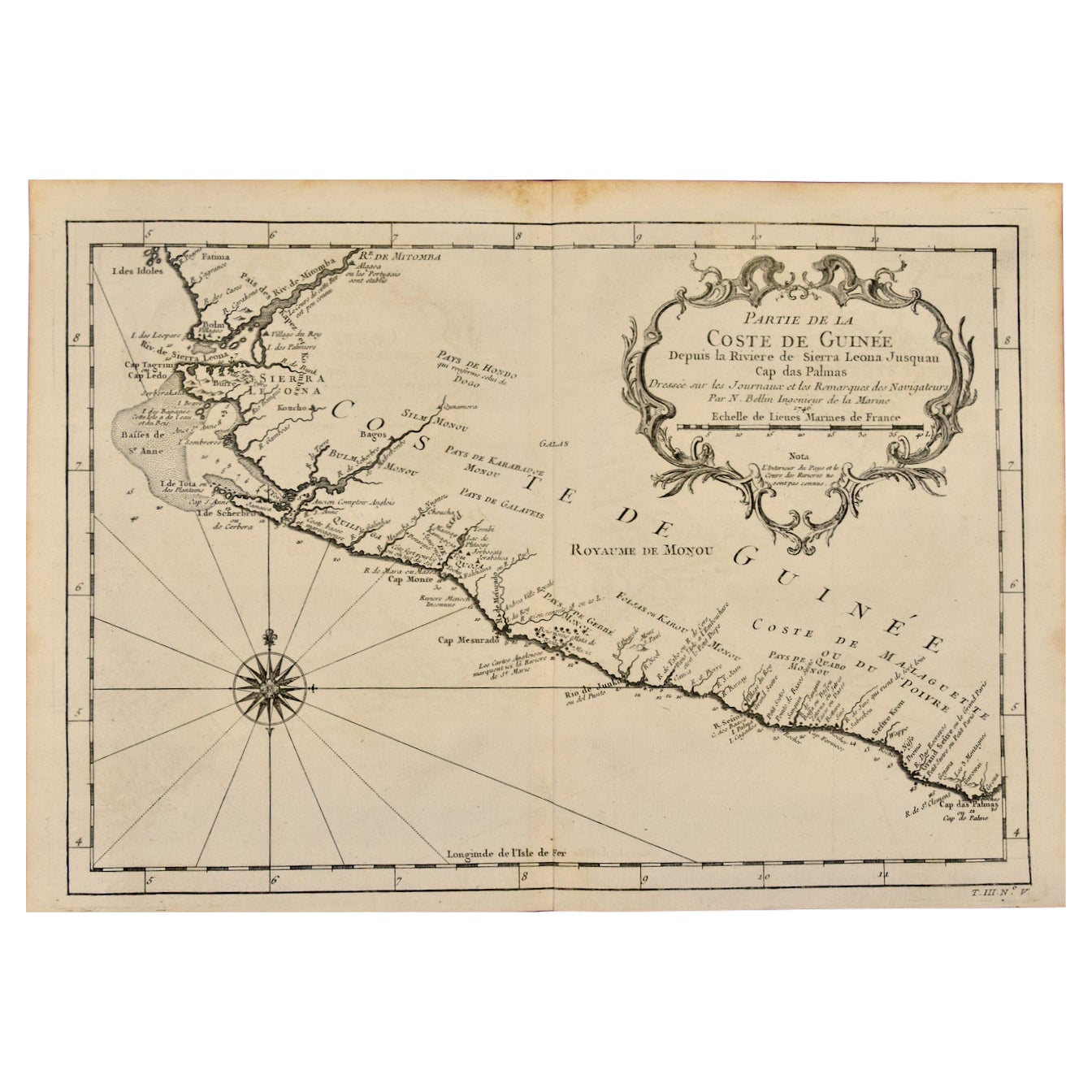
- West Coast of Africa, Guinea & Sierra Leone: An 18th Century Map by BellinBy Jacques-Nicolas BellinLocated in Alamo, CAJacques Bellin's copper-plate map entitled "Partie de la Coste de Guinee Dupuis la Riviere de Sierra Leona Jusquau Cap das Palmas", depicting the coast of Guinea and Sierra Leone in ...Category
Antique Mid-18th Century French Maps
MaterialsPaper
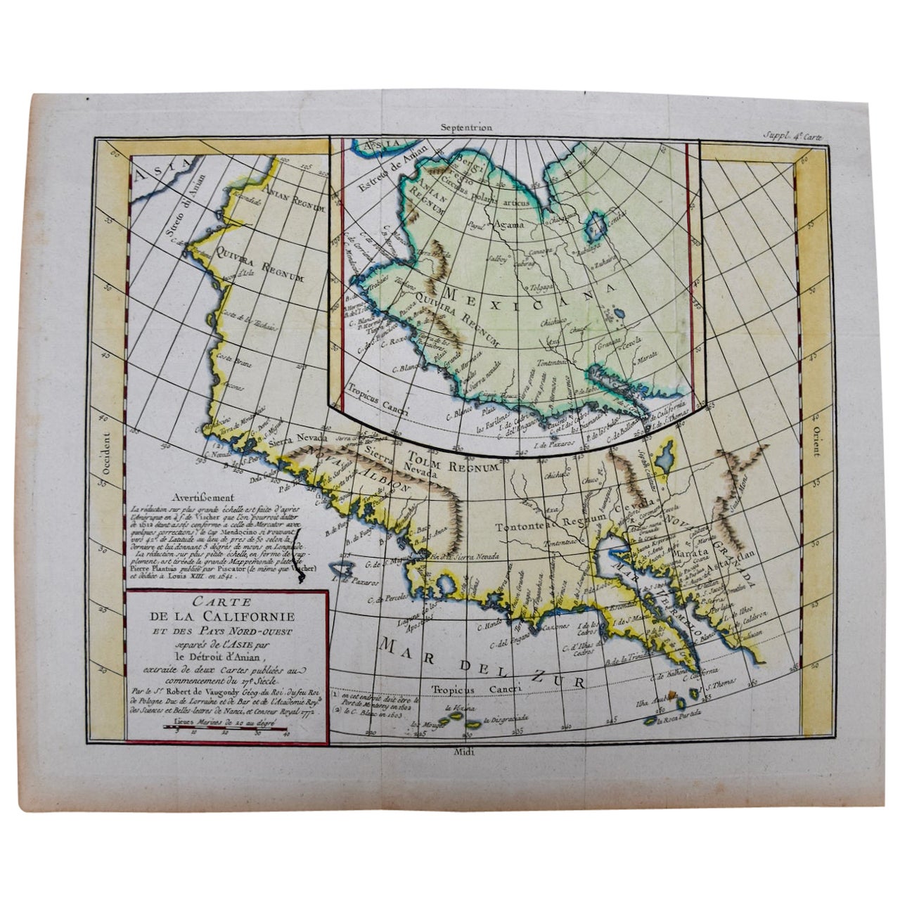
- California, Alaska and Mexico: 18th Century Hand-Colored Map by de VaugondyBy Didier Robert de VaugondyLocated in Alamo, CAThis an 18th century hand-colored map of the western portions of North America entitled "Carte de la Californie et des Pays Nord-Ouest separés de l'Asie par le détroit d'Anian, extra...Category
Antique 1770s French Maps
MaterialsPaper
- South America: Hand-colored 18th Century Framed Map by Thomas JefferysBy Thomas JefferysLocated in Alamo, CAThis detailed hand-colored map of South America by Thomas Jefferys was published in London in 1750. The map shows countries, early colonial possessions, towns, rivers, mountains, and...Category
Antique Mid-18th Century English Maps
MaterialsPaper
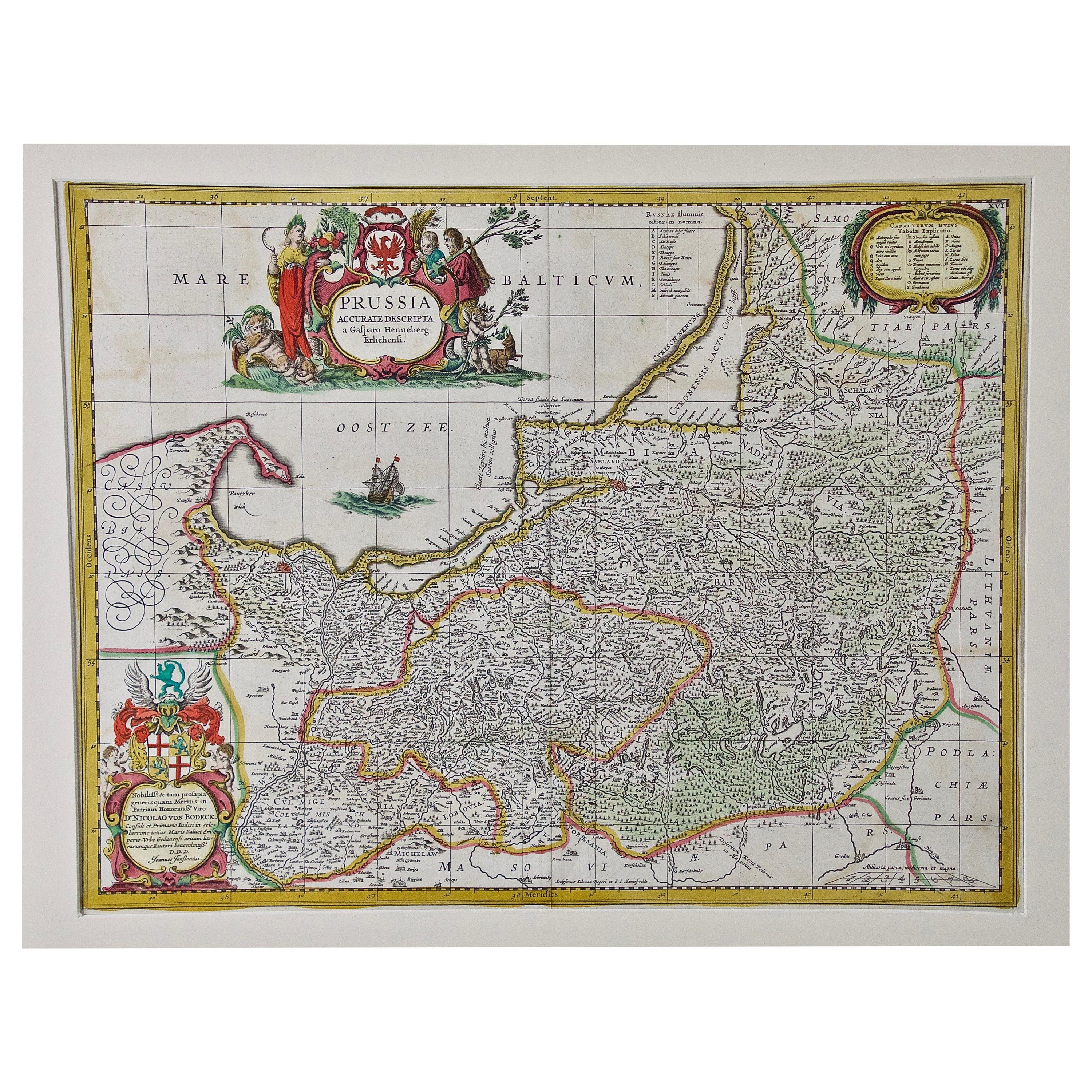
- Prussia, Poland, N. Germany, Etc: A Hand-colored 17th Century Map by JanssoniusBy Johannes JanssoniusLocated in Alamo, CAThis is an attractive hand-colored copperplate engraved 17th century map of Prussia entitled "Prussia Accurate Descripta a Gasparo Henneberg Erlichensi", published in Amsterdam by Joannes Janssonius in 1664. This very detailed map from the golden age of Dutch cartography includes present-day Poland, Latvia, Lithuania, Estonia and portions of Germany. This highly detailed map is embellished by three ornate pink, red, mint green and gold...Category
Antique Mid-17th Century Dutch Maps
MaterialsPaper


You May Also Like
- Engraving of a Map of Florida, the Gulf Coast, Caribbean & Central America, 1728Located in Langweer, NLThis exceptional antique map, titled "Nouvelle Carte Marine de Toute les Cotes de l´Amerique" and alternatively known as "Nieuwe groote en seer Curieuse Paskaart van Geheel-WestIndie...Category
Antique Mid-18th Century European Maps
MaterialsPaper
 $12,228 Sale Price25% OffFree Shipping
 - Antique Map of the Gulf of Bengal by J.N. Bellin, circa 1760Located in Langweer, NLBeautiful chart of the Gulf of Bengal. The map extends from Malabar to Sumatra and today Phuket area in Thailand. Including Pegu, Ceylon, and the Andaman and Nicobar Islands. Numerou...Category
Antique Mid-18th Century Maps
MaterialsPaper
 $298 Sale Price20% Off
 - Antique Map of Celebes 'Sulawesi, Indonesia' by Bellin, ciarca 1755By Jacques-Nicolas BellinLocated in Langweer, NLAntique map titled 'Carte de l'Isle Celebes ou Macassar'. Map of Celebes (Sulawesi, Indonesia), showing Makassar, which was the most important trading city of eastern Indonesia in th...Category
Antique Mid-18th Century European Maps
MaterialsPaper
 $130 Sale Price20% Off
 - Antique Map of Tartary and Northeast Asia by Bellin, circa 1750By Jacques-Nicolas BellinLocated in Langweer, NLAntique map titled 'Carte de la Tartarie Occidentale'. Map of Tartary and northeast Asia, from Lake Baykal, Partie du Siberia in the north, Pays des Kalkas at the center, as well as ...Category
Antique Mid-18th Century European Maps
MaterialsPaper
- Antique Map of Siberia by Bellin, 1754Located in Langweer, NLAntique map titled 'Carte de la Siberie'. Detailed map of Siberia, extending from the White Sea and the Caspian Sea in the west to Irkuckoi Province, Jakutky on the Lena River and regions just to the east. Centered on the Jenisi River. Originates from Prévost's 'Histoire Générale des Voyages'. Artists and Engravers: Jacques-Nicolas Bellin (1703-1772) was among the most important mapmakers of the eighteenth century. In 1721, at age 18, he was appointed hydrographer (chief cartographer) to the French Navy. In August 1741, he became the first Ingénieur de la Marine of the Depot des cartes...Category
Antique 18th Century Maps
MaterialsPaper
- Original Hand-Colored Antique Map of America by Danckerts, circa 1680Located in Langweer, NLAntique map titled 'Novissima et Accuratissima Totius Americae Descriptio per I. Danckerts'. Striking map of America. California is shown as an island, Based Upon Sanson's model. The Great Lakes are shown with an open western coastline. No Northwestern Coast beyond 40 degrees. The seven cities of Cibola appear in the Southwestern US. The conception of the Mississippi River is still very vague and pushed far west of its true mouth. The large lake in the Southeastern US first seen on Le Moyne's map is still present. South America retains its excessively wide format. A hopeful extension from Button's Bay is shown portending a possible Northwest Passage. The map is richly embellished with two cartouches, 9 sailing vessels and elaborate vignettes of native villages, native warriors...Category
Antique Late 17th Century Maps
MaterialsPaper
 $3,043 Sale Price20% Off


Recently Viewed
View AllMore Ways To Browse
Antique Aztec
18th Century French Army
Used Furniture Bahamas
Antique Florida Collectibles
West Indies Map
Map Of West Indies
Central America Map
West Indies Antique Map
Antique Maps West Indies
Upper Peninsula
Dutch Caribbean
Jean Jacques Rousseau
Mayan Antique
Antique Florida Map
Antique Map Florida
Antique Maps Florida
Antique Florida Maps
Antique Maps Of Florida