Items Similar to Large Antique Map of France by De Wit, c.1680


Want more images or videos?
Request additional images or videos from the seller
1 of 6
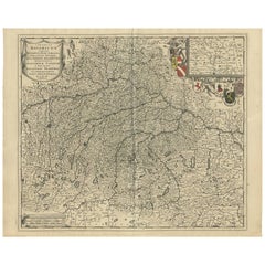
Large Antique Map of France by De Wit, c.1680
About the Item
Antique map titled 'Accuratissima Galliae Tabula vulgo Royaume de France'. Detailed map of France. Shows provinces, cities, rivers etc.
Artists and Engravers: Frederick de Wit (1629 ca.-1706) was a mapmaker and mapseller who was born in Gouda but who worked and died in Amsterdam. He moved to the city in 1648, where he opened a printing operation under the name of The Three Crabs; later, he changed the name of his shop to The White Chart. From the 1660s onward, he published atlases with a variety of maps; he is best known for these atlases and his Dutch town maps. After Frederik’s death in 1706, his wife Maria ran the shop for four years before selling it. Their son, Franciscus, was a stockfish merchant and had no interest in the map shop. At the auction to liquidate the de Wit stock, most of the plates went to Pieter Mortier, whose firm eventually became Covens & Mortier, one of the biggest cartography houses of the eighteenth century.
Condition: Fair, age-related toning. Repair on folding line and near the English channel. Some other wear and minor defects. Blank verso, please study image carefully.
Date: c.1680
Overall size: 60.5 x 52 cm.
Image size: 58 x 49 cm.
We sell original antique maps to collectors, historians, educators and interior decorators all over the world. Our collection includes a wide range of authentic antique maps from the 16th to the 20th centuries. Buying and collecting antique maps is a tradition that goes back hundreds of years. Antique maps have proved a richly rewarding investment over the past decade, thanks to a growing appreciation of their unique historical appeal. Today the decorative qualities of antique maps are widely recognized by interior designers who appreciate their beauty and design flexibility. Depending on the individual map, presentation, and context, a rare or antique map can be modern, traditional, abstract, figurative, serious or whimsical. We offer a wide range of authentic antique maps for any budget.
- Creator:Frederick de Wit (Maker)
- Dimensions:Height: 20.48 in (52 cm)Width: 23.82 in (60.5 cm)Depth: 0 in (0.01 mm)
- Materials and Techniques:
- Period:
- Date of Manufacture:circa 1680
- Condition:
- Seller Location:Langweer, NL
- Reference Number:
About the Seller
5.0
Platinum Seller
These expertly vetted sellers are 1stDibs' most experienced sellers and are rated highest by our customers.
Established in 2009
1stDibs seller since 2017
1,913 sales on 1stDibs
Typical response time: <1 hour
- ShippingRetrieving quote...Ships From: Langweer, Netherlands
- Return PolicyA return for this item may be initiated within 14 days of delivery.
More From This SellerView All
- Antique Map of Denmark by F. de Wit, 1680Located in Langweer, NLAntique map titled 'Dania Regnum'. Large, attractive map of Denmark, Sleschwig-Holstein and southern Sweden. Good detail throughout. Embellished with a title cartouche with the Danis...Category
Antique Late 17th Century Maps
MaterialsPaper
- Antique Map of Flanders 'Belgium' by F. de Wit, circa 1680Located in Langweer, NLAntique map titled 'Comitatus Flandriae Tabula, in Lucem Edita'. Large map of Flanders, Belgium. Published by F. de Wit, circa 1680.Category
Antique Late 17th Century Maps
MaterialsPaper
- Antique Map of South Sweden 'Scandinavia' by F. de Wit, 1680Located in Langweer, NLAntique map titled 'Accurata Scaniae, Blekingae et Hallandiae Descriptio per F. de Wit Amstelodami'. This map shows South Sweden with an inset of Halmstad and vicinity. Contemporary ...Category
Antique Late 17th Century Maps
MaterialsPaper
- Antique Map of Southern Germany by F. de Wit, circa 1680Located in Langweer, NLThis antique map depicts a portion of southern Germany that included the historic regions of Bavaria, the Palatinate, Prussia-Brandenburg, the Rhineland and Saxony. Regensberg, Freis...Category
Antique Late 17th Century Maps
MaterialsPaper
- Antique Map of Belgium and Northern France by F. de Wit, circa 1680Located in Langweer, NLAntique map titled 'Belgii Regii Accuratissima Tabula Pluribus Locis Recens Emen'. Large map of Belgium and Northern France. Published by F. de Wit, circa 1680.Category
Antique Late 17th Century Maps
MaterialsPaper
- Antique Map of the Namur Region 'France' by F. de Wit, circa 1680Located in Langweer, NLAntique map titled 'Comitatus Namurci Tabula in Lucem Edita'. Large map of the Namur region, France. Published by F. de Wit, circa 1680.Category
Antique Late 17th Century Maps
MaterialsPaper


You May Also Like
- Large 17th Century Hand Colored Map of England and the British Isles by de WitBy Frederick de WitLocated in Alamo, CAA large hand colored 17th century map of England and the British Isles by Frederick de Wit entitled "Accuratissima Angliæ Regni et Walliæ Principatus", published in Amsterdam in 1680. It is a highly detailed map of England, Scotland, the Scottish Isles...Category
Antique Late 17th Century Dutch Maps
MaterialsPaper
- Germany West of the Rhine: A Hand-colored 18th Century Map by de WitBy Frederick de WitLocated in Alamo, CAThis original 18th century hand-colored map of the county of Moers, Germany entitled "Illustrissimo Celsissmo Principi GUILIELMO HENRICO D.G. Arausionum Principi Domino suo Clementis...Category
Antique Early 18th Century Dutch Maps
MaterialsPaper
- Large Antique 1859 Map of North AmericaLocated in Sag Harbor, NYThis Map was made by Augustus Mitchell in 1859 It is in amazing condition for being 163 years old. This price is for the rolled up easy to ship version of this piece. I will be Frami...Category
Antique Mid-19th Century American Maps
MaterialsCanvas, Paper

- Persia, Armenia & Adjacent Regions: A 17th Century Hand-colored Map by De WitBy Frederick de WitLocated in Alamo, CAA large 17th century hand colored copperplate engraved map entitled "Novissima nec non Perfectissima Scandinaviae Tabula comprehendens Regnorum Sueciae, Daniae et Norvegiae distincte...Category
Antique Late 17th Century Dutch Maps
MaterialsPaper
- Original Antique Map of France, Arrowsmith, 1820Located in St Annes, LancashireGreat map of France Drawn under the direction of Arrowsmith. Copper-plate engraving. Published by Longman, Hurst, Rees, Orme and Brown, 1820 Unframed.Category
Antique 1820s English Maps
MaterialsPaper
- Antique Map of Italy by Andriveau-Goujon, 1843By Andriveau-GoujonLocated in New York, NYAntique Map of Italy by Andriveau-Goujon, 1843. Map of Italy in two parts by Andriveau-Goujon for the Library of Prince Carini at Palazzo Carini i...Category
Antique 1840s French Maps
MaterialsLinen, Paper


Recently Viewed
View AllMore Ways To Browse
Antique Shop Collectables
Antique And Collectible Shop
Frederick Antique Furniture
Large French Antique Plate
Antique Shop Interiors
Antique Shop Interior
Large Map Of The World
Antique English 17th Century
16th Century English Antique
Large Maps On Paper
Antique Curiosity Shop
Rare Map France
French 17th C Furniture
French Antique Furniture Auctions
Antique English Maps
Antique Town Maps
17th C English
Large World Map