Items Similar to Antique Genealogy Chart of the Valois House in France, 1732
Want more images or videos?
Request additional images or videos from the seller
1 of 7
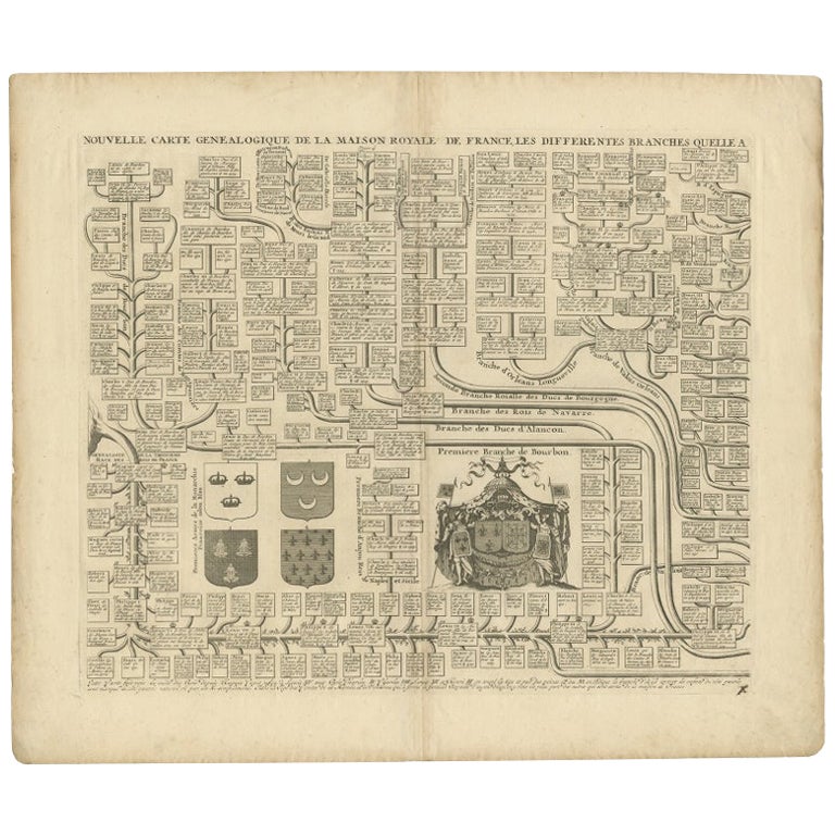
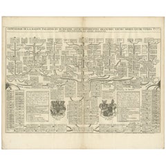
Antique Genealogy Chart of the Valois House in France, 1732
About the Item
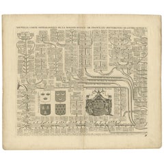
Antique print titled 'Nouvelle Carte Genealogique des Branches du Cote Gauche (..)'.
Set of two prints with a chart of the left branch of the genealogy of the Valois House, and the various branches formed through alliances, each with its coat of arms including the Counts and Dukes of Alencon, Anjou, Naples, Calabria, Burgundy, Brabant. With inset engraved views of the Hotel des Invalides in Paris, the Trianon, Versailles and St. Cloud. This print orginates from 'Atlas Historique'.
The House of Valois[a] was a cadet branch of the Capetian dynasty. They succeeded the House of Capet (or "Direct Capetians") to the French throne, and were the royal house of France from 1328 to 1589. Junior members of the family founded cadet branches in Orléans, Anjou, Burgundy, and Alençon.
The Valois descended from Charles, Count of Valois (1270–1325), the second surviving son of King Philip III of France (reigned 1270–1285). Their title to the throne was based on a precedent in 1316 (later retroactively attributed to the Merovingian Salic law) which excluded females (Joan II of Navarre), as well as male descendants through the distaff side (Edward III of England), from the succession to the French throne.
After holding the throne for several centuries the Valois male line failed and the House of Bourbon succeeded the Valois to the throne as the senior-surviving branch of the Capetian dynasty.
Artists and Engravers: Henri Abraham Chatelain (1684-1743), his father Zacharie Chatelain (d.1723) and Zacharie Junior (1690-1754), worked as a partnership publishing the Atlas Historique.
Antique prints have long been appreciated for both their aesthetic and investment value. They were the product of engraved, etched or lithographed plates. These plates were handmade out of wood or metal, which required an incredible level of skill, patience and craftsmanship. Whether you have a house with Victorian furniture or more contemporary decor an old engraving can enhance your living space.
- Dimensions:Height: 18.78 in (47.7 cm)Width: 23.23 in (59 cm)Depth: 0 in (0.01 mm)
- Sold As:Set of 2
- Materials and Techniques:
- Period:
- Date of Manufacture:1732
- Condition:Repaired: Repair on folding line. Condition: Good, general age-related toning. Repair on folding line and minor defects, please study image carefully.
- Seller Location:Langweer, NL
- Reference Number:
About the Seller
5.0
Platinum Seller
These expertly vetted sellers are 1stDibs' most experienced sellers and are rated highest by our customers.
Established in 2009
1stDibs seller since 2017
1,913 sales on 1stDibs
Typical response time: <1 hour
- ShippingRetrieving quote...Ships From: Langweer, Netherlands
- Return PolicyA return for this item may be initiated within 14 days of delivery.
More From This SellerView All
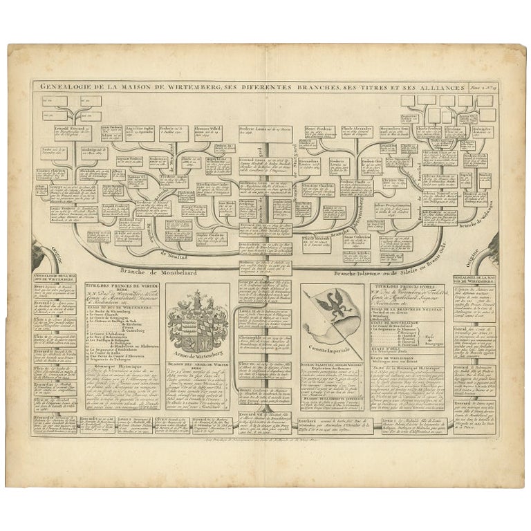
- Antique Genealogy Chart of the House of Wurttemberg in Germany, 1732Located in Langweer, NLAntique print titled 'Genealogie de la Maison de Wirtemberg (..)'. Genealogy of the House Wurttemberg. This print orginates from 'Atlas Historique'. The House of Württemberg is a...Category
Antique 18th Century Prints
MaterialsPaper
- Two Antique Genealogy Charts of the Royal House of France, Coats of Arms, 1732Located in Langweer, NLAntique print titled 'Nouvelle Carte Genealogique de la Maison Royale de France (..)'. Set of two prints depicting a genealogical chart of the Royal ...Category
Antique 18th Century Prints
MaterialsPaper
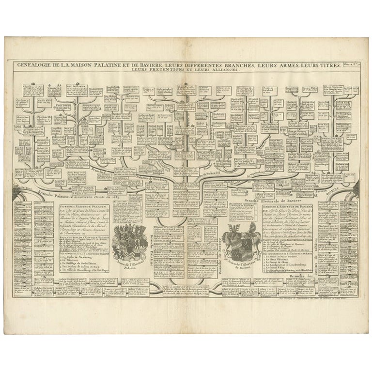
- Antique Genealogy Chart of Palatinate & Bavarian Houses with Coats of Arms, 1732Located in Langweer, NLAntique print titled 'Genealogie de la Maison Palatine (..)'. Chart of the genealogy of the Palatinate (Die Pfalz) and Bavarian (Baiern) Houses. Shows the coats of arms of both Elect...Category
Antique 18th Century Prints
MaterialsPaper
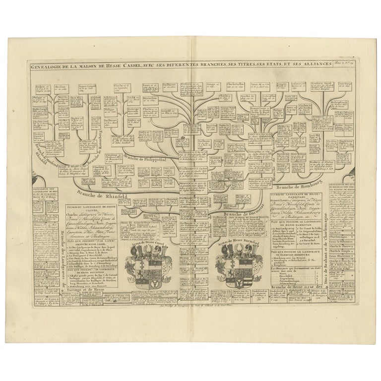
- Antique Genealogy Chart of the Landgraviate Hessen-Kassel, Germany, 1732Located in Langweer, NLAntique print titled 'Genealogie de la Maison de Hesse Cassel'. Chart of the genealogy of the Landgraviate Hessen-Kassel / Hesse-Cassel. This includes the coats of arms of both Hesse-Cassel and Hesse-Darmstadt. This print orginates from 'Atlas Historique'. The Landgraviate of Hesse-Kassel (German: Landgrafschaft Hessen-Kassel), spelled Hesse-Cassel during its entire existence, was a state in the Holy Roman Empire that was directly subject to the Emperor. The state was created in 1567 when the Landgraviate of Hesse was divided upon the death of Philip I, Landgrave of Hesse. His eldest son William IV inherited the northern half of the Landgraviate and the capital of Kassel. The other sons received the Landgraviate of Hesse-Marburg, the Landgraviate of Hesse-Rheinfels and the Landgraviate of Hesse-Darmstadt. During the Napoleonic reorganisation of the Empire in 1803, the Landgrave of Hesse-Kassel was elevated to an Electorate and Landgrave William IX became an Imperial Elector. Many members of the Hesse-Kassel House served in the Danish military gaining high ranks and power in the Oldenburg realm due to the fact that many Landgraves were married to Danish princesses...Category
Antique 18th Century Prints
MaterialsPaper
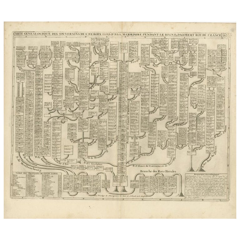
- Antique Genealogy Chart of the Leaders of Europe by Chatelain, 1732Located in Langweer, NLAntique print titled 'Carte Genealogique des Souverains de l'Europe (..)'. Chart of the royal line of the great Frankish major, Aega. As early as the 14th century the Hapsburgs attem...Category
Antique 18th Century Prints
MaterialsPaper
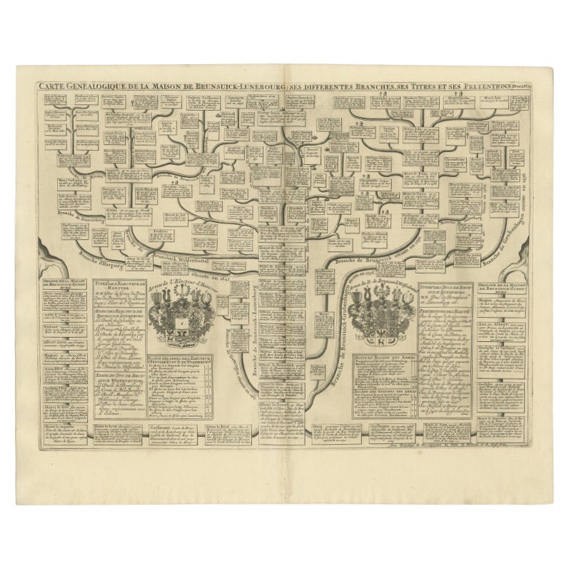
- Antique Genealogy Chart of the Duchy of Brunswick-Luneburg, Germany, 1732Located in Langweer, NLAntique print titled 'Carte Genealogique de la Maison de Brunsuick-Lunebourg'. Genealogy of the Duchy of Brunswick-Luneburg. With coats of arms of the Elector of Hannover and the Duc...Category
Antique 18th Century Prints
MaterialsPaper
You May Also Like
- Antique Anatomical Wall Chart Depicting the Human SkeletonLocated in Berghuelen, DEA rare 19th century anatomical wall chart depicting the human skeleton. On the sides On the sides are detailed description in German language. The wall...Category
Early 20th Century German Victorian Prints
MaterialsPaper
- “The Restaurant of the House of Representatives” Engraving by Harper's WeeklyLocated in Colorado Springs, COThis original wood engraving is titled “The Restaurant of the House of Representatives, Washington, DC.” It was published as a double-page image, in the August 12, 1893 issue of the famous 19th century newspaper Harper’s Weekly. The print was illustrated by Charles Stanley Reinhardt. The House Restaurant, a unique part of life in the Capitol, has been in the same location since the 1857 Capitol Expansion. Congressional members’ busy work schedule made the availability of food on site a necessity. But the restaurant also served as an informal meeting spot for members to continue conversations and deal making. This 1893 print illustrates the convivial atmosphere. Details including elegantly dressed tables...Category
Antique 1890s American Prints
MaterialsPaper
- Antique Foldable Anatomical Wall Chart Depicting Human MusculatureLocated in Berghuelen, DEAntique Foldable Anatomical Wall Chart Depicting Human Musculature The rare 19th century anatomical wall chart depicts the human musculature and inter...Category
Early 20th Century German Victorian Prints
MaterialsWood, Paper
- Anatomical Wall Chart Depicting the Human Lymphatic and Blood VesselsLocated in Berghuelen, DEA rare 19-carat anatomical wall chart depicting the human lymphatic and blood vessels. On the sides with detailed description in German language. Print...Category
Early 20th Century German Victorian Prints
MaterialsPaper
- Genito-Urinary Anatomical Chart Fritz FrohseBy Nystrom / Frohse Art, Fritz FrohseLocated in Philadelphia, PAGenito-Urinary Anatomical Chart by Fritz Frohse. Dated 1922. Paper mounted on canvas. Shows wear but still presents very well!Category
Vintage 1920s German American Classical Prints
MaterialsCanvas, Paper
- Original Antique Map of France, Arrowsmith, 1820Located in St Annes, LancashireGreat map of France Drawn under the direction of Arrowsmith. Copper-plate engraving. Published by Longman, Hurst, Rees, Orme and Brown, 1820 Unframed.Category
Antique 1820s English Maps
MaterialsPaper


