Items Similar to 17th Century John Speed Map of Kent with Her Cities & Earles Described, C.1676

Want more images or videos?
Request additional images or videos from the seller
1 of 19
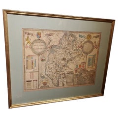
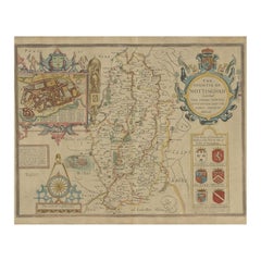
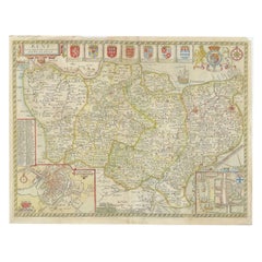
17th Century John Speed Map of Kent with Her Cities & Earles Described, C.1676
About the Item
Antique 17th century British very rare and original John Speed (1551-1629) map of Kent with her Cities and Earles described and observed, Thomas Bassett & Richard Chiswell, publication 1676, hand-coloured engraved map, map measuring 380mm x 505mm, English text on reverse, mounted in gilt and solid wood frame with glazed front. John Speed is undoubtedly the most famous single figure in the early history of the English map making.
Condition:
In good condition, wear as expected with age and comes newly framed.
Size:
Height 66cm
Width 88cm.
- Creator:John Speed (Maker)
- Dimensions:Height: 25.99 in (66 cm)Width: 34.65 in (88 cm)Depth: 0.79 in (2 cm)
- Materials and Techniques:
- Place of Origin:
- Period:
- Date of Manufacture:circa 1676
- Condition:Wear consistent with age and use. Minor fading. In Good Condition - Wear as expected with age and comes newly framed.
- Seller Location:Royal Tunbridge Wells, GB
- Reference Number:
About the Seller
5.0
Platinum Seller
These expertly vetted sellers are 1stDibs' most experienced sellers and are rated highest by our customers.
Established in 2014
1stDibs seller since 2015
369 sales on 1stDibs
Typical response time: <1 hour
- ShippingRetrieving quote...Ships From: Royal Tunbridge Wells, United Kingdom
- Return PolicyA return for this item may be initiated within 14 days of delivery.
More From This SellerView All
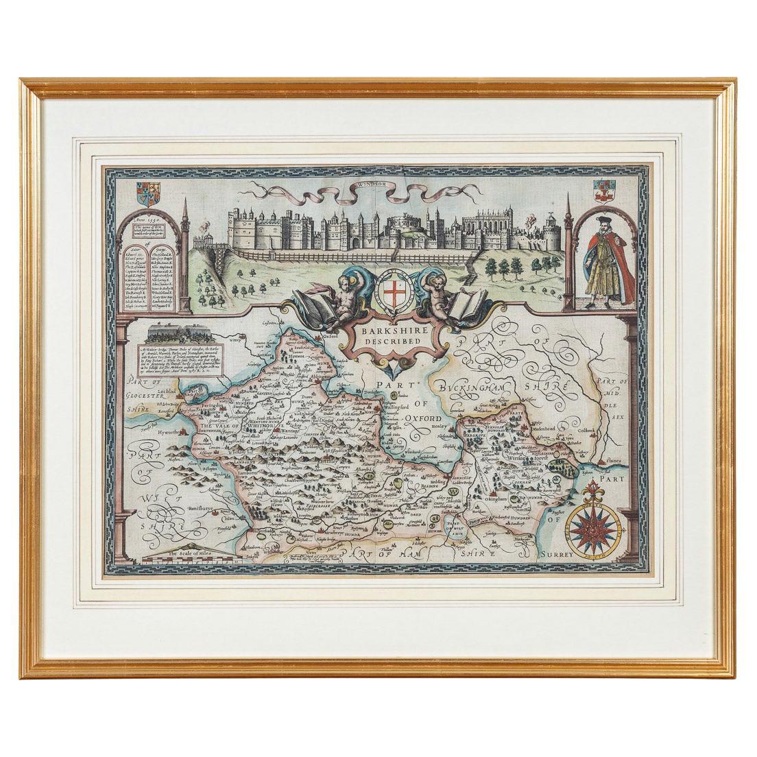
- 17th Century John Speed Map of the Barkshire Described, c.1616By John SpeedLocated in Royal Tunbridge Wells, KentAntique 17th century British very rare and original John Speed (1551-1629) map of the Barkshire Described, J. Sud and Georg Humble, publication (1616 or lat...Category
Antique 17th Century British Maps
MaterialsPaper
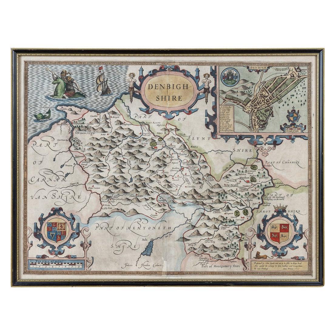
- 17th Century John Speed Map of Denbighshire, c.1610By John SpeedLocated in Royal Tunbridge Wells, KentAntique early 17th century British very rare and original John Speed, hand coloured map of Denbighshire, dated 1610, by John Sunbury and George Humble. John...Category
Antique 17th Century British Maps
MaterialsWood, Paper
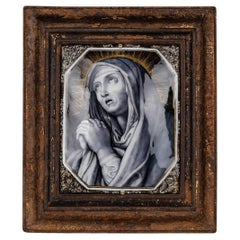
- Antique 17th Century Limoge Signed Plaque Of A Madonna PrayingLocated in Royal Tunbridge Wells, KentAntique 17th Century French painted porcelain wall hanging plaque portraying the Madonna in prayer against a radiant sunburst backdrop. Intricately painted with foliate patterns ador...Category
Antique 17th Century French Other Religious Items
MaterialsPorcelain
- 19th Century John Cary Map of North Part of West Riding of Yorkshire, C.1805By John CaryLocated in Royal Tunbridge Wells, KentAntique 19th century British original John Cary sr (1755-1835) map of North part of the West Riding of Yorkshire, From the beft Authorities. Engraved J Car...Category
Antique 19th Century British Maps
MaterialsPaper
- 19th Century John Cary Map of South Part of West Riding of Yorkshire, circa 1805By John CaryLocated in Royal Tunbridge Wells, KentAntique 19th century British original John Cary sr (1755-1835) map of South part of the West Riding of Yorkshire, From the beft Authorities. Engraved J Car...Category
Antique 19th Century British Maps
MaterialsPaper
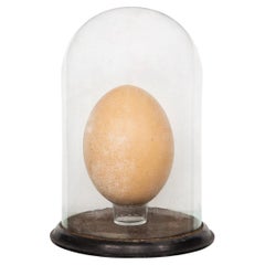
- Pre-17th Century Extremely Rare & Complete Elephant Bird Egg, MadagascarLocated in Royal Tunbridge Wells, KentAn extremely rare elephant bird egg, completely intact. The Elephant Bird, formally categorised as Aepyornis Maximus, is an enormous flightless bird ...Category
Antique Early 17th Century Malagasy Taxidermy
MaterialsEggshell


You May Also Like
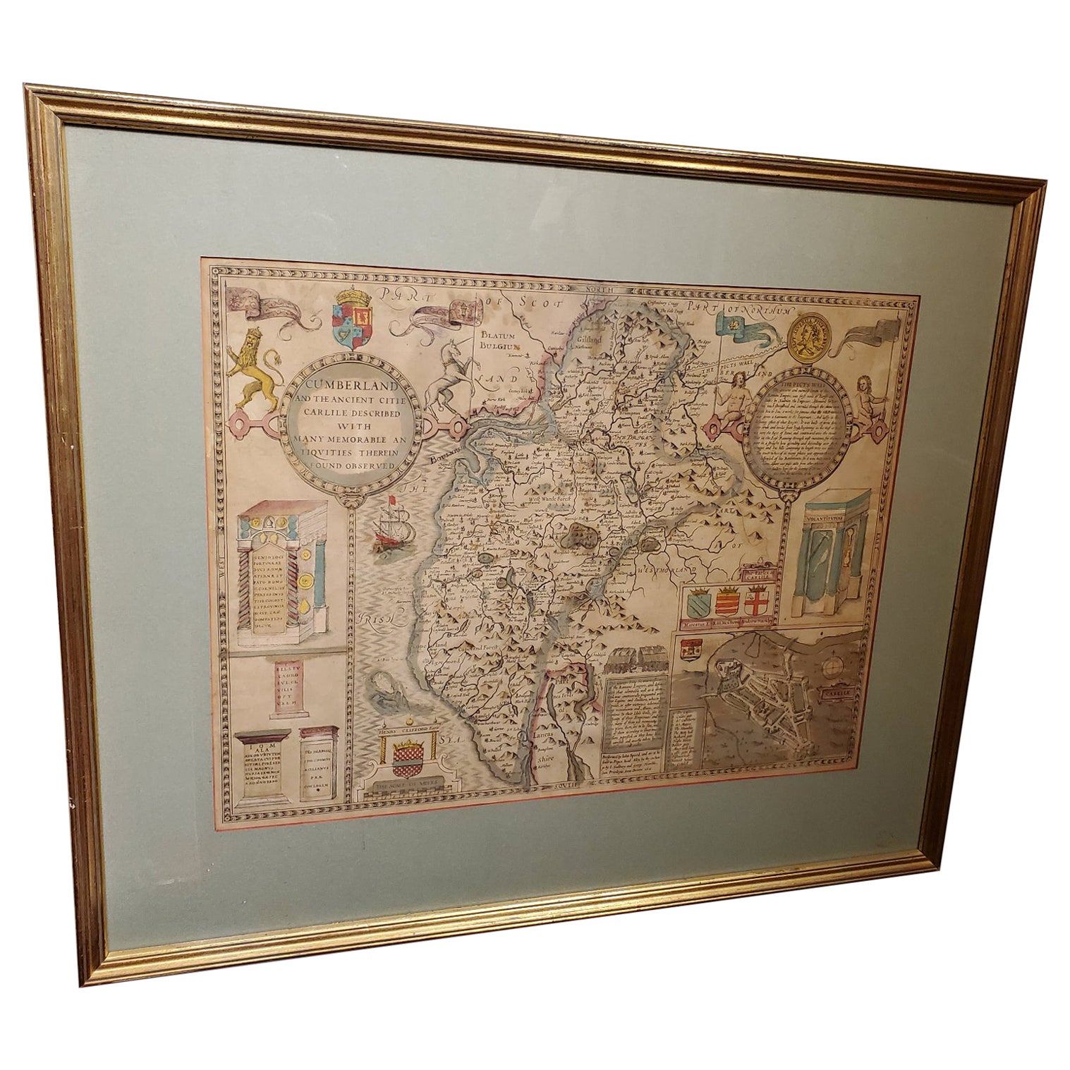
- 17th Century Map of Cumberland County in Northwest England Printed by John SpeedBy John SpeedLocated in Middleburg, VARare extremely early map of the county of Cumberland in the Northwest of England. Printed by John Speed, hand colored. Excellent condition. English. Dated...Category
Antique Early 17th Century English Maps
MaterialsPaper
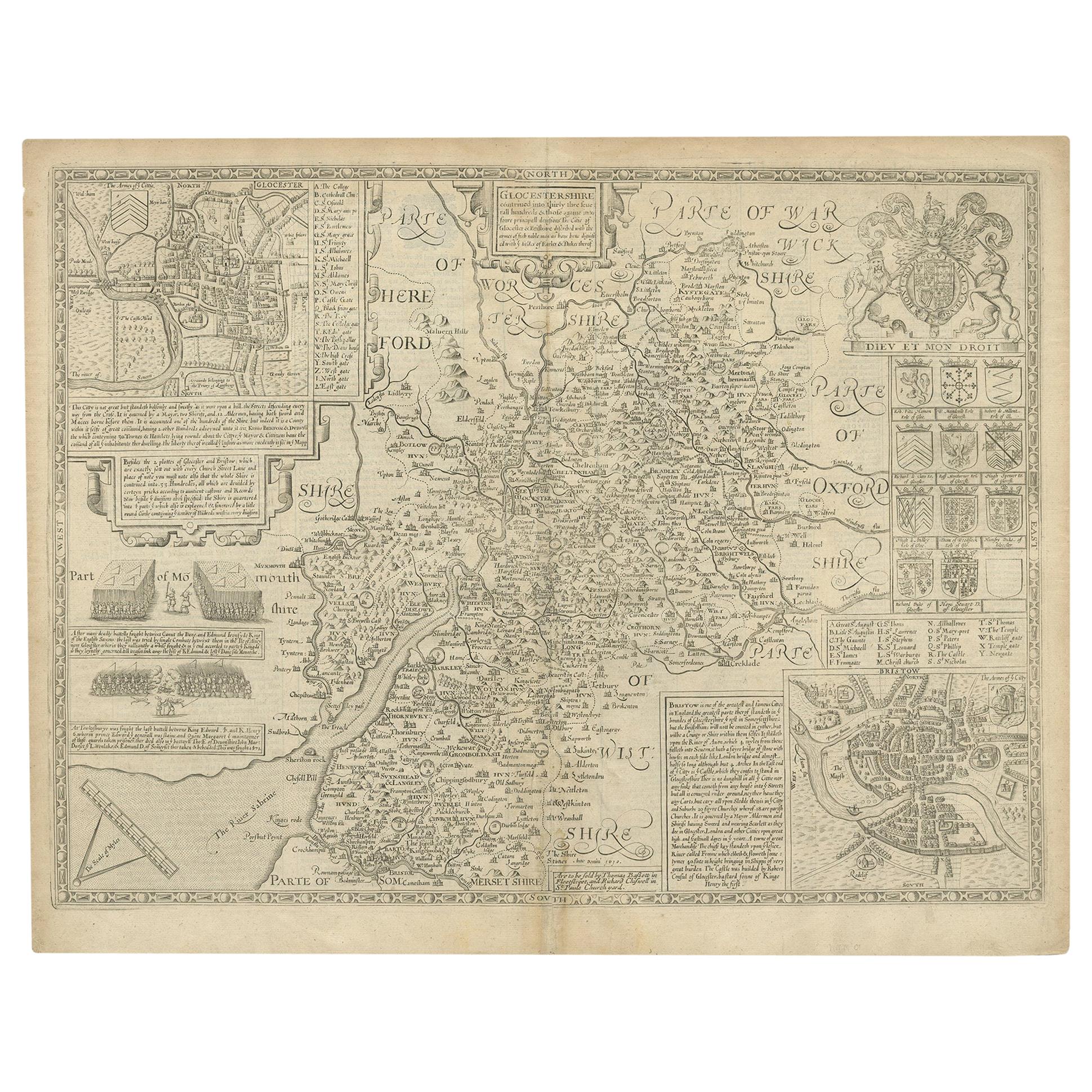
- Antique Map of Gloucestershire by John Speed, '1676'Located in Langweer, NLAntique map titled 'Glocestershire'. Original 17th century map of Gloucestershire, South West England, by John Speed. With inset town plans of G...Category
Antique Mid-17th Century Maps
MaterialsPaper
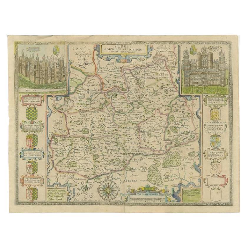
- Antique Map of Surrey by Speed, 1676Located in Langweer, NLAntique map titled 'Surrey described and divided into hundreds'. Map of Surrey, England. Includes inset elevations of Richmond and Nonsuch Palaces. This map originates from 'Theatre ...Category
Antique 17th Century Maps
MaterialsPaper
- Antique Map of Northamptonshire by Speed, 1676Located in Langweer, NLAntique map titled 'Norhamtonshire'. Map of Norhamptonshire, England. Includes inset town plans of Peterborough and Northampton. This map originates from 'Theatre of Great Britaine' ...Category
Antique 17th Century Maps
MaterialsPaper
- Antique Map of Nottinghamshire by Speed, 1676Located in Langweer, NLAntique map titled 'The Countie of Nottingham (..)'. Map of Nottinghamshire, England. Includes an inset town plan of Nottingham. This map originates from 'Theatre of Great Britaine' ...Category
Antique 17th Century Maps
MaterialsPaper
- Antique Map of Kent with Inset Plans of Rochester & Canterbury, England, 1676Located in Langweer, NLAntique map titled 'Kent with her Cities and Earles described and observed'. Map of Kent, England. Includes inset town plans of Rochester and Canterbury....Category
Antique 17th Century Maps
MaterialsPaper
Recently Viewed
View AllMore Ways To Browse
Antique 17th
Original City Map
Antique Kent
English Early 17th Century Furniture
Antique 17th Century Map
Antique English 17th Century
Antique Furniture Kent
Antique Furniture In Kent
Antique English Maps
English Glazed Gilt
17th C English
Maps United Kingdom
Thomas Earl
Map Of United Kingdom
John Speed
Thomas Kent
Used Bassett Furniture
Speed Map