Items Similar to 1879 "United States of America, Western Part" by O. J. Stuart


Video Loading
Want more images or videos?
Request additional images or videos from the seller
1 of 7
1879 "United States of America, Western Part" by O. J. Stuart
About the Item
This colorful original map, titled “United States of America, Western Part,” was issued in Volume 16 of “The American Cyclopædia.” A detailed reference map, the map was printed in color and engraved by O. J. Stuart in New York.
The map depicts the Western states of the United States at the time of printing, 1879. The states shown are Washington, Oregon, California, Montana, Idaho, Wyoming, Utah, Colorado, Arizona, New Mexico, Dakota, Nebraska, Kansas, Indian Territory, and Texas. The state borders are emphasized in red. The states are bordered by the Dominion of Canada to the north, Lower California and Mexico to the south, and Minnesota, Iowa, Missouri, and Kansas to the east. Many Native American tribes, forts, military reservations, and towns are depicted, as well as prominent rivers, mountains, lakes.
This map is a lovely snapshot of the Western states and territories during a time of exponential population growth. The passage of the Homestead Act and completion of the first transcontinental railroad meant that, by 1870, the possibility of western migration was opened to more Americans than ever before. Nearly 400,000 settlers made the trek westward during the height of the 1870s. Between 1867 and 1879, Congress also authorized and funded four significant surveys, in effort to learn more about the area west of the Mississippi River.
CONDITION:
Good condition. Colored map, with state borders in red. Titled "United States of America, Western Part" at bottom left in the Pacific Ocean. "Engd. by O. J. Stuart, N.Y." is printed at the bottom right. From “The American Cyclopædia,” v. 16, 1879, p. 126-7. Map dimensions: 12" H x 10" W.
Map is artfully framed with acid-free mats, an attractive linen top mat, UV Conservation clear glass, and a custom-built wooden frame. Framed Dimensions: 16 1/4 H x 14” W x 1 1/8” D.
- Dimensions:Height: 16.25 in (41.28 cm)Width: 14 in (35.56 cm)Depth: 1.13 in (2.88 cm)
- Materials and Techniques:
- Place of Origin:
- Period:
- Date of Manufacture:1879
- Condition:Additions or alterations made to the original: Archival framing by Rio Grande Custom Framing in Boulder, Colorado, in April of 2023. Wear consistent with age and use.
- Seller Location:Colorado Springs, CO
- Reference Number:
About the Seller
4.9
Platinum Seller
These expertly vetted sellers are 1stDibs' most experienced sellers and are rated highest by our customers.
Established in 2010
1stDibs seller since 2011
400 sales on 1stDibs
Typical response time: <1 hour
- ShippingRetrieving quote...Ships From: Colorado Springs, CO
- Return PolicyA return for this item may be initiated within 10 days of delivery.
More From This SellerView All
- 1859 "Map of the United States of America..." by J. H. ColtonBy J.H. ColtonLocated in Colorado Springs, COPresented is an 1859 “Map of the United States of America, the British Provinces, Mexico, the West Indies and Central America with Part of...Category
Antique 1850s American Maps
MaterialsPaper
- 1847 Ornamental Map of the United States & Mexico by H. PhelpsLocated in Colorado Springs, COOffered is an original 1847 ornamental map of the U.S. entitled "Ornamental Map of the United States & Mexico" by Humphrey Phelps. The map was issued as an act of Congress by Phelps on Fulton Street, New York. The broadside is elaborately hand-colored. This is a very detailed and graphic propaganda map of the United States expressing U.S. dominance of the North American continent. The hand-colored map proclaims the Manifest Destiny, with the recent acquisition of Upper California and Texas at the conclusion of the Mexican-American War. The newly acquired land is boldly colored, standing in stark contrast to the rest of the U.S. The map details a potential route for a railroad running from New York City, to Buffalo, to Chicago, then west along the Oregon Trail to Oregon City. This route anticipates the construction of the transcontinental railroad by nearly 20 years. The map includes elaborately detailed renderings of George Washington, Hernan Cortez, and Montezuma at top to represent European expansion to the Americas. At bottom are four inset designs with text showing the following: a chronological history of the U.S. beginning from settlement to the U.S. victory in the Mexican-American war; an illustration of General Zachary Taylor with details on the Oregon Territory; an illustration of the Aztec Temple of the Sun in Tenochtitlan and a chronology of the Conquest of the Aztec Empire under Cortez; a portrait of General Antonio Lopez de Santa Anna...Category
Antique 1840s American Maps
MaterialsPaper
- 1842 Wall Map of the United States by J. H. Young, Published by S. A. MitchellLocated in Colorado Springs, COPresented is an 1842 hanging “Map of the United States,” engraved by J. H. Young and published by Samuel Augustus Mitchell, Philadelphia. This is a beautiful example of the rare 1842...Category
Antique 1840s American Maps
MaterialsPaper
- 1866 Ensign & Bridgman's Rail Road Map of the United StatesLocated in Colorado Springs, COPresented is an 1866 issue of “Ensign & Bridgeman’s Rail Road Map of the United States, showing Depots & Stations.” First published in 1856, this is the third edition, following anot...Category
Antique 1860s American Late Victorian Maps
MaterialsPaper
- Navy Five-Star Admirals Signatures, United States World War IILocated in Colorado Springs, COThis amazing piece of U.S. Naval history features signed items from all four World War II Navy Admirals to ever wear the five-star rank. All are cons...Category
Mid-20th Century American Historical Memorabilia
MaterialsPaper
- 1812 United States Map, by Pierre Tardieu, Antique French Map Depicting the U.S.By Pierre François TardieuLocated in Colorado Springs, CO1812 "United States of Nth America -- Carte des Etats-Unis De L'Amerique Septentrionale" Two-Sheet Map by Tardieu This attractive map, published in Paris in 1812, is one of the most rare large format maps from the period. It features a view of the East Coast of the U.S. from Maryland to just below South Carolina. Additionally, Ellicott’s plan for the City of Washington D.C. is included at the top right and an illustration of Niagara Falls is shown at the bottom right with a description in both French and English. This extremely detailed map not only depicts the mountainous regions of the southeastern U.S., but also includes names of regions, rivers, and towns. Based on the first state of Arrowsmith’s 4-sheet map of the United States, this map is completely engraved by Tardieu in Paris and showcases high quality engravings. This detailed map of the recently independent United States includes one of the largest and earliest examples of the Ellicott plan of Washington DC. The artist, Pierre François Tardieu (PF Tardieu) was a very well-known map engraver, geographer, and illustrator. Awarded a bronze medal by King Louis-Phillipe for the accuracy and beauty of his map-making, Tardieu produced many fine works including maps of Louisiana...Category
Antique 1810s French Maps
MaterialsPaper


You May Also Like
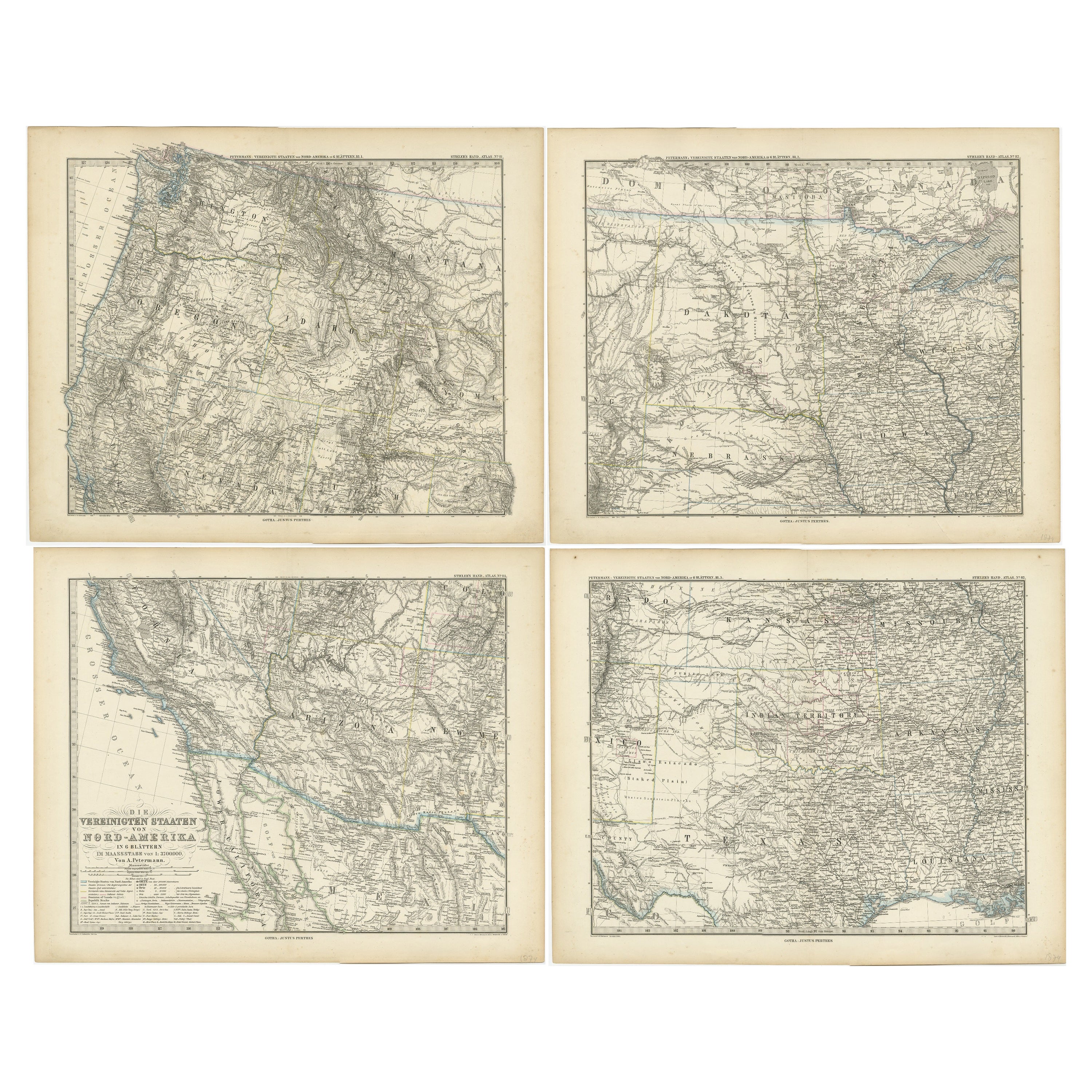
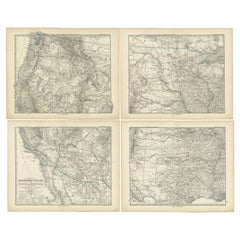
- Set of 4 Antique Maps of part of the United States of AmericaLocated in Langweer, NLSet of four individual antique maps of part of the United States. Published as part of a set of six individual maps. These maps originate from Stielers Handatlas, published circa 1...Category
Antique Mid-19th Century Maps
MaterialsPaper
- Antique Map Colton's United States of AmericaLocated in Langweer, NLAntique map titled 'Colton's United States of America'. Show railroads, canals, state capitals, major cities and towns, military posts, historic trails, Pony Express and U.S. mail routes; Dakota [Territory] extending deep into Nebraska, and Idaho [Territory] encompassing [modern day] Montana and Wyoming; Indian Territory...Category
Antique Mid-19th Century Maps
MaterialsPaper
- Antique Map of The United States of North America, Pacific States, 1882Located in Langweer, NLThe map is from the same 1882 Blackie Atlas and focuses on the Pacific States of the United States of America during that period. Here are some details and historical context about t...Category
Antique 1880s Maps
MaterialsPaper
- Antique Map of the United States of America by Lapie '1842'Located in Langweer, NLAntique map titled 'Carte des États-Unis d'Amérique'. Map of the United States of America (USA). This map originates from 'Atlas universel...Category
Antique Mid-19th Century Maps
MaterialsPaper
- Pair of Brass Studded Leather Tapaderos, Western United States, circa 1930Located in Ottawa, OntarioTapaderos (stirrup covers) were used by ranchers when herding cattle in the brush and open field. Made of stitched heavy gauge leather and decorated with applied brass studs, both r...Category
Early 20th Century American Country Sports Equipment and Memorabilia
MaterialsBrass
- Model of the American Merchant Ship “United States Victory”Located in Norwell, MAProfessionally built model of the American merchant ship “United States Victory”. The model has masts, booms, hatches, super structure, bitts, cleats, ri...Category
Vintage 1940s North American Models and Miniatures
MaterialsWood


Recently Viewed
View AllMore Ways To Browse
Western New York
Antique Survey
Antique Colorado
Stuart W
Used Furniture Missouri
Antique Furniture Colorado
Used Furniture In Missouri
Antique Furniture Stuart
Used Furniture Utah
Washington Map
Antique South Indian Furniture
South Indian Antique Furniture
Antique Ocean Prints
Wooden Printing
Texas Maps
Texas Map
Antique Utah
Antique Furniture Kansas