Items Similar to Antique French Map of Indre Region with Châteauroux and Issoudun, 1800s


Want more images or videos?
Request additional images or videos from the seller
1 of 10
Antique French Map of Indre Region with Châteauroux and Issoudun, 1800s
$165.56
£125.85
€140
CA$232.66
A$252.99
CHF 133.30
MX$3,073.07
NOK 1,675.85
SEK 1,570.97
DKK 1,071.59
About the Item
Antique Map of Indre, France by Vuillemin, 19th Century
This fine decorative map presents the département of Indre, situated in the Centre-Val de Loire region of central France. Engraved by Alexandre Vuillemin in the mid-19th century, it is part of his celebrated atlas of French départements, known for combining precise cartography with richly engraved illustrations.
The map delineates towns, rivers, and roads with departmental borders highlighted in original outline hand-coloring. At the upper left, a vignette shows the Château de Châteauroux, a significant landmark in the département. Surrounding engravings further embellish the composition: a military officer in uniform, the coat of arms of Indre, a beaver, and a view of the ruins of the Abbey of Déols. Together, these images emphasize the region’s military, historical, and natural character.
The département of Indre is historically important, with Châteauroux as its capital. Known for its rich landscapes and heritage sites, the area has long been associated with both agriculture and cultural landmarks.
Alexandre Vuillemin (1812–1880), a prominent French cartographer and publisher, was renowned for his clear geographical renderings enriched with decorative elements. His atlas of France’s départements remains a sought-after work, offering both a geographical overview and insight into the identity of each region during the 19th century.
Condition report: Very good condition with strong hand-coloring on borders. Light scattered foxing and faint toning in the margins, consistent with age. Decorative engravings remain crisp and well-preserved.
Framing tips: A dark wood or walnut frame with a wide ivory mat will emphasize the finely engraved vignettes. Adding a soft green inner liner can subtly highlight the Loire landscape theme.
Technique: Engraving with original hand color
Maker: Alexandre Vuillemin, France, mid-19th century
- Dimensions:Height: 12.8 in (32.5 cm)Width: 10.28 in (26.1 cm)Depth: 0.01 in (0.2 mm)
- Materials and Techniques:Paper,Engraved
- Place of Origin:
- Period:
- Date of Manufacture:circa 1850
- Condition:Condition report: Very good condition with strong hand-coloring on borders. Light scattered foxing and faint toning in the margins, consistent with age. Decorative engravings remain crisp and well-preserved.
- Seller Location:Langweer, NL
- Reference Number:Seller: BG-13331-351stDibs: LU3054346796802
About the Seller
5.0
Recognized Seller
These prestigious sellers are industry leaders and represent the highest echelon for item quality and design.
Platinum Seller
Premium sellers with a 4.7+ rating and 24-hour response times
Established in 2009
1stDibs seller since 2017
2,696 sales on 1stDibs
Typical response time: <1 hour
- ShippingRetrieving quote...Shipping from: Langweer, Netherlands
- Return Policy
Authenticity Guarantee
In the unlikely event there’s an issue with an item’s authenticity, contact us within 1 year for a full refund. DetailsMoney-Back Guarantee
If your item is not as described, is damaged in transit, or does not arrive, contact us within 7 days for a full refund. Details24-Hour Cancellation
You have a 24-hour grace period in which to reconsider your purchase, with no questions asked.Vetted Professional Sellers
Our world-class sellers must adhere to strict standards for service and quality, maintaining the integrity of our listings.Price-Match Guarantee
If you find that a seller listed the same item for a lower price elsewhere, we’ll match it.Trusted Global Delivery
Our best-in-class carrier network provides specialized shipping options worldwide, including custom delivery.More From This Seller
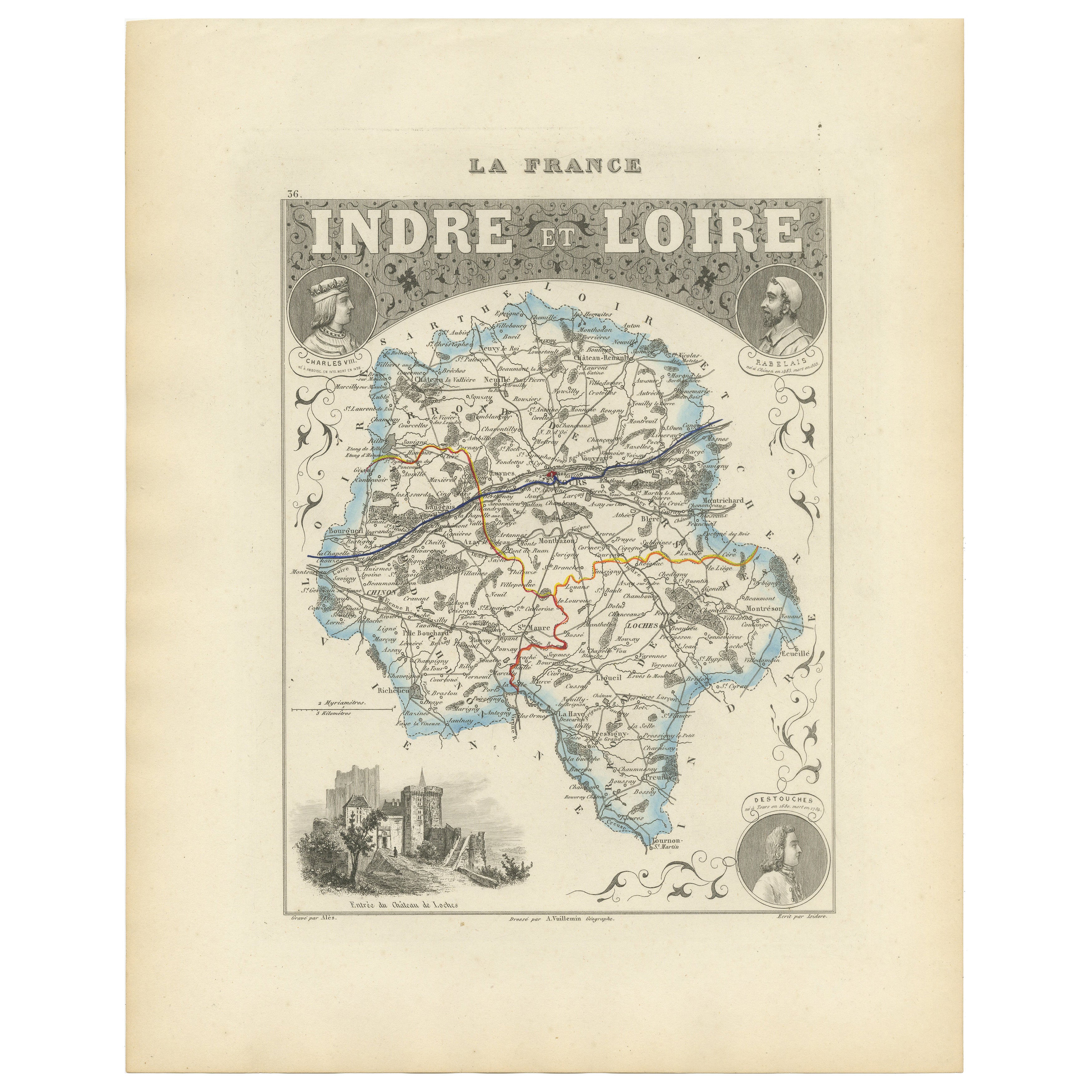
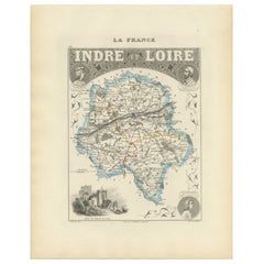
View AllAntique French Map of Indre-et-Loire with Tours, Amboise, Chinon, 1800s
Located in Langweer, NL
Antique Map of Indre-et-Loire, France by Vuillemin, 19th Century
This beautifully engraved map illustrates the département of Indre-et-Loire, located in the Centre-Val de Loire regi...
Category
Antique Mid-19th Century French Maps
Materials
Paper
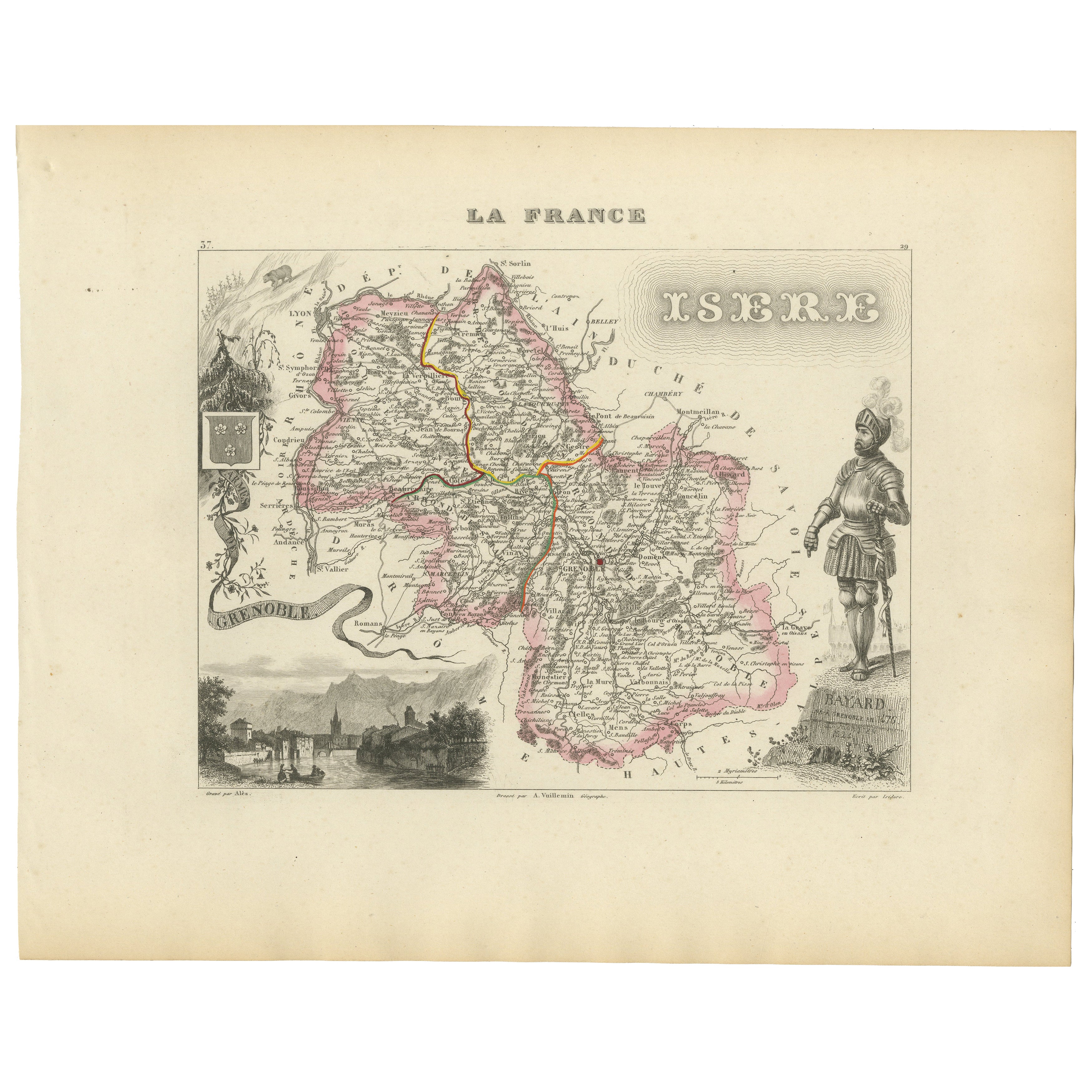
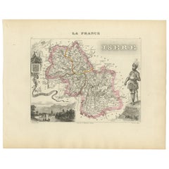
Antique French Map of Isère Region with Grenoble, Vienne, Dauphiné, 1800s
Located in Langweer, NL
Antique Map of Isère, France by Vuillemin, 19th Century
This decorative 19th-century map presents the département of Isère in southeastern France, engraved by Alexandre Vuillemin. C...
Category
Antique Mid-19th Century French Maps
Materials
Paper
Antique French Map of Ille-et-Vilaine Region with Rennes, Saint-Malo, 1800s
Located in Langweer, NL
Antique Map of Ille-et-Vilaine, France by Vuillemin, 19th Century
This decorative antique map presents the French département of Ille-et-Vilaine, situated in the Brittany region of ...
Category
Antique Mid-19th Century French Maps
Materials
Paper

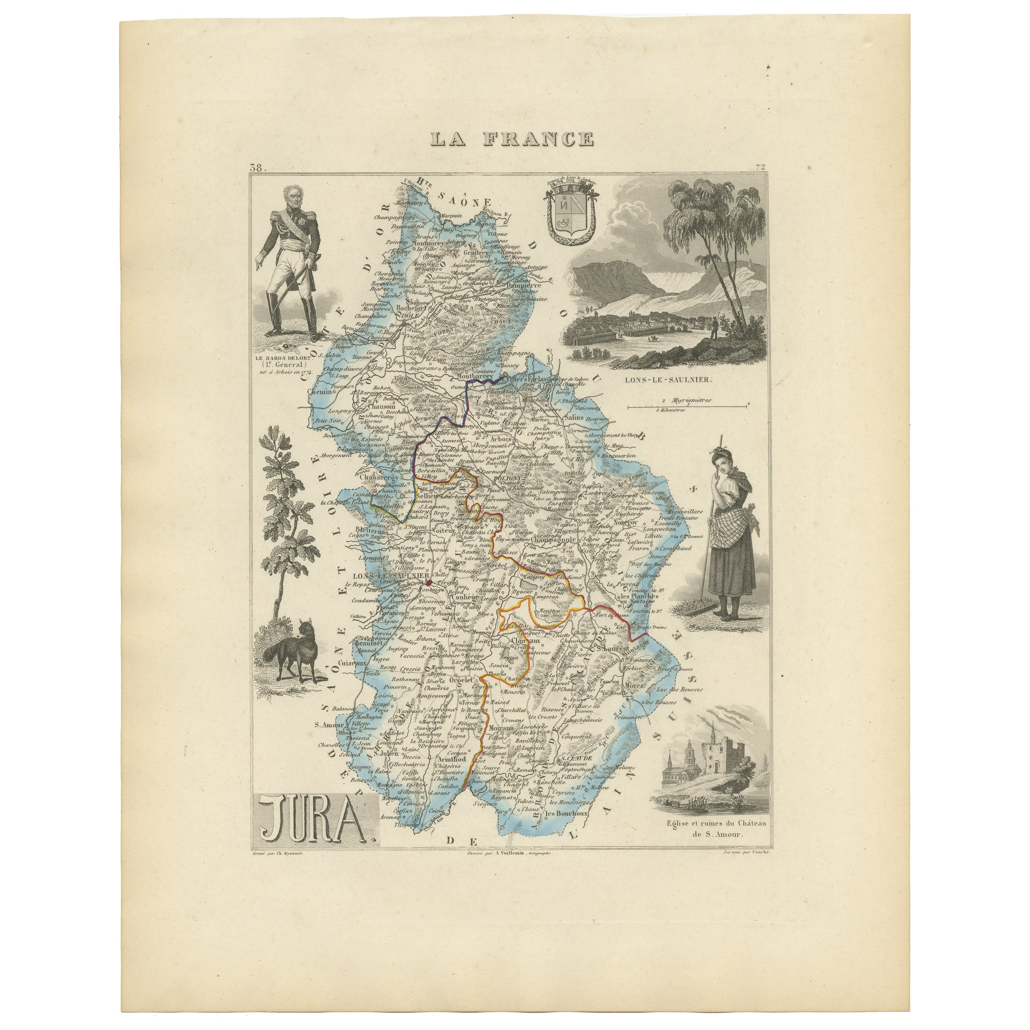
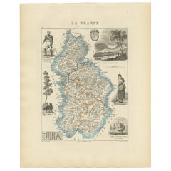
Antique French Map of Jura Region with Lons-le-Saunier, Dole, 1800s
Located in Langweer, NL
Antique Map of Jura, France by Vuillemin, 19th Century
This decorative 19th-century engraved map shows the département of Jura in eastern France, produced by Alexandre Vuillemin. Th...
Category
Antique Mid-19th Century French Maps
Materials
Paper
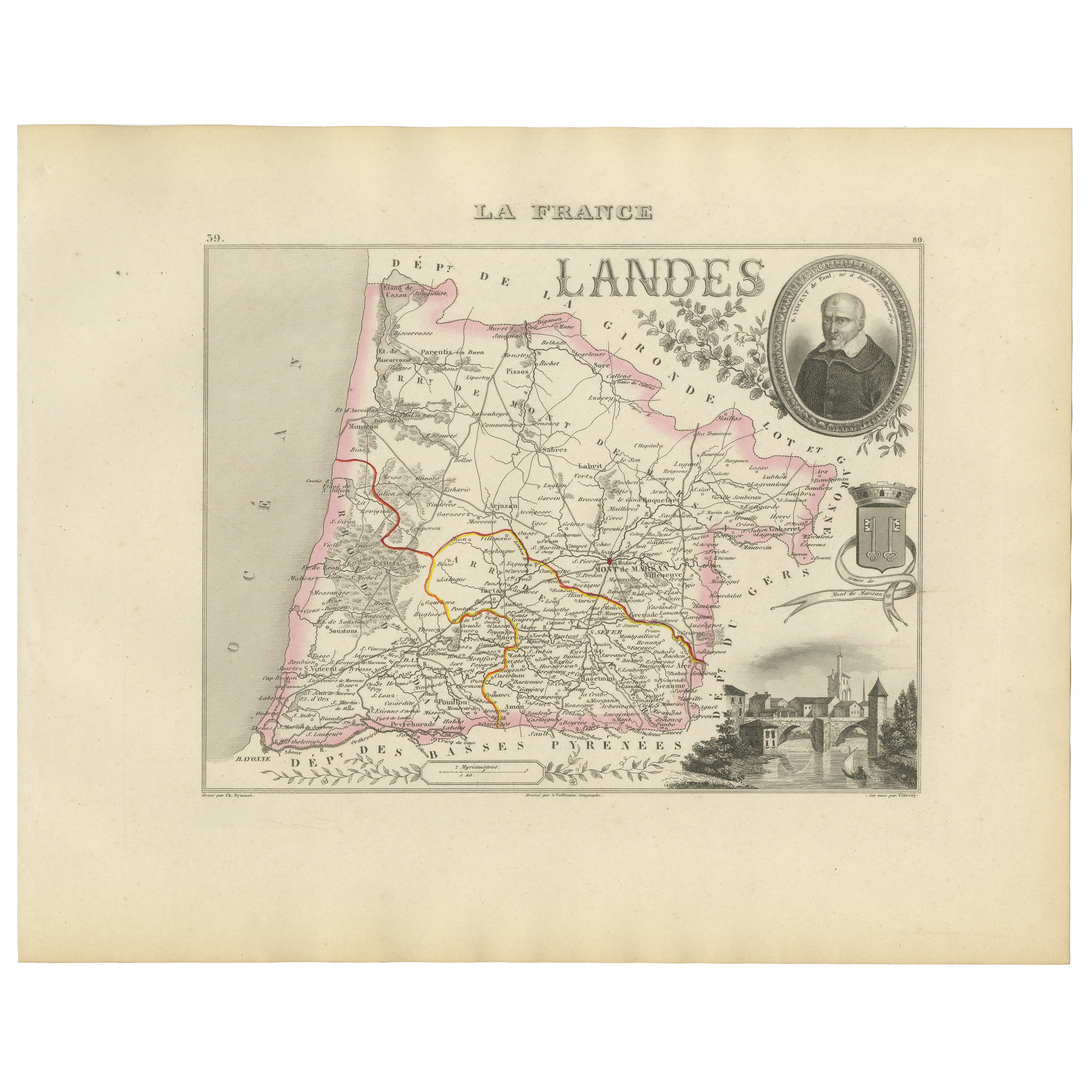
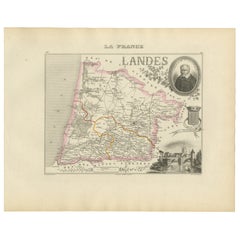
Antique French Map of Landes Region with Mont-de-Marsan, Dax, Bayonne, 1800s
Located in Langweer, NL
Antique Map of Landes, France by Vuillemin, 19th Century
This fine 19th-century engraved map depicts the département of Landes in southwestern France, engraved by Alexandre Vuillemi...
Category
Antique Mid-19th Century French Maps
Materials
Paper
Map of Côtes-du-Nord France with Saint-Brieuc and Brittany Coastline, c.1850
Located in Langweer, NL
Map of Côtes-du-Nord France with Saint-Brieuc and Brittany Coastline, 19th c
Description:
This elegant 19th-century map of Côtes-du-Nord, the historic name for what is now known as ...
Category
Antique Mid-19th Century French Maps
Materials
Paper

You May Also Like
L'Isere, France. Antique map of French department, 1856
By Victor Levasseur
Located in Melbourne, Victoria
'Dept. de L'Isere', Steel engraving with original outline hand-colouring., 1856, from Levasseur's 'Atlas National Illustre'.
This area is known for its production of Bleu du Vercor...
Category
19th Century Naturalistic Landscape Prints
Materials
Engraving

Aube, France. Antique map of a French department, 1856
By Victor Levasseur
Located in Melbourne, Victoria
'Dept. de L'Aube', steel engraving with original outline hand-colouring., 1856, from Levasseur's 'Atlas National Illustre'.
This area of France is known for its production of Chaou...
Category
19th Century Naturalistic Landscape Prints
Materials
Engraving

Aude, France. Antique map of a French department, 1856
By Victor Levasseur
Located in Melbourne, Victoria
'Dept. de L' Aude', steel engraving with original outline hand-colouring., 1856, from Levasseur's 'Atlas National Illustre'.
This area of France is famous for its wide variety of v...
Category
19th Century Naturalistic Landscape Prints
Materials
Engraving

Saone and Loire, France. Antique map of a French department, 1856
By Victor Levasseur
Located in Melbourne, Victoria
'Dept. de Saone et Loire', steel engraving with original outline hand-colouring., 1856, from Levasseur's Atlas National Illustre.
The French department of Saone et Loire is at the ...
Category
19th Century Naturalistic Landscape Prints
Materials
Engraving

1771 Bonne Map of Poitou, Touraine and Anjou, France, Ric.a015
Located in Norton, MA
1771 Bonne Map of Poitou,
Touraine and Anjou, France
Ric.a015
1771 Bonne map of Potiou, Touraine and Anjou entitled "Carte des Gouvernements D'Anjou et du Saumurois, de la Touraine, du Poitou,du Pays d'aunis, Saintonge?Angoumois,"
Carte des gouvernements d'Anjou et du Saumurois, de la Touraine, du Poitou, du Pays d'Aunis, Saintonge-Angoumois. Projettee et assujettie au ciel par M. Bonne, Hyd. du Roi. A Paris, Chez Lattre, rue St. Jacques a la Ville de Bord(ea)ux. Avec priv. du Roi. 1771. Arrivet inv. & sculp., Atlas moderne ou collection de cartes sur toutes...
Category
Antique 17th Century Unknown Maps
Materials
Paper

Indre and Loire, France. Antique map of a French department, 1856
By Victor Levasseur
Located in Melbourne, Victoria
'Dept. d'Indre et Loire', steel engraving with original outline hand-colouring., 1856, from Levasseur's 'Atlas National Illustre'.
This area is known for its production of Chenin b...
Category
19th Century Naturalistic Landscape Prints
Materials
Engraving
