Items Similar to Antique Map of Africa with Ocean Currents and Other Details, C.1780


Want more images or videos?
Request additional images or videos from the seller
1 of 6
Antique Map of Africa with Ocean Currents and Other Details, C.1780
About the Item
Antique map titled 'Afrique.' Detailed map of Africa, showing towns, rivers, some topographical features, ocean currents, ports and political boundaries. Source unknown, to be determined.
Artists and Engravers: Rigobert Bonne (1727-1795 ) was one of the most important cartographers of the late 18th century. In 1773 he succeeded Jacques Bellin as Royal Cartographer to France in the office of the Hydrographer at the Depôt de la Marine. Working in his official capacity Bonne compiled some of the most detailed and accurate maps of the period. Bonne's work represents an important step in the evolution of the cartographic ideology away from the decorative work of the 17th and early 18th century towards a more detail oriented and practical aesthetic. With regard to the rendering of terrain Bonne maps bear many stylistic similarities to those of his predecessor, Bellin. However, Bonne maps generally abandon such common 18th century decorative features such as hand coloring, elaborate decorative cartouches, and compass roses. While mostly focusing on coastal regions, the work of Bonne is highly regarded for its detail, historical importance, and overall aesthetic appeal.
Condition: Good, given age. Slight discolouriation near middle fold. Arabia with outline hand colouring. Right edge with tiny tear. Original middle fold as issued. General age-related toning and/or occasional minor defects from handling. Please study image carefully.
Date: c.1780
Overall size: 38.5 x 26 cm.
Image size: 31.8 x 22 cm.
We sell original antique maps to collectors, historians, educators and interior decorators all over the world. Our collection includes a wide range of authentic antique maps from the 16th to the 20th centuries. Buying and collecting antique maps is a tradition that goes back hundreds of years. Antique maps have proved a richly rewarding investment over the past decade, thanks to a growing appreciation of their unique historical appeal. Today the decorative qualities of antique maps are widely recognized by interior designers who appreciate their beauty and design flexibility. Depending on the individual map, presentation, and context, a rare or antique map can be modern, traditional, abstract, figurative, serious or whimsical. We offer a wide range of authentic antique maps for any budget.
- Dimensions:Height: 10.24 in (26 cm)Width: 15.16 in (38.5 cm)Depth: 0 in (0.01 mm)
- Materials and Techniques:
- Period:
- Date of Manufacture:circa 1780
- Condition:
- Seller Location:Langweer, NL
- Reference Number:
About the Seller
5.0
Platinum Seller
These expertly vetted sellers are 1stDibs' most experienced sellers and are rated highest by our customers.
Established in 2009
1stDibs seller since 2017
1,913 sales on 1stDibs
Typical response time: <1 hour
- ShippingRetrieving quote...Ships From: Langweer, Netherlands
- Return PolicyA return for this item may be initiated within 14 days of delivery.
More From This SellerView All
- Antique Map of West Africa by R. Bonne, 1780Located in Langweer, NLAntique map titled 'Partie Occidentale De L'Ancien Continent Depuis Lisbonne Jusqua La Riviere De Sierra Leona Avec L'Isle de Madere, les Isles Canaries et celles Du Cap Verd'. Parts...Category
Antique Late 18th Century Maps
MaterialsPaper
- Antique Map Showing the Ocean Currents and Temperature of Air, '1872'Located in Langweer, NLTwo maps on one sheet titled 'Johnson's Oceans Currents (..)' and 'Johnson's World showing the Distribution of the Temperature of the Air'. Original world map...Category
Antique Late 19th Century Maps
MaterialsPaper
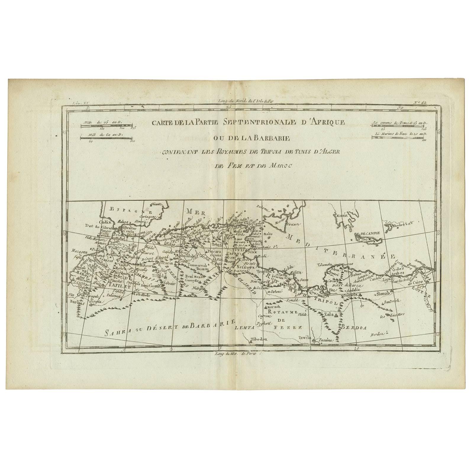
- Antique Map of Northern Africa "Barbary Coast" by R. Bonne, circa 1780Located in Langweer, NLA fine example of Rigobert Bonne and Guilleme Raynal’s 1780 map of northwestern Africa or the Barbary Coast. Includes the modern day countries of Morocco, Algeria, Tunisia, Libya, and parts of adjacent Spain, Italy and Greece. This map was made in response to European interest in the region due to coastal attacks and incursions by the Barbary Pirates...Category
Antique Late 18th Century Maps
MaterialsPaper
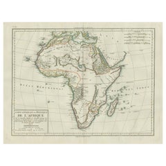
- Antique Map of Africa with Mountain Ranges and other detailsLocated in Langweer, NLAntique map titled 'Carte générale et Politique de l'Afrique'. Original antique map of Africa. Highlights numerous mountain ranges, lakes and rivers, regions, countries and places. P...Category
Antique Late 18th Century Maps
MaterialsPaper
- Antique Map of Sumatra, Indonesia 'c.1780'Located in Langweer, NLAntique map titled 'Neue Karte von der Insel Sumatra'. Extremely rare map of Sumatra, Indonesia. Published circa 1780.Category
Antique Late 18th Century Maps
MaterialsPaper
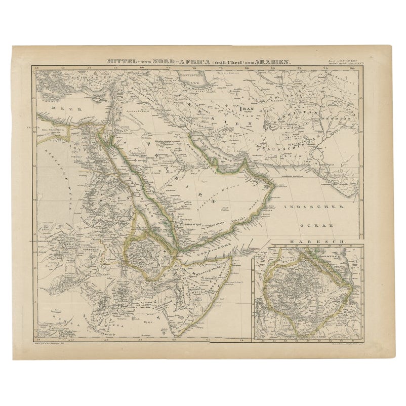
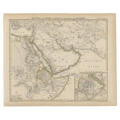
- Antique Map of Africa and Arabia with Inset Map of Ethiopia and Eritrea, 1845Located in Langweer, NLAntique map titled 'Mittel- und Nord-Africa (östl. Theil) und Arabien'. This map depicts North and Central Africa and Arabia with an inset map of Habesch (Ethiopia and Eritrea). Ar...Category
Antique 19th Century Maps
MaterialsPaper


You May Also Like
- Original Antique Map of Italy. C.1780Located in St Annes, LancashireGreat map of Italy Copper-plate engraving Published C.1780 Unframed.Category
Antique Early 1800s English Georgian Maps
MaterialsPaper

- Original Antique Map of Asia. C.1780Located in St Annes, LancashireGreat map of Asia Copper-plate engraving Published C.1780 Two small worm holes to right side of map Unframed.Category
Antique Early 1800s English Georgian Maps
MaterialsPaper

- Original Antique Map of India. C.1780Located in St Annes, LancashireGreat map of India Copper-plate engraving Published C.1780 Three small worm holes to right side of map and one bottom left corner Unframed.Category
Antique Early 1800s English Georgian Maps
MaterialsPaper

- Original Antique Map of South America. C.1780Located in St Annes, LancashireGreat map of South America Copper-plate engraving Published C.1780 Two small worm holes to left side of map Unframed.Category
Antique Early 1800s English Georgian Maps
MaterialsPaper
- Original Antique Map of South Africa, Arrowsmith, 1820Located in St Annes, LancashireGreat map of South Africa. Drawn under the direction of Arrowsmith. Copper-plate engraving. Published by Longman, Hurst, Rees, Orme and Br...Category
Antique 1820s English Maps
MaterialsPaper
- Antique Map of Principality of MonacoBy Antonio Vallardi EditoreLocated in Alessandria, PiemonteST/619 - "Old Geographical Atlas of Italy - Topographic map of ex-Principality of Monaco" - ediz Vallardi - Milano - A somewhat special edition ---Category
Antique Late 19th Century Italian Other Prints
MaterialsPaper


Recently Viewed
View AllMore Ways To Browse
Antique Step Backs
20th Century Africa Collectibles
Antique Collectible Bears
Unknown Circa 1780
18th Century African
Topographical Map
Ocean Maps
Ocean Map
Marine Collectibles
Marine 18th Century
Compass Map
Antique Maps Africa
Antique Map Africa
Antique Africa Map
Antique African Map
Africa Antique Map
Africa Map Antique
Antique Africa Maps