Items Similar to Antique Map of The Asian Continent, 1855

Want more images or videos?
Request additional images or videos from the seller
1 of 5
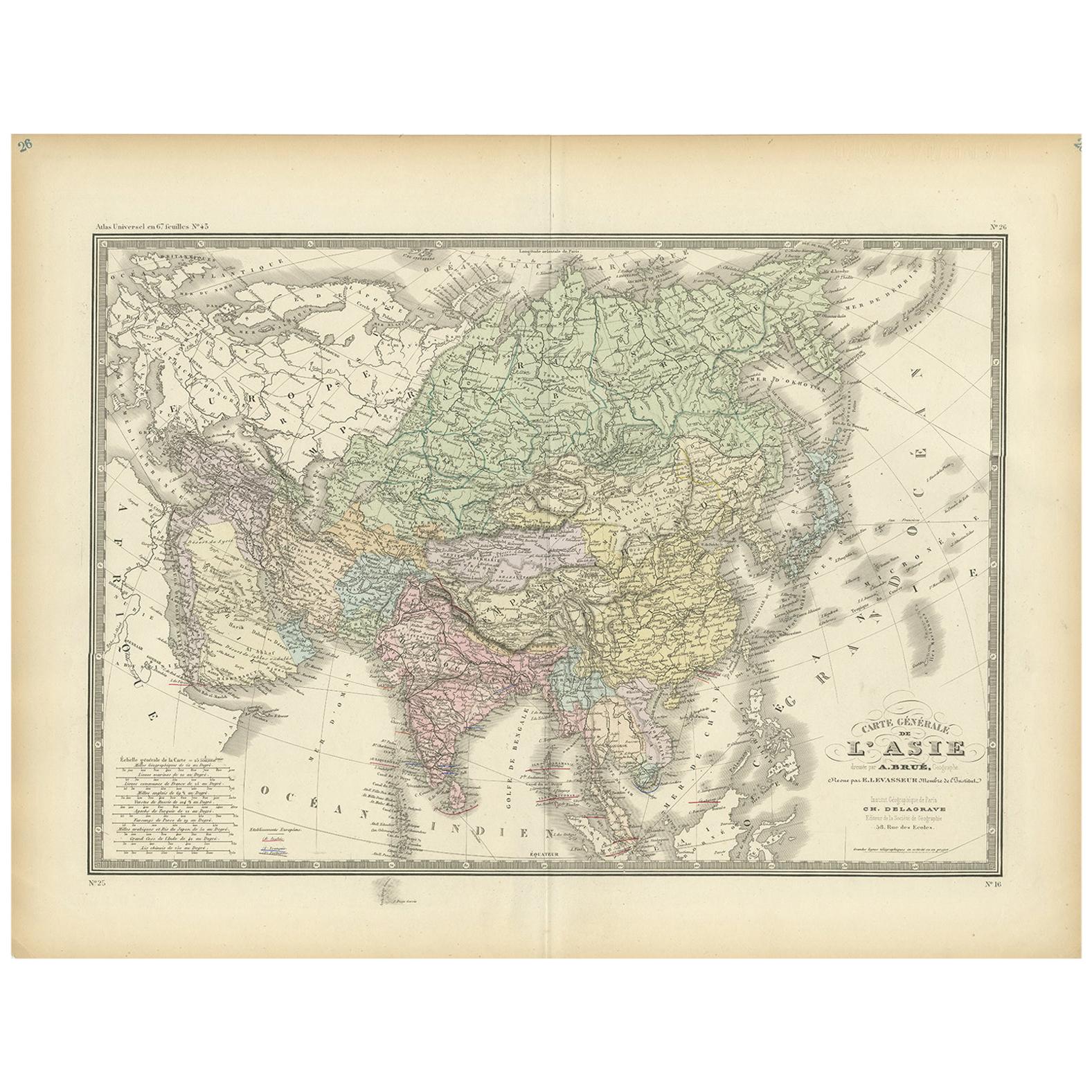
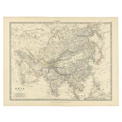
Antique Map of The Asian Continent, 1855
About the Item
Antique map titled 'Carte Générale de l 'Asie'. Beautiful map of the Asian continent. This map originates from 'Voyage en Asie et en Afrique, d'aprés les récits des derniers voyageurs' by Jean-Baptiste Eyries & Alfred Jacob.
Artists and Engravers: Engraved by Dufour.
Condition: Very good, please study image carefully.
Date: 1855
Overall size: 53 x 40 cm.
Image size: 49 x 32 cm.
We sell original antique maps to collectors, historians, educators and interior decorators all over the world. Our collection includes a wide range of authentic antique maps from the 16th to the 20th centuries. Buying and collecting antique maps is a tradition that goes back hundreds of years. Antique maps have proved a richly rewarding investment over the past decade, thanks to a growing appreciation of their unique historical appeal. Today the decorative qualities of antique maps are widely recognized by interior designers who appreciate their beauty and design flexibility. Depending on the individual map, presentation, and context, a rare or antique map can be modern, traditional, abstract, figurative, serious or whimsical. We offer a wide range of authentic antique maps for any budget.
- Dimensions:Height: 15.75 in (40 cm)Width: 20.87 in (53 cm)Depth: 0 in (0.01 mm)
- Materials and Techniques:
- Period:
- Date of Manufacture:1855
- Condition:
- Seller Location:Langweer, NL
- Reference Number:
About the Seller
5.0
Platinum Seller
These expertly vetted sellers are 1stDibs' most experienced sellers and are rated highest by our customers.
Established in 2009
1stDibs seller since 2017
1,914 sales on 1stDibs
Typical response time: <1 hour
- ShippingRetrieving quote...Ships From: Langweer, Netherlands
- Return PolicyA return for this item may be initiated within 14 days of delivery.
More From This SellerView All
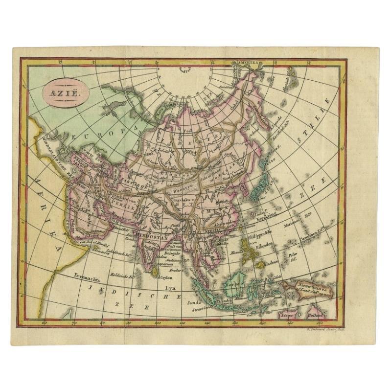
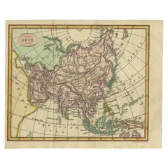
- Small Antique Map of the Asian Continent, 1841Located in Langweer, NLAntique map titled 'Azie.' Small map of the Asian continent. This map originates from 'De Aarde, beschouwd in haren Natuurlijken Toestand en Verdeeling (..)' by N.G. van Kampen. Publ...Category
Antique 19th Century Maps
MaterialsPaper
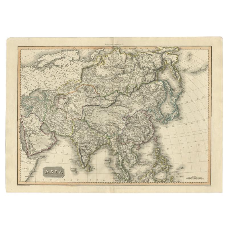
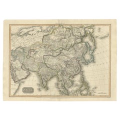
- Large Antique Map of the Asian Continent, 1814Located in Langweer, NLAntique map titled 'Asia'. Large antique map of the Asian continent. Drawn under the direction of Mr. Pinkerton by L. Hebert. Artists and Engraver...Category
Antique 19th Century Maps
MaterialsPaper
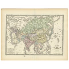
- Antique Map of the Asian Continent by Levasseur, '1875'Located in Langweer, NLAntique map titled 'Carte générale de l'Asie'. Large map of the Asian Continent. This map originates from 'Atlas de Géographie Moderne Physique et Politique' by A. Levasseur. Publish...Category
Antique Late 19th Century Maps
MaterialsPaper
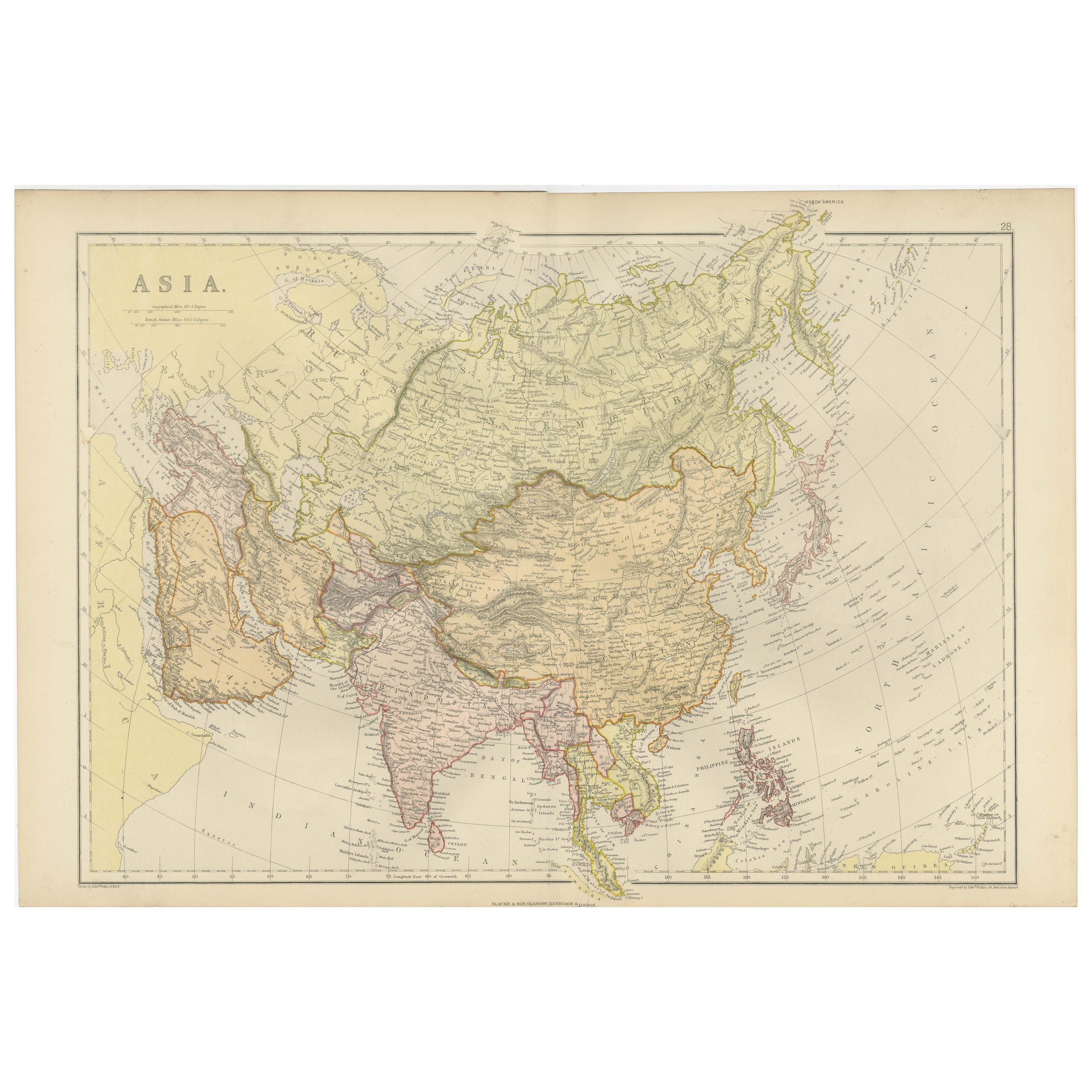
- Antique Map of the Asian Continent by Johnston, 1885Located in Langweer, NLAntique map titled 'Asia'. Beautiful map of the Asian continent by Keith Johnston F.R.S.E. Artists and Engravers: Engraved, printed and published by A.K. Johnston. Condition: ...Category
Antique 19th Century Maps
MaterialsPaper
- Historical Map Depicting the Continent of Asia, 1882Located in Langweer, NLThis 1882 map presents a meticulously detailed representation of the continent of Asia, a testament to the cartographic skills of the era. Published as a part of 'Comprehensive Atlas...Category
Antique 1880s Maps
MaterialsPaper
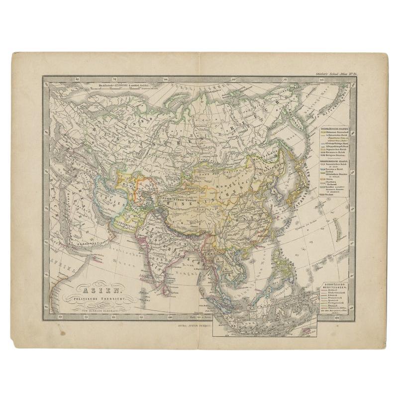
- Antique Map of the Asian Continent from a German School Atlas, 1862Located in Langweer, NLAntique map titled 'Asien Politische Ubersicht'. Old map of the Asian continent. Originates from Stieler's 'Schul-Atlas'. Artists and Engravers: Published by Johan Georg Justus Per...Category
Antique 19th Century Maps
MaterialsPaper
You May Also Like
- Original Antique Map of South East Asia, Arrowsmith, 1820Located in St Annes, LancashireGreat map of South East Asia Drawn under the direction of Arrowsmith Copper-plate engraving Published by Longman, Hurst, Rees, Orme and Brown, 1820 Unframed.Category
Antique 1820s English Maps
MaterialsPaper
- Africa: the Fashion ContinentBy Rizzoli International PublicationsLocated in New York, NYGain new perspective on the vibrant and innovative world of contemporary African fashion design, bursting with fresh creativity and free from reductive stereotypes. From the runway in Lagos and music festivals in Casablanca or Nairobi, to the “image makers” of Marrakech and the influencers of Dakar or Accra, a new generation of African fashion designers, photographers, bloggers, and hair and makeup artists are redefining the aesthetic contours of the continent. Audacious, humorous, disruptive, and innovative are the bywords of these young creatives who, while drawing upon and revalorizing their heritage, offer an ultra-contemporary perspective on fashion today. A creative revolution is spreading in an extension of continental revindication through cultural reappropriation and the invention of a visual language. Appliqué figures straight from Ghanaian Asafo flags seem to chant modern slogans as they march across silk dresses, traditional textile prints give power back to women, and Xhosa beaded embroidery serves as an inspiration for modern knitwear. Body-artists transform themselves into platforms for activism, and photographers—using clothing...Category
21st Century and Contemporary Books
MaterialsPaper
- Large Original Antique Map of Asia by Sidney Hall, 1847Located in St Annes, LancashireGreat map of Asia Drawn and engraved by Sidney Hall Steel engraving Original colour outline Published by A & C Black. 1847 Unframed Free shippingCategory
Antique 1840s Scottish Maps
MaterialsPaper
- Antique French Map of Asia Including China Indoneseia India, 1783Located in Amsterdam, Noord HollandVery nice map of Asia. 1783 Dedie au Roy. Additional information: Country of Manufacturing: Europe Period: 18th century Qing (1661 - 1912) Condition: Overall Condition B (Good Used)...Category
Antique 18th Century European Maps
MaterialsPaper
- Antique 1803 Italian Map of Asia Including China Indoneseia IndiaLocated in Amsterdam, Noord HollandAntique 1803 Italian Map of Asia Including China Indoneseia India Very nice map of Asia. 1803. Additional information: Type: Map Country of Manufacturing: Europe Period: 19th centu...Category
Antique 19th Century European Maps
MaterialsPaper
- Antique Carte de L'Inde Myanmar, Malaysia Vietnam Map of Asia the Chinese EmpireLocated in Amsterdam, Noord HollandAntique Carte de L'Inde Myanmar, Malaysia Vietnam Map of Asia the Chinese Empire Very nice map of Asia. Additional information: Type: Map Country of Man...Category
Antique 18th Century European Maps
MaterialsPaper