Items Similar to Antique Map of Borneo, Sumatra and Java 'Indonesia, Asia' by I. Tirion


Want more images or videos?
Request additional images or videos from the seller
1 of 5
Antique Map of Borneo, Sumatra and Java 'Indonesia, Asia' by I. Tirion
About the Item
Detailed map, with beautiful hand-coloring, of Southeast Asia, extending from the tip of Cambodia to Java, centered on Singapore and the Straits of Malacca. This map originates from 'Atlante novissimo che contiene tutte le parti del mondo' by G. Albrizzi.
- Creator:Isaak Tirion (Artist)
- Dimensions:Height: 11.5 in (29.2 cm)Width: 16.07 in (40.8 cm)Depth: 0.02 in (0.5 mm)
- Materials and Techniques:
- Period:
- Date of Manufacture:circa 1750
- Condition:Please study image carefully.
- Seller Location:Langweer, NL
- Reference Number:Seller: BG-003021stDibs: LU305438910863
About the Seller
5.0
Platinum Seller
These expertly vetted sellers are 1stDibs' most experienced sellers and are rated highest by our customers.
Established in 2009
1stDibs seller since 2017
1,916 sales on 1stDibs
Typical response time: <1 hour
- ShippingRetrieving quote...Ships From: Langweer, Netherlands
- Return PolicyA return for this item may be initiated within 14 days of delivery.
More From This SellerView All
- Antique Map of Singapore, Malaysia, Borneo, Sumatra and Java (Indonesia), 1739Located in Langweer, NL"Antique map titled 'Nieuwe kaart van de Sundasche Eilanden als Borneo, Sumatra en Groot Iava & c'. Detailed map of Southeast Asia, extending from the tip of Cambodia to Java. This m...Category
Antique 18th Century Maps
MaterialsPaper
- Antique Map of the Sunda Islands Sumatra, Java, Malay Peninsula & Borneo (1739)By Isaak TirionLocated in Langweer, NLAntique map titled 'Nieuwe kaart van de Sundasche Eilanden als Borneo, Sumatra en Groot Iava & c'. Detailed map of the Sunda Islands, Southeast Asia, extending from the tip of Cambod...Category
Antique Mid-18th Century Maps
MaterialsPaper
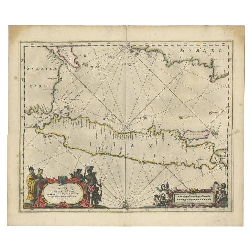
- Antique Map of Java and Part of Borneo, Indonesia, c.1657Located in Langweer, NLAntique map titled 'Insulae Iavae cum parte insularum Boreno Sumatrae (..)'. Beautiful map of the island of Java and part of Borneo, Bali, Madura and Sumatra. With decorative carto...Category
Antique 17th Century Maps
MaterialsPaper
- Antique Map of Sumatra, Indonesia 'c.1780'Located in Langweer, NLAntique map titled 'Neue Karte von der Insel Sumatra'. Extremely rare map of Sumatra, Indonesia. Published circa 1780.Category
Antique Late 18th Century Maps
MaterialsPaper
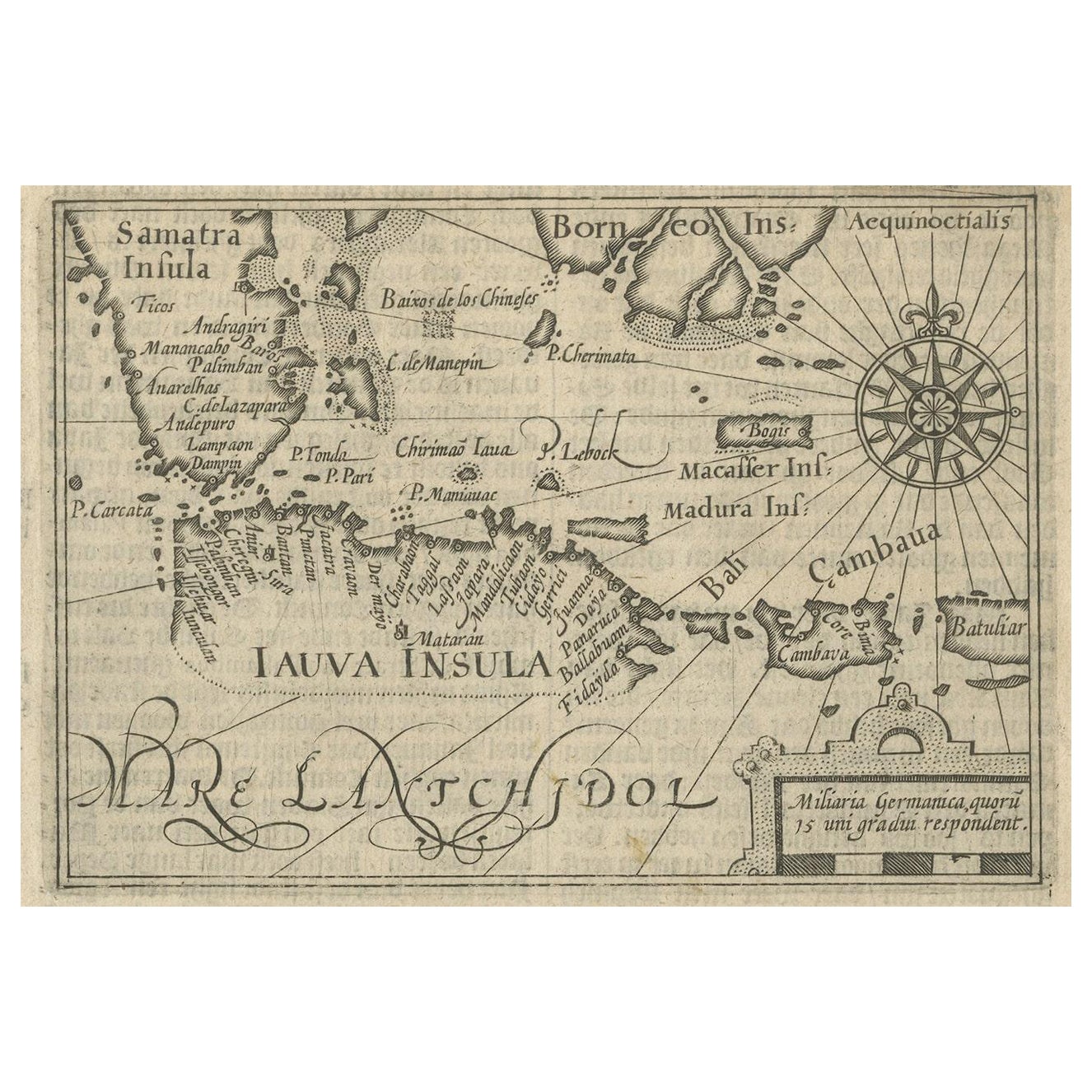
- Rare Small Map of Sumatra, Java, Borneo, Macassar, Madura, Bali, 1614Located in Langweer, NLOne of the first maps of the Indonesia islands of Java, Bali, Sumbawa etc. in early days of the Dutch Indies. Also showing Banten, Jakarta (Jacatra), Indr...Category
Antique Early 17th Century Maps
MaterialsPaper
- Antique Map of the Island of Borneo in Asia (Indonesia), 1726Located in Langweer, NLAntique map titled 'Kaart van het Eyland Borneo'. Early map of the island of Borneo. This map originates from 'Oud en Nieuw Oost-Indiën' by F. Valentijn. Artists and Engravers: Fran...Category
Antique 18th Century Maps
MaterialsPaper


You May Also Like
- England, Scotland & Ireland: A Hand Colored Map of Great Britain by TirionBy Isaak TirionLocated in Alamo, CAThis is a hand-colored double page copperplate map of Great Britain entitled "Nieuwe Kaart van de Eilanden van Groot Brittannien Behelzende de Kon...Category
Antique Mid-18th Century Dutch Maps
MaterialsPaper
- Original Antique Map of Asia. C.1780Located in St Annes, LancashireGreat map of Asia Copper-plate engraving Published C.1780 Two small worm holes to right side of map Unframed.Category
Antique Early 1800s English Georgian Maps
MaterialsPaper

- Large Original Antique Map of Java and Borneo, Fullarton, C.1870Located in St Annes, LancashireGreat map of Java and Borneo Wonderful figurative borders From the celebrated Royal Illustrated Atlas Lithograph. Original color. Published by Fullarton, Edinburgh. C.1870 Unfr...Category
Antique 1870s Scottish Maps
MaterialsPaper
- Original Antique Map of South East Asia by Thomas Clerk, 1817Located in St Annes, LancashireGreat map of South East Asia Copper-plate engraving Drawn and engraved by Thomas Clerk, Edinburgh. Published by Mackenzie And Dent, 1817 Unframed.Category
Antique 1810s English Maps
MaterialsPaper
- Original Antique Map of South East Asia by Becker, circa 1840Located in St Annes, LancashireGreat map of South East Asia Steel engraving with original color outline Engraved by Becker Published by Virtue, circa 1840. Unframed.Category
Antique 1840s English Other Maps
MaterialsPaper
- Original Antique Map of South East Asia, Arrowsmith, 1820Located in St Annes, LancashireGreat map of South East Asia Drawn under the direction of Arrowsmith Copper-plate engraving Published by Longman, Hurst, Rees, Orme and Brown, 1820 Unframed.Category
Antique 1820s English Maps
MaterialsPaper


Recently Viewed
View AllMore Ways To Browse
Singapore Antique
Singapore Antique Furniture
Map Of Singapore
Singapore Map
Antique Map Southeast
Southeast Asia Map
Antique Maps Singapore
Antique Map Singapore
Cambodia Antique Map
Isaak Tirion On Sale
Antique Furniture South East London
Antique Island Caribbean
Atlas Stand
Teak Sphere
Antique Battle Maps
Reclaimed Lumber
Map Of Virginia
Pirate Antique