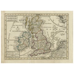
Antique Map of England, Scotland and Ireland by Keizer & de Lat, 1788
View Similar Items


Want more images or videos?
Request additional images or videos from the seller
1 of 5
Antique Map of England, Scotland and Ireland by Keizer & de Lat, 1788
About the Item
- Dimensions:Height: 8.08 in (20.5 cm)Width: 10.83 in (27.5 cm)Depth: 0.02 in (0.5 mm)
- Materials and Techniques:
- Period:
- Date of Manufacture:1788
- Condition:Small splits on folding lines. General age-related toning. Original folding lines. Original/contemporary hand coloring, blank verso. Minor wear, please study image carefully.
- Seller Location:Langweer, NL
- Reference Number:Seller: BG-12854-111stDibs: LU3054321979042
About the Seller
5.0
Platinum Seller
These expertly vetted sellers are 1stDibs' most experienced sellers and are rated highest by our customers.
Established in 2009
1stDibs seller since 2017
1,914 sales on 1stDibs
More From This SellerView All
- Antique Map of Switzerland by Keizer & de Lat, 1788Located in Langweer, NLAntique map titled 'La Suisse (..)'. Uncommon original antique map of Switzerland. This map originates from 'Nieuwe Natuur- Geschied- en Handelkundige Zak- en Reisatlas' by Gerrit Br...Category
Antique Late 18th Century Maps
MaterialsPaper
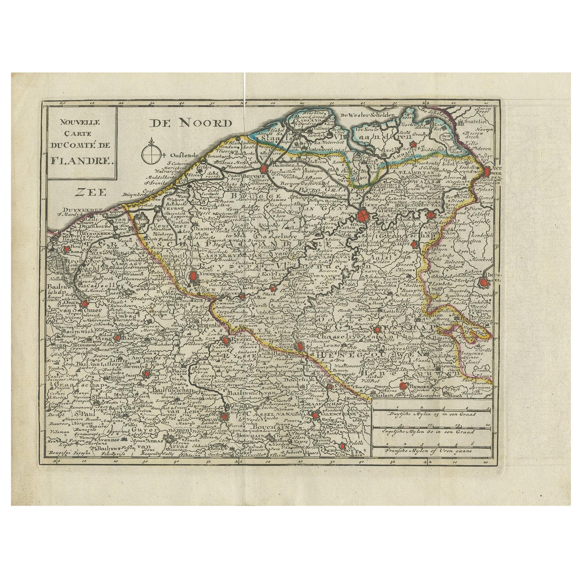
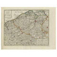
- Antique Map of Flanders by Keizer & de Lat, 1788Located in Langweer, NLAntique map titled 'Nouvelle Carte du Comté de Flandre'. Uncommon original antique map of Flanders, Belgium. This map originates from 'Nieuwe Natuur- Geschied- en Handelkundige Zak- ...Category
Antique Late 18th Century Maps
MaterialsPaper
- Antique Map of Greece by Keizer & de Lat, 1788Located in Langweer, NLAntique map titled 't Zuider Deel van Turks Europe genaamt Griekenland (..)'. Uncommon original antique map of Greece. This map originates from 'Nieuwe Natuur- Geschied- en Handelkun...Category
Antique Late 18th Century Maps
MaterialsPaper
- Antique Map of Africa by Keizer & de Lat, 1788Located in Langweer, NLAntique map titled 'Kaartje van Africa (..)'. Uncommon original antique map of Africa. This map originates from 'Nieuwe Natuur- Geschied- en Handelkundige Zak- en Reisatlas' by Gerri...Category
Antique Late 18th Century Maps
MaterialsPaper
- Antique Map of Italy by Keizer & de Lat, 1788Located in Langweer, NLAntique map titled 'Kaart van Italie (..)'. Uncommon original antique map of Italy. This map originates from 'Nieuwe Natuur- Geschied- en Handelk...Category
Antique Late 18th Century Maps
MaterialsPaper
 $286 Sale Price25% Off
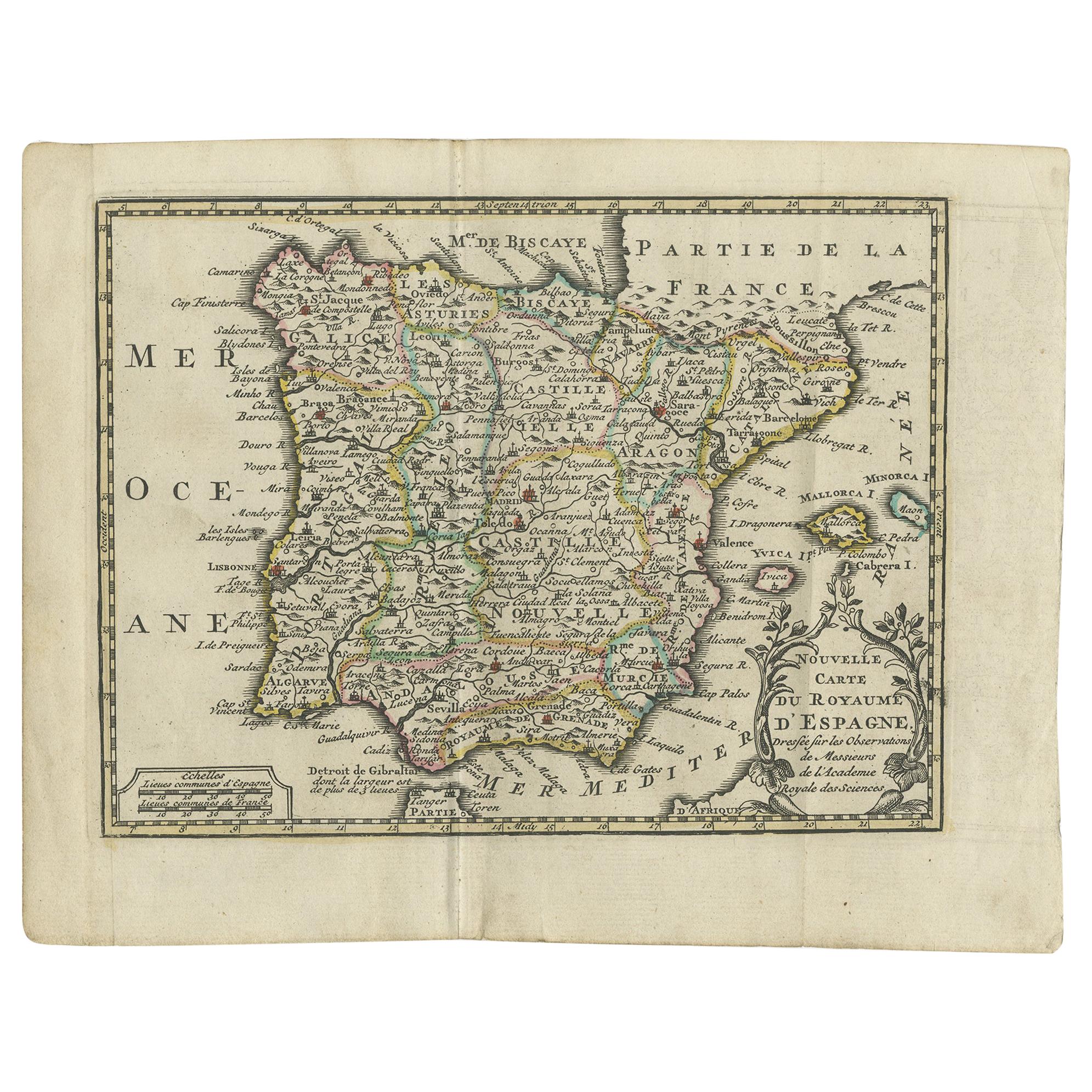
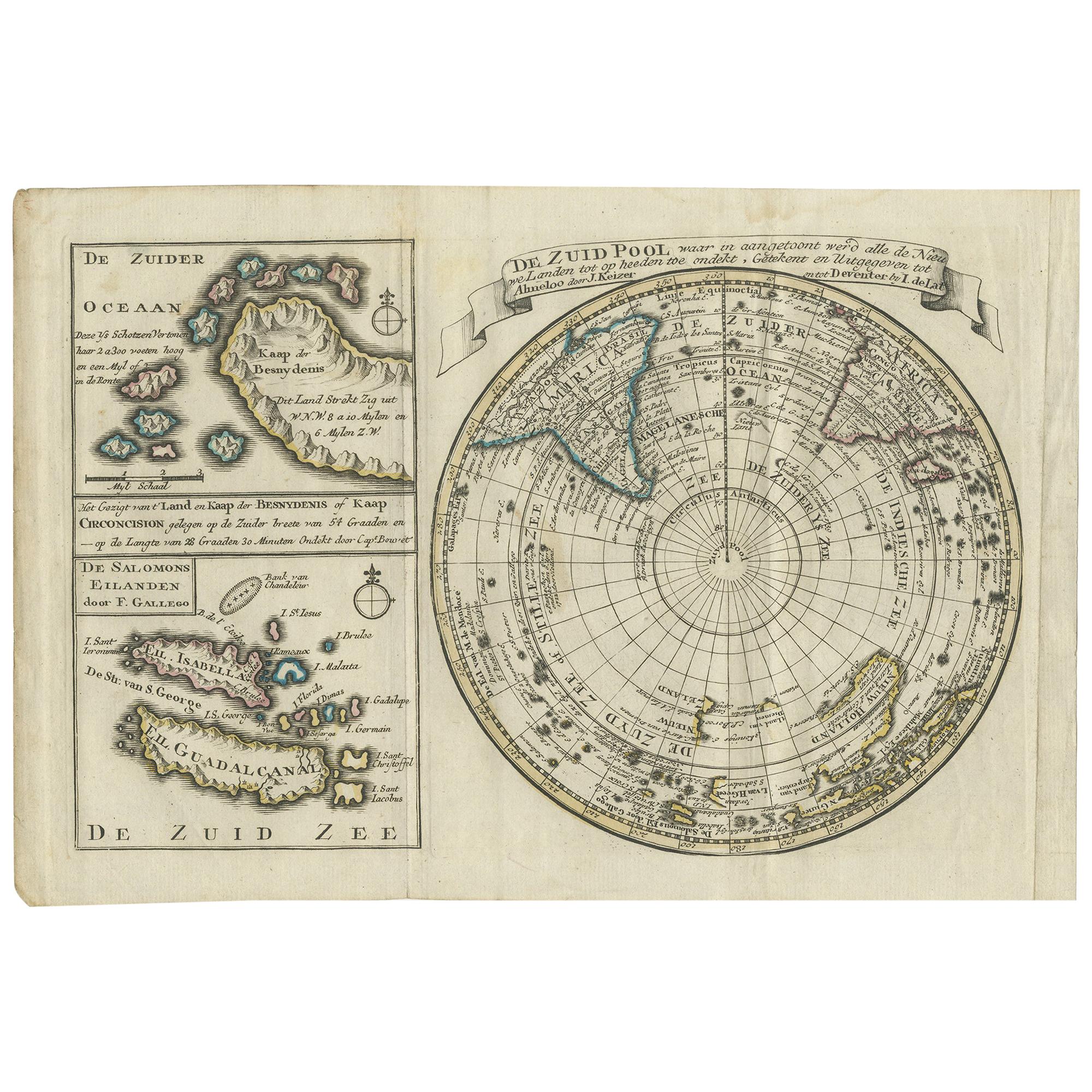
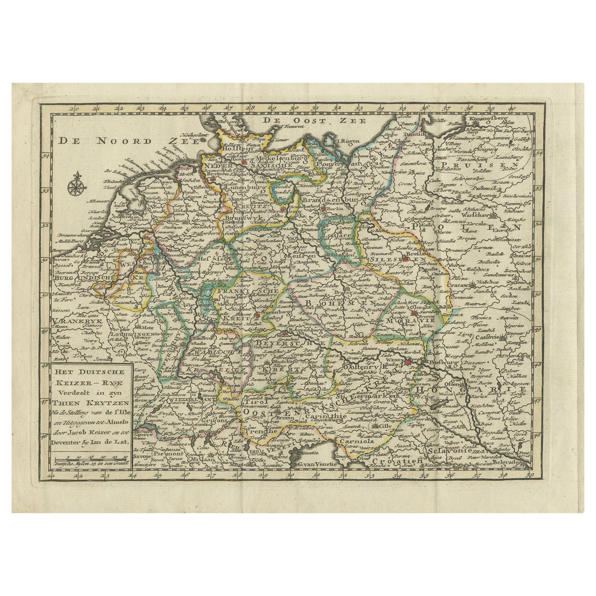
 - Antique Map of Europe by Keizer & de Lat, 1788Located in Langweer, NLAntique map titled 'Kaartje van Europa (..)'. Uncommon original antique map of Europe. This map originates from 'Nieuwe Natuur- Geschied- en Handelkundige Zak- en Reisatlas' by Gerri...Category
Antique Late 18th Century Maps
MaterialsPaper


You May Also Like
- England, Scotland & Ireland: A Hand Colored Map of Great Britain by TirionBy Isaak TirionLocated in Alamo, CAThis is a hand-colored double page copperplate map of Great Britain entitled "Nieuwe Kaart van de Eilanden van Groot Brittannien Behelzende de Kon...Category
Antique Mid-18th Century Dutch Maps
MaterialsPaper
- Original Antique Map of Ireland- Tipperary and Waterford. C.1840Located in St Annes, LancashireGreat map of Tipperary and Waterford Steel engraving Drawn under the direction of A.Adlard Published by How and Parsons, C.1840 Unframed.Category
Antique 1840s English Maps
MaterialsPaper
- Original Antique Map of Ireland- Kerry. C.1840Located in St Annes, LancashireGreat map of Kerry Steel engraving Drawn under the direction of A.Adlard Published by How and Parsons, C.1840 Unframed.Category
Antique 1840s English Maps
MaterialsPaper

- Old Horizontal Map of EnglandBy TassoLocated in Alessandria, PiemonteST/520 - Old rare Italian map of England, dated 1826-1827 - by Girolamo Tasso, editor in Venise, for the atlas of M.r Le-Sage.Category
Antique Early 19th Century Italian Other Prints
MaterialsPaper
 $235 Sale Price20% Off
 - Large 17th Century Hand Colored Map of England and the British Isles by de WitBy Frederick de WitLocated in Alamo, CAA large hand colored 17th century map of England and the British Isles by Frederick de Wit entitled "Accuratissima Angliæ Regni et Walliæ Principatus", published in Amsterdam in 1680. It is a highly detailed map of England, Scotland, the Scottish Isles...Category
Antique Late 17th Century Dutch Maps
MaterialsPaper
- “A Football Match, Scotland v. England” Antique Engraving, Proof Edition of 100By Overend and SmytheLocated in Colorado Springs, COThis is the 1889 William H. Overend (1851-1898) and Lionel Smythe (1839-1918) first edition, photogravure of the Calcutta Cup – a Rugby match between Scotland and England, that has been played over 100 times, the first match...Category
Antique 19th Century English Prints
MaterialsPaper


Recently Viewed
View AllMore Ways To Browse
Op Ocean Pacific
Historical Balkan Map
Map Of Edinburgh
Set Wall Pocket
Bassett China
Mapp Plate
Map Of Maine Et Loire
Historical Framed World Map
Antique Maps Washington Dc
Britton And Rey Lithograph
Cartier 1730
Christoph Weigel On Sale
Dao Antique Map
Eso Antique Maps
J Karte
Pero India
Old Teak Petite Artisan
Rand Mcnally Map Of California