Items Similar to Antique Map of the Holy Land Described in the Old and New Testament, ca.1660


Want more images or videos?
Request additional images or videos from the seller
1 of 5
Antique Map of the Holy Land Described in the Old and New Testament, ca.1660
About the Item
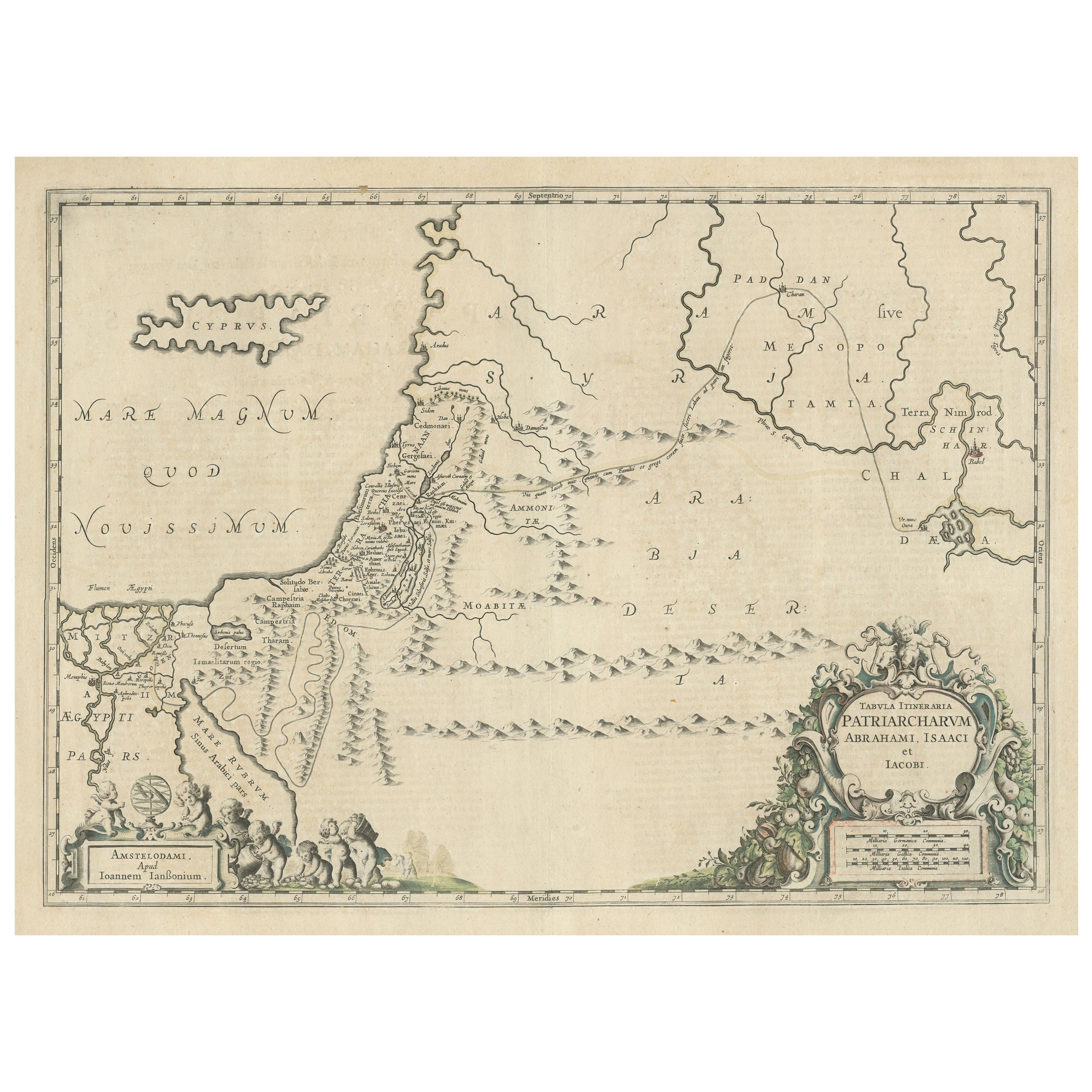
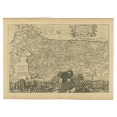
Antique map titled 'Geographiae Sacrae ex Veteri et Novo Testamento Desumptae Tabula Prima quae Totius Orbis Partes Continet.'
Map of the lands described in the Old and New Testament with only biblical place names indicated. The inset at bottom left balances the composition opposite the decorative title cartouche. Titled, Israelitarum Mansiones in Deserto (the stations of the Israelites in the desert), it is a small map of the route of the Exodus. Source unknown, to be determined.
Artists and Engravers: Made by 'Nicholas Sanson d'Abbeville' after an anonymous artist. Nicholas Sanson d'Abbeville (1600 - 1667) and his descendents were important French cartographer's active through the 17th century. Sanson started his career as a historian where, it is said, he turned to cartography as a way to illustrate his historical studies. In the course of his research some of his fine maps came to the attention of King Louis XIII who, admiring the quality of his work, appointed Sanson 'Geographe Ordinaire du Roi'. Sanson's duties in this coved position included advising the King on matters of Geography and compiling the royal cartographic archive. Sanson's corpus of some three hundred maps initiated the golden age of French Cartography.
Condition: Good, given age. Small repaired tear lower right edge. Two tiny worm holes; backed. Some minor crinkles and creases. Irregular bottom edge with an occasional tiny tear. Original folds as issued. General age-related toning and/or occasional minor defects from handling. Please study image carefully.
- Dimensions:Height: 16.15 in (41 cm)Width: 21.46 in (54.5 cm)Depth: 0 in (0.02 mm)
- Materials and Techniques:
- Period:1660-1669
- Date of Manufacture:circa 1660
- Condition:Repaired: Small repaired tear lower right edge. Two tiny worm holes; backed. Some minor crinkles and creases. Irregular bottom edge with an occasional tiny tear. Original folds as issued. General age-related toning. Wear consistent with age and use. Some minor crinkles and creases. Irregular bottom edge with an occasional tiny tear. Original folds as issued. General age-related toning and/or occasional minor defects from handling. Please study image carefully.
- Seller Location:Langweer, NL
- Reference Number:Seller: PCT-61943 1stDibs: LU3054326752012
About the Seller
5.0
Platinum Seller
These expertly vetted sellers are 1stDibs' most experienced sellers and are rated highest by our customers.
Established in 2009
1stDibs seller since 2017
1,913 sales on 1stDibs
Typical response time: <1 hour
- ShippingRetrieving quote...Ships From: Langweer, Netherlands
- Return PolicyA return for this item may be initiated within 14 days of delivery.
Auctions on 1stDibs
Our timed auctions are an opportunity to bid on extraordinary design. We do not charge a Buyer's Premium and shipping is facilitated by 1stDibs and/or the seller. Plus, all auction purchases are covered by our comprehensive Buyer Protection. Learn More
More From This SellerView All
- Antique Map of the Holy Land, c.1717Located in Langweer, NLAntique map Israel titled 'Tabula Geographica Terrae Sanctae'. Rare edition made after a map of the Holy Land by J. Bonfrerius. The map is oriented ...Category
Antique 18th Century Maps
MaterialsPaper
- Antique Map of the Holy Land, c.1710Located in Langweer, NLAntique map titled 'Totius Terrae Sanctae Delineatio'. Map of the Holy Land extending to Egypt and showing the route of the Children of Israel in their e...Category
Antique 18th Century Maps
MaterialsPaper
- Antique Map of the Holy Land by Danckerts, c.1710Located in Langweer, NLAntique map titled 'Afbeeldinge van de Veertich-Iaarige Reyse der Kinderen Israëls uyt Egypten door de Roode Zee en de Woestyne tot in 't Beloofde Landt Canaan'. Map of the Holy Land...Category
Antique 18th Century Maps
MaterialsPaper
- Antique Map of the Holy Land by Schut, 1710Located in Langweer, NLAntique map of the Holy Land titled 'Het Beloofde Landt Canaan.' Very detailed and decorative map of the Holy Land embellished with sailing ships and com...Category
Antique 18th Century Maps
MaterialsPaper
- Antique Map of the Holy Land by Keur, 1748Located in Langweer, NLAntique Map Holy Land titled 'De Gelegentheyd van t'Paradys ende t'Landt Canaan, Mitsgaders d'eerst bewoonde Landen der Patriarchen'. Includes five decorative vignettes, including No...Category
Antique 18th Century Maps
MaterialsPaper
- Antique Map of the Holy Land by Keur, 1748Located in Langweer, NLAntique biblical map titled 'Perigrinatie ofte veertigh-Iarige Reyse der Kinderen Israels uyt Egypten door de Roode Zee ende de Woestyne tot in 't Beloof...Category
Antique 18th Century Maps
MaterialsPaper


You May Also Like
- The Holy Bible, Containing the Old and New Testaments, 1887Located in Colorado Springs, COThe Holy Bible, Containing the Old and New Testaments, Translated out of the Original Tongues: And with the Former Translations Diligently Compared and Revised, by His Majesty’s Spec...Category
Antique 1880s English Late Victorian Books
MaterialsLeather, Paper
- The Holy Land at the Time of Jesus: A 17th Century Dutch Map by VisscherBy Nicolaes Visscher IILocated in Alamo, CAThis detailed Dutch map entitled "Het Beloofe de Landt Canaan door wandelt van onsen Salichmaecker Iesu Christo, nessens syne Apostelen" by Nicolaes Visscher was published in Amsterd...Category
Antique Mid-17th Century Dutch Maps
MaterialsPaper
- 17th Century John Speed Map of the Barkshire Described, c.1616By John SpeedLocated in Royal Tunbridge Wells, KentAntique 17th century British very rare and original John Speed (1551-1629) map of the Barkshire Described, J. Sud and Georg Humble, publication (1616 or lat...Category
Antique 17th Century British Maps
MaterialsPaper
- Antique German Bible 1738 Martin Luther Old and New Testament European GermanyLocated in Greer, SCCollectible antique German Luther Bible, also known as " Lutherbibel " in Germany. The Lutherbibel is a German translation by the Protestant reformer Martin Luther, a New Testament t...Category
Antique Mid-18th Century German Other Books
MaterialsWood, Paper
- Flowers from The Holy Land souvenir bookLocated in East Geelong, VICContained within the olive wood covers of this Flowers from The Holy Land souvenir book are 11 thick cardboard pages, 10 of which have pressed flowers arranged on them. The flowers a...Category
Antique 1890s Israeli Books
MaterialsPaper
- Map of the Holy Land "Carte de la Syrie et de l'Egypte" by Pierre M. LapieBy Pierre M. LapieLocated in Alamo, CAAn early 19th century map of ancient Syria and Egypt entitled "Carte de la Syrie et de l'Egypte anciennes/dressée par M. Lapie, Colonel d'Etat Major, et...Category
Antique Early 19th Century French Maps
MaterialsPaper


Recently Viewed
View AllMore Ways To Browse
Antique Cartography
Antique French Balance
Antique French Balances
Route Map
Fine Antique Maps
Holy Land
The Holy Land
Antique New Testament
Ex Antiques
Biblical Antiques
Antique Corpus
17th Century Corpus
Biblical Maps
Antique Furniture East London
Antique Eastern European Furniture
Antique House Plans
Antique Metal Window
Antique Metal Windows