Items Similar to Antique Map of the Mediterranean, Telemachus' Journey, Publ. Early 18th Century

Want more images or videos?
Request additional images or videos from the seller
1 of 6
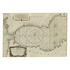
Antique Map of the Mediterranean, Telemachus' Journey, Publ. Early 18th Century
About the Item
Title: Carte des voyages de Télémaque.
Description: Antique map of Telemachus journey, the son of Odysseus and Penelope (Greek mythology ). This map appeared for the first time, engraved by Berey, in The Adventures of Telemachus, Paris, F. Delaulne, 1717, published by the Marquis de Fenelon. Interesting because Fenelon imagined travels of his hero as a geography similar to that card. The map allowed the reader to follow this route, it also had an educational function by teaching the geography of ancient peoples.
This interesting map is from “The Adventures of Telemachus” which is a didactic French novel by Fénelon, the Archbishop of Cambrai, and tutor to the seven-year-old Duc de Bourgogne (grandson of Louis XIV and second in line to the throne). The plot fills out a gap in Homer's Odyssey, recounting the travels of Telemachus, son of Ulysses, accompanied by his tutor, Mentor, who is revealed at the end of the story to be Minerva, goddess of wisdom, in disguise. The map that tracks the voyage of Telemachus was by S. Bousset was engraved by Hulett. It features a decorative title cartouche with an angel holding a drape.
- Dimensions:Height: 6.5 in (16.5 cm)Width: 10.63 in (27 cm)Depth: 0 in (0.02 mm)
- Materials and Techniques:Paper,Engraved
- Period:
- Date of Manufacture:circa 1730
- Condition:Folding lines as published, but very neatly flattened. Three small tears in the margin - not affecting the image - have been backed by small pieces of tape on the backside. Feel free to ask more details or photos.
- Seller Location:Langweer, NL
- Reference Number:
About the Seller
5.0
Platinum Seller
These expertly vetted sellers are 1stDibs' most experienced sellers and are rated highest by our customers.
Established in 2009
1stDibs seller since 2017
1,914 sales on 1stDibs
Typical response time: <1 hour
- ShippingRetrieving quote...Ships From: Langweer, Netherlands
- Return PolicyA return for this item may be initiated within 14 days of delivery.
More From This SellerView All
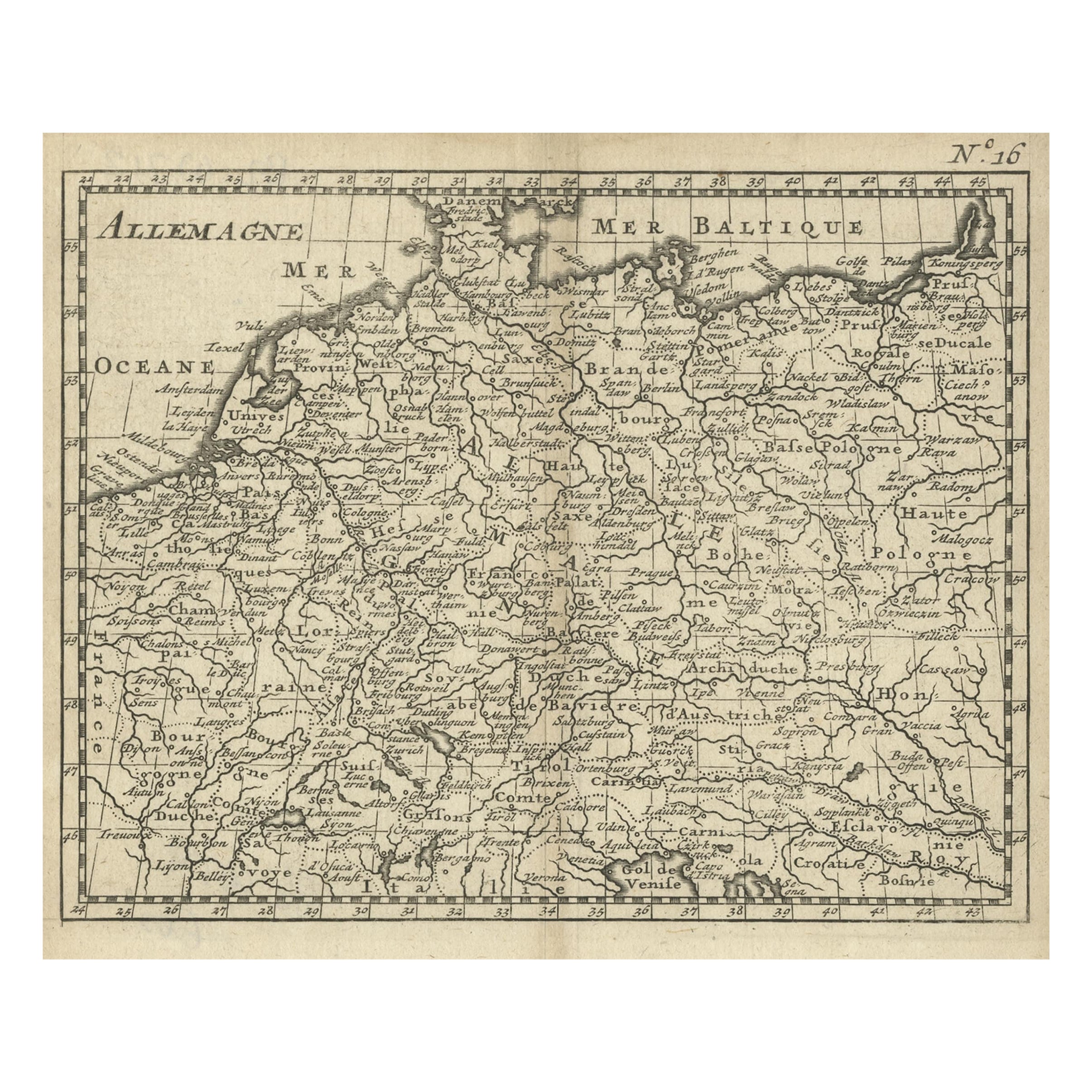
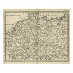
- Antique Copper Engraved Map of Germany in the Early 18th Century, c.1740Located in Langweer, NLAntique map Germany titled 'Allemagne'. Rare miniature map of Germany and surroundings. Also depicting the Baltic Sea and the Gulf of Venice. S...Category
Antique 18th Century Maps
MaterialsPaper
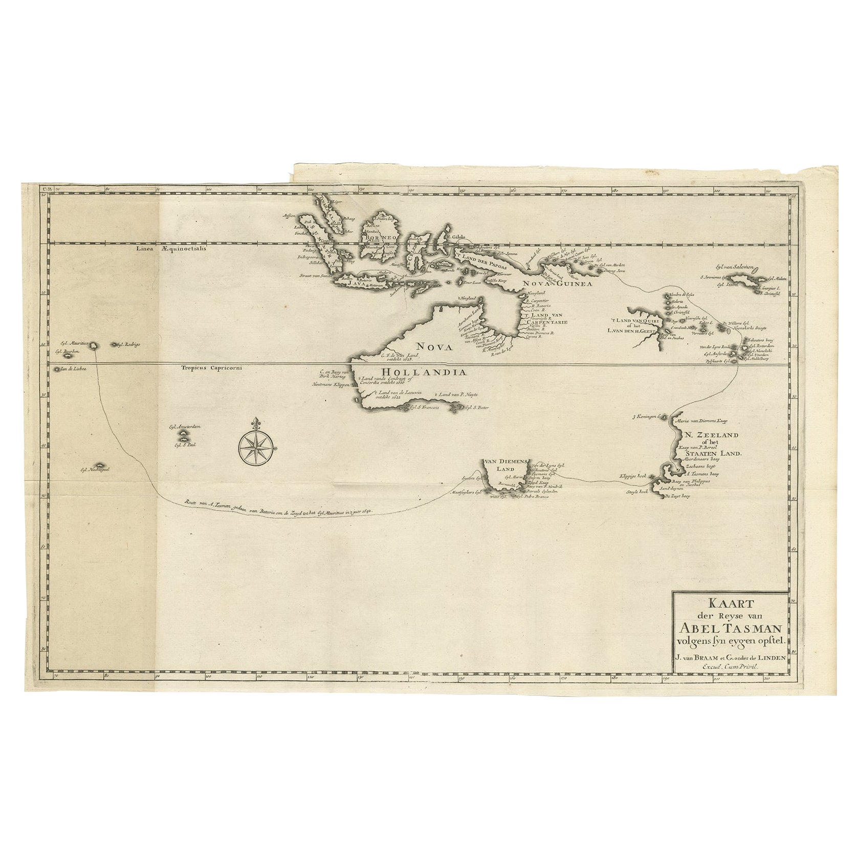
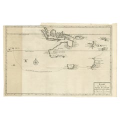
- Early Map of Australasia, Marking The Route of Abel Tasman in 1642 'Publ. 1726'Located in Langweer, NLDescription: Antique map titled 'Kaart der Reyse van Abel Tasman volgens syn eygen opstel'. Rare and early map of Australasia, marking the route of Abel Tasman's voyage from Mauritius to Batavia in 1642, on which he discovered Tasmania and New Zealand and proved that Australia was not part of the Great Southern...Category
Antique 1720s Maps
MaterialsPaper
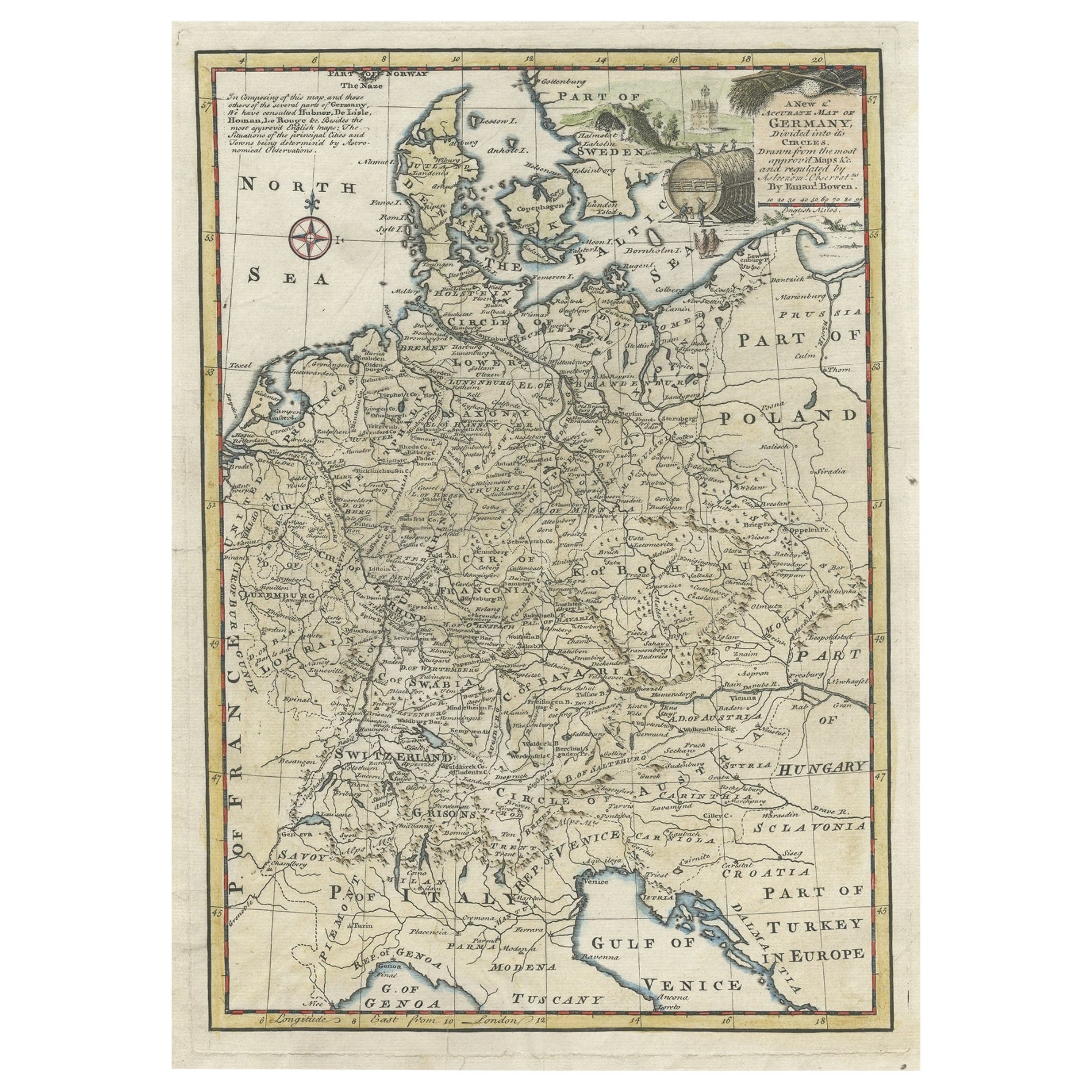
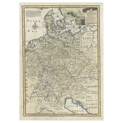
- Antique Map of Germany During the Mid-18th Century, Published in 1747Located in Langweer, NLAntique map Germany titled 'A New & Accurate Map of Germany'. It covers Germany during the mid-18th century, which included all of modern day Germany, Austria, Switzerland, Czech Rep...Category
Antique 18th Century Maps
MaterialsPaper
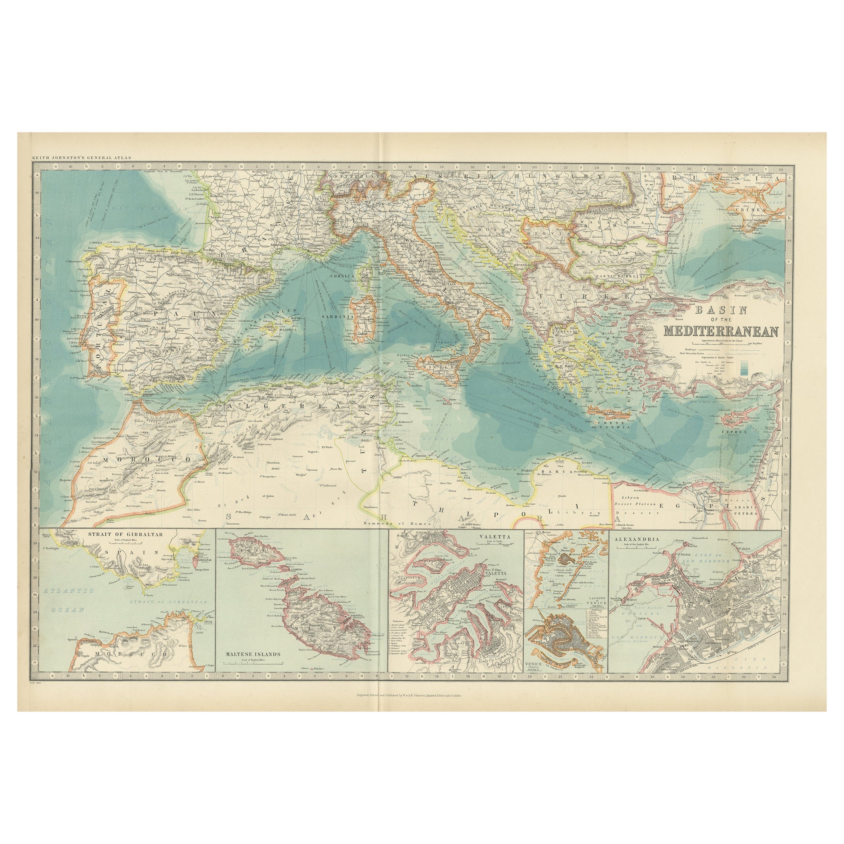
- Antique Map of the Basin of the Mediterranean by Johnston '1909'Located in Langweer, NLAntique map titled 'Basin of the Mediterranean'. Original antique map of the basin of the Mediterranean. With inset maps of the Strait of Gibraltar, Morocco, Maltese Islands, Valetta...Category
Early 20th Century Maps
MaterialsPaper
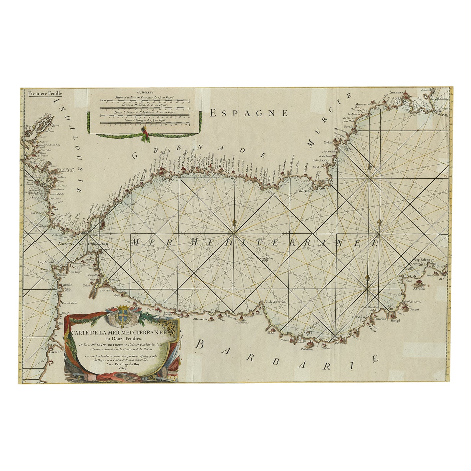
- Large Decorative Antique Map of the Mediterranean, ca.1770Located in Langweer, NLAntique map titled 'Carte de la Mer Mediterranee en Douze Feuilles'. First map out of twelve fine engraved double-page and folding maps that join to create a large wall map...Category
Antique 1770s Maps
MaterialsPaper
- Small Early 18th Century Map of Banten Bay on the Island Java, Indonesia, c.1725Located in Langweer, NLA small early 18th century map of Banten Bay showing the islands of Pulo Dua and Pulo Batto together with soundings within the Bay and profiles of hills on the islands published by C...Category
Antique 1720s Maps
MaterialsPaper

You May Also Like
- Antique 18th Century Map of the Province of Pensilvania 'Pennsylvania State'Located in Philadelphia, PAA fine antique of the colony of Pennsylvania. Noted at the top of the sheet as a 'Map of the province of Pensilvania'. This undated and anonymous map is thought to be from the Gentleman's Magazine, London, circa 1775, although the general appearance could date it to the 1760's. The southern boundary reflects the Mason-Dixon survey (1768), the western boundary is placed just west of Pittsburgh, and the northern boundary is not marked. The map has a number of reference points that likely refer to companion text and appear to be connected to boundaries. The western and southern boundaries are marked Q, R, S, for example. A diagonal line runs from the Susquehanna R to the Lake Erie P. A broken line marked by many letters A, B, N, O, etc., appears in the east. There are no latitude or longitude markings, blank verso. Framed in a shaped contemporary gilt wooden frame and matted under a cream colored matte. Bearing an old Graham Arader Gallery...Category
Antique 18th Century British American Colonial Maps
MaterialsPaper
- Hand-Colored 18th Century Homann Map of the Danube, Italy, Greece, CroatiaBy Johann Baptist HomannLocated in Alamo, CA"Fluviorum in Europa principis Danubii" is a hand colored map of the region about the Danube river created by Johann Baptist Homann (1663-1724) in his 'Atlas Novus Terrarum', publish...Category
Antique Early 18th Century German Maps
MaterialsPaper
- The Kingdom of Naples and Southern Italy: A Hand-Colored 18th Century Homann MapBy Johann Baptist HomannLocated in Alamo, CA"Novissima & exactissimus Totius Regni Neapolis Tabula Presentis Belli Satui Accommo Data" is a hand colored map of southern Italy and the ancient Kingdom of Naples created by Johann...Category
Antique Early 18th Century German Maps
MaterialsPaper
- Germany West of the Rhine: A Hand-colored 18th Century Map by de WitBy Frederick de WitLocated in Alamo, CAThis original 18th century hand-colored map of the county of Moers, Germany entitled "Illustrissimo Celsissmo Principi GUILIELMO HENRICO D.G. Arausionum Principi Domino suo Clementis...Category
Antique Early 18th Century Dutch Maps
MaterialsPaper
- Hand Colored 18th Century Homann Map of Austria Including Vienna and the DanubeBy Johann Baptist HomannLocated in Alamo, CA"Archiducatus Austriae inferioris" is a hand colored map of Austria created by Johann Baptist Homann (1663-1724) and published in Nuremberg, Germany in 1728 shortly after his death. ...Category
Antique Early 18th Century German Maps
MaterialsPaper
- Hand-Colored 18th Century Homann Map of the Black Sea, Turkey and Asia MinorBy Johann Baptist HomannLocated in Alamo, CAAn attractive original early 18th century hand-colored map of the Black Sea and Turkey entitled "Carte de L'Asie Minevre ou de la Natolie et du Pont Evxin Tiree des Voyages et des Ob...Category
Antique Early 18th Century German Maps
MaterialsPaper


Recently Viewed
View AllMore Ways To Browse
Mediterranean Antique
Antique Mediterranean Furniture
Collectable Angel
Antique Angels Collectibles
Marquis Louis
Carte Paris
Maps Of Mediterranean
Antique Marquis
Antique Minerva
Goddess Minerva
Antique Map Mediterranean
Marquis A Paris
Map Mediterranean
Antique Mediterranean Map
Ancient Greek Map
Map Of Ancient Greece
Antique Maps Of Ancient Greece
Used Nautical Charts