Items Similar to Antique Map of Northwest Africa by Bartholomew, 1922

Want more images or videos?
Request additional images or videos from the seller
1 of 5
Antique Map of Northwest Africa by Bartholomew, 1922
About the Item
Antique map of Africa titled 'North-West Africa'. Old map of north-west Africa depicting Morocco, Algeria, Tunis and surroundings. This map originates from 'The Times' atlas. Artists and Engravers: John George Bartholomew (22 March 1860 ? 14 April 1920) was a British cartographer and geographer. As a holder of a royal warrant, he used the title "Cartographer to the King"; for this reason he was sometimes known by the epithet "the Prince of Cartography". Bartholomew's longest lasting legacy is arguably naming the continent of Antarctica, which until his use of the term in 1890 had been largely ignored due to its lack of resources and harsh climate.
Artist: John George Bartholomew (22 March 1860 ? 14 April 1920) was a British cartographer and geographer. As a holder of a royal warrant, he used the title "Cartographer to the King"; for this reason he was sometimes known by the epithet "the Prince of Cartography". Bartholomew's longest lasting legacy is arguably naming the continent of Antarctica, which until his use of the term in 1890 had been largely ignored due to its lack of resources and harsh climate.
Condition: Very good, please study image carefully.
Date: 1922
Overall size: 59 x 45.5 cm.
Image size: 0.001 x 55.5 x 41.5 cm.
Antique prints have long been appreciated for both their aesthetic and investment value. They were the product of engraved, etched or lithographed plates. These plates were handmade out of wood or metal, which required an incredible level of skill, patience and craftsmanship. Whether you have a house with Victorian furniture or more contemporary decor an old engraving can enhance your living space. We offer a wide range of authentic antique prints for any budget.
- Dimensions:Height: 17.92 in (45.5 cm)Width: 23.23 in (59 cm)Depth: 0 in (0.01 mm)
- Materials and Techniques:
- Period:
- Date of Manufacture:1922
- Condition:
- Seller Location:Langweer, NL
- Reference Number:
About the Seller
5.0
Platinum Seller
These expertly vetted sellers are 1stDibs' most experienced sellers and are rated highest by our customers.
Established in 2009
1stDibs seller since 2017
1,909 sales on 1stDibs
Typical response time: <1 hour
- ShippingRetrieving quote...Ships From: Langweer, Netherlands
- Return PolicyA return for this item may be initiated within 14 days of delivery.
More From This SellerView All
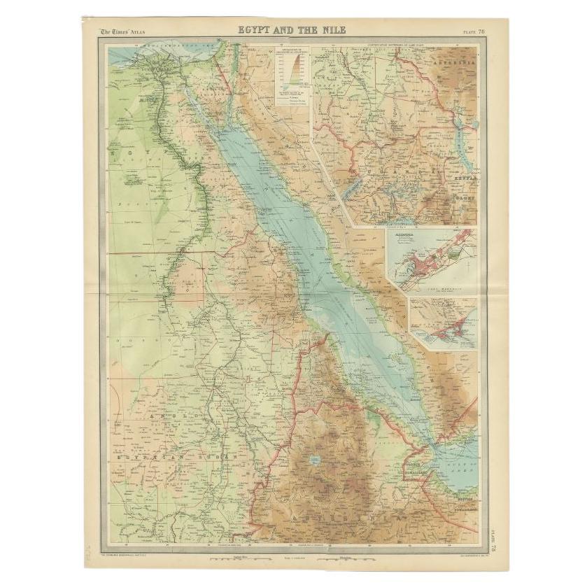
- Antique Map of the Region of the Nile River by Bartholomew, 1922Located in Langweer, NLAntique map of Africa titled 'Egypt and the Nile'. Old map of Africa depicting Egypt, the Nile river and surroundings. This map originates from 'The Times' ...Category
20th Century Maps
MaterialsPaper
- Antique Map of the Coast of Northwest Africa by Dien, 1820Located in Langweer, NLAntique map Africa titled 'Partie Occidentale de l'Ancien Continent, depuis Lisbonne jusquá la Riviere de Sierra Leona'. Detailed map of Coastal Nor...Category
Antique 19th Century Maps
MaterialsPaper
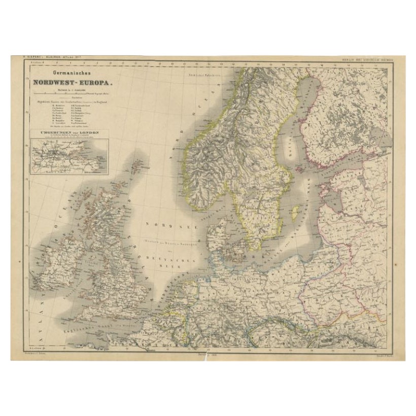
- Antique Map of Northwest Europe by Kiepert, c.1870Located in Langweer, NLAntique map titled 'Germanisches Nordwest-Europa'. Old map of North-West Europe depicting the United Kingdom, Ireland, the Netherlands, Germany, Scandinavia and surroundings. This ma...Category
Antique 19th Century Maps
MaterialsPaper
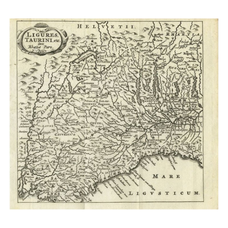
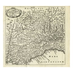
- Antique Map of Northwest Italy by Cluver, 1685Located in Langweer, NLAntique map titled 'Ligures, Taurini, etc.' Miniature map of northwest Italy. From the pocket atlas 'Introductionis in Universam Geographiam tam Veterem quam novam .. Acessit P. Bert...Category
Antique 17th Century Maps
MaterialsPaper
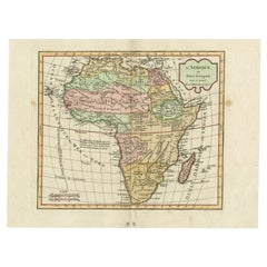
- Antique Map of Africa by Delamarche, 1806Located in Langweer, NLAntique map titled 'L'Afrique'. Decorative map of Africa by Robert de Vaugondy, revised and published by Delamarche. Source unknown, to be determined. Artists and Engravers: Charl...Category
Antique 19th Century Maps
MaterialsPaper
- Antique Map of Africa by Lapie, 1842Located in Langweer, NLAntique map titled 'Carte d'Afrique'. Map of Africa. This map originates from 'Atlas universel de géographie ancienne et moderne (..)' by Pierre M. Lapie...Category
Antique Mid-19th Century Maps
MaterialsPaper

You May Also Like
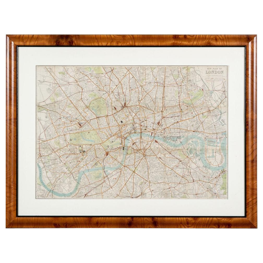
- Antique "New Plan of London" Map by John Bartholomew, 1900Located in Bridgeport, CTProduced for the W.H. Smith guide, folded in the original. The map here is unfolded and framed flat, with transportation routes shown and color details. sight 22 x 32" (original ful...Category
Antique Early 1900s English Victorian Maps
MaterialsPaper
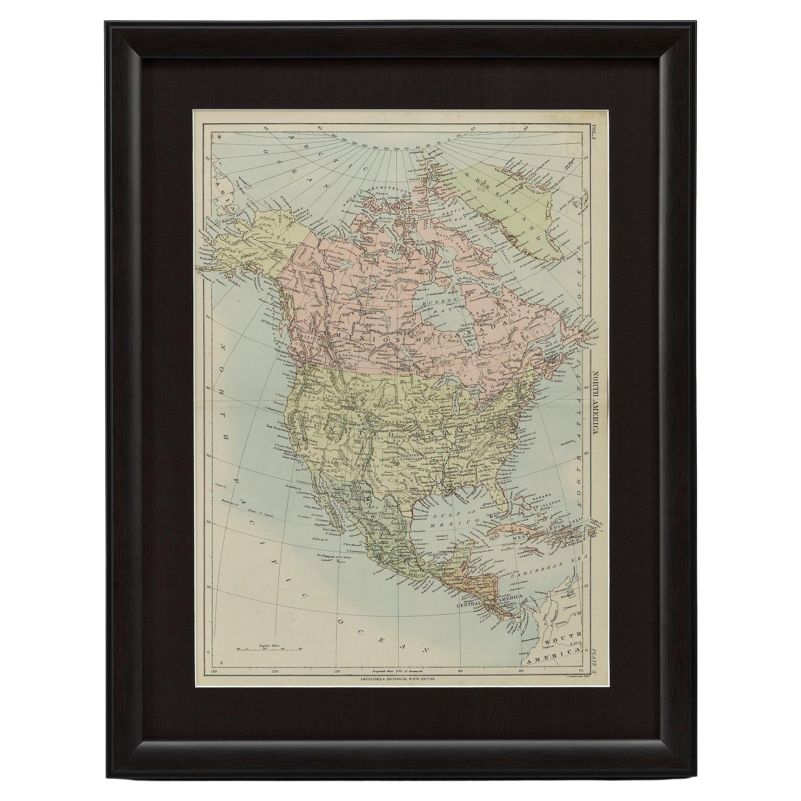
- 1875 "North America" Map by J. BartholomewLocated in Colorado Springs, COPresented is an original 1875 map of “North America.” The map was issued in Volume 1 of the Ninth Edition of the Encyclopædia Britannica, published in Edinburgh. The map was drawn by famous Scottish mapmaker John Bartholomew. The map depicts North America, to include Greenland, the Dominion of Canada, the United States, Mexico, the countries of Central America, and the islands of the West Indies. Prominent rivers, mountain ranges, and cities are labeled on the map, and country borders are emphasized in red. The Encyclopædia Britannica has been published continuously since 1768, appearing in fifteen official editions. The landmark ninth edition of the Encyclopædia Britannica, often called "the Scholar's Edition," was published from January 1875 to 1889 in 25 volumes. The editor and author of the “Foreword” was Thomas Spencer Baynes, the first English-born editor after a series of Scots. After 1880, Baynes was assisted by William Robertson Smith. The 9th edition is often lauded as a high point among early editions for scholarship. The 9th edition was far more luxurious than any previously printed Encyclopædia Britannicas, with thick boards and quality leather bindings, premier paper, and a production which took full advantage of the technological advances of printing in the years between the 1850s and 1870s. The publishers took advantage of the new ability to print large graphic illustrations on the same pages as the text, as opposed to limiting illustrations to separate copper plate engravings. Although this technology had first been used in a primitive fashion the 7th edition, and to a much lesser extent in the 8th, in the 9th edition there were thousands of quality illustrations and maps set...Category
Antique 1870s Scottish Maps
MaterialsPaper
- Northwest Coast and Isle of Man MapLocated in Cheshire, GBGreenville Collins Northwest Coast and Isle of Man. hand coloured chart, encased in an ebonised frame. Dimensions Height 26.5 Inches Width 30 Inches Depth 1 InchesCategory
Early 20th Century British Maps
MaterialsPaper
- Original Antique Map of South Africa, Arrowsmith, 1820Located in St Annes, LancashireGreat map of South Africa. Drawn under the direction of Arrowsmith. Copper-plate engraving. Published by Longman, Hurst, Rees, Orme and Br...Category
Antique 1820s English Maps
MaterialsPaper
- London 1744 Published Watercolour Antique Map of East Africa by Eman BowenLocated in GBWe are delighted to offer for sale this New and Accurate Map of Nubia & Abissinia, together with all the Kingdoms Tributary Thereto, and bordering upon them published in 1744 by Emanuel Bowen This is a decorative antique engraved map of East Africa...Category
Antique 1740s English George III Maps
MaterialsPaper
- Large University Chart “Physical Map of Africa” by BaconLocated in Chillerton, Isle of WightLarge university chart “Physical Map of Africa” by Bacon W&A K Johnston’s Charts of Physical Maps By G W Bacon, This is colorful Physical map of North America, it is large lithograph set...Category
Early 20th Century Folk Art Posters
MaterialsLinen


Recently Viewed
View AllMore Ways To Browse
1922 Furniture
Northwest Vintage
Antique Prince And
April Antiques
Vintage Decor Collectibles
20th Century Africa Collectibles
Royal British Antiques
Royal Warrant
African Plate
Legacy Antiques
West African Antiques
Victorian African
Antique Map Britain
Antique Britain Map
North Africa Map
North By Northwest
Morocco Map
West Africa Map