Items Similar to Antique Map of Part of the Chinese Coast, Explored by the French, Ca.1852
Want more images or videos?
Request additional images or videos from the seller
1 of 6
Antique Map of Part of the Chinese Coast, Explored by the French, Ca.1852
About the Item
Antique map titled 'Plan du Golfe D'Anville (Côte de Tartarie)'.
Old map of part of the Chinese coast, explored with the French corvette 'Caprieuse'. The Capricieuse was a late 22-gun corvette of the French Navy. Capricieuse was commissioned under Arnault de Gorse on 1 September 1849. From 1850, she served in the Far East under Captain Rocquemaurel, returning to Toulon in 1854. She then took part in the Crimean War as a troopship. Capricieuse returned to China in 1856. In 1858, she took part in the Battle of Canton, being present at the capture of the city on 30 January and at the Battle of Taku Forts.
Artists and Engravers: Drawn by A. Blanchard, engraved by Jacobs.
Condition: Very good, general age-related toning. Minor wear, please study image carefully.
- Dimensions:Height: 20.08 in (51 cm)Width: 26.38 in (67 cm)Depth: 0 in (0.02 mm)
- Materials and Techniques:
- Period:
- Date of Manufacture:circa 1852
- Condition:Condition: Very good, general age-related toning. Minor wear, please study image carefully.
- Seller Location:Langweer, NL
- Reference Number:
About the Seller
5.0
Platinum Seller
These expertly vetted sellers are 1stDibs' most experienced sellers and are rated highest by our customers.
Established in 2009
1stDibs seller since 2017
1,909 sales on 1stDibs
Typical response time: <1 hour
- ShippingRetrieving quote...Ships From: Langweer, Netherlands
- Return PolicyA return for this item may be initiated within 14 days of delivery.
More From This SellerView All
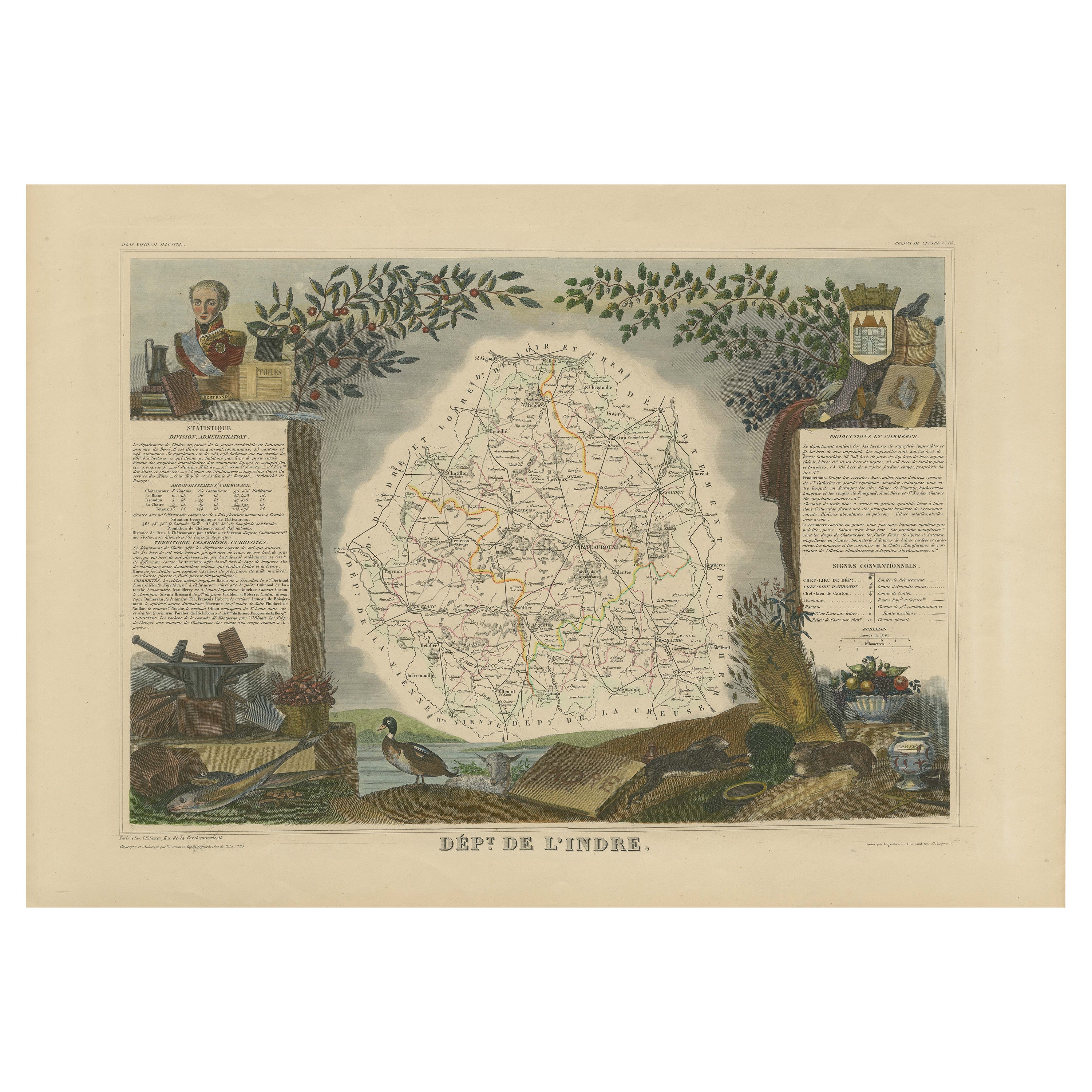
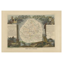
- Antique Map of the Indre Region in France, ca. 1852Located in Langweer, NLAntique map titled 'Dépt. de l'Indre'. Map of the French department of Indre, France. Part of the Loire Valley wine region, this area is known for its production of Chinon wines, typically red, and production of Pouligny-Saint-Pierre, goats'-milk cheese. It is also the birthplace of the great philosopher Rene Descartes...Category
Antique Mid-19th Century Maps
MaterialsPaper
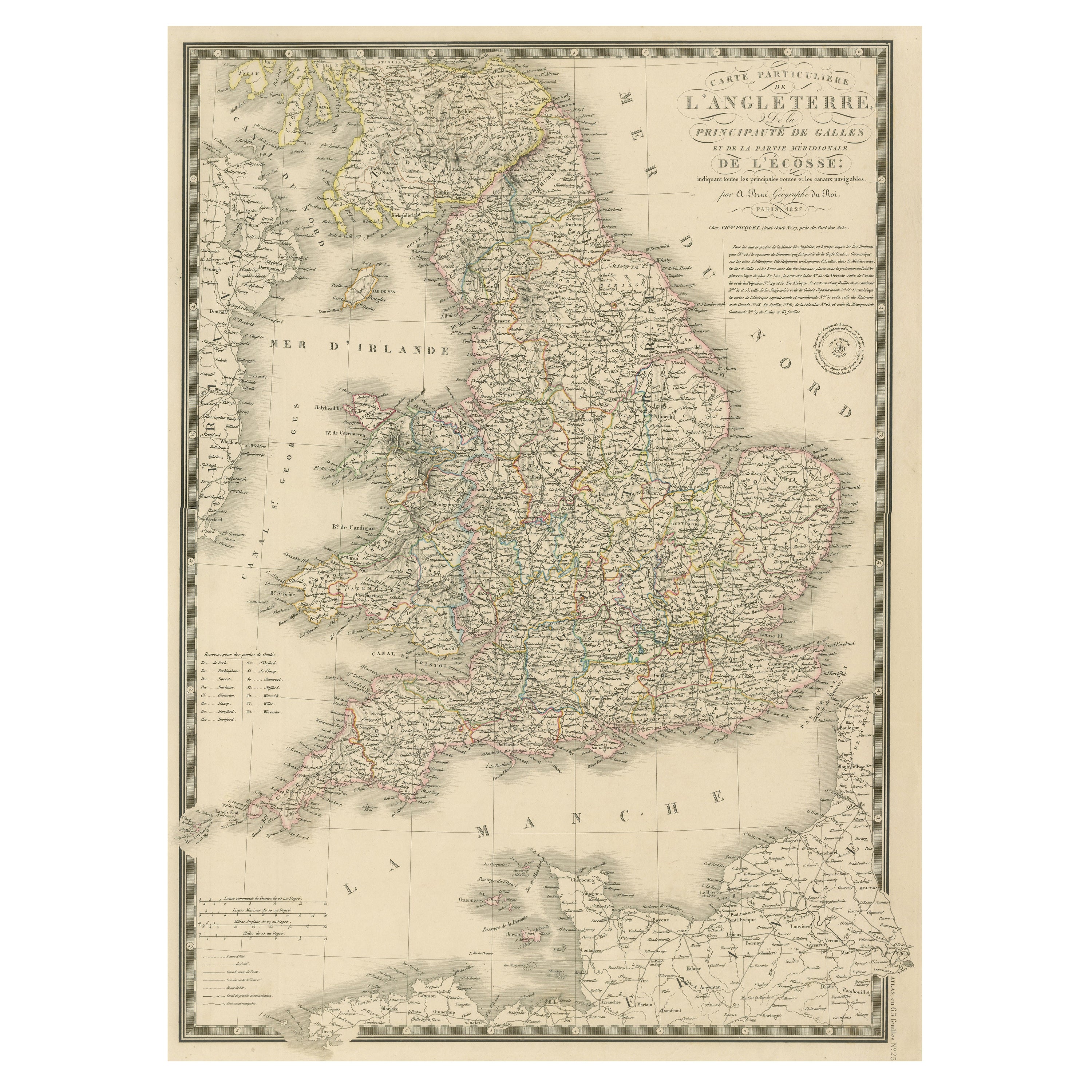
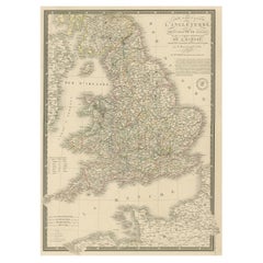
- Antique Map of the British Isles and Part of the Coast of FranceLocated in Langweer, NLAntique map titled 'Carte Particuliere l'Angleterre (..)'. Original antique map of the British Isles and part of the coast of France. It shows England and part of Wales. Published by...Category
Antique Mid-19th Century Maps
MaterialsPaper
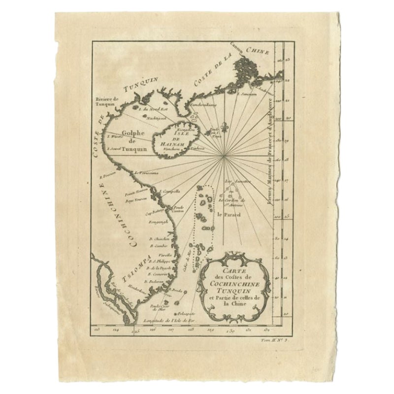
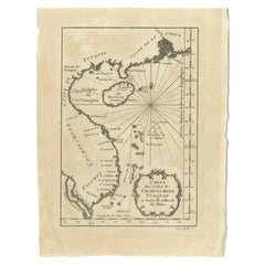
- Antique Map of the Coast of China by Bellin, 1752By Jacques-Nicolas BellinLocated in Langweer, NLAntique map titled 'Carte des Costes de Cochinchine, Tunquin et Partie de celles de Chine'. Detailed map of the region from the Cambodia River to Macao, along the coast of China. ...Category
Antique 18th Century Maps
MaterialsPaper
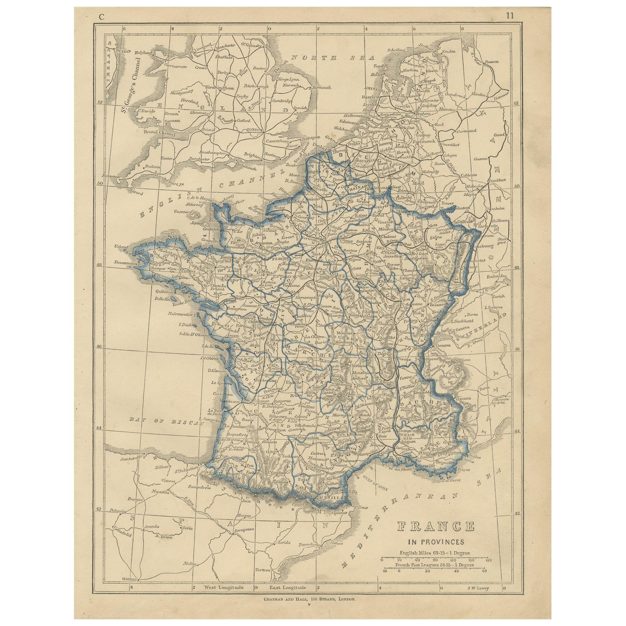
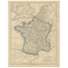
- Antique Map of France by Lowry, '1852'Located in Langweer, NLAntique map titled 'France in Provinces'. Original map of France. This map originates from 'Lowry's Table Atlas constructed and engraved from the most recent Authorities' by J.W. Low...Category
Antique Mid-19th Century Maps
MaterialsPaper
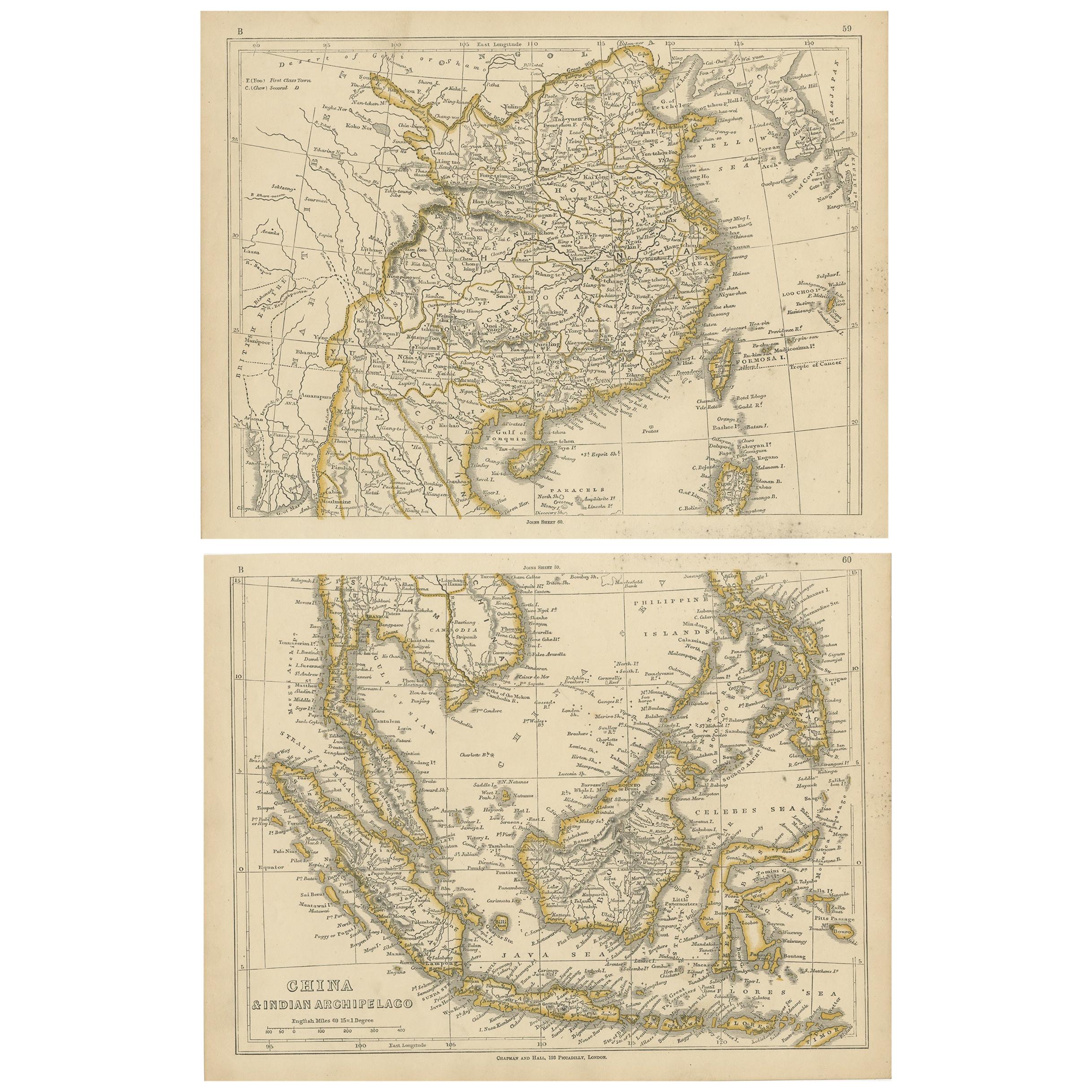
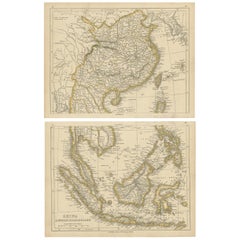
- Antique Map of China and the East Indies by Lowry, 1852Located in Langweer, NLAntique map titled 'China & Indian Archipelago'. Two individual sheets of China and the East Indies. This map originates from 'Lowry's table Atlas constructed and engraved from the m...Category
Antique Mid-19th Century Maps
MaterialsPaper
- Antique Map of the Coast of France, 1710By Jacobus HarrewijnLocated in Langweer, NLAntique map titled 'Les Embouchures de la Somme et de Bresle'. Map of the coast of Northern France showing the estuaries of the Somme and the Bresle. This map is part of a serie of...Category
Antique Early 18th Century Maps
MaterialsPaper

You May Also Like
- Map, Exploring The WorldLocated in New York City, NY300 stunning maps from all periods and from all around the world, exploring and revealing what maps tell us about history and ourselves. Selected by an international panel of cartographers, academics, map dealers and collectors, the maps represent over 5,000 years of cartographic innovation drawing on a range of cultures and traditions. Comprehensive in scope, this book features all types of map from navigation and surveys to astronomical maps, satellite and digital maps, as well as works of art inspired by cartography. Unique curated sequence presents maps in thought-provoking juxtapositions for lively, stimulating reading. Features some of the most influential mapmakers and institutions in history, including Gerardus Mercator, Abraham Ortelius, Phyllis Pearson, Heinrich Berann...Category
21st Century and Contemporary Hong Kong Books
MaterialsPaper
- Map Exploring The World, Midi FormatLocated in New York City, NYA compelling exploration of the ways that humans have mapped the world throughout history - now in a compact new edition Map: Exploring the World brings together more than 250...Category
21st Century and Contemporary Books
MaterialsPaper
- Super Rare Antique French Map of Chine and the Chinese Empire, 1780Located in Amsterdam, Noord HollandSuper Rare Antique French Map of Chine and the Chinese Empire, 1780 Very nice map of Asia. 1780 Made by Bonne. Additional information: Type: Map ...Category
Antique 18th Century European Maps
MaterialsPaper
- 1861 Topographical Map of the District of Columbia, by Boschke, Antique MapLocated in Colorado Springs, COPresented is an original map of Albert Boschke's extremely sought-after "Topographical Map of the District of Columbia Surveyed in the Years 1856 ...Category
Antique 1860s American Historical Memorabilia
MaterialsPaper
- Map of the Kingdom of Sardinia and Part of the Kingdom of Genoa, RomeBy Giovanni Maria CassiniLocated in Hamilton, Ontario18th century map by Italian engraver Giovanni Maria Cassini (Italy 1745-1824). Map of Part of the Kingdom of Sardinia and Part of the Kingdom of Genoa: Rome. This is a hand colored a...Category
Antique 18th Century Italian Maps
MaterialsPaper
- Original Antique Map of China by Thomas Clerk, 1817Located in St Annes, LancashireGreat map of China Copper-plate engraving Drawn and engraved by Thomas Clerk, Edinburgh. Published by Mackenzie And Dent, 1817 Unframed.Category
Antique 1810s English Maps
MaterialsPaper