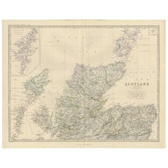
Antique Map of Scotland 'North' by A.K. Johnston, 1865
View Similar Items


Want more images or videos?
Request additional images or videos from the seller
1 of 2
Antique Map of Scotland 'North' by A.K. Johnston, 1865
About the Item
- Dimensions:Height: 19.1 in (48.5 cm)Width: 24.41 in (62 cm)Depth: 0.02 in (0.5 mm)
- Period:
- Date of Manufacture:1865
- Condition:General age-related toning. Please study image carefully.
- Seller Location:Langweer, NL
- Reference Number:Seller: BG-05553/71stDibs: LU3054310726973
About the Seller
5.0
Platinum Seller
These expertly vetted sellers are 1stDibs' most experienced sellers and are rated highest by our customers.
Established in 2009
1stDibs seller since 2017
1,909 sales on 1stDibs
More From This SellerView All
- Antique Map of Scotland 'South' by A.K. Johnston, 1865Located in Langweer, NLAntique map titled 'Scotland (Southern Sheet)'. This map originates from the ‘Royal Atlas of Modern Geography’ by Alexander Keith Johnston. Published by William Blackwood and Sons, E...Category
Antique Mid-19th Century Maps
MaterialsPaper
 $217 Sale Price27% Off
 - Antique Map of South America ‘North’ by A.K. Johnston, 1865Located in Langweer, NLAntique map titled 'South America, Northern Sheet'. Depicting Guiana, Ecuador, Brazil, Bolivia the Amazones and more. This map originates from the ‘Royal Atlas of Modern Geography’ b...Category
Antique Mid-19th Century Maps
MaterialsPaper
 $238 Sale Price20% Off
 - Antique Map of England and Wales 'North' by A.K. Johnston, 1865Located in Langweer, NLAntique map titled 'England and Wales (Northern Sheet)'. This map originates from the ‘Royal Atlas of Modern Geography’ by Alexander Keith Johnston. Published by William Blackwood an...Category
Antique Mid-19th Century Maps
MaterialsPaper
- Antique Map of Denmark by A.K. Johnston, 1865Located in Langweer, NLAntique map titled 'Denmark and the Duchies Schleswig, Holstein & Lauenburg; Hanover, Brunswick, Mecklenburg, Oldenburg, Anhalt and Lippe'. With an inset map of Iceland, Copenhagen a...Category
Antique Mid-19th Century Maps
MaterialsPaper
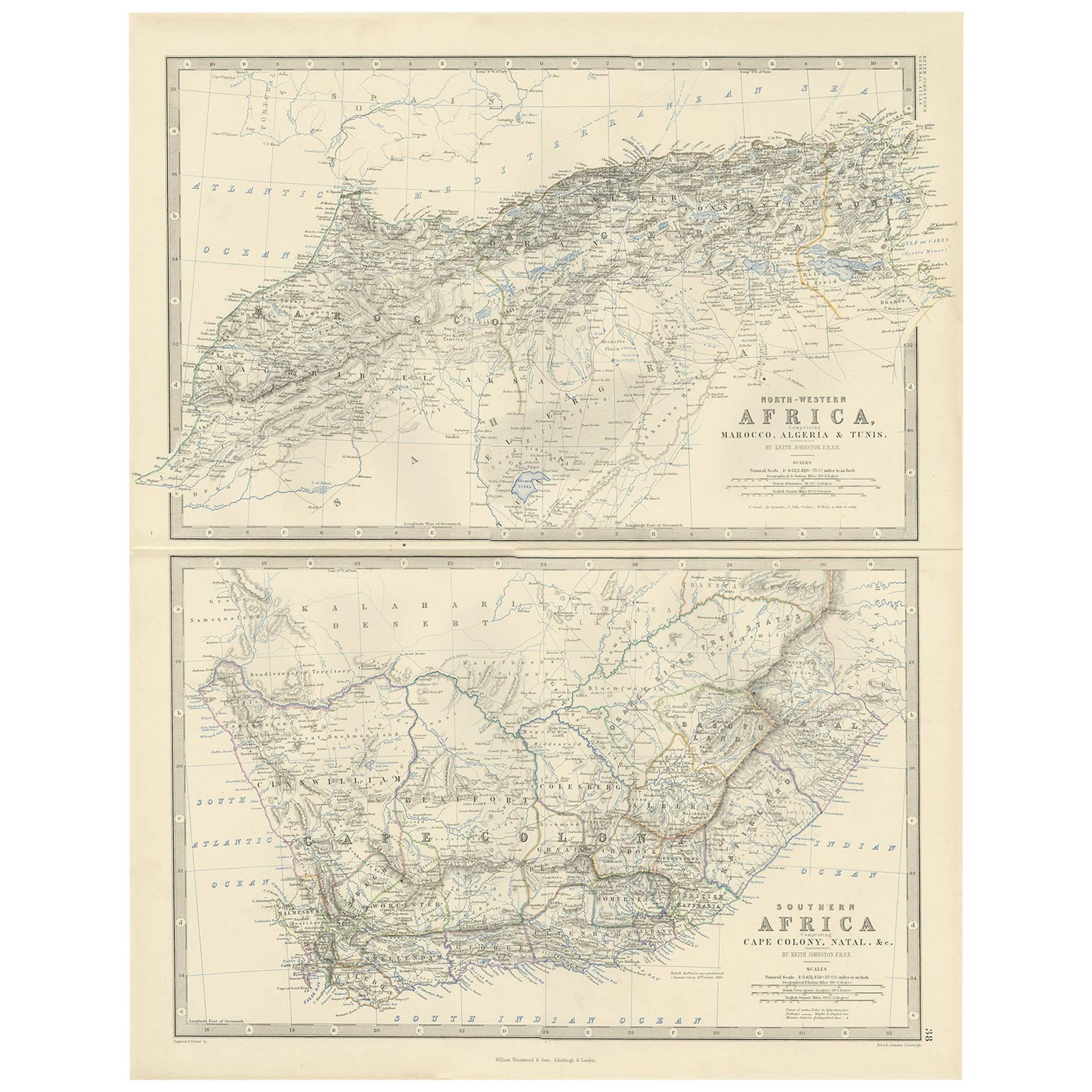
- Antique Map of North-Western and South Africa by A.K. Johnston, 1865Located in Langweer, NLTwo maps on one sheet titled 'North-Western Africa' and 'Southern Africa'. Depicting Morocco, Algeria, Tunis, Cape Colony, Natal and more. This map originates from the ‘Royal Atlas o...Category
Antique Mid-19th Century Maps
MaterialsPaper
 $260 Sale Price20% Off
 - Antique Map of South Australia by A.K. Johnston, 1865Located in Langweer, NLAntique map titled 'South Australia, New South Wales, Victoria & Queensland'. This map originates from the ‘Royal Atlas of Modern Geography’ by Alexander Keith Johnston. Published by...Category
Antique Mid-19th Century Maps
MaterialsPaper
 $260 Sale Price20% Off


You May Also Like
- Large Antique 1859 Map of North AmericaLocated in Sag Harbor, NYThis Map was made by Augustus Mitchell in 1859 It is in amazing condition for being 163 years old. This price is for the rolled up easy to ship version of this piece. I will be Frami...Category
Antique Mid-19th Century American Maps
MaterialsCanvas, Paper

- 1864 Map of North America, Antique Hand-Colored Map, by Adolphe Hippolyte DufourLocated in Colorado Springs, COOffered is a map of North America entitled Amerique du Nord from 1864. This rare, separately published wall map was produced by Adolphe Hippolyte Dufour. This map includes vibrant an...Category
Antique 1860s French Maps
MaterialsPaper
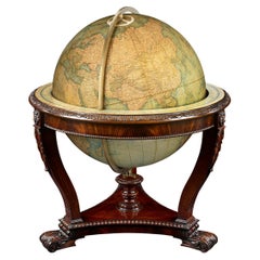
- Terrestrial Globe by W. & A.K. JohnstonBy W. & A.K. JohnstonLocated in New Orleans, LAMeasuring a monumental 30 inches in diameter, this impressive globe was crafted by the renowned firm W. & A.K. Johnston. Founded in 1825, the Johnston firm is considered the foremost...Category
Antique 19th Century English Victorian Globes
MaterialsBrass
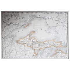
- Large Original Antique Map of Michigan 'North', USA, 1894By Rand McNally & Co.Located in St Annes, LancashireFabulous map of Michigan North. Original color. By Rand, McNally & Co. Published, 1894. Unframed. Free shipping.Category
Antique 1890s American Maps
MaterialsPaper
- 1875 "North America" Map by J. BartholomewLocated in Colorado Springs, COPresented is an original 1875 map of “North America.” The map was issued in Volume 1 of the Ninth Edition of the Encyclopædia Britannica, published in Edinburgh. The map was drawn by famous Scottish mapmaker John Bartholomew. The map depicts North America, to include Greenland, the Dominion of Canada, the United States, Mexico, the countries of Central America, and the islands of the West Indies. Prominent rivers, mountain ranges, and cities are labeled on the map, and country borders are emphasized in red. The Encyclopædia Britannica has been published continuously since 1768, appearing in fifteen official editions. The landmark ninth edition of the Encyclopædia Britannica, often called "the Scholar's Edition," was published from January 1875 to 1889 in 25 volumes. The editor and author of the “Foreword” was Thomas Spencer Baynes, the first English-born editor after a series of Scots. After 1880, Baynes was assisted by William Robertson Smith. The 9th edition is often lauded as a high point among early editions for scholarship. The 9th edition was far more luxurious than any previously printed Encyclopædia Britannicas, with thick boards and quality leather bindings, premier paper, and a production which took full advantage of the technological advances of printing in the years between the 1850s and 1870s. The publishers took advantage of the new ability to print large graphic illustrations on the same pages as the text, as opposed to limiting illustrations to separate copper plate engravings. Although this technology had first been used in a primitive fashion the 7th edition, and to a much lesser extent in the 8th, in the 9th edition there were thousands of quality illustrations and maps set...Category
Antique 1870s Scottish Maps
MaterialsPaper
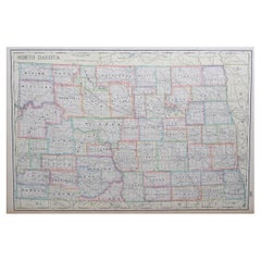
- Large Original Antique Map of North Dakota, USA, circa 1900Located in St Annes, LancashireFabulous map of North Dakota Original color Engraved and printed by the George F. Cram Company, Indianapolis. Published, circa 1900 Unframed Free shi...Category
Antique 1890s American Maps
MaterialsPaper