Items Similar to Antique Map of Southern Asia with India, the Maldives, Ceylon and Arabia, c.1700


Want more images or videos?
Request additional images or videos from the seller
1 of 6
Antique Map of Southern Asia with India, the Maldives, Ceylon and Arabia, c.1700
About the Item
Stunning Old Map of Asia.
Description: Two-sheet map of Asia, joined. The left part of this antique map is titled 'Partie occidentale d'une partie d'Asie ou sont les Isles de Zocotora, de l'Amirante'. The right part of this antique map is titled 'Carte Particuliere d'une Partie d'Asie ou sont Les Isles D'Andemaon, Ceylan, Les Maldives'.
This map depicts the Maldives, the Andaman Islands, and Ceylon (Sri Lanka). Sumatra peeks out of the eastern border, with the southwest peninsula showing the Kingdoms of Siam, Mataban, Pegu, and, to the north, Grant Thibet. Beautiful antique map of the Indian Ocean, extending from Saudi Arabia and the Horn of Africa in the west to the Straits of Malacca, with the focus centered on India and Pakistan. This antique map originates from 'Neptune Francois'.
Artists and Engravers: Pierre, or Pieter, Mortier (1661-1711) was a Dutch engraver, son of a French refugee.
Condition: Very good, minor defects from handling. Original, contemporary hand coloring. Upper border a bit short in the margin, but enough for framing. Please study images carefully.
- Dimensions:Height: 24.81 in (63 cm)Width: 37.01 in (94 cm)Depth: 0 in (0.02 mm)
- Materials and Techniques:
- Period:
- Date of Manufacture:circa 1700
- Condition:
- Seller Location:Langweer, NL
- Reference Number:
About the Seller
5.0
Platinum Seller
These expertly vetted sellers are 1stDibs' most experienced sellers and are rated highest by our customers.
Established in 2009
1stDibs seller since 2017
1,913 sales on 1stDibs
Typical response time: <1 hour
- ShippingRetrieving quote...Ships From: Langweer, Netherlands
- Return PolicyA return for this item may be initiated within 14 days of delivery.
More From This SellerView All
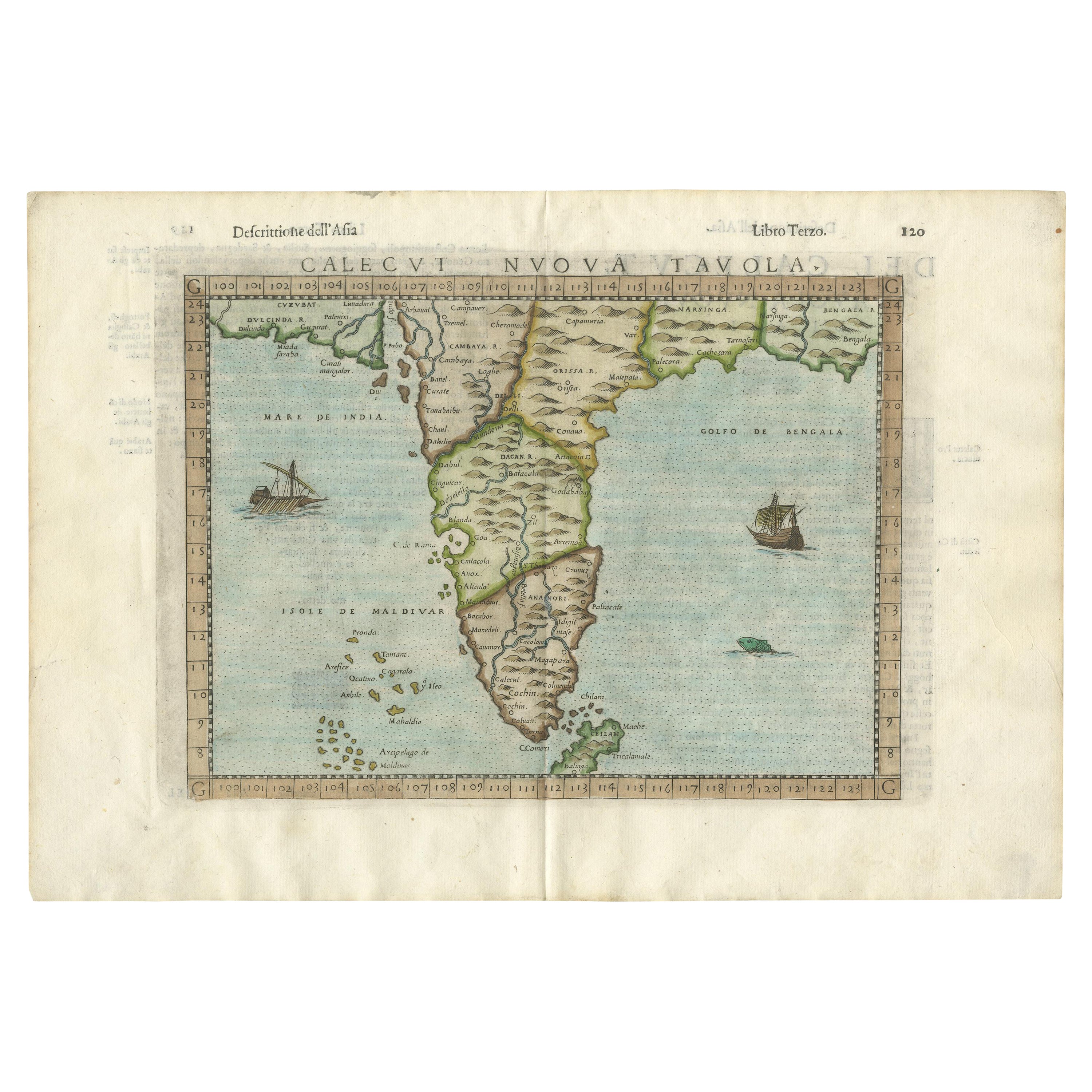
- Rare Attractive Antique Map of Asia, India, Sri Lanka, Maldives, 1599Located in Langweer, NLOriginal Antique map of Asia, India, Ceylon (Sri Lanka), Maldives by Rosaccio / Ruscelli in attractive coloring. Title: Calecut Nuova Tavola Year: 1599 Relief shown pictorially. ...Category
Antique 16th Century European Maps
MaterialsPaper
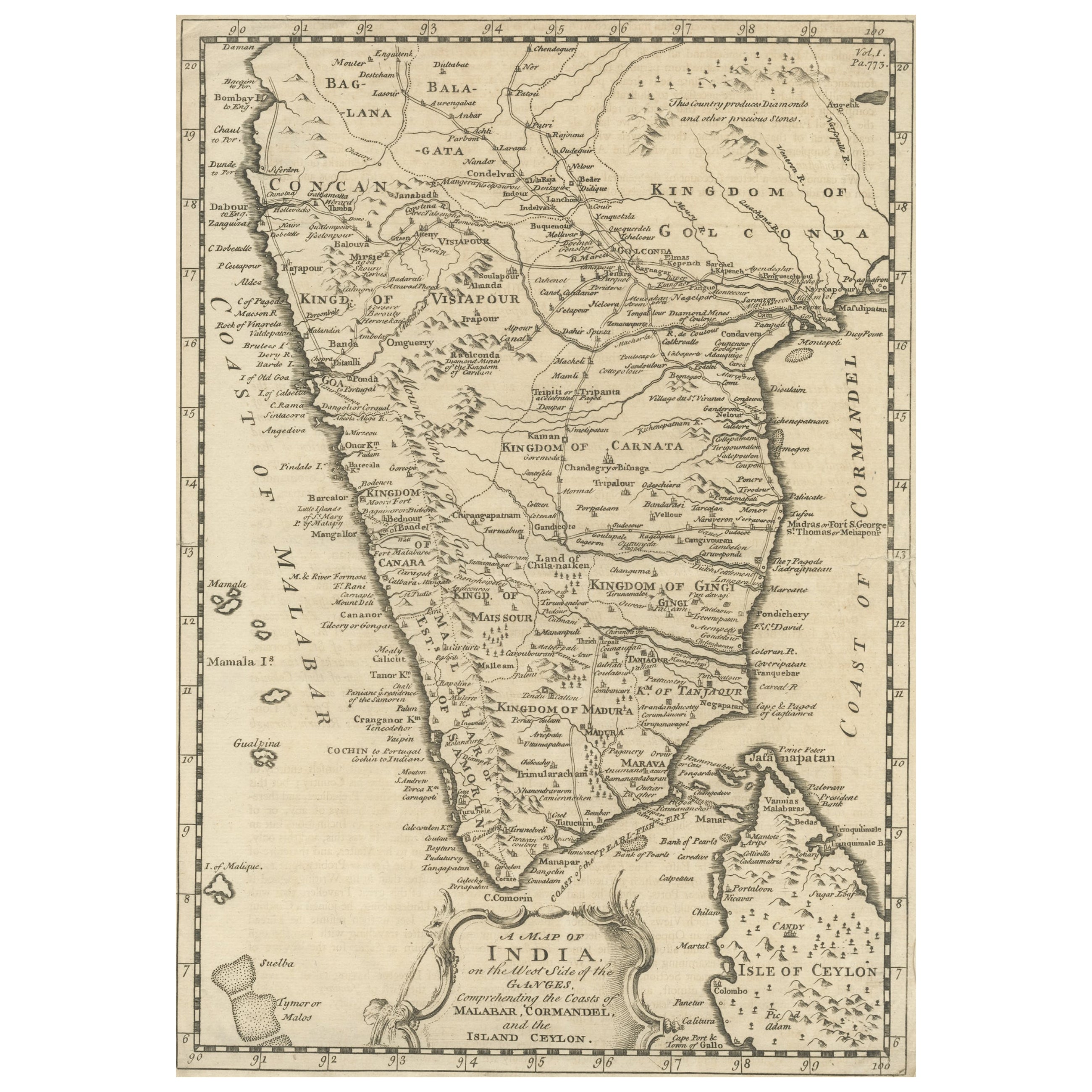
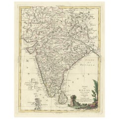
- Original Detailed Antique Map of Southern India and Most of Ceylon, 1744Located in Langweer, NLAntique map titled 'A Map of India on the west Side of the Ganges, comprehending the coasts of Malabar, Coromandel and the Island Ceylon'. Map of Southern India and most of Ceylo...Category
Antique 1740s Maps
MaterialsPaper
- Old Map of Southern India and Ceylon 'Sri Lanka', 1882Located in Langweer, NLAntique map titled 'India (Southern Sheet)'. Old map of Southern India and Ceylon (Sri Lanka). With an inset map of the South-Eastern Provinces of India. This map originates from...Category
Antique 1880s Maps
MaterialsPaper
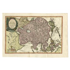
- Antique Map of Continental Asia, with Japan, Arabia, India, Russia, etc c.1702Located in Langweer, NLAntique map titled 'Totius Asiae Continens (..).' On this map of continental Asia and the adjacent islands Japan is shown with an oversized Terra Iedso (Hokkaido) connected with Honshu via a narrow isthmus. The Compagnie Land of the de Vries expedition is shown above, separated by a narrow strait named after the explorer. Nova Zembla is depicted correctly as an island, but the northeastern part of Siberia, the Chukchi peninsula and Kamchatka are missing. A portion of Australia is shown as Nova Hollandia...Category
Antique 18th Century Maps
MaterialsPaper
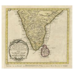
- Original Antique Map of Southern India and Ceylon 'Present-Day Sri Lanka'By Jakob van der SchleyLocated in Langweer, NLAntique map titled 'Suite de la Carte de l'Indoustan (..) - Vervolg van de Kaart van Hindoestan (..)'. Original antique map of Southern India and Ceylon (present-day Sri Lanka). This...Category
Antique Mid-18th Century Maps
MaterialsPaper
- Antique Map of India and Ceylon, along with the MaldivesLocated in Langweer, NLAntique map titled 'Stato del Mogol con l'Isole di Ceilan e Maldive'. Beautiful map of India and Ceylon, along with the Maldives. Includes a large decorative title cartouche. The map...Category
Antique Late 18th Century Maps
MaterialsPaper

You May Also Like
- Original Antique Map of India. C.1780Located in St Annes, LancashireGreat map of India Copper-plate engraving Published C.1780 Three small worm holes to right side of map and one bottom left corner Unframed.Category
Antique Early 1800s English Georgian Maps
MaterialsPaper

- Original Antique Map of Asia. C.1780Located in St Annes, LancashireGreat map of Asia Copper-plate engraving Published C.1780 Two small worm holes to right side of map Unframed.Category
Antique Early 1800s English Georgian Maps
MaterialsPaper

- Original Antique Map of South East Asia, Arrowsmith, 1820Located in St Annes, LancashireGreat map of South East Asia Drawn under the direction of Arrowsmith Copper-plate engraving Published by Longman, Hurst, Rees, Orme and Brown, 1820 Unframed.Category
Antique 1820s English Maps
MaterialsPaper
- The Kingdom of Naples and Southern Italy: A Hand-Colored 18th Century Homann MapBy Johann Baptist HomannLocated in Alamo, CA"Novissima & exactissimus Totius Regni Neapolis Tabula Presentis Belli Satui Accommo Data" is a hand colored map of southern Italy and the ancient Kingdom of Naples created by Johann...Category
Antique Early 18th Century German Maps
MaterialsPaper
- Original Antique Map of South East Asia by Thomas Clerk, 1817Located in St Annes, LancashireGreat map of South East Asia Copper-plate engraving Drawn and engraved by Thomas Clerk, Edinburgh. Published by Mackenzie And Dent, 1817 Unframed.Category
Antique 1810s English Maps
MaterialsPaper
- Original Antique Map of South East Asia by Becker, circa 1840Located in St Annes, LancashireGreat map of South East Asia Steel engraving with original color outline Engraved by Becker Published by Virtue, circa 1840. Unframed.Category
Antique 1840s English Other Maps
MaterialsPaper


Recently Viewed
View AllMore Ways To Browse
Southern Antiques
Antique Ceylon
Shorter And Sons
Southern India
Arabian Antique
Ceylon Furniture
Southwest Antique
France And Son Extending
India Map
Antique Center Islands
Ocean Maps
Ocean Map
Old Ceylon
Horn Of Africa
India Antique 18th Century
Southwest Antique Furniture
Map Of India
18th Century Southern Antiques