Items Similar to Antique Map of Stavoren by Merian, c.1650
Want more images or videos?
Request additional images or videos from the seller
1 of 5
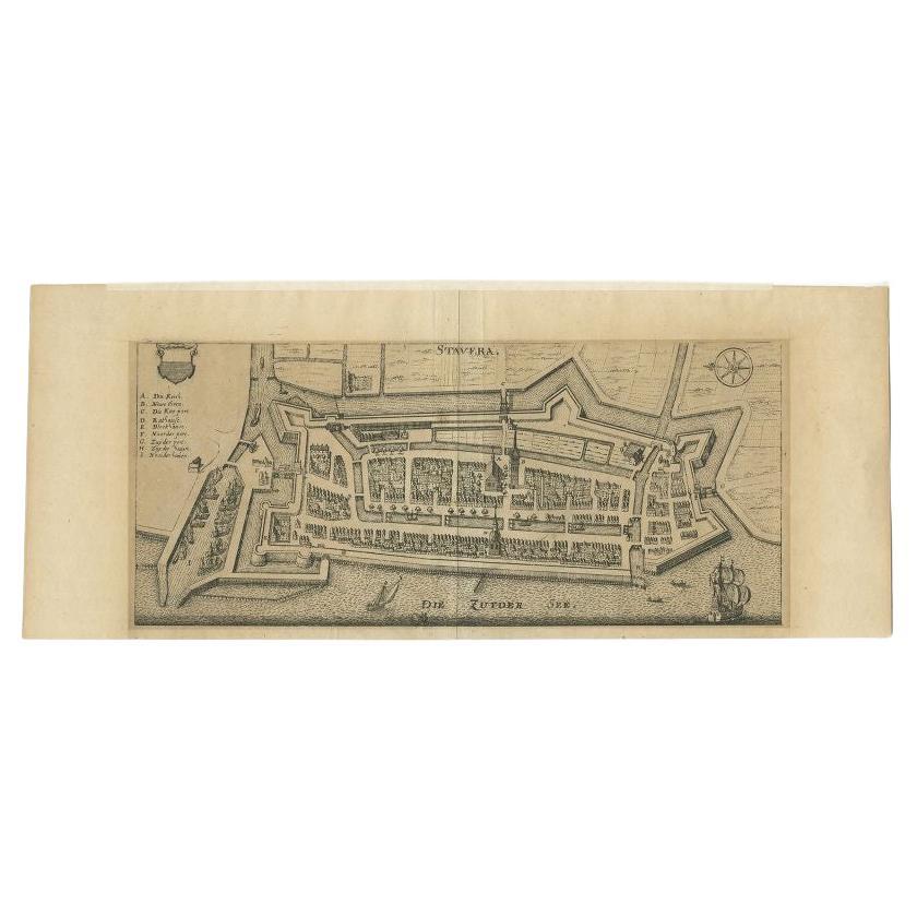
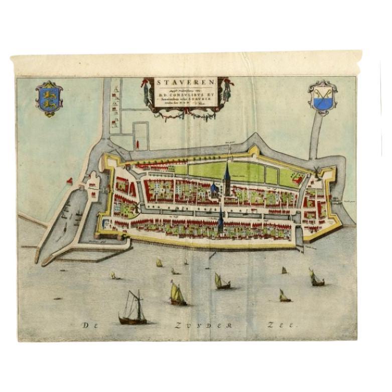
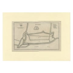
Antique Map of Stavoren by Merian, c.1650
About the Item
Antique map titled 'Stavera'. Map of the city of Stavoren, Friesland. With German legend. Trimmed, originally published on one sheet with a map of Bolsward and Hindeloopen. Artists and Engravers: Made after Braun & Hogenberg by M. Merian.
Artist: Made after Braun & Hogenberg by M. Merian.
Condition: Very good, general age-related toning. Passe-parout/matting included. Minor wear. Please study image carefully.
Date: c.1650
Overall size: 43.5 x 28 cm.
Antique prints have long been appreciated for both their aesthetic and investment value. They were the product of engraved, etched or lithographed plates. These plates were handmade out of wood or metal, which required an incredible level of skill, patience and craftsmanship. Whether you have a house with Victorian furniture or more contemporary decor an old engraving can enhance your living space. We offer a wide range of authentic antique prints for any budget.
- Dimensions:Height: 11.03 in (28 cm)Width: 17.13 in (43.5 cm)Depth: 0 in (0.01 mm)
- Materials and Techniques:
- Period:
- Date of Manufacture:circa 1650
- Condition:
- Seller Location:Langweer, NL
- Reference Number:
About the Seller
5.0
Platinum Seller
These expertly vetted sellers are 1stDibs' most experienced sellers and are rated highest by our customers.
Established in 2009
1stDibs seller since 2017
1,914 sales on 1stDibs
Typical response time: <1 hour
- ShippingRetrieving quote...Ships From: Langweer, Netherlands
- Return PolicyA return for this item may be initiated within 14 days of delivery.
More From This SellerView All
- Antique Map of Stavoren by Merian, c.1650Located in Langweer, NLAntique map titled 'Stavera'. Map of the city of Stavoren, Friesland. With German legend. Trimmed, originally published on one sheet with a map of Bolsward and Hindeloopen. Artists a...Category
Antique 17th Century Maps
MaterialsPaper
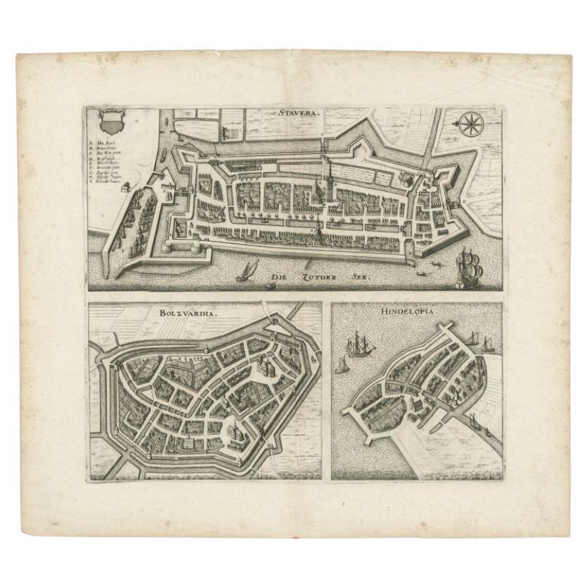
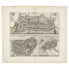
- Antique Map of Stavoren, Bolsward and Hindeloopen by Merian, c.1650Located in Langweer, NLAntique map titled 'Stavera, Bolzvardia, Hindelopia'. Three maps on one sheet depicting Stavoren, Bolsward and Hindeloopen (Friesland, The Netherlands). With German legend. Artists a...Category
Antique 17th Century Maps
MaterialsPaper
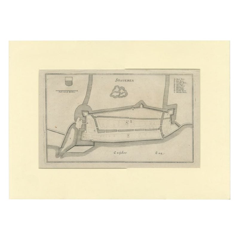
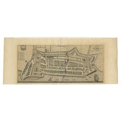
- Antique Map of the City of Stavoren by Merian, 1659Located in Langweer, NLAntique map titled 'Staveren'. Original antique map of the city of Stavoren, Friesland, the Netherlands. This map originates from 'Topographia Germania Inferioris' by C. Merian. Publ...Category
Antique 17th Century Maps
MaterialsPaper
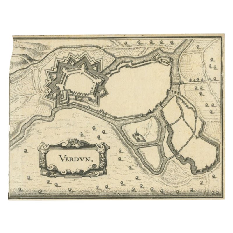
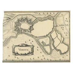
- Antique Map of the City of Verdun by Merian, c.1650Located in Langweer, NLAntique map titled 'Verdun'. Orginal antique map of Verdun, a small city in the Meuse department in Grand Est in northeastern France. This map originates from 'Topographia Germaniae'...Category
Antique 17th Century Maps
MaterialsPaper
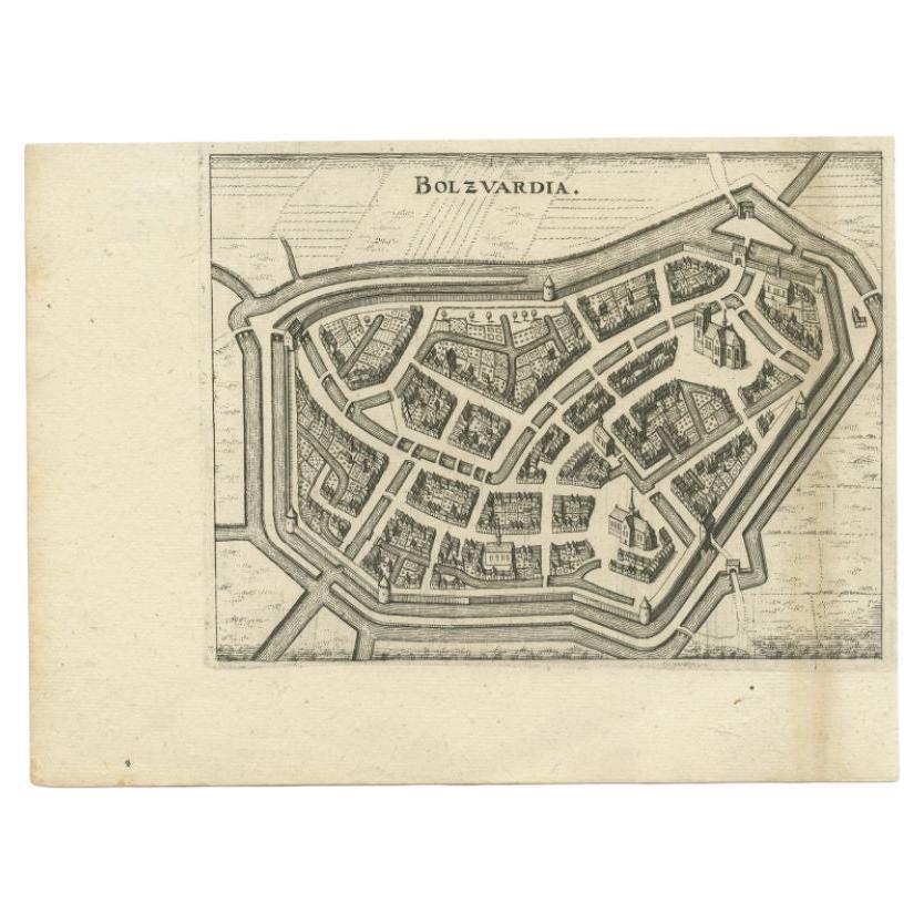
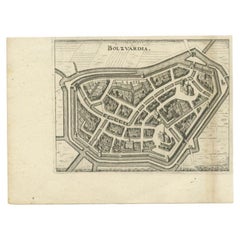
- Antique Map of the City of Bolsward by Merian, c.1650Located in Langweer, NLAntique map titled 'Bolzvardia'. Old map of the city of Bolsward, Friesland. This map was published with two other maps on one sheet (Hindeloopen and Stavoren). Artists and Engravers...Category
Antique 17th Century Maps
MaterialsPaper
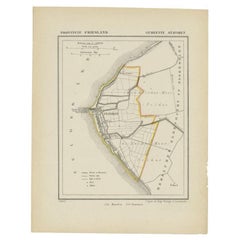
- Antique Map of Stavoren by Kuyper, 1868Located in Langweer, NLAntique map titled 'Provincie Friesland - Gemeente Stavoren'. Map of the township of Stavoren, Friesland. This map originates from 'Gemeente-Atlas van Nederland' by J. Kuyper. Artist...Category
Antique 19th Century Maps
MaterialsPaper
You May Also Like
- 1907 Map of Colorado, Antique Topographical Map, by Louis NellLocated in Colorado Springs, COThis highly detailed pocket map is a topographical map of the state of Colorado by Louis Nell from 1907. The map "has been complied from all availabl...Category
Antique Early 1900s American Maps
MaterialsPaper
- 1861 Topographical Map of the District of Columbia, by Boschke, Antique MapLocated in Colorado Springs, COPresented is an original map of Albert Boschke's extremely sought-after "Topographical Map of the District of Columbia Surveyed in the Years 1856 ...Category
Antique 1860s American Historical Memorabilia
MaterialsPaper
- Large Antique Polychromed Wood Statue of a Bishop, circa 1650Located in Dallas, TXThis 64 inch high antique statue of a Bishop dates to circa 1650 and is German in origin. Starting in the 15th and 16th centuries, there was a large demand for ecclesiastical carvings throughout central and western Europe. Large statues were commissioned for churches and smaller items were for private use. This bishop statue...Category
Antique 17th Century German Figurative Sculptures
MaterialsFabric, Glass, Wood, Paint
- Antique Map of Italy by Andriveau-Goujon, 1843By Andriveau-GoujonLocated in New York, NYAntique Map of Italy by Andriveau-Goujon, 1843. Map of Italy in two parts by Andriveau-Goujon for the Library of Prince Carini at Palazzo Carini i...Category
Antique 1840s French Maps
MaterialsLinen, Paper
- Antique Map of Principality of MonacoBy Antonio Vallardi EditoreLocated in Alessandria, PiemonteST/619 - "Old Geographical Atlas of Italy - Topographic map of ex-Principality of Monaco" - ediz Vallardi - Milano - A somewhat special edition ---Category
Antique Late 19th Century Italian Other Prints
MaterialsPaper
- 1864 Map of North America, Antique Hand-Colored Map, by Adolphe Hippolyte DufourLocated in Colorado Springs, COOffered is a map of North America entitled Amerique du Nord from 1864. This rare, separately published wall map was produced by Adolphe Hippolyte Dufour. This map includes vibrant an...Category
Antique 1860s French Maps
MaterialsPaper


Recently Viewed
View AllMore Ways To Browse
Antique German Decor
Lithograph City Maps
City Map Lithograph
Antique Merian Prints
Merian Engraving
Braun Germany
Hindeloopen Furniture
M Braun
Antique 16th Century Plates
Antique Caribbean Furniture
17th Century Plate Set
Antique Rose Compass
Antique Map Paint
Israeli Antique
Antique Maps Of North America
Tree Bag
North America Antique Map
Survey Map