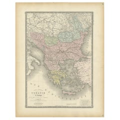
Antique Map of Turkey in Europe by Levasseur, '1875'
View Similar Items


Want more images or videos?
Request additional images or videos from the seller
1 of 5
Antique Map of Turkey in Europe by Levasseur, '1875'
About the Item
- Dimensions:Height: 24.02 in (61 cm)Width: 18.71 in (47.5 cm)Depth: 0.02 in (0.5 mm)
- Materials and Techniques:
- Period:
- Date of Manufacture:1875
- Condition:General age-related toning, minor wear. Few small holes, also affecting image. Original folding line, blank verso. Please study images carefully.
- Seller Location:Langweer, NL
- Reference Number:Seller: BG-12257-241stDibs: LU3054320208882
About the Seller
5.0
Platinum Seller
These expertly vetted sellers are 1stDibs' most experienced sellers and are rated highest by our customers.
Established in 2009
1stDibs seller since 2017
1,916 sales on 1stDibs
More From This SellerView All
- Antique Map of Europe by Levasseur, '1875'Located in Langweer, NLAntique map titled 'Carte générale de l'Europe'. Large map of Europe. This map originates from 'Atlas de Géographie Moderne Physique et Politique' by A. Levasseur. Published 1875.Category
Antique Late 19th Century Maps
MaterialsPaper
 $327 Sale Price40% Off
 - Antique Map of Russia in Europe by Levasseur, '1875'Located in Langweer, NLAntique map titled 'Carte générale de la Russie d'Europe (..)'. Large map of Russia in Europe. This map originates from 'Atlas de Géographie Moderne Physique et Politique' by A. Leva...Category
Antique Late 19th Century Maps
MaterialsPaper
- Antique Map of Oceania by Levasseur, '1875'Located in Langweer, NLAntique map titled 'Carte générale de l'Océanie'. Large map of Oceania. This map originates from 'Atlas de Géographie Moderne Physique et Politique' by A. Levasseur. Published 1875.Category
Antique Late 19th Century Maps
MaterialsPaper
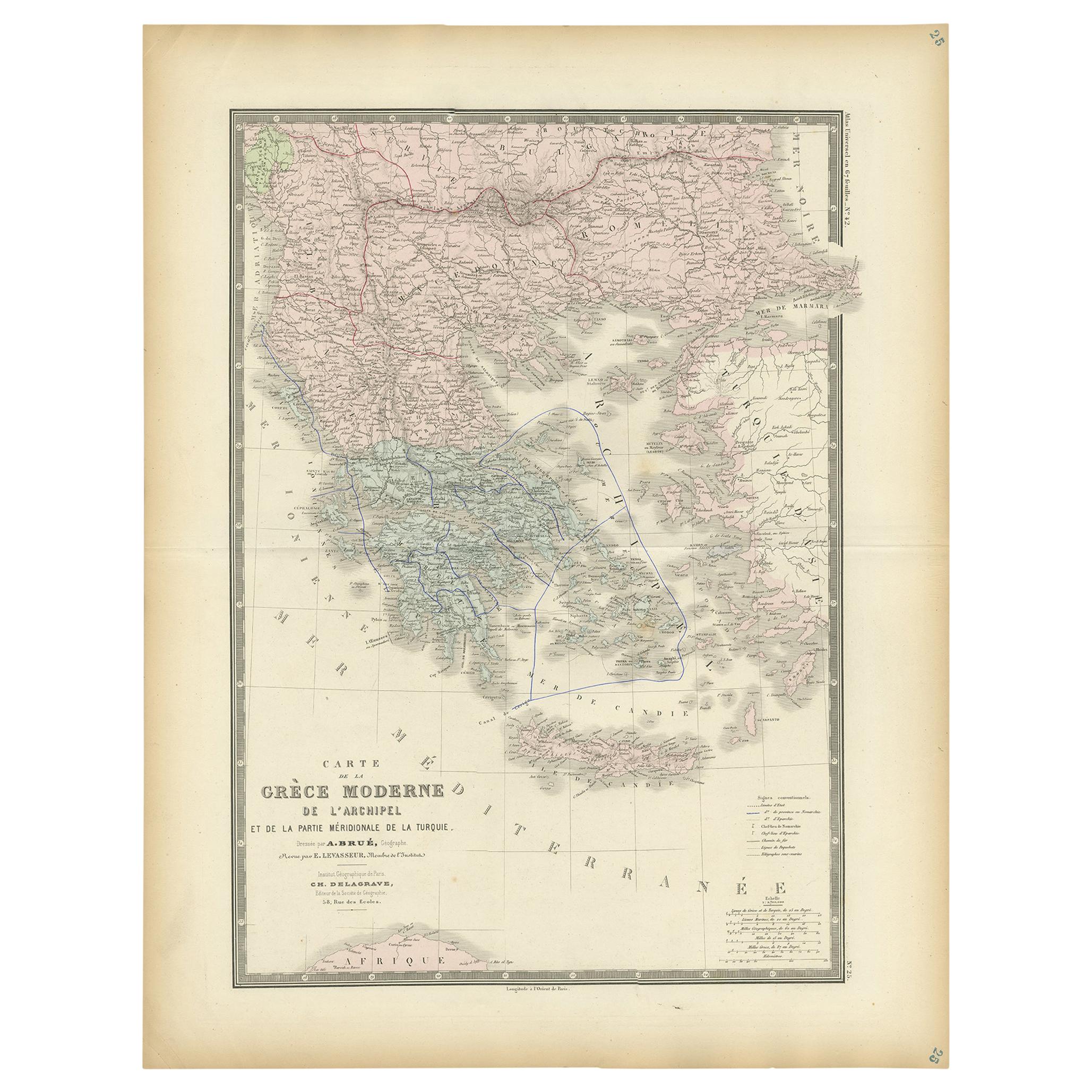
- Antique Map of Greece by Levasseur, '1875'Located in Langweer, NLAntique map titled 'Carte de la Grèce Modernde de l'Archipel'. Large map of Greece. This map originates from 'Atlas de Géographie Moderne Physique et Pol...Category
Antique Late 19th Century Maps
MaterialsPaper
 $409 Sale Price25% Off
 - Antique Map of Siberia by Levasseur '1875'Located in Langweer, NLAntique map titled 'Carte de la Russie d'Asie Sibérie'. Large map of Siberia. This map originates from 'Atlas de Géographie Moderne Physique et Politique' by A. Levasseur. Published ...Category
Antique Late 19th Century Maps
MaterialsPaper
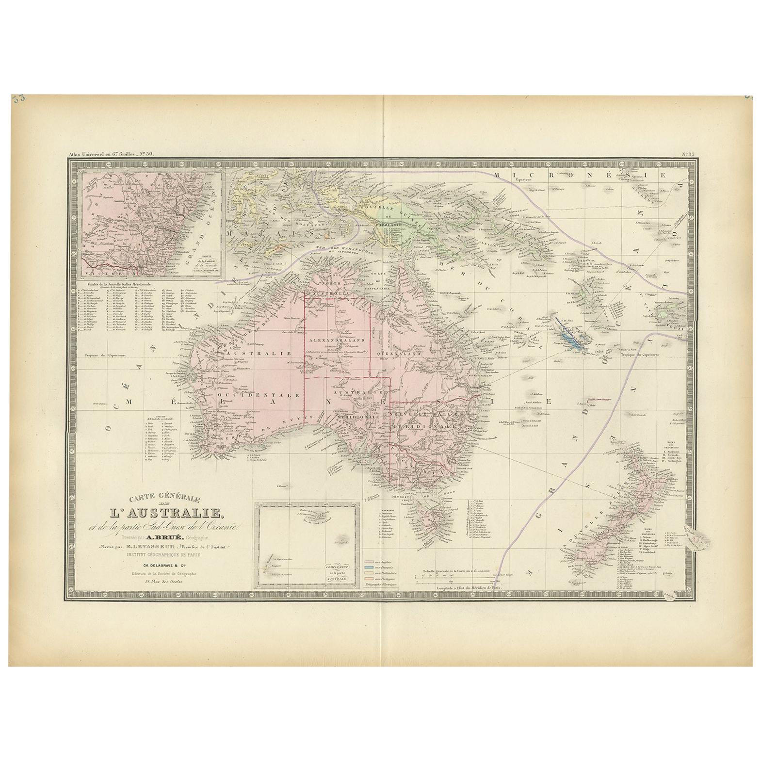
- Antique Map of Australia by Levasseur, '1875'Located in Langweer, NLAntique map titled 'Carte générale de l'Australie'. Large map of Australia. This map originates from 'Atlas de Géographie Moderne Physique et Politiq...Category
Antique Late 19th Century Maps
MaterialsPaper
 $382 Sale Price30% Off


You May Also Like
- Original Antique Map of Europe, Arrowsmith, 1820Located in St Annes, LancashireGreat map of Europe Drawn under the direction of Arrowsmith. Copper-plate engraving. Published by Longman, Hurst, Rees, Orme and Brown, 1820 ...Category
Antique 1820s English Maps
MaterialsPaper

- Antique Map of Italy by Andriveau-Goujon, 1843By Andriveau-GoujonLocated in New York, NYAntique Map of Italy by Andriveau-Goujon, 1843. Map of Italy in two parts by Andriveau-Goujon for the Library of Prince Carini at Palazzo Carini i...Category
Antique 1840s French Maps
MaterialsLinen, Paper
 $3,350 / set
 - Antique Map of Principality of MonacoBy Antonio Vallardi EditoreLocated in Alessandria, PiemonteST/619 - "Old Geographical Atlas of Italy - Topographic map of ex-Principality of Monaco" - ediz Vallardi - Milano - A somewhat special edition ---Category
Antique Late 19th Century Italian Other Prints
MaterialsPaper
 $227 Sale Price74% Off
 - Original Antique Map of Russia By Arrowsmith. 1820Located in St Annes, LancashireGreat map of Russia Drawn under the direction of Arrowsmith Copper-plate engraving Published by Longman, Hurst, Rees, Orme and Brown, 1820 Unframed.Category
Antique 1820s English Maps
MaterialsPaper

- Original Antique Map of China by Thomas Clerk, 1817Located in St Annes, LancashireGreat map of China Copper-plate engraving Drawn and engraved by Thomas Clerk, Edinburgh. Published by Mackenzie And Dent, 1817 Unframed.Category
Antique 1810s English Maps
MaterialsPaper

- Original Antique Map of Sweden, Engraved by Barlow, 1806Located in St Annes, LancashireGreat map of Sweden Copper-plate engraving by Barlow Published by Brightly & Kinnersly, Bungay, Suffolk. 1806 Unframed.Category
Antique Early 1800s English Maps
MaterialsPaper

Recently Viewed
View AllMore Ways To Browse
Antique In Europe
Map Europe
Maps Europe
Maps Of Europe
Map Of Europe
Large Antique Maps
Large Antique Map
Antique European Maps
Antique European Map
Antique Maps Europe Maps
Europe Map Antique
Antique Europe Map
Antique Maps Of Europe
Antique Map Europe
Antique Map Of Europe
Large 19th Century Maps
A La Carte
Turkish Map