Items Similar to Captain Cook's Exploration of Tahiti 18th C. Hand-Colored Map by Bellin


Want more images or videos?
Request additional images or videos from the seller
1 of 5
Captain Cook's Exploration of Tahiti 18th C. Hand-Colored Map by Bellin
About the Item
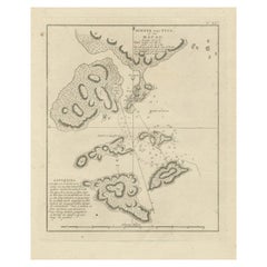
This beautiful 18th century hand-colored copper plate engraved map is entitled "Carte de l'Isle de Taiti, par le Lieutenant J. Cook" was created by Jacques Nicolas Bellin and published in 1780 in the French account of Captain James Cook's 1st voyage of exploration. It is the first detailed and accurate chart of Tahiti and it's neighboring island of Eimeo (now known as Moorea), depicting discoveries made by James Cook (still a Lieutenant in the British Royal Navy at the time of this voyage to Tahiti) during his first of three famous voyages of exploration which radically altered the knowledge of the world’s geography. Tahiti, the largest island of French Polynesia, is located in the archipelago of the Society Islands in the southern Pacific Ocean. The island consists of two roughly round portions with a central extinct volcano creating a mountain range and a series of radiating rivers. The map also includes the neighboring island of Eimeo, currently known as Moorea.
This beautifully hand-colored map is printed on chain-linked, laid paper with wide margins and two watermarks. The sheet measures 17.5" wide and 11.38" high. It has a central vertical fold, as issued. There is faint discoloration in the left upper corner, but it is otherwise in excellent condition.
Captain James Cook (1728 - 1779) was an English explorer, navigator and cartographer. Ultimately rising to the rank of Captain in the Royal Navy, Cook was the first to map Newfoundland prior to making his famous three voyages to the Pacific Ocean. Among his many achievements was the first European contact with the eastern coastline of Australia, the European discovery of the Hawaiian Islands, and the first recorded circumnavigation of New Zealand. Each of Cook’s voyages included scientists, cartographers and an artist to study and document the geography, the fauna and wildlife, as well as the culture of the inhabitants of the lands he visited.
In 1766 the Royal Society engaged Cook to travel to the Pacific Ocean to observe and record the transit of Venus across the sun. Cook, at the age of 39, was promoted to lieutenant and named as commander of the expedition by the British Admiralty. The expedition sailed from England on 26 August 1768, rounded Cape Horn and continued westward across the Pacific Ocean.
Arriving in Tahiti in April 1769 Cook anchored his ship, the Endeavour, in Matavai Bay on Tahiti's northwest coast, where he named a rocky promontory rising above the shoreline, Point Venus. It is here that he made his observations of the transit of Venus across the sun, fulfilling the initial mission of his voyage. He subsequently continued to explore the southern Pacific Ocean, including Australia, New Zealand, New Guinea and Tasmania, etc., which was the main goal of his voyage.
During his stay on the island, Cook charted Tahiti's coast which took him 5 days in a pinnace (a small boat brought for local exploration), and as this chart taken from his original sketches shows, he saw wooded and fertile regions, hills, and many thickly settled coastal communities as well as coral reefs ringing the islands.
The cartographer was Jacques Nicolas Bellin (1703-1772), a French hydrographer, geographer, and member of the French intellectual group the Philosophes. Bellin was born in Paris. He was hydrographer of France's hydrographic office, member of the Académie de Marine and of the Royal Society of London. Over a 50 year career, he produced a large number of maps of particular interest to the Ministère de la Marine. His maps of Canada and of French territories in North America (New France, Acadia, Louisiana) are particularly valuable. He died at Versailles. The map was engraved by Robert Benard, a well-known French engraver, for inclusion in the official French edition of Cook's Voyages.
- Creator:Jacques-Nicolas Bellin (Artist)
- Dimensions:Height: 11.38 in (28.91 cm)Width: 17.5 in (44.45 cm)Depth: 0.13 in (3.31 mm)
- Materials and Techniques:Paper,Engraved
- Place of Origin:
- Period:
- Date of Manufacture:1780
- Condition:Wear consistent with age and use.
- Seller Location:Alamo, CA
- Reference Number:
About the Seller
5.0
Vetted Seller
These experienced sellers undergo a comprehensive evaluation by our team of in-house experts.
1stDibs seller since 2020
12 sales on 1stDibs
- ShippingRetrieving quote...Ships From: Alamo, CA
- Return PolicyA return for this item may be initiated within 7 days of delivery.
More From This SellerView All
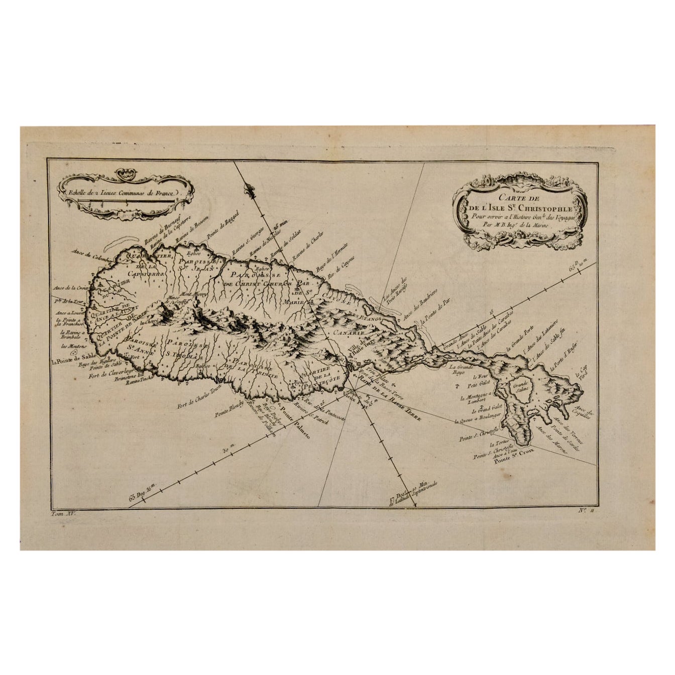
- St. Christophe 'St. Kitts' Island: An 18th Century Hand-colored Map by BellinBy Jacques-Nicolas BellinLocated in Alamo, CAJacques Bellin's copper-plate map of the Caribbean island of Saint Kitts entitled "Carte De De l'Isle St. Christophe Pour servir á l'Histoire Genle. des V...Category
Antique Mid-18th Century French Maps
MaterialsPaper
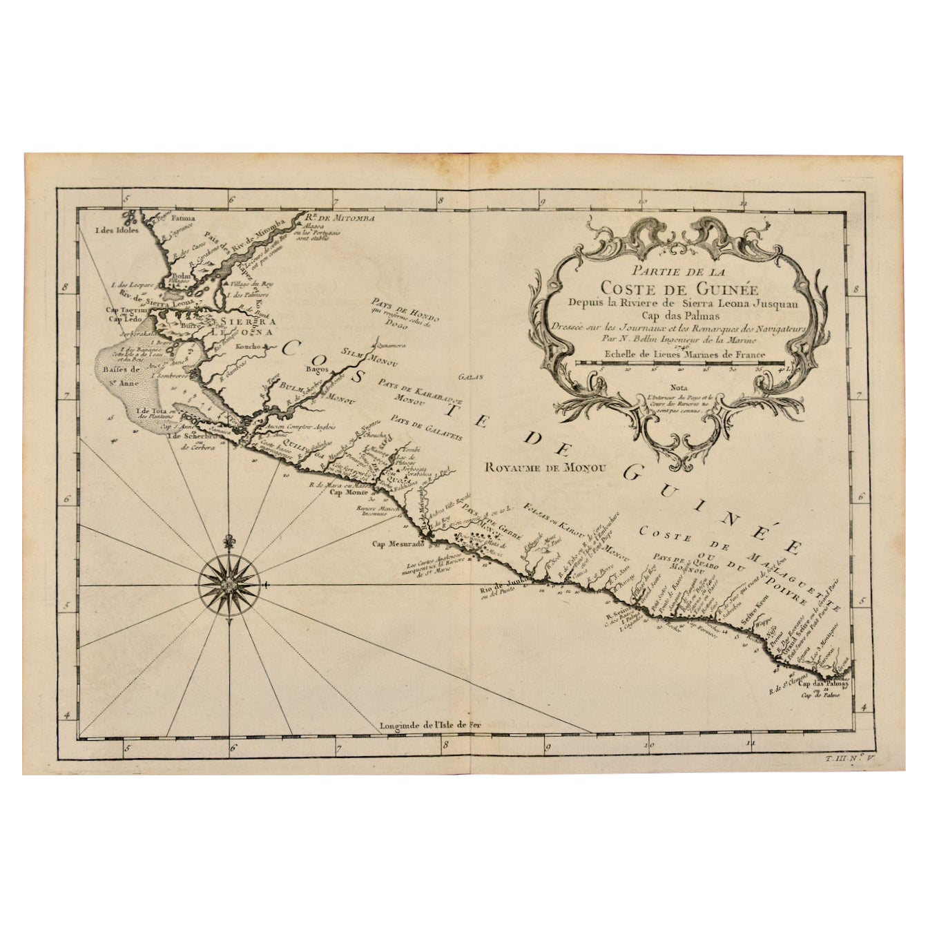
- West Coast of Africa, Guinea & Sierra Leone: An 18th Century Map by BellinBy Jacques-Nicolas BellinLocated in Alamo, CAJacques Bellin's copper-plate map entitled "Partie de la Coste de Guinee Dupuis la Riviere de Sierra Leona Jusquau Cap das Palmas", depicting the coast of Guinea and Sierra Leone in ...Category
Antique Mid-18th Century French Maps
MaterialsPaper
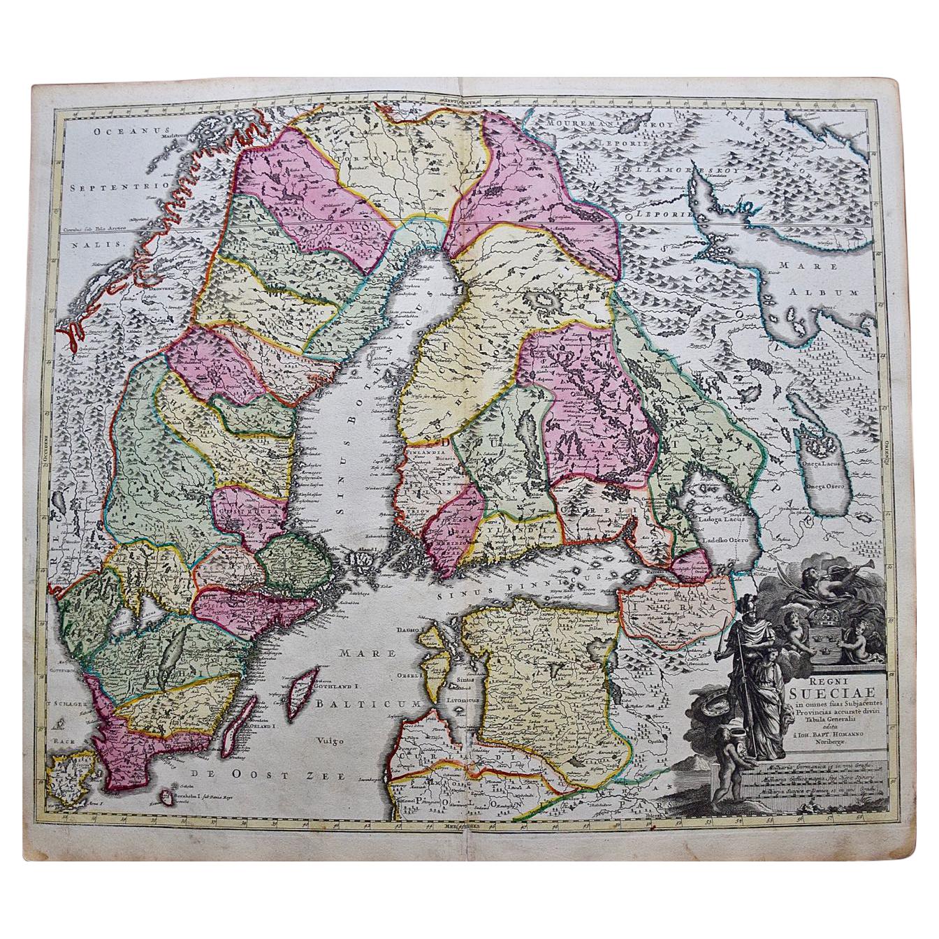
- Sweden & Adjacent Portions of Scandinavia: A Hand-Colored 18th C. Map by HomannBy Johann Baptist HomannLocated in Alamo, CAThis hand-colored map of Sweden and adjacent portions of Scandinavia entitled "Regni Sueciae in Omnes suas Subjacentes Provincias accurate divisi Tabula Generalis" was created by Joh...Category
Antique 1720s German Maps
MaterialsPaper
- 18th Century Hand Colored Map of Spain and Portugal by VisscherBy Nicolaes Visscher IILocated in Alamo, CAThis is an early 18th century map of Spain and Portugal, with attractive original hand-coloring, entitled "Hispaniae et Portugalliae Regna per Nicolaum Visscher cum Privilegio Ordinu...Category
Antique Early 18th Century Dutch Maps
MaterialsPaper
- Scandinavia & Portions of Eastern Europe: 18th Century Hand-Colored Homann MapBy Johann Baptist HomannLocated in Alamo, CAAn early 18th century hand-colored copper-plate map entitled "Regni Sueciae in omnes suas Subjacentes Provincias accurate divisi Tabula Generalis" by Johann Baptist Homann (1663-1724...Category
Antique Early 18th Century German Maps
MaterialsPaper
- Germany West of the Rhine: A Hand-colored 18th Century Map by de WitBy Frederick de WitLocated in Alamo, CAThis original 18th century hand-colored map of the county of Moers, Germany entitled "Illustrissimo Celsissmo Principi GUILIELMO HENRICO D.G. Arausionum Principi Domino suo Clementis...Category
Antique Early 18th Century Dutch Maps
MaterialsPaper


You May Also Like
- Antique Map of Cook's Strait in New Zealand, 1803Located in Langweer, NLAntique map New Zealand titled 'Kaart van Cooks Straat in Nieuw Zeeland'. Antique map of Cook's Strait in New Zealand. Originates from 'Reizen ...Category
Antique 19th Century Maps
MaterialsPaper
- Antique Map of Celebes 'Sulawesi, Indonesia' by Bellin, ciarca 1755By Jacques-Nicolas BellinLocated in Langweer, NLAntique map titled 'Carte de l'Isle Celebes ou Macassar'. Map of Celebes (Sulawesi, Indonesia), showing Makassar, which was the most important trading city of eastern Indonesia in th...Category
Antique Mid-18th Century European Maps
MaterialsPaper
- Antique Map of Tartary and Northeast Asia by Bellin, circa 1750By Jacques-Nicolas BellinLocated in Langweer, NLAntique map titled 'Carte de la Tartarie Occidentale'. Map of Tartary and northeast Asia, from Lake Baykal, Partie du Siberia in the north, Pays des Kalkas at the center, as well as ...Category
Antique Mid-18th Century European Maps
MaterialsPaper
- Antique Map of Macao and Surroundings by Captain Cook, 1803Located in Langweer, NLAntique map Macao titled 'Schets van Typa of van Macao'. Map of Macao and surrounding islands. Originates from 'Reizen Rondom de Waereld door James Cook (..)'. Artists and Engravers:...Category
Antique 19th Century Maps
MaterialsPaper
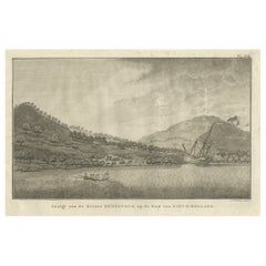
- Captain Cook's Encampment in Australia where The Endeavour was Beached, 1803Located in Langweer, NLAntique print Australia titled 'Gezigt van de Rivier Endeavour op de Kust van Nieuw-Holland'. View of an encampent on the shore of the Endeavour river on the coast of Australia where the Endeavour boat was beached. Originates from 'Reizen Rondom de Waereld door James Cook (..)'. HMS Endeavour was a British Royal Navy research vessel that Lieutenant James Cook commanded to Australia and New Zealand on his first voyage of discovery from 1768 to 1771. She was launched in 1764 as the collier Earl of Pembroke, with the Navy purchasing her in 1768 for a scientific mission to the Pacific Ocean and to explore the seas for the surmised Terra Australis Incognita or "unknown southern land". Commissioned as His Majesty's Bark Endeavour, she departed Plymouth in August 1768, rounded Cape Horn and reached Tahiti in time to observe the 1769 transit of Venus across the Sun. She then set sail into the largely uncharted ocean to the south, stopping at the islands of Huahine, Bora Bora, and Raiatea west of Tahiti to allow Cook to claim them for Great Britain. In September 1769, she anchored off New Zealand, becoming the first European vessel to reach the islands since Abel Tasman's Heemskerck 127 years earlier. In April 1770, Endeavour became the first European ship to reach the east coast of Australia, with Cook going ashore at what is now known as Botany Bay. Endeavour then sailed north along the Australian coast. She narrowly avoided disaster after running aground on the Great Barrier Reef, and Cook had to throw her guns overboard to lighten her. Endeavour was beached on the Australian mainland for seven weeks to permit rudimentary repairs to her hull. Resuming her voyage, she limped into port in Batavia in October 1770, her crew sworn to secrecy about the lands that they had visited. From Batavia Endeavour continued westward, rounded the Cape of Good Hope on 13 March 1771 and reached the English port of Dover on 12 July, having been at sea for nearly three years. The ship was largely forgotten after her Pacific voyage, spending the next three years hauling troops and cargo to and from the Falkland Islands. She was renamed in 1775 after being sold into private hands, and used to transport timber from the Baltic. Rehired as a British troop transport during the American War of Independence, she was finally scuttled in a blockade of Narragansett Bay, Rhode Island in 1778. Historical evidence indicates the ship was sunk just north of Goat Island in Newport Harbor, along with four other British transports. Relics from Endeavour are displayed at maritime museums worldwide, including an anchor and six of her cannon. A replica of Endeavour was launched in 1994 and is berthed alongside the Australian National Maritime Museum in Sydney Harbour. The NASA Space Shuttle...Category
Antique Early 1800s Prints
MaterialsPaper
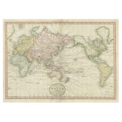
- Very Attractive Antique Map of the World as Planisphere, Shows Cook's VoyagesLocated in Langweer, NLAntique map titled 'Chart of the World, according to Mercators Projection'. This world map shows the various discoveries of Captain James Cook during his 3 voyages between 1768 and 1780, and the English and French Explorers who followed immediately thereafter, including Vancouver and La Perouse. This edition of the map is significantly revised from the editions issued immediately after the official report of Cook's Voyages were integrated into the map, showing better detail in New Zealand, Australia, the Northwest Coast of America and North East coast of Asia, along with Greenland. A new large lake also appears for the first time in the Western part of North America, shortly before the commencement of the Lewis...Category
Antique Late 18th Century Maps
MaterialsPaper


Recently Viewed
View AllMore Ways To Browse
French Copper 18th
Antique Hand Saws
Southern Pacific
Southern New And Used Furniture
Ship Captain
18th C American
Antique Boats Of America
18th C American Furniture
Coral Colored Furniture
French Map Of America
Used Furniture Louisiana
18th Century Sketch
18th C Copper
Antique Ship Anchor Anchors
Antique Ship Anchor
Antique Ship Anchors
Antique Ships Anchor
Louisiana Furniture