Items Similar to Edinburgh, Scotland Coast: A 17th Century Hand-Colored Sea Chart by Collins


Want more images or videos?
Request additional images or videos from the seller
1 of 6
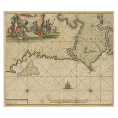
Edinburgh, Scotland Coast: A 17th Century Hand-Colored Sea Chart by Collins
About the Item
This hand-colored sea chart is entitled "Edinburgh Firth" from "Great Britain's Coasting Pilot. Being a New and Exact Survey of the Sea-Coast of England" by Captain Greenville Collins, first published in 1693. It depicts the city of Edinburgh, Scotland with its castle and abbey and adjacent waterways, as well as St. Andrews and Dunbar, Scotland. It includes a compass rose, a sailing ship and multiple rhumb lines, as well as depth markings along the coast. The beautiful and colorful cartouche is enhanced by multiple spears, guns, cannons, flags, sea birds, fish, two mermaids, a coat of arms and a crown. It includes a dedication to James Earle of Perth, Lord Chancellor of Scotland.
These sea charts by Captain Greenvile Collins (1643-1694) are beautiful, colorful and striking, as well as historically very important to the British navy for approximately 100 years. Captain Collins was appointed “His Majesty’s Hydrographer” by King Charles II and asked to survey the coast of Great Britain and plot all of the harbors, rivers and islands, etc. This took seven years and the resulting charts were first published in 1693. They were published until 1792.
We have 16 sea charts from this series that are all the same size and are framed and matted identically. The frames are a unique plexiglass sleeve design, measuring: 27.75" x 23" x 0.5" and the mats are a cream color. There is a horizontal fold, a vertical crease on the right and tiny spots in the upper chart. It is otherwise in excellent condition.
The provenance for these sea charts is very interesting. They were owned by Tom Perkins, who is considered one of the fathers of Silicon Valley. He was one of the founders of Kleiner Perkins Cauffield and Byers, the first big and most influential Silicon Valley venture capital company. Perkins himself was an avid sailor and had at the time the largest and most technologically advanced sailing yacht in the world, the Maltese Falcon.
- Creator:Captain Greenvile Collins (Artist)
- Dimensions:Height: 23 in (58.42 cm)Width: 27.75 in (70.49 cm)Depth: 0.5 in (1.27 cm)
- Materials and Techniques:Paper,Engraved
- Place of Origin:
- Period:Late 17th Century
- Date of Manufacture:1693
- Condition:Wear consistent with age and use.
- Seller Location:Alamo, CA
- Reference Number:
About the Seller
5.0
Vetted Seller
These experienced sellers undergo a comprehensive evaluation by our team of in-house experts.
1stDibs seller since 2020
12 sales on 1stDibs
- ShippingRetrieving quote...Ships From: Alamo, CA
- Return PolicyA return for this item may be initiated within 7 days of delivery.
More From This SellerView All
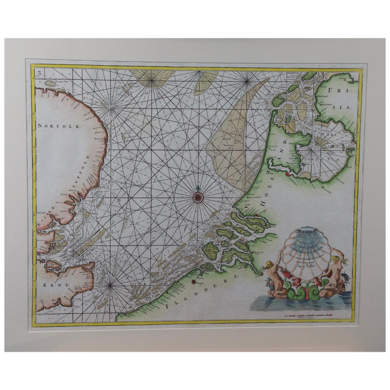
- Flanders, Holland & Norfolk: Hand-Colored 17th Century Sea Chart by CollinsBy Captain Greenvile CollinsLocated in Alamo, CAThis hand-colored chart of the seas about Flanders, Holland, Frisia, and Norfolk is from "Great Britain's Coasting Pilot. Being a New and Exact Survey of the Sea-Coast of England" by...Category
Antique Late 17th Century English Maps
MaterialsPaper
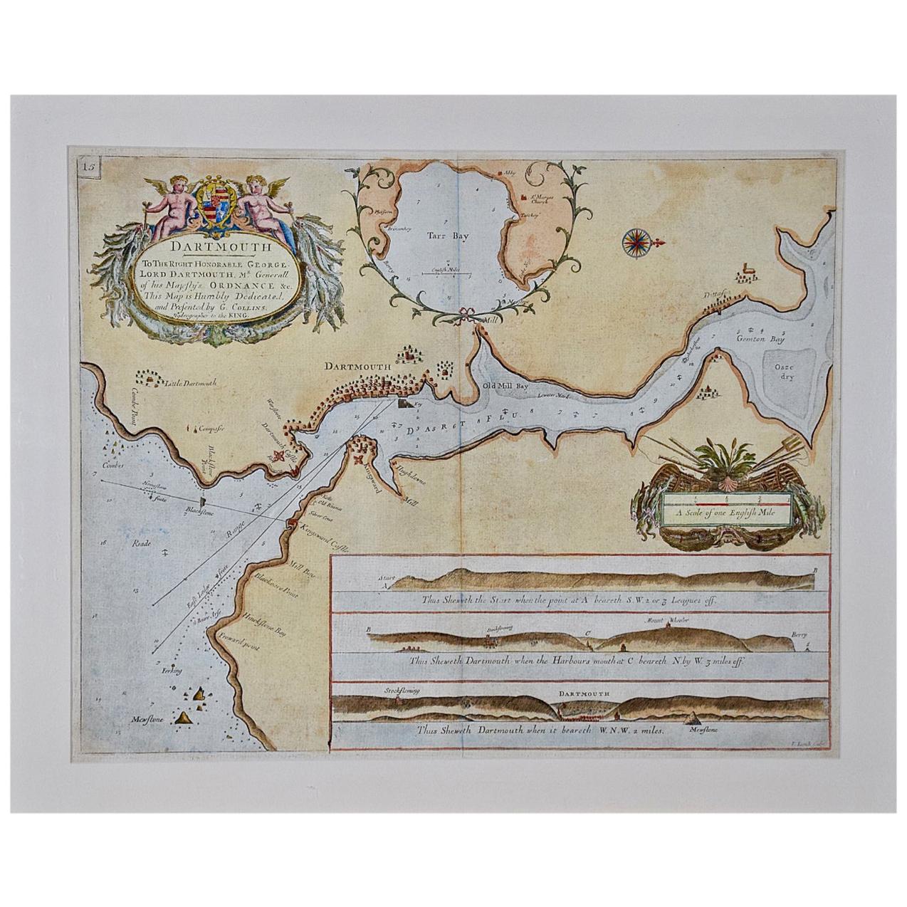
- Dartmouth, England: A Hand-Colored 17th Century Sea Chart by Captain CollinsBy Captain Greenvile CollinsLocated in Alamo, CAThis hand-colored sea chart of the area around Dartmouth, England is from "Great Britain's Coasting Pilot. Being a New and Exact Survey of the Sea-Coast of England", first published ...Category
Antique Late 17th Century English Maps
MaterialsPaper
- Plymouth, England: A Hand-Colored 17th Century Sea Chart by Captain CollinsBy Captain Greenvile CollinsLocated in Alamo, CAThis hand-colored sea chart of the area around Plymouth, England from "Great Britain's Coasting Pilot. Being a New and Exact Survey of the Sea-Coast of England", first published in 1...Category
Antique Late 17th Century English Maps
MaterialsPaper
- Northern Scotland: A 17th Century Hand-colored Map by MercatorBy Gerard MercatorLocated in Alamo, CAThis is a framed hand-colored 17th century map of Northern Scotland by Gerard Mercator entitled "Scotiae pars Septentrionalis", published in Amsterdam in 1636. It is a highly detailed map of the northern part of Scotland, with the northwest Highlands and the cities Inverness and Aberdeen, as well as the Orkney Islands and the Hebrides. There is a decorative title cartouche in the upper left corner. The map is presented in an antiqued brown wood...Category
Antique 1630s Dutch Maps
MaterialsPaper
- "Africa Vetus": a 17th Century Hand-Colored Map by SansonBy Nicolas SansonLocated in Alamo, CAThis original hand-colored copperplate engraved map of Africa entitled "Africa Vetus, Nicolai Sanson Christianiss Galliar Regis Geographi" was originally created by Nicholas Sanson d...Category
Antique Late 17th Century French Maps
MaterialsPaper
- Greece, "Graeciae Antiquae"" A 17th Century Hand-colored Map by SansonBy Nicolas SansonLocated in Alamo, CAThis is an original 17th century hand colored copperplate engraved map of Greece entitled "Graeciae Antiquae Tabula Hanc Geographicam" by Nicolas d'Abbeville Sanson, engraved and pub...Category
Antique Mid-17th Century French Maps
MaterialsPaper


You May Also Like
- Antique Chart of Dundee, Aberdeen and Montrose in Scotland, C.1774By Captain Greenvile CollinsLocated in Langweer, NLAntique map titled 'To the Honble the Magistrates of the Citty of Aberdeene'. Sea chart of Tay Estuary depictinging Dundee, with two further inset charts of Aberdeen and Montrose, wi...Category
Antique 18th Century Maps
MaterialsPaper
- Atlas Minor Du Monde World Geography 1695 17th Century in Hand ColoredBy Pierre MortierLocated in Diest, Vlaams BrabantWorld Atlas Minor world107 detailed maps and overviews Hand colored 17th century, dated 1695 Complete with minor and old original paper restoration.Category
Antique 17th Century Dutch Renaissance Books
MaterialsPaper
- Antique Sea Chart of the Western Coast of AfricaLocated in Langweer, NLAntique map titled 'Nieuwe Paskaert van de Kust van Genehoa (..)'. This attractive sea chart covers the western coast of Africa from Cape Blanco (Ras Nouadhibou) to Cape Verde (Dakar...Category
Antique Late 17th Century Maps
MaterialsPaper
- 17th. Century ViolinLocated in Perth, GB17th century violin possibly Italian. Dendrochronology says some of the timber is 17th century. There is good voulme, resonance and and tone. We would be happy to send you a recordin...Category
Antique 17th Century Musical Instruments
MaterialsWood
- Early 17th Century SculptureLocated in Copenhagen, KAmazing Baroque sculpture of a woman wearing a crown in original paint. Her hands are missing. Colors are untouched, recently cleaned off from a thick dark coating, I have images fro...Category
Antique Early 17th Century French Baroque Figurative Sculptures
MaterialsOak
- Monumental 17th Century AngelLocated in Madrid, ESMajestuous 17th century Angel. Important carved, gilded and polychrome wooden angel from the 17th century from the choir of a church in Spain. It is of very good quality (see the dr...Category
Antique Late 17th Century Figurative Sculptures
MaterialsFruitwood
Recently Viewed
View AllMore Ways To Browse
Engraved Crown
Antique Cream Color
Antique Cream Colour
Used Furniture Edinburgh
British Navy
Antique Furniture Edinburgh
Antique Edinburgh Scotland
17th King
Ship Captain
Antique Furniture In Edinburgh
17th Century Ship
Map Chart
Ship Map
Scotland Castles
Scottish Castle
Sea Captain
Hand Compass
Used Office Furniture Edinburgh