Items Similar to Map of the Island of Mindanao and the Sulu Archipelago – 1899

Want more images or videos?
Request additional images or videos from the seller
1 of 9
Map of the Island of Mindanao and the Sulu Archipelago – 1899
$520.32
£395.53
€440
CA$731.23
A$795.10
CHF 418.94
MX$9,658.22
NOK 5,266.96
SEK 4,937.35
DKK 3,367.85
About the Item
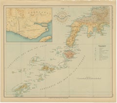
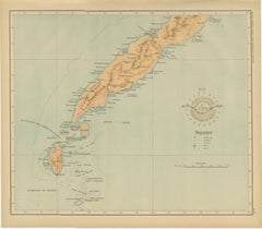
Map of Batanes and Babuyan Islands – *Observatorio de Manila*, 1899
An original late-19th-century scientific map of the Batanes and Babuyan island groups, situated north of Luzon, published by the Observatorio de Manila in 1899. This map, issued under the Islas Filipinas – Observaciones Meteorológicas y Sismológicas series, reflects the meticulous cartographic and geophysical work carried out at the Manila Observatory during the final years of Spanish administration and the early American period in the Philippines.
The engraving details the northernmost islands of the Philippine archipelago, including Batan, Sabtang, Itbayat, and Calayan, extending to the Babuyan Channel and the northern coast of Luzon. An inset map of the Palaui area near Cape Engaño provides additional topographical reference. The map’s fine lithographic shading conveys relief and coastal contours with precision, while the Observatory’s embossed seal, “Observatorio de Manila – Islas Filipinas,” authenticates the plate.
The Observatorio de Manila, founded in 1865 by the Jesuits, became the leading meteorological and seismological institution in Asia, producing some of the most accurate scientific maps of the region. These maps were later incorporated into the United States Coast and Geodetic Survey after the turn of the century, marking a transition between colonial scientific traditions.
This sheet represents a significant document of early Philippine scientific cartography and offers a rare glimpse of the islands before the widespread influence of modern mapping methods.
Condition report:
Excellent impression with crisp detail and original color tones. Slight toning to margins and minor handling consistent with age. Embossed seal of the Observatorio clearly visible.
Framing tips:
An elegant historical map that pairs well with a warm ivory mat and a dark wooden or black frame. A thin gilt border enhances the subtle coloring and gives depth to the presentation.
Technique: Lithograph on paper
Maker: Observatorio de Manila, Philippines, 1899
- Dimensions:Height: 12.8 in (32.5 cm)Width: 14.57 in (37 cm)Depth: 0.01 in (0.2 mm)
- Materials and Techniques:
- Place of Origin:
- Period:
- Date of Manufacture:1899
- Condition:Excellent impression with crisp detail and original color tones. Slight toning to margins and minor handling consistent with age. Embossed seal of the Observatorio clearly visible.
- Seller Location:Langweer, NL
- Reference Number:Seller: BG-12176-261stDibs: LU3054346962392
About the Seller
5.0
Recognized Seller
These prestigious sellers are industry leaders and represent the highest echelon for item quality and design.
Platinum Seller
Premium sellers with a 4.7+ rating and 24-hour response times
Established in 2009
1stDibs seller since 2017
2,696 sales on 1stDibs
Typical response time: <1 hour
- ShippingRetrieving quote...Shipping from: Langweer, Netherlands
- Return Policy
Authenticity Guarantee
In the unlikely event there’s an issue with an item’s authenticity, contact us within 1 year for a full refund. DetailsMoney-Back Guarantee
If your item is not as described, is damaged in transit, or does not arrive, contact us within 7 days for a full refund. Details24-Hour Cancellation
You have a 24-hour grace period in which to reconsider your purchase, with no questions asked.Vetted Professional Sellers
Our world-class sellers must adhere to strict standards for service and quality, maintaining the integrity of our listings.Price-Match Guarantee
If you find that a seller listed the same item for a lower price elsewhere, we’ll match it.Trusted Global Delivery
Our best-in-class carrier network provides specialized shipping options worldwide, including custom delivery.More From This Seller
View AllMap of Western Mindanao and the Sulu Archipelago – Observatorio de Manila, 1899
Located in Langweer, NL
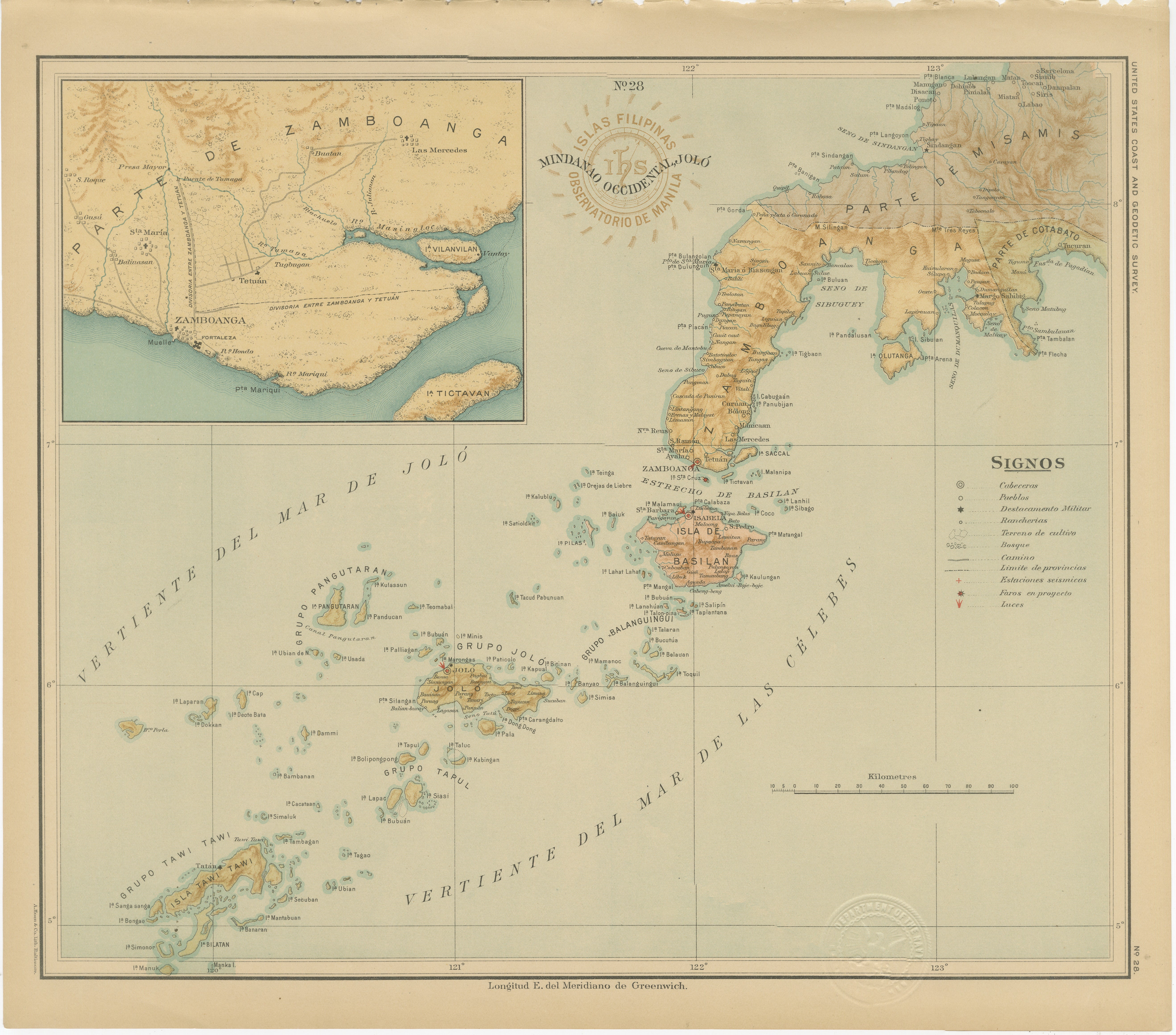
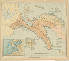
Map of Western Mindanao and the Sulu Archipelago – Observatorio de Manila, 1899
This original chromolithographed map titled “Islas Filipinas – Mindanao Occidental y Joló” (Plate No....
Category
Antique 1890s Philippine Maps
Materials
Paper
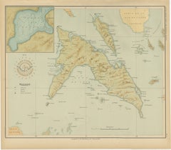
Map of Polillo Islands and Eastern Luzon Coast – Observatorio de Manila, 1899
Located in Langweer, NL
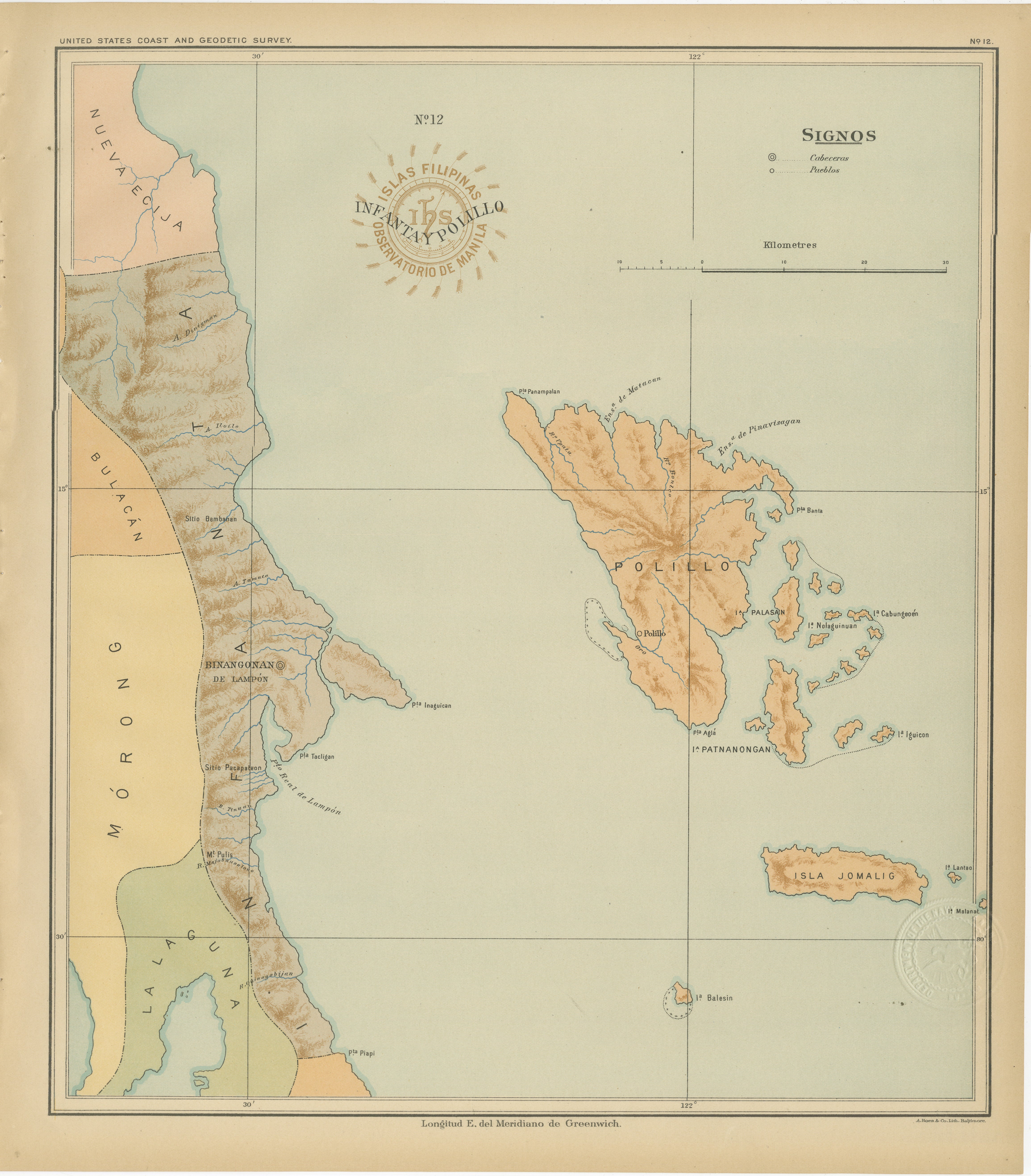
Map of Polillo Islands and Eastern Luzon Coast – Observatorio de Manila, 1899
This chromolithographed map titled “Islas Filipinas – Infanta y Polillo” was created in 1899 under the ...
Category
Antique 1890s Philippine Maps
Materials
Paper
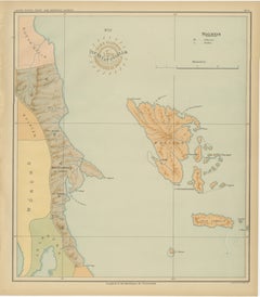
Map of Masbate and Ticao Islands – Observatorio de Manila, 1899
Located in Langweer, NL
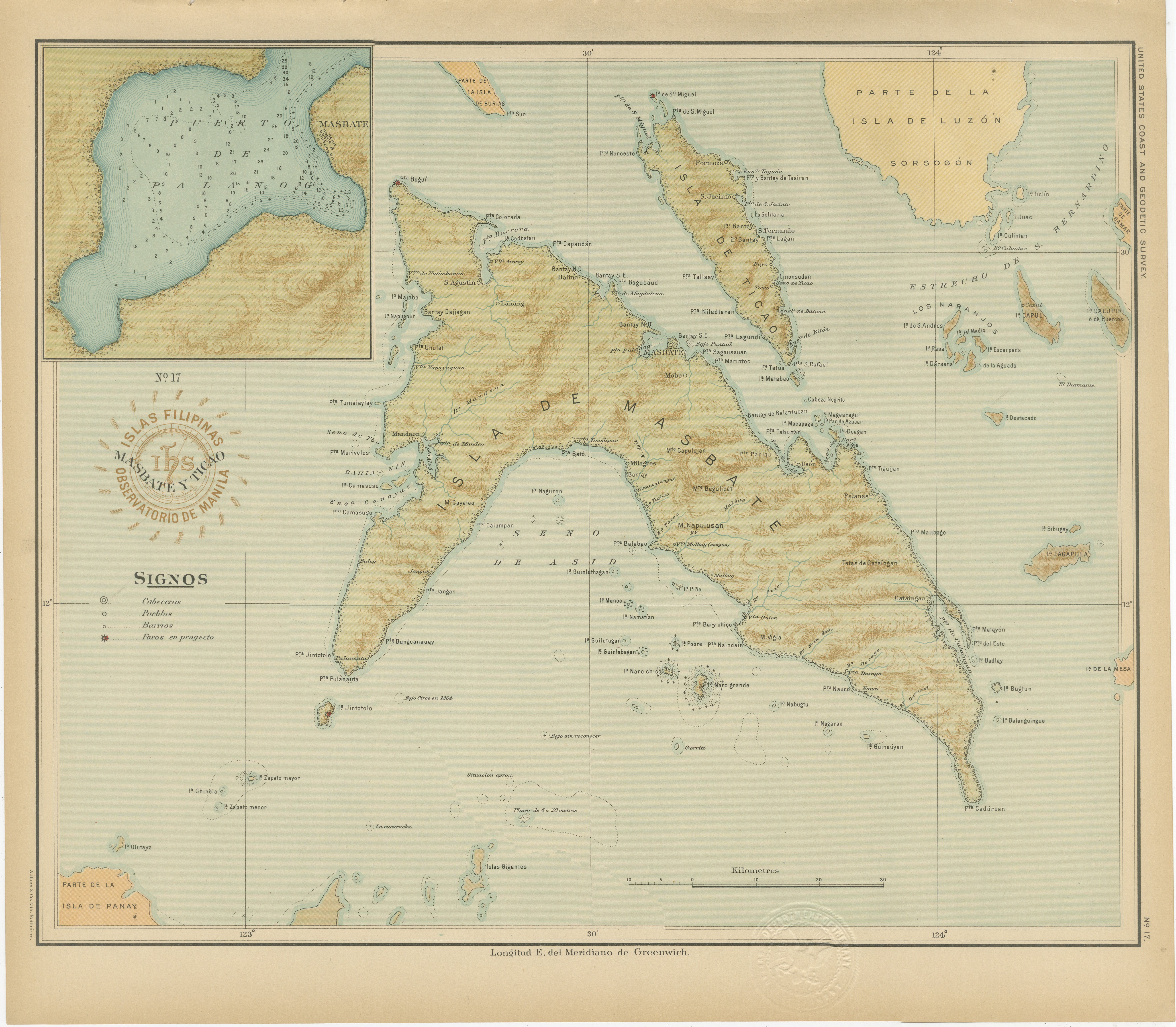
Map of Masbate and Ticao Islands – Observatorio de Manila, 1899
This elegant chromolithographed map titled “Islas Filipinas – Masbate y Ticao” was created under the supervision of R...
Category
Antique 1890s Philippine Maps
Materials
Paper
Map of Southern Luzon and Camarines Provinces – Observatorio de Manila, 1899
Located in Langweer, NL
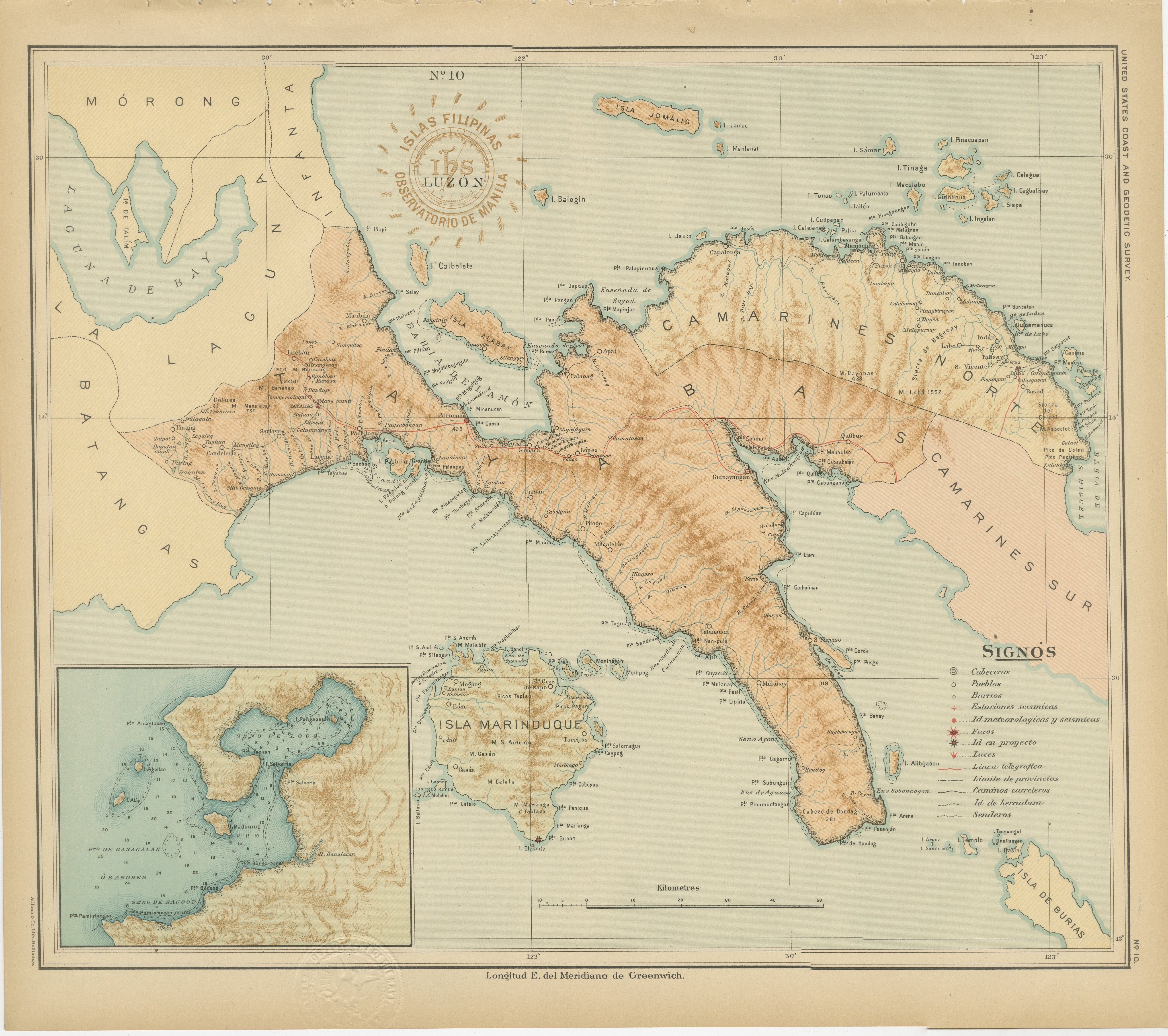
Title: Map of Southern Luzon and Camarines Provinces – Observatorio de Manila, 1899
Description:
This chromolithographed map titled “Islas Filipinas – Luzón” was published in 1899 u...
Category
Antique 1890s Philippine Maps
Materials
Paper
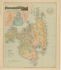
Map of Eastern Mindanao with Mount Apo – Observatorio de Manila, 1899
Located in Langweer, NL
Map of Eastern Mindanao with Mount Apo – Observatorio de Manila, 1899
This original chromolithograph titled “Islas Filipinas – Mindanao Oriental” (Plate No. 27) was created under th...
Category
Antique 1890s Philippine Maps
Materials
Paper
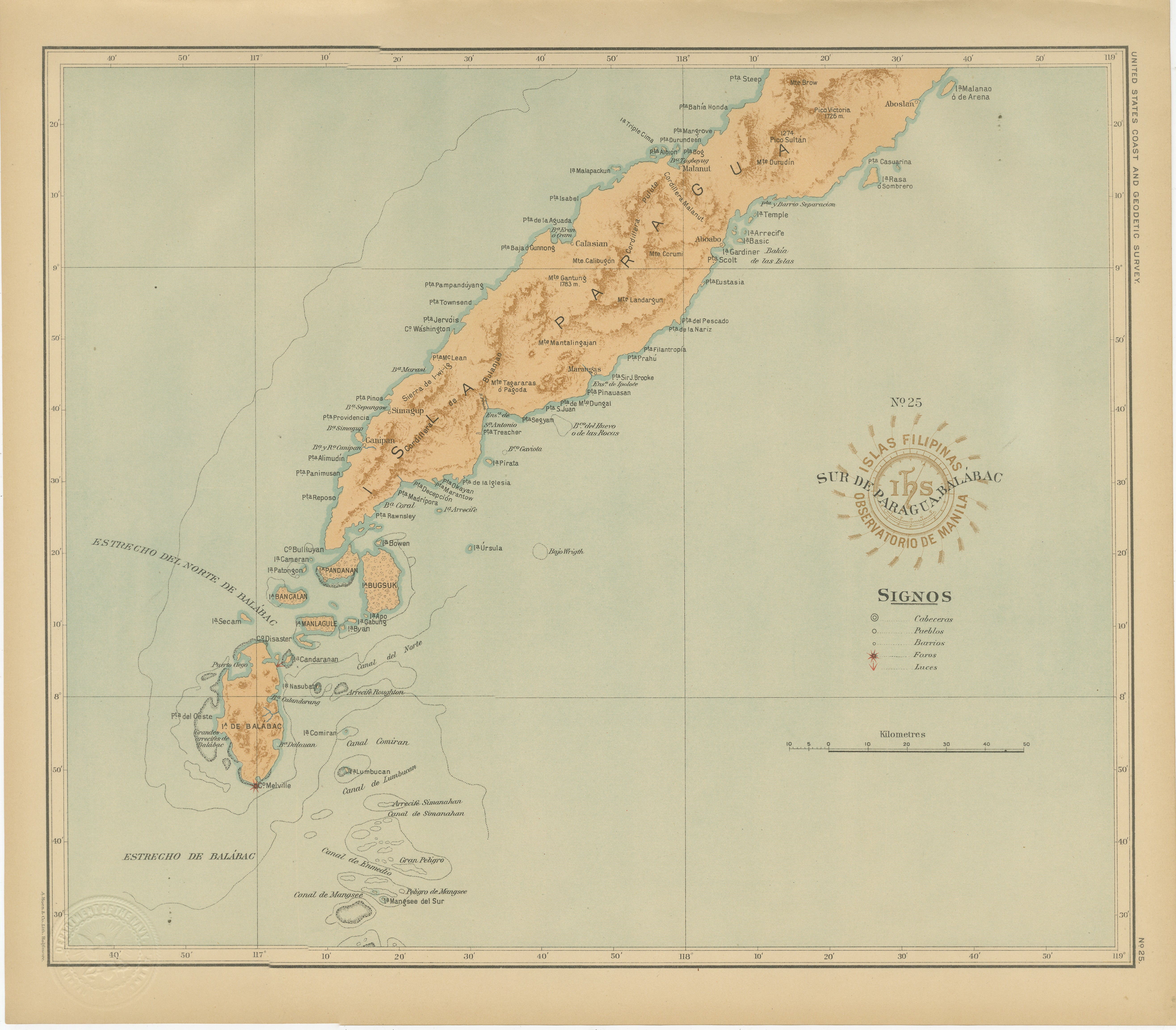
Map of Southern Palawan and the Balabac Islands – Observatorio de Manila, 1899
Located in Langweer, NL
Map of Southern Palawan and the Balabac Islands – Observatorio de Manila, 1899
This original chromolithograph titled “Islas Filipinas – Sur de Paragua y Balabac” was produced under ...
Category
Antique 1890s Philippine Maps
Materials
Paper
You May Also Like
Original Antique Map of The Philippines. C.1900
Located in St Annes, Lancashire
Fabulous map of The Philippines
Original color.
Engraved and printed by the George F. Cram Company, Indianapolis.
Published, C.1900.
Unframed.
Free shipping.
Category
Antique 1890s American Maps
Materials
Paper

Original Antique Map of US Possessions In The Pacific Ocean, C.1900
Located in St Annes, Lancashire
Fabulous map of US possessions in the Pacific Ocean
Original color.
Engraved and printed by the George F. Cram Company, Indianapolis.
Published, C.1900.
Unframed.
Free shipping.
Category
Antique 1890s American Maps
Materials
Paper

Africa. North-West Part. Century Atlas antique vintage map
Located in Melbourne, Victoria
'The Century Atlas. Africa. Southern Part'
Original antique map, 1903.
Central fold as issued. Map name and number printed on the reverse corners.
Sheet 40cm by 29.5cm.
Category
Early 20th Century Victorian More Prints
Materials
Lithograph

Central America. Century Atlas antique vintage map
Located in Melbourne, Victoria
'The Century Atlas. Central America.'
Original antique map, 1903.
Inset maps of 'The Country around Lake Nicaragua'.
Central fold as issued. Map name and number printed on the reve...
Category
Early 20th Century Victorian More Prints
Materials
Lithograph

Original Antique Map of South East Asia by Thomas Clerk, 1817
Located in St Annes, Lancashire
Great map of South East Asia
Copper-plate engraving
Drawn and engraved by Thomas Clerk, Edinburgh.
Published by Mackenzie And Dent, 1817
Unframed.
Category
Antique 1810s English Maps
Materials
Paper

Large Original Vintage Map of The Pacific Islands Including Hawaii
Located in St Annes, Lancashire
Great map of The Pacific Islands
Unframed
Original color
By John Bartholomew and Co. Edinburgh Geographical Institute
Published, circa 1...
Category
Vintage 1920s British Maps
Materials
Paper
