Items Similar to Map of the Island of Samar – Observatorio de Manila, 1899

Want more images or videos?
Request additional images or videos from the seller
1 of 9
Map of the Island of Samar – Observatorio de Manila, 1899
$520.57
£395.72
€440
CA$731.58
A$795.61
CHF 419.14
MX$9,662.78
NOK 5,269.47
SEK 4,939.70
DKK 3,369.46
About the Item
Title: Map of the Island of Samar – Observatorio de Manila, 1899
This finely executed chromolithographed map titled “Islas Filipinas – Isla de Samar” was created under the supervision of Rev. José Algué, S.J., Director of the Observatorio de Manila, and published in 1899 as Plate No. 18 from the Atlas de Filipinas. It provides an exceptionally detailed representation of the island of Samar, one of the largest and most geographically complex islands in the Philippines, located in the Eastern Visayas.
The map captures the dramatic terrain of Samar through delicate shaded reliefs and contouring in warm brown tones, contrasted against soft blue coastal waters. Major towns and settlements, including Catbalogan, Borongan, and Guiuan, are clearly labeled, as well as numerous smaller pueblos, rivers, and mountain ranges. The map also traces provincial boundaries, coastal features, and extensive river systems, highlighting the Jesuit Observatory’s precision in both geography and hydrography.
An inset at the lower left corner depicts the islands of Biliran, Cahayagan, Batac, and Laguan, with soundings and coastal detail around the Leyte coast. The legend (“Signos”) identifies administrative symbols for capitals, towns, barrios, and meteorological stations, emphasizing the scientific purpose of the *Atlas*.
Stamped with the circular mark of the “Observatorio de Manila” and embossed with the seal of the “U.S. Coast and Geodetic Survey,” this plate was part of the 1900 Washington edition of the *Atlas of the Philippine Islands*, published by the U.S. Government Printing Office. Originally based on the surveys executed by Filipino draftsmen under Jesuit direction, this series bridges Spanish cartographic tradition with early American scientific publication.
The map stands out for its accuracy, refined lithography, and elegant design, representing one of the earliest modern depictions of Samar prior to the 20th-century American surveys.
Condition: Excellent, with original hand-applied color preserved and minor age toning consistent with age. Embossed and inked stamps remain crisp and clear.
Framing tips: A dark oak or rosewood frame paired with a light cream mat highlights the contrast between the land and sea tones, ideal for library or maritime-themed interiors.
Technique: Chromolithograph on paper
Maker: Rev. José Algué, S.J., Observatorio de Manila, 1899
- Dimensions:Height: 14.57 in (37 cm)Width: 12.8 in (32.5 cm)Depth: 0.01 in (0.2 mm)
- Materials and Techniques:
- Place of Origin:
- Period:
- Date of Manufacture:1899
- Condition:Condition: Excellent, with original hand-applied color preserved and minor age toning consistent with age. Embossed and inked stamps remain crisp and clear.
- Seller Location:Langweer, NL
- Reference Number:Seller: BG-12176-181stDibs: LU3054346962152
About the Seller
5.0
Recognized Seller
These prestigious sellers are industry leaders and represent the highest echelon for item quality and design.
Platinum Seller
Premium sellers with a 4.7+ rating and 24-hour response times
Established in 2009
1stDibs seller since 2017
2,696 sales on 1stDibs
Typical response time: <1 hour
- ShippingRetrieving quote...Shipping from: Langweer, Netherlands
- Return Policy
Authenticity Guarantee
In the unlikely event there’s an issue with an item’s authenticity, contact us within 1 year for a full refund. DetailsMoney-Back Guarantee
If your item is not as described, is damaged in transit, or does not arrive, contact us within 7 days for a full refund. Details24-Hour Cancellation
You have a 24-hour grace period in which to reconsider your purchase, with no questions asked.Vetted Professional Sellers
Our world-class sellers must adhere to strict standards for service and quality, maintaining the integrity of our listings.Price-Match Guarantee
If you find that a seller listed the same item for a lower price elsewhere, we’ll match it.Trusted Global Delivery
Our best-in-class carrier network provides specialized shipping options worldwide, including custom delivery.More From This Seller
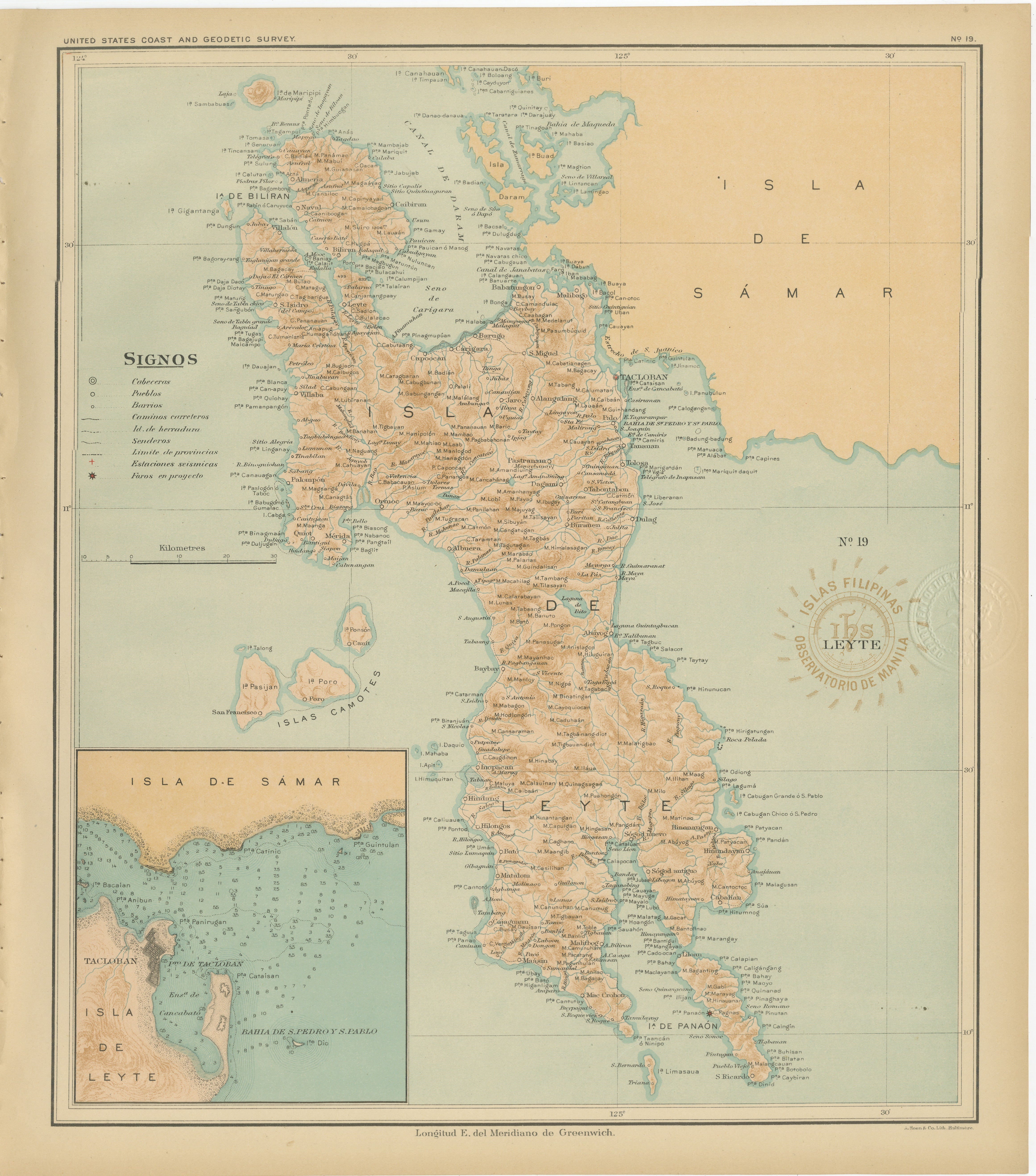
View AllMap of the Island of Leyte – Observatorio de Manila, 1899
Located in Langweer, NL
Title: Map of the Island of Leyte – Observatorio de Manila, 1899
This beautifully detailed chromolithographed map titled “Islas Filipinas – Isla de Leyte” was created under the supe...
Category
Antique 1890s Philippine Maps
Materials
Paper

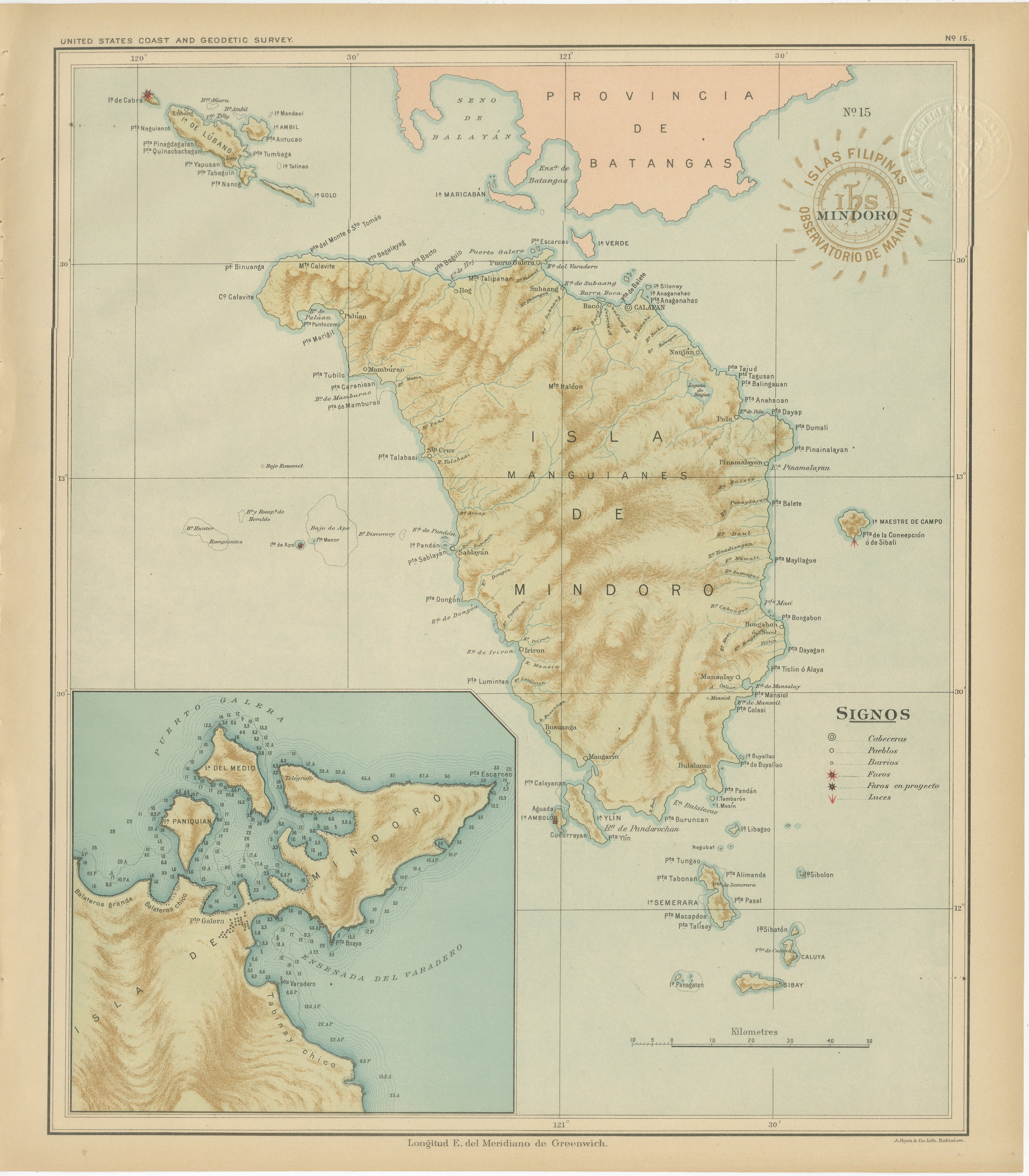
Map of the Island of Mindoro – Observatorio de Manila, 1899
Located in Langweer, NL
Title: Map of the Island of Mindoro – Observatorio de Manila, 1899
Description:
This finely executed chromolithographed map titled “Islas Filipinas – Isla de Mindoro” was published ...
Category
Antique 1890s Philippine Maps
Materials
Paper

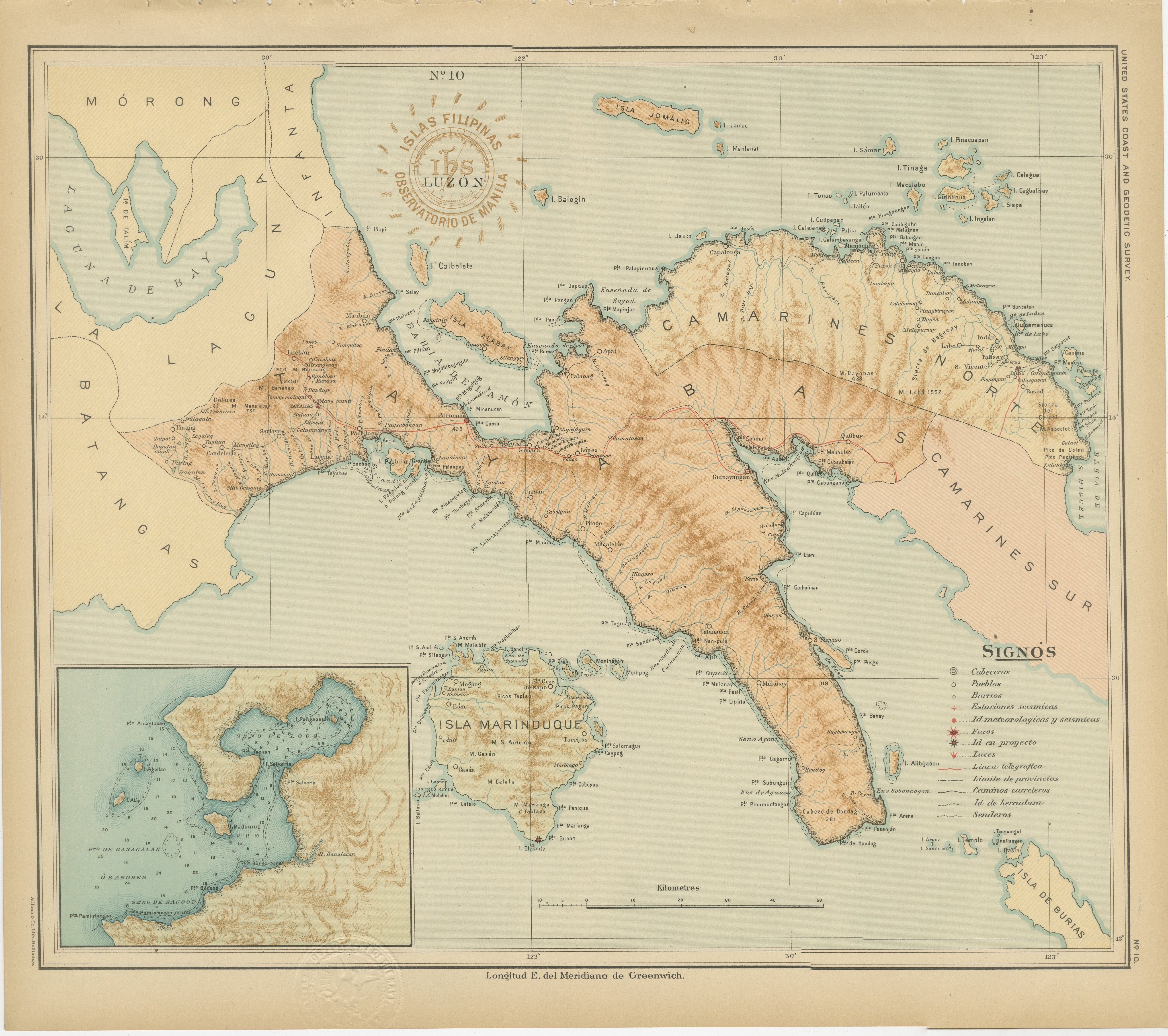
Map of Southern Luzon and Camarines Provinces – Observatorio de Manila, 1899
Located in Langweer, NL
Title: Map of Southern Luzon and Camarines Provinces – Observatorio de Manila, 1899
Description:
This chromolithographed map titled “Islas Filipinas – Luzón” was published in 1899 u...
Category
Antique 1890s Philippine Maps
Materials
Paper
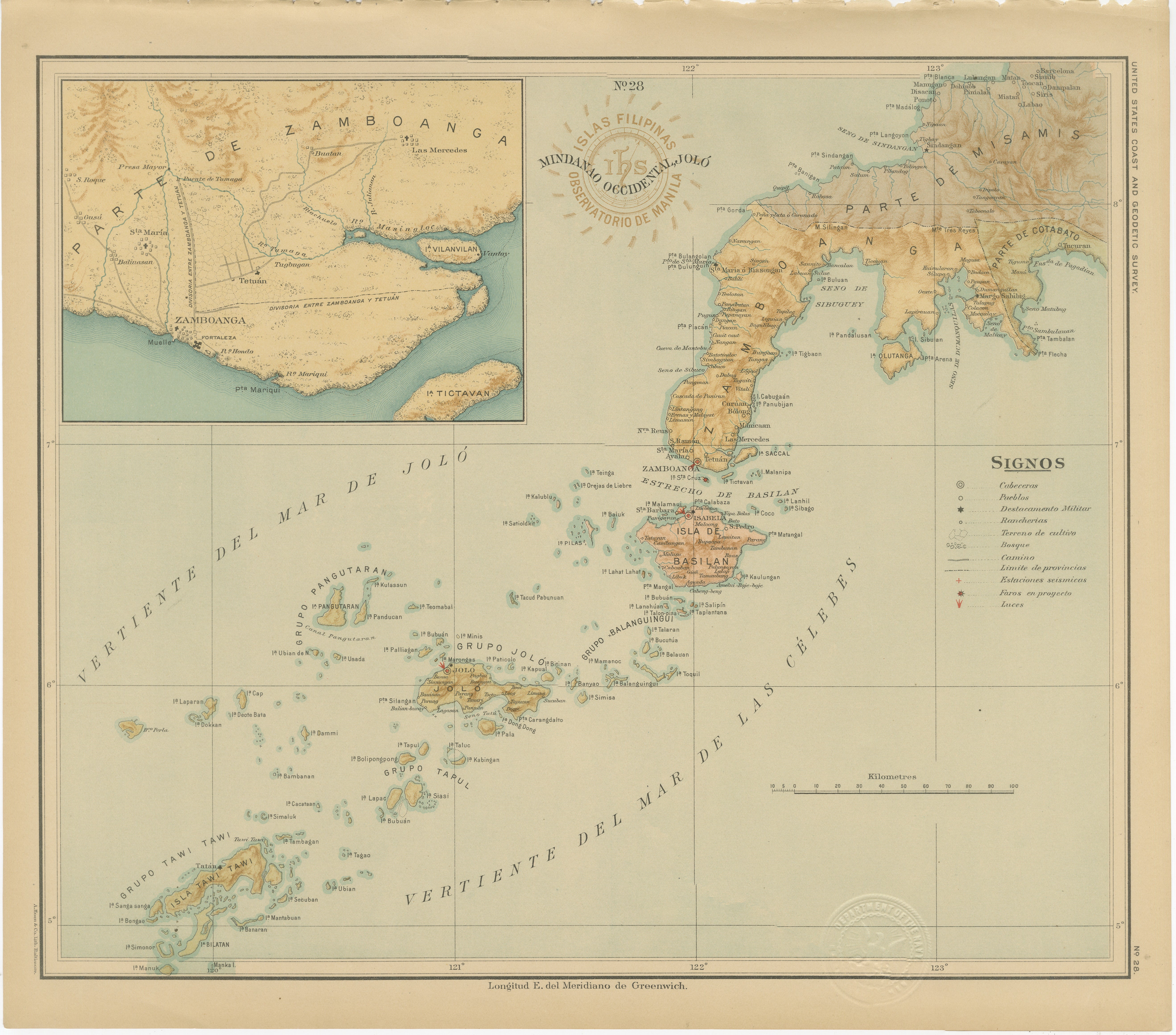
Map of Western Mindanao and the Sulu Archipelago – Observatorio de Manila, 1899
Located in Langweer, NL
Map of Western Mindanao and the Sulu Archipelago – Observatorio de Manila, 1899
This original chromolithographed map titled “Islas Filipinas – Mindanao Occidental y Joló” (Plate No....
Category
Antique 1890s Philippine Maps
Materials
Paper
Map of Romblon, Tablas, and Sibuyan Islands – Observatorio de Manila, 1899
Located in Langweer, NL
Map of Romblon, Tablas, and Sibuyan Islands – Observatorio de Manila, 1899
This detailed chromolithographed map titled “Islas Filipinas – Romblon, Tablas, Sibuyan” was created in 18...
Category
Antique 1890s Philippine Maps
Materials
Paper
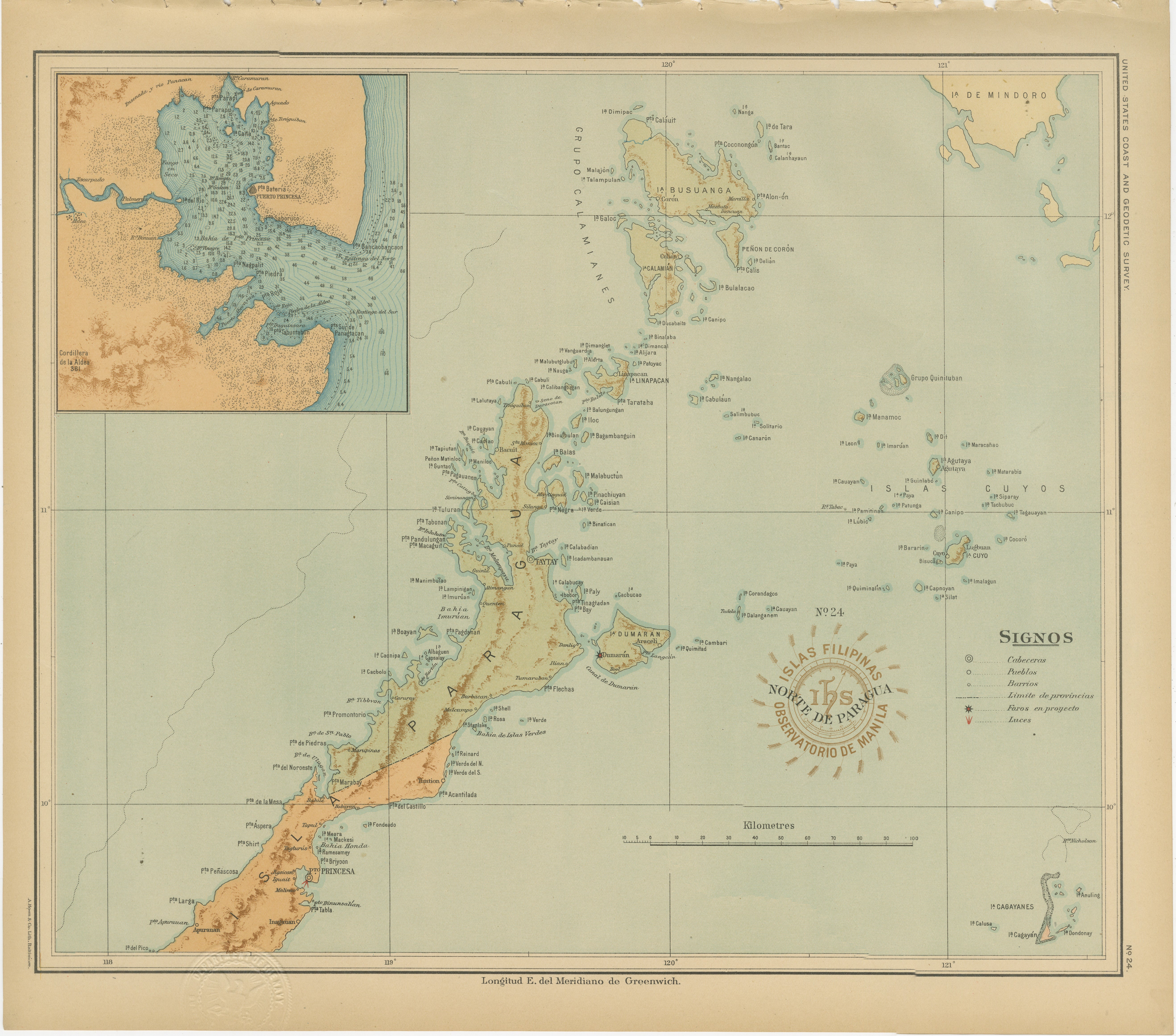
Map of the Northern Part of Palawan – Observatorio de Manila, 1899
Located in Langweer, NL
Title: Map of the Northern Part of Palawan – Observatorio de Manila, 1899
This finely detailed chromolithograph titled “Islas Filipinas – Norte de Paragua” depicts the northern regi...
Category
Antique 1890s Philippine Maps
Materials
Paper
You May Also Like
Original Antique Map of The Philippines. C.1900
Located in St Annes, Lancashire
Fabulous map of The Philippines
Original color.
Engraved and printed by the George F. Cram Company, Indianapolis.
Published, C.1900.
Unframed.
Free shipping.
Category
Antique 1890s American Maps
Materials
Paper

Large Original Antique Map of The Greek Islands. 1894
Located in St Annes, Lancashire
Superb Antique map of The Greek Islands
Published Edward Stanford, Charing Cross, London 1894
Original colour
Good condition
Unframed.
Free shipping
Category
Antique 1890s English Maps
Materials
Paper

Central America. Century Atlas antique vintage map
Located in Melbourne, Victoria
'The Century Atlas. Central America.'
Original antique map, 1903.
Inset maps of 'The Country around Lake Nicaragua'.
Central fold as issued. Map name and number printed on the reve...
Category
Early 20th Century Victorian More Prints
Materials
Lithograph

Original Antique Map of US Possessions In The Pacific Ocean, C.1900
Located in St Annes, Lancashire
Fabulous map of US possessions in the Pacific Ocean
Original color.
Engraved and printed by the George F. Cram Company, Indianapolis.
Published, C.1900.
Unframed.
Free shipping.
Category
Antique 1890s American Maps
Materials
Paper

Original Antique Map of South East Asia by Thomas Clerk, 1817
Located in St Annes, Lancashire
Great map of South East Asia
Copper-plate engraving
Drawn and engraved by Thomas Clerk, Edinburgh.
Published by Mackenzie And Dent, 1817
Unframed.
Category
Antique 1810s English Maps
Materials
Paper

Large Original Vintage Map of S.E Asia, with a Vignette of Singapore
Located in St Annes, Lancashire
Great map of South East Asia
Original color. Good condition
Published by Alexander Gross
Unframed.
Category
Vintage 1920s English Maps
Materials
Paper
