Items Similar to Original Antique Engraving of the Creation of the World According to Mozes, 1725
Want more images or videos?
Request additional images or videos from the seller
1 of 6
Original Antique Engraving of the Creation of the World According to Mozes, 1725
About the Item
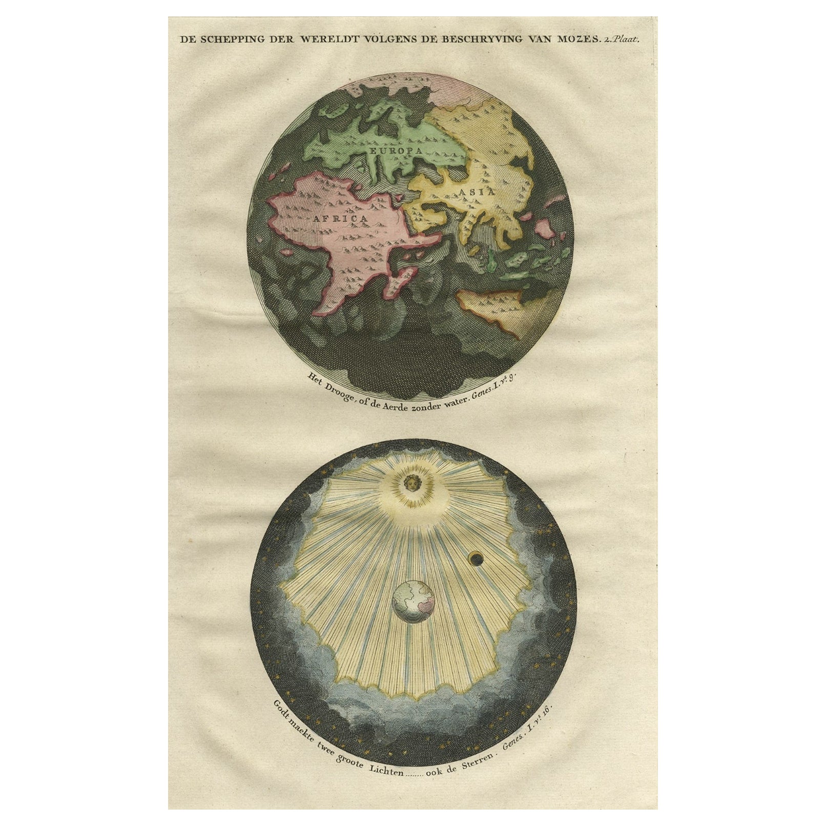
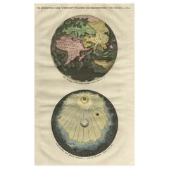
Antique map titled 'De Schepping der Wereldt volgens de Beschryving van Mozes' - This plate shows the creation of the world according to Moses. The upper depiction shows the world without water ( after Goeree); the lowest depiction shows the creation of sun,moon and stars. This plate originates from: 'Het algemeen groot historisch, oordeelkundig, chronologisch, geografisch, en letterlyk naam- en woord-boek, van den gantschen H. Bijbel. Dienende tot de gedenk-stukken der Jooden en andere oudheden, ter opheldering der H. Schrift ... Nu in't Nederduitsch overgezet, merkelyk vermeerdert, en met aanmerkingen verrykt, door Mattheus Gargon.' and it's additons: 'Byvogzel tot het algemeen groot ... Naam- en woord-boek ... En nu in zuiver Nederduitsch overgezet, merkelyk vermeerdert, en metv aanmerkingen verrykt, door Jakob van Ostade en Arn. Henr. Westerhovius.', by Augustines Calmet, published in Leiden, Amsterdam, by Samuel Luchtmans, R. & J. Wetstein en Smith 1725-1731. This is a reknown encyclopaedic dictionary on all aspects of the history, geography and culture of the Bible and Biblical times. This Dutch translation originates from Calmet's work in French including: 'Commentaire litteral sur tous les livres de l'Ancien et du Nouveau Testament ...', first published in Paris in 1707.
Artists and Engravers: Made by 'Antoine Augustin Calmet' after an anonymous artist. Antoine Augustin Calmet (1672-1757), French Benedictine. Translation by: translation by Mattheus Gargon (1661-1728), a minister in Vlissingen. Engravings in this work by A. de Putter, F. van Bleyswyk, M. Pool, Ph. van Gunst, etc.
Condition: Good, given age. Some crinkles and light creases. Edges browned and light soiling in the margins. General age-related toning and/or occasional minor defects from handling. Please study scan carefully.
Date: 1725
Overall size: 24.3 x 40 cm.
Image size: 19 x 30.7 cm.
We sell original antique maps to collectors, historians, educators and interior decorators all over the world. Our collection includes a wide range of authentic antique maps from the 16th to the 20th centuries. Buying and collecting antique maps is a tradition that goes back hundreds of years. Antique maps have proved a richly rewarding investment over the past decade, thanks to a growing appreciation of their unique historical appeal. Today the decorative qualities of antique maps are widely recognized by interior designers who appreciate their beauty and design flexibility. Depending on the individual map, presentation, and context, a rare or antique map can be modern, traditional, abstract, figurative, serious or whimsical. We offer a wide range of authentic antique maps for any budget.
- Dimensions:Height: 15.75 in (40 cm)Width: 9.57 in (24.3 cm)Depth: 0 in (0.01 mm)
- Materials and Techniques:
- Period:
- Date of Manufacture:1725
- Condition:Condition: Good, given age. Some crinkles and light creases. Edges browned and light soiling in the margins. General age-related toning and/or occasional minor defects from handling. Please study scan carefully.
- Seller Location:Langweer, NL
- Reference Number:
About the Seller
5.0
Platinum Seller
These expertly vetted sellers are 1stDibs' most experienced sellers and are rated highest by our customers.
Established in 2009
1stDibs seller since 2017
1,914 sales on 1stDibs
Typical response time: <1 hour
- ShippingRetrieving quote...Ships From: Langweer, Netherlands
- Return PolicyA return for this item may be initiated within 14 days of delivery.
More From This SellerView All
- Beautiful Original Print of The Creation of the World According to Moses, 1725Located in Langweer, NLAntique map, titled: 'De Schepping der Wereldt volgens de Beschryving van Mozes.' Two separate maps on one sheet showing the creation of the world according to Moses. The upper dep...Category
Antique 1720s Maps
MaterialsPaper
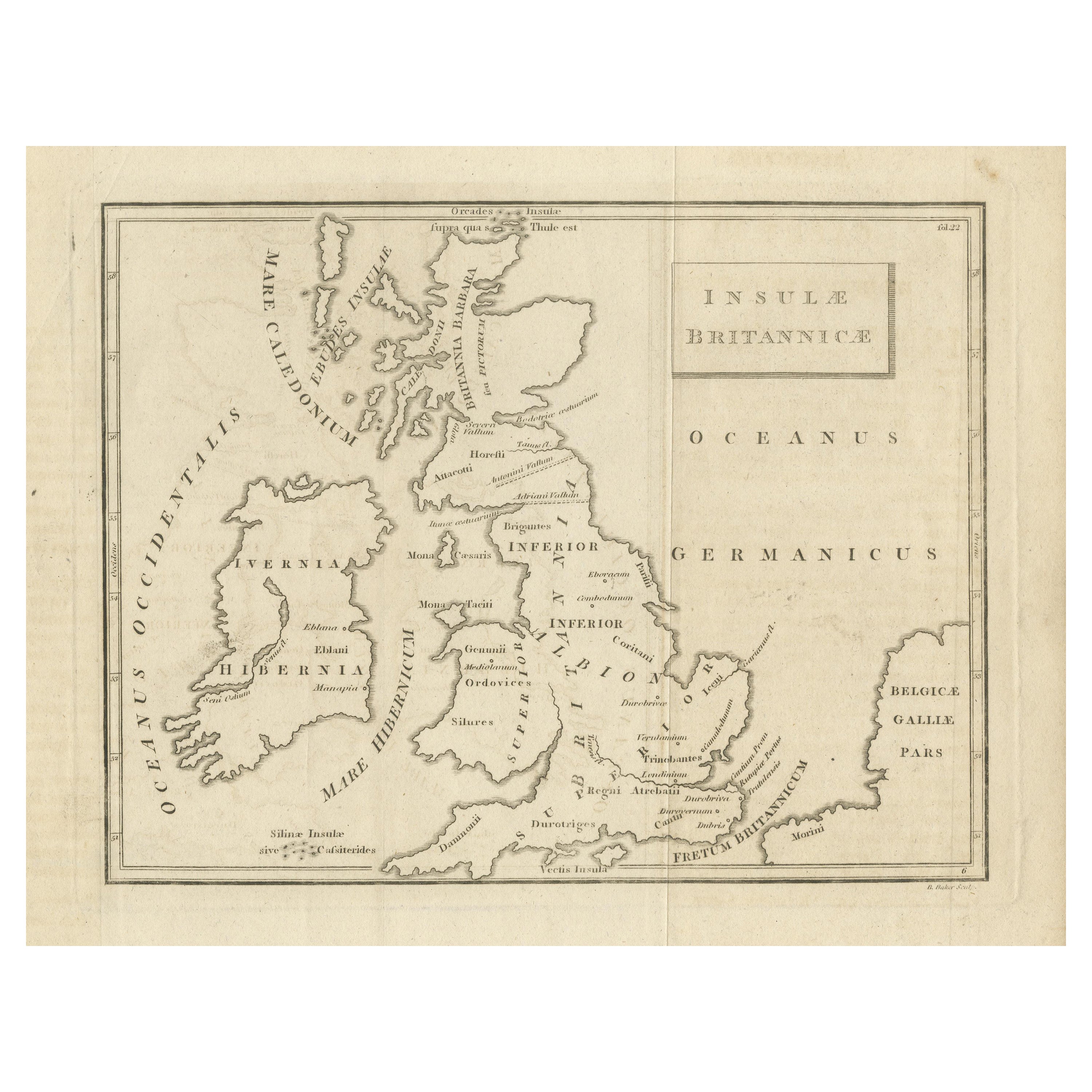
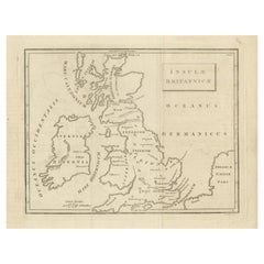
- Antique Map of the British Isles According to the Geography of the Roman EmpireLocated in Langweer, NLAntique map titled 'Insulae Britannicae'. Interesting map of Britain, Scotland, and Ireland. It shows a rudimentary outline of the islands according to the geography of the Roman Emp...Category
Antique Late 18th Century Maps
MaterialsPaper
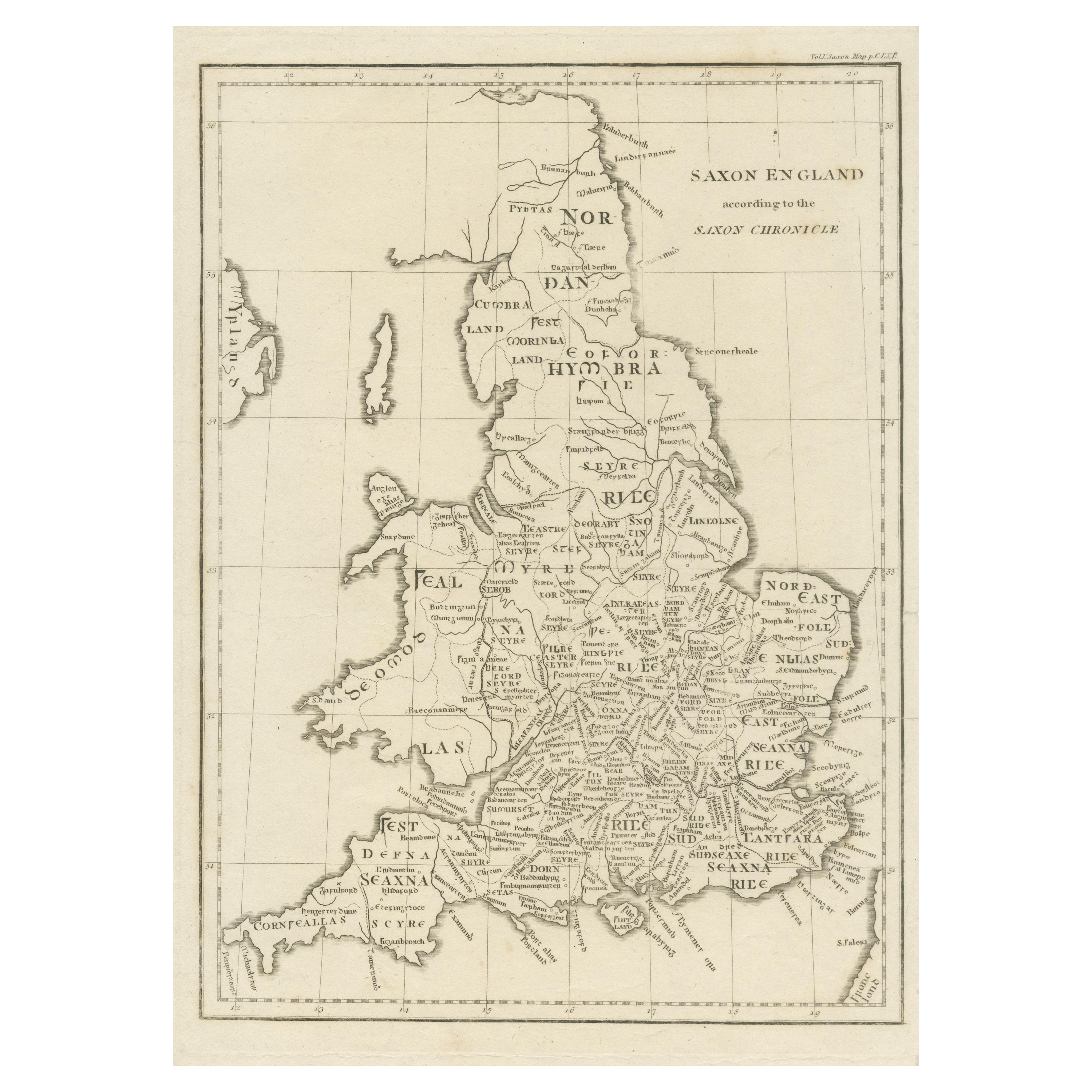
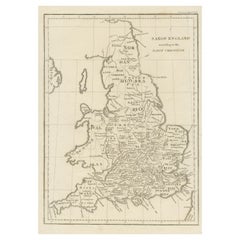
- Antique Map of Saxon England according to the Anglo-Saxon ChronicleLocated in Langweer, NLAntique map titled 'Saxon England According to the Saxon Chronicle'. Map of Saxon England based upon descriptions in the Anglo-Saxon Chronicle, a collection of annals in Old English ...Category
Antique Early 19th Century Maps
MaterialsPaper
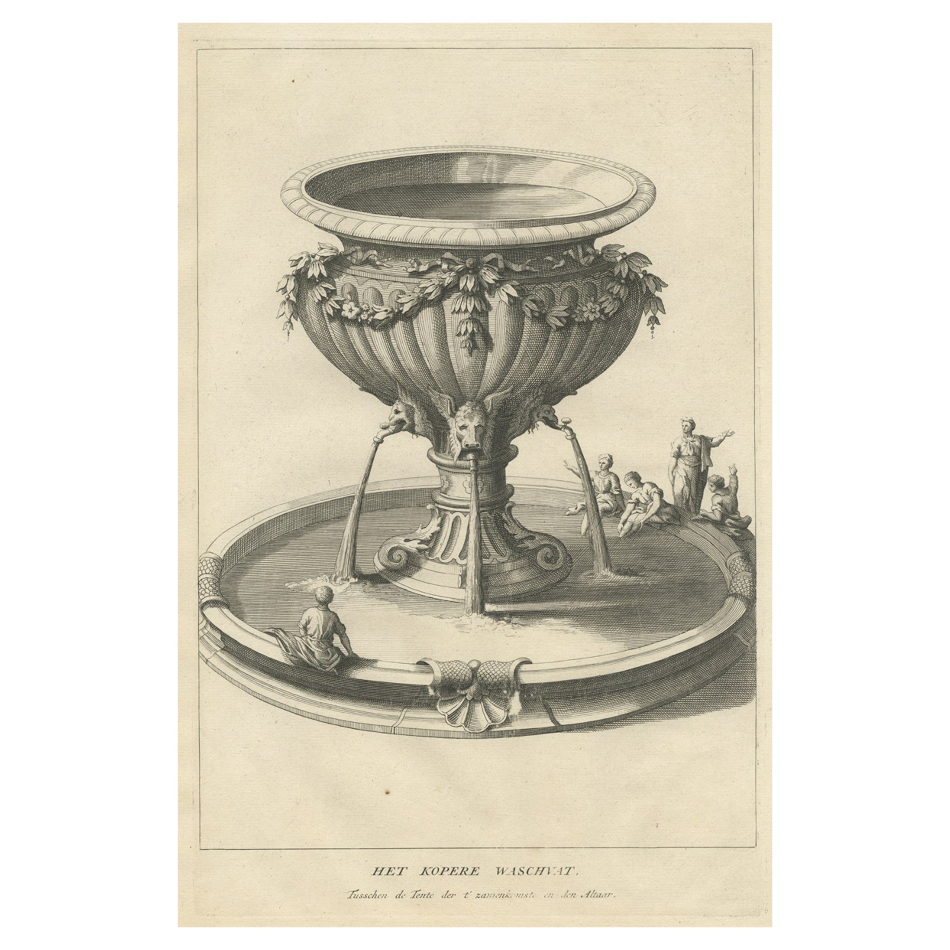
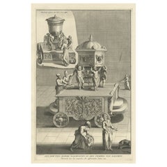
- Antique Engraving of the Brass Laver in Solomon's Temple, Jerusalem, ca.1725Located in Langweer, NLAntique religion print titled 'Het kopere Waschvat, Tusschen de Tente der t'zamenkomst en den altaar'. Antique print of the Brass Laver in Solomon's Temple. This print originates...Category
Antique 1720s Prints
MaterialsPaper
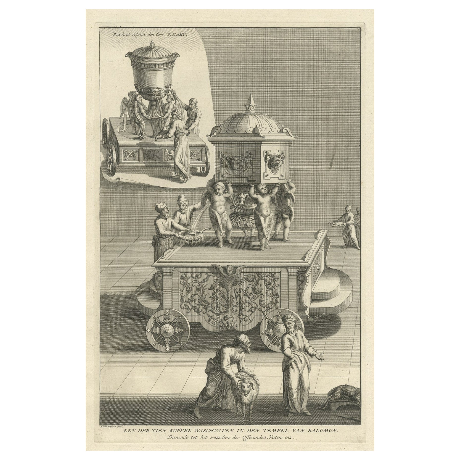
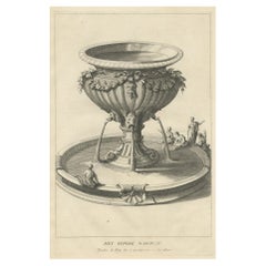
- Antique Engraving of One of the Ten Brass Lavers in Solomon's Temple, 1725Located in Langweer, NLAntique religion print titled 'Een der tien Kopere Waschvaten in den Tempel van Salomon'. This print depicts one of the ten Brass Lavers in Solomon's Temple. This print originate...Category
Antique 1720s Prints
MaterialsPaper
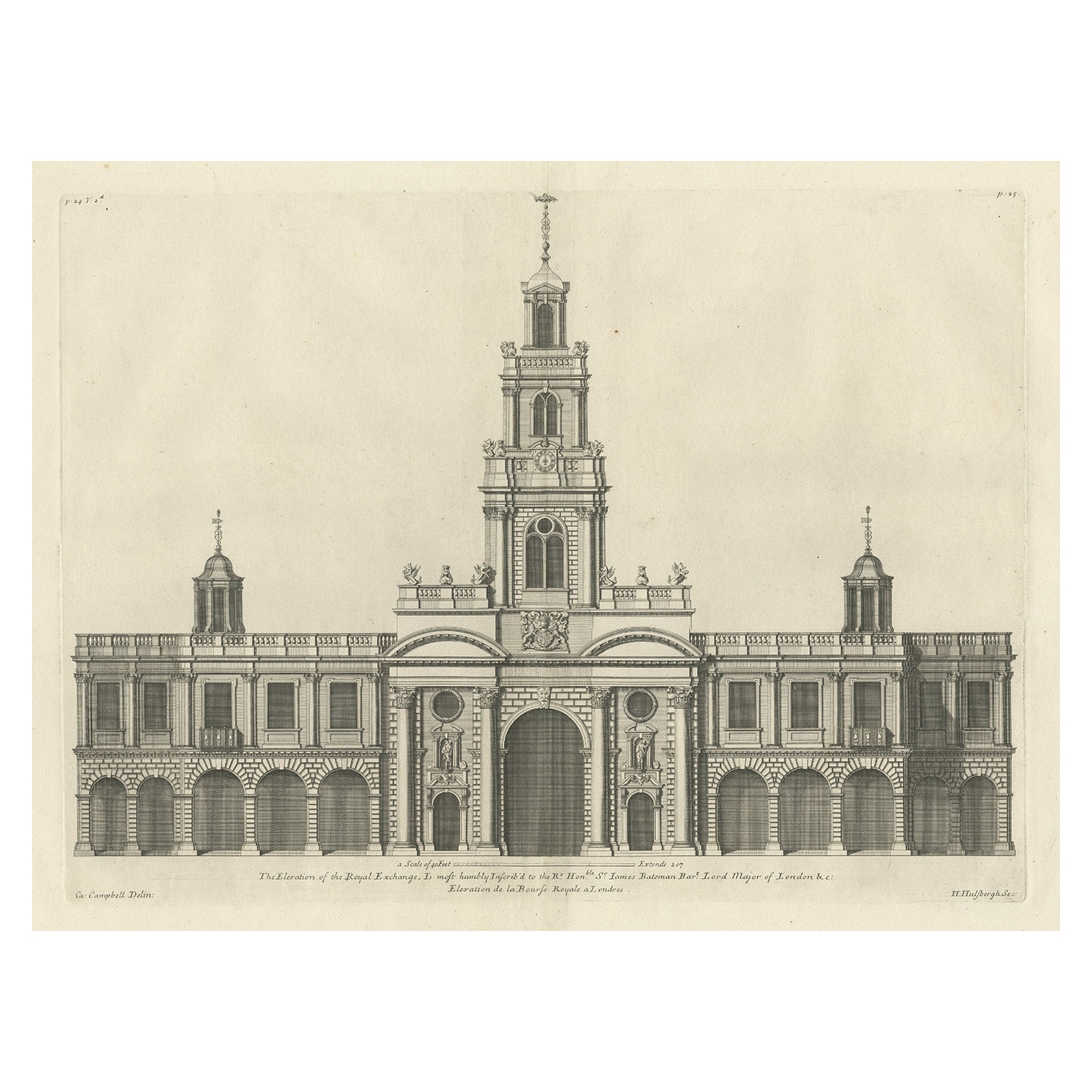
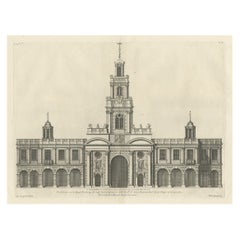
- Engraving of the Entrance Facade of the Royal Exchange, Cornhill, London, 1725Located in Langweer, NLAntique print titled 'The Elevation of the Royal Exchange (..)'. Old engraving of the entrance facade of the Royal Exchange, Cornhill. This print originates from 'Vitruvius Brita...Category
Antique 1720s Architectural Models
MaterialsPaper
You May Also Like
- According to The Rolling Stones Hardcover Table BookLocated in North Hollywood, CAThe Rolling Stones, ACCORDING TO THE ROLLING STONES. California: Chronicle Books, 2003. First Edition; First Printing. Hardcover. Large Hardcover Book. 12 X 9 X 1.6 inches; 360 pages. Printed signatures of all of them, great collectible Rock N Roll hardcover coffee table book. Title: According to the Rolling Stones Publisher: Music Sales Publication Date: 2003 Binding: Hardcover Synopsis: Here's the inside story: the history of the Rolling Stones - according to the Rolling Stones. Mick Jagger, Keith Richards, Charlie Watts, and Ronnie Wood have come together for this remarkable project. They've also opened up their personal and band archives to include many rare and intimate images that are interwoven with the text. The book gets right to the heart of what makes the Stones the Stones, as musicians, songwriters, performers, and colleagues. They describe how their music has evolved and how it has affected and changed their lives. They also reveal, with refreshing frankness, how their own lives have helped, or hindered, their music-making. The Stones' own words - insightful, funny, poignant, surprising, and above all, completely authentic - are complemented by insider reflections from key players in their story over the years such as Ahmet Ertegun, David Bailey, and Cameron Crowe. A comprehensive reference section including discography, and chronology, studded with the Stones' personal comments on the music and memories, completes this must-read volume. Here, in their own words and images, is the life and work of a band which has played the soundtrack of our lives for the last forty years. According to the Rolling Stones hews closely to the formula set in 2000 by the publication of The Beatles Anthology. Like its predecessor, it's a beautiful coffee table tome with hundreds of gorgeous photographs, from childhood pics of Mick Jagger and Keith Richards to concert shots from the 40 Licks Tour. The text is taken from recent interviews with the band's four latter-day members (Mick, Keith, Charlie Watts, and Ronnie Wood). Notably missing, however, is any contribution from former bassist Bill Wyman, who left the band in the early '90s and published his own history of the band in 2002, Rolling with the Stones. Where Wyman is an obsessive collector and diarist, the other Stones are more impressionistic in their memories, lending an approach to history as casual as the band’s concerts are rigorously planned and staged. The first half of the Stones story has plenty of high drama (tours through the segregated South, Brian Jones's death, Altamont), which no one seems eager to reflect on deeply. (Charlie is the only one even to mention Altamont.) The more recent years has seen a long string of ever-more-successful tours and ever-less-popular albums, interrupted only by Mick and Keith’s near divorce in the '80s, plus rehab stints for Charlie and Ronnie. While The Beatles Anthology offered the surviving members' interpretations of their experiences at a distance of 30 or more years, the Stones are still living the tale they're trying to tell--and they aren’t always the most self-aware narrators. Or generous: Wyman's three-decade tenure is given short shrift, but the book finds enough space for some unnecessary digs (Wyman has "tiny hands," we're told, and an "almost effeminate" style of playing). To flesh out the band members' own recollections, the book also contains 13 essays from music-industry friends (Ahmet Ertegun, Marshall Chess), collaborators (Don Was), famous fans (Sheryl Crow...Category
21st Century and Contemporary American Modern Books
MaterialsPaper
- Large Original Antique Map of The World, Fullarton, C.1870Located in St Annes, LancashireGreat map of the World. Showing both hemispheres From the celebrated Royal Illustrated Atlas Lithograph. Original color. Published by Fullarton, Edinburgh, C.1870 Unframed. Rep...Category
Antique 1870s Scottish Maps
MaterialsPaper
- Original Antique Map of The World by Thomas Clerk, 1817Located in St Annes, LancashireGreat map of The Eastern and Western Hemispheres On 2 sheets Copper-plate engraving Drawn and engraved by Thomas Clerk, Edinburgh. Published by Mackenzie And Dent, 1817 ...Category
Antique 1810s English Maps
MaterialsPaper
- Large Original Antique Map of the World, Fullarton, circa 1870Located in St Annes, LancashireGreat map of the World. From the celebrated Royal Illustrated Atlas Lithograph. Original color. Published by Fullarton, Edinburgh, circa 1870. Unframed.Category
Antique 1870s Scottish Maps
MaterialsPaper
- Silver Leaf Foil Wall World Map Engraving Based on the Original Moses Pitt, 1681Located in GBWe are delighted to offer for sale this lovely antique style pictorial silver leaf foil world map taken from and original engraving my Moses Pitt, 1681 This is a very interesting ...Category
20th Century English Modern Maps
MaterialsSilver Leaf
- Large Original Vintage Map of The World, circa 1920Located in St Annes, LancashireGreat map of The World Original color. Good condition / minor foxing Published by Alexander Gross Unframed.Category
Vintage 1920s English Maps
MaterialsPaper


Recently Viewed
View AllMore Ways To Browse
The Creation
Moon And Stars
Collectables From The 19 Century
16th Engraving
16th Century Engraving
Antique Paris Engravings
French Interior Engraving
Antique Door Handles And Plates
Antique Door Handle Plates
Antique Pool
18th Century Bible
Antique French Bible
Rare Bible
Sun Moon Stars
Map Of Stars
Antique Sun And Moon
French Bible
Biblical Antiques