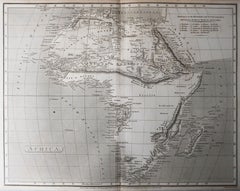
Original Antique Map of Africa, Arrowsmith, 1820
View Similar Items


Want more images or videos?
Request additional images or videos from the seller
1 of 6
Auction endedBrowse Current Auctions
Original Antique Map of Africa, Arrowsmith, 1820
About the Item
- Dimensions:Height: 10.5 in (26.67 cm)Width: 16 in (40.64 cm)Depth: 0.07 in (1.78 mm)
- Materials and Techniques:Paper,Other
- Place of Origin:
- Period:
- Date of Manufacture:1820
- Condition:Wear consistent with age and use.
- Seller Location:St Annes, GB
- Reference Number:1stDibs: LU1836331113372
About the Seller
4.9
Platinum Seller
These expertly vetted sellers are 1stDibs' most experienced sellers and are rated highest by our customers.
1stDibs seller since 2016
2,538 sales on 1stDibs
Associations
International Confederation of Art and Antique Dealers' Associations
More From This SellerView All
- Original Antique Map of Italy. Arrowsmith. 1820Located in St Annes, LancashireGreat map of Italy Drawn under the direction of Arrowsmith Copper-plate engraving Published by Longman, Hurst, Rees, Orme and Brown, 1820 Unframed.Category
Antique 1820s English Maps
MaterialsPaper

- Original Antique Map of Hungary, Arrowsmith, 1820Located in St Annes, LancashireGreat map of Hungary Drawn under the direction of Arrowsmith. Copper-plate engraving. Published by Longman, Hurst, Rees, Orme and Brown, 1820 Unframed.Category
Antique 1820s English Maps
MaterialsPaper

- Original Antique Map of France, Arrowsmith, 1820Located in St Annes, LancashireGreat map of France Drawn under the direction of Arrowsmith. Copper-plate engraving. Published by Longman, Hurst, Rees, Orme and Brown, 1820 Unframed.Category
Antique 1820s English Maps
MaterialsPaper

- Original Antique Map of China, Arrowsmith, 1820Located in St Annes, LancashireGreat map of China Drawn under the direction of Arrowsmith Copper-plate engraving Published by Longman, Hurst, Rees, Orme and Brown, 1820 Unfr...Category
Antique 1820s English Maps
MaterialsPaper

- Original Antique Map of Russia By Arrowsmith. 1820Located in St Annes, LancashireGreat map of Russia Drawn under the direction of Arrowsmith Copper-plate engraving Published by Longman, Hurst, Rees, Orme and Brown, 1820 Unframed.Category
Antique 1820s English Maps
MaterialsPaper

- Original Antique Map of Central America / Florida, Arrowsmith, 1820Located in St Annes, LancashireGreat map of Central America. Drawn under the direction of Arrowsmith. Copper-plate engraving. Published by Longman, Hurst, Rees, Orme and Brown, 1820 Unframed.Category
Antique 1820s English Maps
MaterialsPaper

You May Also Like
- Original Antique Map of AfricaLocated in Langweer, NLAntique map titled 'Afrika'. Original antique map of Africa, drawn by Van Beusekom. Published by 'Seyffardt's Boekhandel' in Amsterdam, circa 1870.Category
Antique Late 19th Century Maps
MaterialsPaper
 $297 Sale Price20% Off
 - Antique Map of New Zealand by Arrowsmith '1844'Located in Langweer, NLAntique map titled 'Map of the colony of New Zealand from official documents'. A scarce map of New Zealand. First issued in the 1830s, this state sh...Category
Antique Mid-19th Century Maps
MaterialsPaper
 $1,433 Sale Price24% Off
 - Uncoulored Original Antique Map of Western Africa, 1749Located in Langweer, NLInteresting detailed German antique map titled 'Neue Vorstellung der Abendlaendischen Küsten von Africa (..)'. Original antique map of Western Africa. This map originates from 'Neue ...Category
Antique Mid-18th Century Maps
MaterialsPaper
 $349 Sale Price20% Off
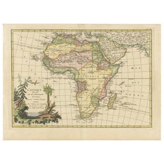
 - Original Antique Hand- Map of Africa by Allard '1697'Located in Langweer, NLAntique map titled 'Novissima et Perfectissima Africae (..)'. Beautiful large map of Africa. This is the 3rd state of the map, with climate notation add...Category
Antique Late 17th Century Maps
MaterialsPaper
 $1,228 Sale Price25% Off
 - Original Antique Map of Africa with large decorative cartoucheLocated in Langweer, NLOriginal antique map titled 'L'Afrique divisée en ses principaux États'. Attractive and precise map of Africa, with large decorative cartouche. Engraved by Janvier. Published by Dela...Category
Antique Late 18th Century Maps
MaterialsPaper
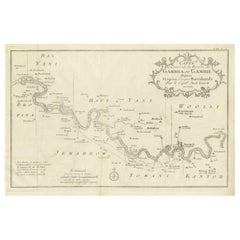
- Antique Map of Gambia, West AfricaLocated in Langweer, NLAntique map titled 'Carte du Cours de la Riviere de Gambra ou Gambie (..)'. Detailed map of Gambia, West Africa, surrounded by Senegal with decorative title based on information supp...Category
Antique Mid-18th Century Maps
MaterialsPaper
Recently Viewed
View AllMore Ways To Browse
Copper Plate Engraving
African Plate
Antique Hurst
Victorian Fence
Battle Maps
Russian Antique Plates
Floor Vase Wood
Map Print Set
Mariner Furniture
Antique World Globe Map
Antique Blackwood
Antique Furniture Missouri
Roman Map
Antique Indian Maps
Antique Marine Maps
Antique Africa Maps And Atlases Africa Maps
Antique Map California
Map Of Sweden