Items Similar to Original Old Engraving, Bird's Eye View of Cangoxuma (Kagoshima) in Japan, 1669
Want more images or videos?
Request additional images or videos from the seller
1 of 5
Original Old Engraving, Bird's Eye View of Cangoxuma (Kagoshima) in Japan, 1669
About the Item
Rare Antique print, titled: 'Cangoxuma.'
A stunning bird's eye view of the coastal city Cangoxuma (Kagoshima) in Japan. It shows several boats in the harbour, as well as the lighthouse. Arnoldus Montanus' "Gedenkwaerdige Gesantschappen der Oost-Indische Maatschappy in 't Vereenigde Nederland aan de Kaisaren van Japan […]. Amsterdam: Jacob Meurs, 1669.
Artists and Engravers: Made by an anonymous engraver after 'Arnoldus Montanus'.
Condition: Very good, given age. Original folds, as issued. Nice dark impression. Some creasing in the left edge of the image. A small stain in the top edge of the image. Top and right margins faintly browned with age. General age-related toning and/or occasional minor defects from handling. Please study scan carefully.
- Dimensions:Height: 12.68 in (32.2 cm)Width: 23.31 in (59.2 cm)Depth: 0 in (0.02 mm)
- Materials and Techniques:
- Period:1660-1669
- Date of Manufacture:1669
- Condition:Wear consistent with age and use.
- Seller Location:Langweer, NL
- Reference Number:
About the Seller
5.0
Platinum Seller
These expertly vetted sellers are 1stDibs' most experienced sellers and are rated highest by our customers.
Established in 2009
1stDibs seller since 2017
1,916 sales on 1stDibs
Typical response time: <1 hour
- ShippingRetrieving quote...Ships From: Langweer, Netherlands
- Return PolicyA return for this item may be initiated within 14 days of delivery.
More From This SellerView All
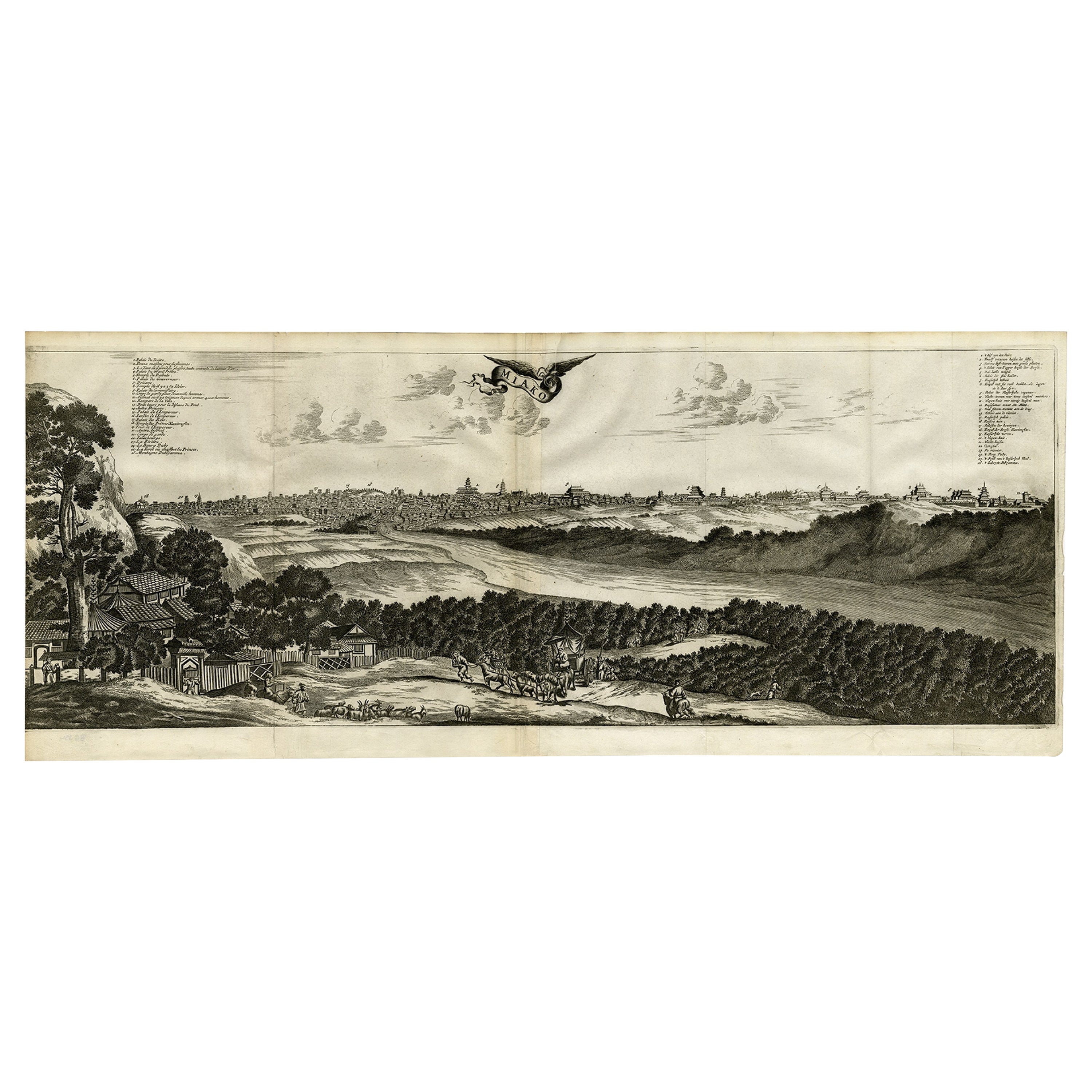
- Old Engraving of A Panoramic Bird's Eye View of Miaco 'Kyoto', Japan, 1669Located in Langweer, NLDescription: Antique print, titled: 'Miako.' - A panaromic bird's eye view of Miaco (Kyoto). Arnoldus Montanus' "Gedenkwaerdige Gesantschappen der Oost-Indische Maatschappy in 't Ver...Category
Antique 1660s Maps
MaterialsPaper
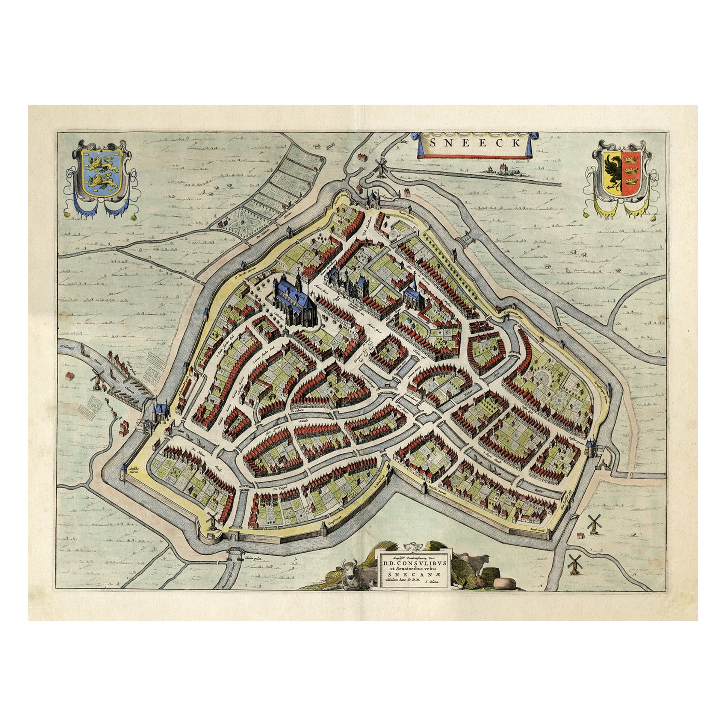
- Original Old Bird's-eye View plan of Sneek, Friesland, The Netherlands, 1649Located in Langweer, NLAntique map titled: 'Sneeck.' Bird's-eye view plan of Sneek, Friesland, The Netherlands. Text in Latin on verso. This plan originates from the famous city Atlas: 'Toneel der Steeden'...Category
Antique 1640s Maps
MaterialsPaper
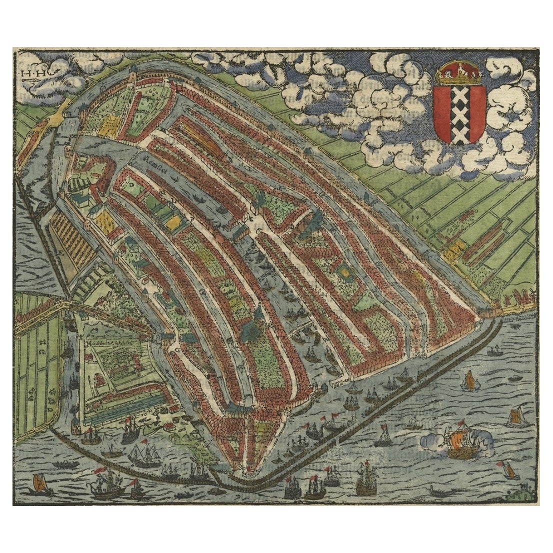
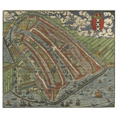
- Old Original Hand-Colored Engraving of a Bird's-eye Plan of Amsterdam, ca.1580Located in Langweer, NLDescription: Antique print, untitled. Bird's-eye plan of Amsterdam portrayed on a sheet of German text. Remarkably detailed for its size, hundreds of individual buildings and hou...Category
Antique 16th Century Maps
MaterialsPaper
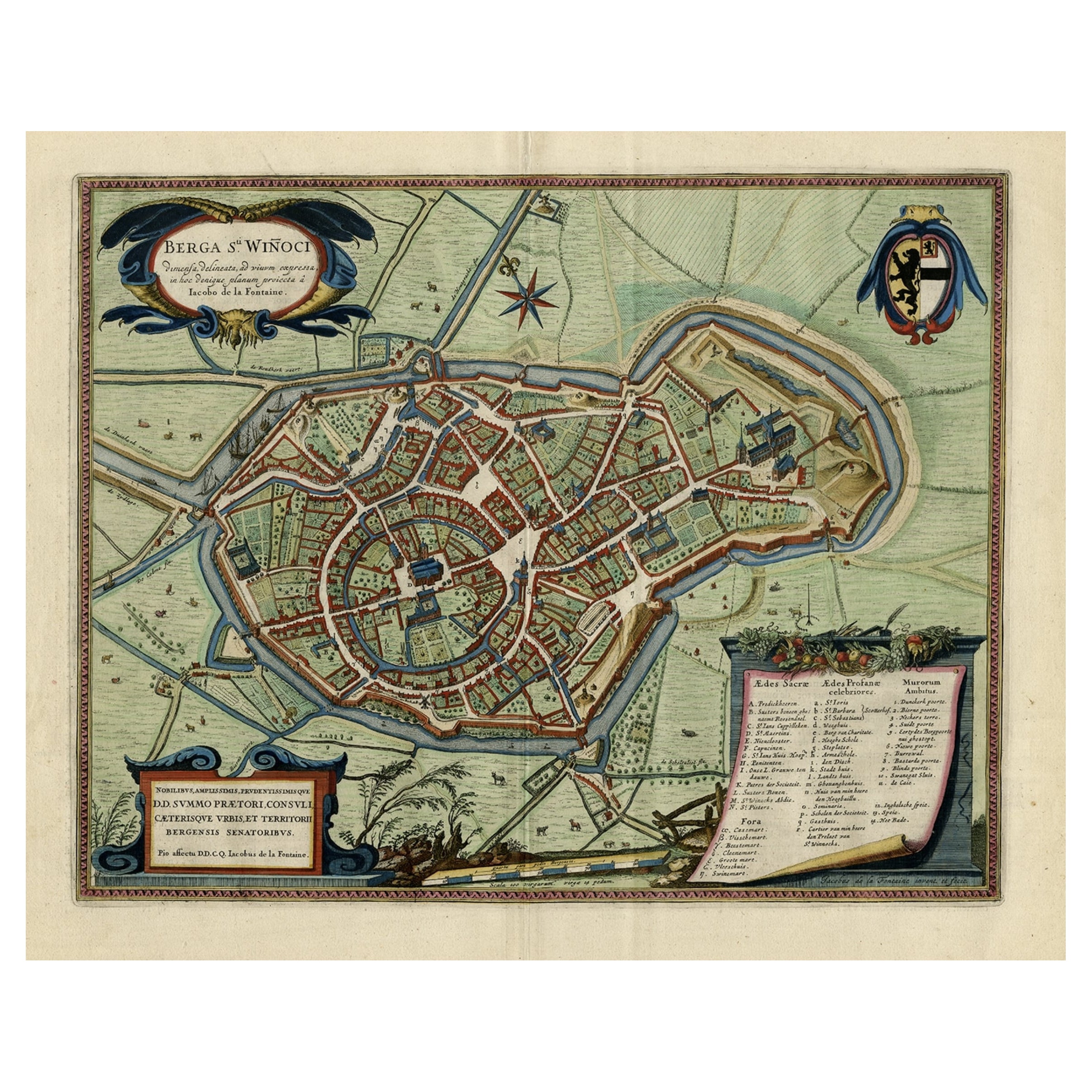
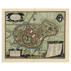
- Original Old Bird's-Eye View Plan of Sint-Winoksbergen or Bergen in France, 1649Located in Langweer, NLAntique map titled 'Berga Sti Winoci.' - Bird's-eye view plan of Sint-Winoksbergen in France, with key to locations and coats of arms. Text in Dutch on verso. This plan originates from the famous city Atlas: 'Toneel der Steeden' published by Joan Blaeu...Category
Antique 1640s Maps
MaterialsPaper
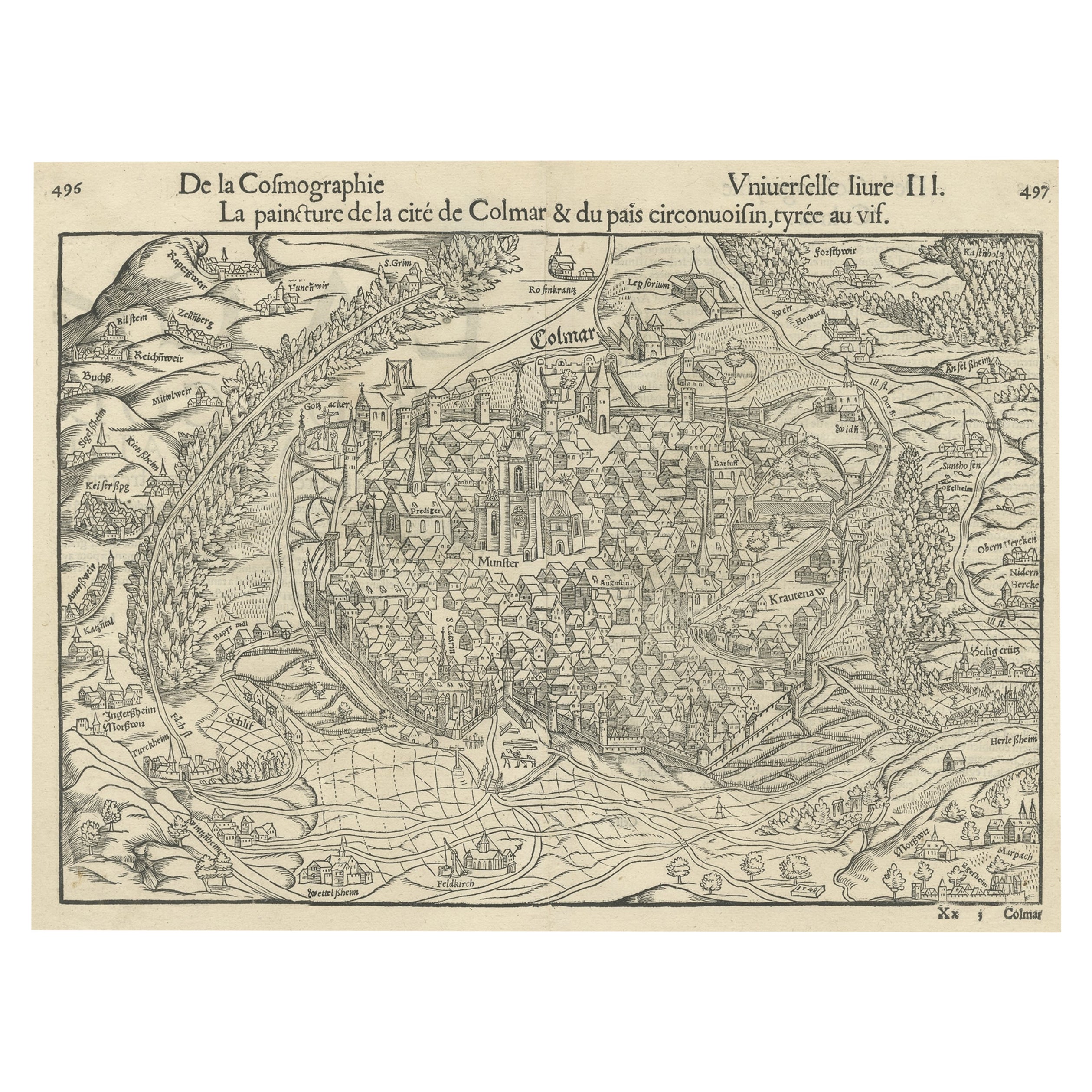
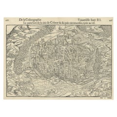
- Original Antique Bird's-Eye View of Colmar, Alsace, France, 1552Located in Langweer, NLAntique map titled 'La Paincture de la cité de Colmar & du pais circonuoisin'. Original antique bird's-eye view of Colmar, Alsace, France. This map originates from 'La Cosmograph...Category
Antique 16th Century Maps
MaterialsPaper
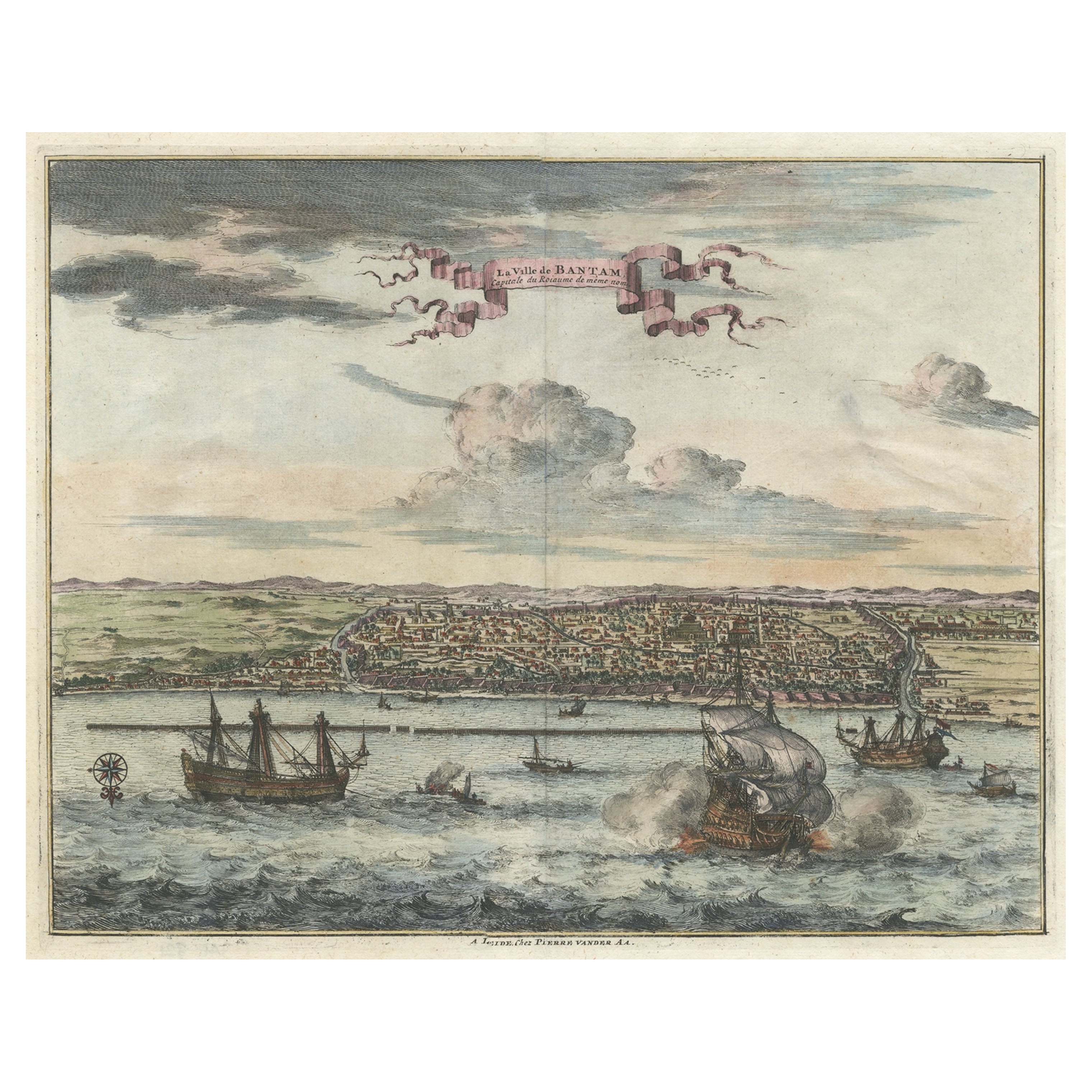
- Original Antique Bird's Eye View of Banten or Bantam in Java, Indonesia, 1725Located in Langweer, NLAntique print titled 'La Ville de Bantam capitale du Roiaume de meme nom'. A bird's eye view of the city Banten or Bantam near the western end of Java in Indonesia. Several tall ...Category
Antique 1720s Prints
MaterialsPaper

You May Also Like
- Alpine Ski Photograph, 'Panoramic View', Taken from Original 1930s PhotographLocated in Oxfordshire, GBVintage, antique Alpine Ski photograph. 'Panoramic View', a new mounted black and white photographic image after an original 1930s skiing photograph. Black and white alpine photos are the perfect addition to any home or ski lodge, so please do check out our other ski photos...Category
Vintage 1930s English Sporting Art Sports Equipment and Memorabilia
MaterialsPaper
- Old Nautical Map of CorsicaLocated in Alessandria, PiemonteST/556/1 - Old map of Corsica isle, surveyed by Captain Hell, of the French Royal Navy in 1824, engraved and published on 1874, with additions and corre...Category
Antique Early 19th Century English Other Prints
MaterialsPaper
- Old Horizontal Map of EnglandBy TassoLocated in Alessandria, PiemonteST/520 - Old rare Italian map of England, dated 1826-1827 - by Girolamo Tasso, editor in Venise, for the atlas of M.r Le-Sage.Category
Antique Early 19th Century Italian Other Prints
MaterialsPaper
- Framed Johann Elias Ridinger Engraving, 18th Stag EngravingLocated in Perth, GBFine 18th century engraving of a stag, after the hunt, with a magnificient dog at rest, in a country scene, beautifully depicted.Category
Antique 18th Century Prints
MaterialsPaper
- Framed Engraving By Matthaus Seutter Of Sphaerae ArtificialesLocated in Essex, MACartographer from Germany 1678-1757. Hand colored. Gilt wood frame. Estate of William Hodgins.Category
Antique Early 1700s German Prints
MaterialsPaper
- 1876 "Gettysburg, The Repulse of Longstreet's Assault." EngravingLocated in Colorado Springs, COPresented here is an 1876 engraving of John B. Bachelder and James Walker’s Gettysburg. The Repulse of Longstreet’s Assault. The engraved scene depicts the decisive battle on the final day of the Battle of Gettysburg. Researched by the photographer and topographer John B. Bachelder and painted by James Walker, the original painting was created in 1870. This detailed engraving was done by H. B. Hall Jr. and published by James Drummond Ball. Otherwise called Pickett’s Charge, the battle occurred on July 3, 1863. Pickett’s corp commander, Lieutenant General James Longstreet was placed in charge of the attack despite his hesitations. Longstreet’s central role led to the title of the work, Repulse of Longstreet’s Assault. In an attempt to gain control of an important supply route, nine Confederate brigades charged across three-quarters of a mile of open ground against cannon fire to take Cemetery Ridge from the defending Union Army. Despite their overwhelming numbers, the Confederate forces were repelled with considerable casualties marking not only a decisive victory for the Union, but also the beginning of the slow defeat of Lee’s Army. The furthest the charging forces advanced before being repulsed would forever be known as the “High Water Mark of the Confederacy.” The Confederate army never recovered from the losses at Gettysburg and it effectively ended Lee’s campaign into Pennsylvania. The engraving gives the perspective from the Union rear, one that encompasses most of the battlefield, from Big Round Top on the left to the northern reaches of Cemetery Ridge on the right. The Confederate lines at Seminary Ridge are in the far distance, partially obscured by bursting shells. The image centers on the main Confederate assault, in the vicinity of what today are known as "The Copse" and "The Bloody Angle." The composition has elemen...Category
Antique 1870s American Prints
MaterialsPaper


Recently Viewed
View AllMore Ways To Browse
Boat Collectables
Antique Engravings Of Birds
Jacob Amsterdam
Japan Maps
Map Japan
Map Of Japan
Lighthouse Antique
Antique Lighthouse
Antique Japanese Map
Antique Japanese Maps
Antique Map Of Japan
The Antique Lighthouse
Antique Map Japan
Coastal Maps
Antique Japanese Bird Prints
Birds Eye View Map
Antique Print Coastal
Antique Furniture East London