Items Similar to Rare Antique Map of the Region of Franekeradeel, The Netherlands 1664

Want more images or videos?
Request additional images or videos from the seller
1 of 5
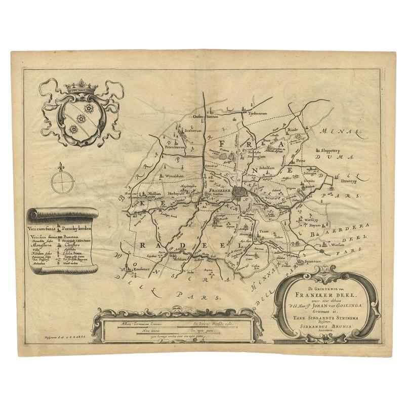
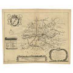
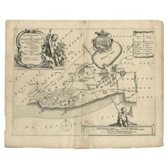
Rare Antique Map of the Region of Franekeradeel, The Netherlands 1664
About the Item
Antique map titled 'De Grietenije van Franeker deel (..)'. Map of the Grietenij of Franekeradeel, Friesland, The Netherlands. Multiple cartouches, key and coat of arms. Originates from "Beschrijvinge ende nieuwe caerten van de Heerlyckheydt van Frieslandt (…).", by Schotanus a Sterringa, first published in 1664.
Artists and Engravers: Bernardus Schotanus a Sterringa (1640-1704) was a Dutch / Frisian cartographer from Franeker.
Condition: Fair, repair on foldin line. Small tears, also affecting image. General age-related toning, some wear and creasing. Blank verso, please study image carefully.
Date: 1664
Overall size: 36.5 x 30 cm.
Image size: 36.5 x 27.5 cm.
We sell original antique maps to collectors, historians, educators and interior decorators all over the world. Our collection includes a wide range of authentic antique maps from the 16th to the 20th centuries. Buying and collecting antique maps is a tradition that goes back hundreds of years. Antique maps have proved a richly rewarding investment over the past decade, thanks to a growing appreciation of their unique historical appeal. Today the decorative qualities of antique maps are widely recognized by interior designers who appreciate their beauty and design flexibility. Depending on the individual map, presentation, and context, a rare or antique map can be modern, traditional, abstract, figurative, serious or whimsical. We offer a wide range of authentic antique maps for any budget.
- Dimensions:Height: 11.82 in (30 cm)Width: 14.38 in (36.5 cm)Depth: 0 in (0.01 mm)
- Materials and Techniques:
- Period:
- Date of Manufacture:1664
- Condition:
- Seller Location:Langweer, NL
- Reference Number:
About the Seller
5.0
Platinum Seller
These expertly vetted sellers are 1stDibs' most experienced sellers and are rated highest by our customers.
Established in 2009
1stDibs seller since 2017
1,914 sales on 1stDibs
Typical response time: <1 hour
- ShippingRetrieving quote...Ships From: Langweer, Netherlands
- Return PolicyA return for this item may be initiated within 14 days of delivery.
More From This SellerView All
- Antique Map of the Region of Franekeradeel, Friesland, The Netherlands, 1664Located in Langweer, NLAntique map titled 'De Grietenije van Franeker deel (..)'. Map of the Grietenij of Franekeradeel, Friesland, The Netherlands. Multiple cartouches, key and coat of arms. Originates fr...Category
Antique 17th Century Maps
MaterialsPaper
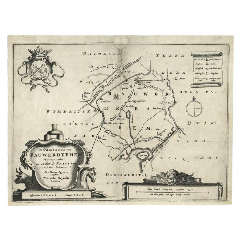
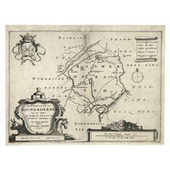
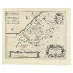
- Antique Map of the Region of Rauwerderhem, Friesland, The Netherlands, '1664'By B. SchotanusLocated in Langweer, NLAntique map titled 'De Grietenije van Rauwerderhem (..).' Map of the Grietenij of Rauwerderhem, Friesland, The Netherlands. Multiple cartouches, key and coat of arms. This map orgini...Category
Antique 17th Century Maps
MaterialsPaper
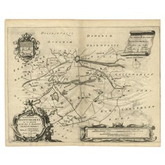
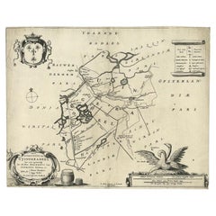
- Antique Map of the Region of Dantumadeel, Friesland, The Netherlands, 1664Located in Langweer, NLAntique map titled 'De Grietenije van Dantuma deel (..)'. Map of the Grietenij of Dantumadeel, Friesland, The Netherlands. Multiple cartouches, key and coat of arms. Originates from ...Category
Antique 17th Century Maps
MaterialsPaper
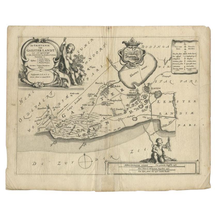
- Antique Map of the Region of Gaasterland, Friesland, The Netherlands, 1664Located in Langweer, NLAntique map titled 'De Grietenie van Gaesterlandt (..)'. Map of the region of Gaasterland in Friesland, the Netherlands. This region includes the villages of Balk, Sloten, Wyckel and...Category
Antique 17th Century Maps
MaterialsPaper
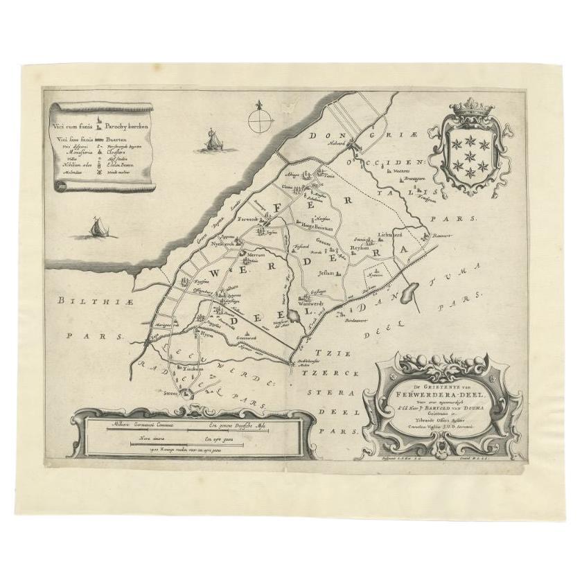
- Antique Map of the Region of Ferwerderadeel in The Netherlands, 1664Located in Langweer, NLAntique map titled 'De Grietenye van Ferwerdera-Deel (..)'. Map of the Grietenij of Ferwerderadeel, Friesland, The Netherlands. Originates from "Beschrijvinge ende nieuwe caerten van...Category
Antique 17th Century Maps
MaterialsPaper
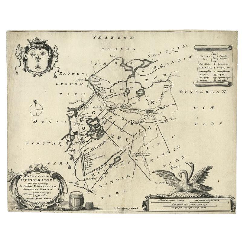
- Antique Map of the Region of Utingeradeel in Friesland, The Netherlands, 1664By B. SchotanusLocated in Langweer, NLAntique map titled 'De Grietenye van Utingeradeel (..)'. Map of the Grietenij of Utingeradeel, Friesland, The Netherlands. Multiple cartouches, key and coat of arms. "Beschrijvinge e...Category
Antique 17th Century Maps
MaterialsPaper
You May Also Like
- Original Antique Map of The Netherlands, Sherwood, Neely & Jones, Dated 1809Located in St Annes, LancashireGreat map of The Netherlands Copper-plate engraving by Cooper Published by Sherwood, Neely & Jones. Dated 1809 Unframed.Category
Antique Early 1800s English Maps
MaterialsPaper
- 1594 Maurice Bouguereau Map of the Region Limoges, France, Ric0015Located in Norton, MA1594 Maurice Bouguereau map of the region Limoges, France, entitled "Totivs Lemovici et Confinium Pro Uinciarum Quantum ad Dioecefin Lemo Uicenfen Fpectant," Hand Colored Ric0015 Jean IV Le Clerc...Category
Antique 16th Century Dutch Maps
MaterialsPaper
- School Chart or Pull Down Map of Geography of the Netherlands, 1950sLocated in Hemiksem, VANA beautiful old school map of the Netherlands, painted on linen. The map shows the 3 different reliefs (low, middle, high) of the Netherlands. The beau...Category
Vintage 1950s Belgian Mid-Century Modern Maps
MaterialsLinen, Paint
- Super Rare Antique French Map of Chine and the Chinese Empire, 1780Located in Amsterdam, Noord HollandSuper Rare Antique French Map of Chine and the Chinese Empire, 1780 Very nice map of Asia. 1780 Made by Bonne. Additional information: Type: Map ...Category
Antique 18th Century European Maps
MaterialsPaper
- 1861 Topographical Map of the District of Columbia, by Boschke, Antique MapLocated in Colorado Springs, COPresented is an original map of Albert Boschke's extremely sought-after "Topographical Map of the District of Columbia Surveyed in the Years 1856 ...Category
Antique 1860s American Historical Memorabilia
MaterialsPaper
- 1752 Vaugoundy Map of Flanders : Belgium, France, and the Netherlands, Ric.a002Located in Norton, MALarge Vaugoundy Map of Flanders: Belgium, France, and the Netherlands Colored -1752 Ric.a002 Description: This is a 1752 Didier Robert de Vaugondy map of Flanders. The map de...Category
Antique 17th Century Unknown Maps
MaterialsPaper


Recently Viewed
View AllMore Ways To Browse
Authentic Antique Keys
Antique Map Of Australia
Antique Australian Map
Antique Australian Maps
Antique Furniture In The Philippines
Antique Map Japan
Antique Filipino
Large Framed Antique Maps
Antique Baltic
Political Map
Map Of Ireland
Ireland Map
Irish Map
Captain Cook
Large Antique City Maps
Norwegian Antiques
Map Of Mexico
Antique Furniture South Australia