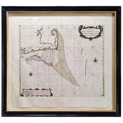
Roggeveen's Hand Colored Chart of Cape Cod and the Islands, 1675
View Similar Items


Want more images or videos?
Request additional images or videos from the seller
1 of 9
Roggeveen's Hand Colored Chart of Cape Cod and the Islands, 1675
About the Item
- Creator:Arent Roggeveen (Artist)
- Dimensions:Height: 25 in (63.5 cm)Width: 28 in (71.12 cm)Depth: 1 in (2.54 cm)
- Style:Other (Of the Period)
- Materials and Techniques:
- Place of Origin:
- Period:1670-1679
- Date of Manufacture:1675
- Condition:
- Seller Location:Nantucket, MA
- Reference Number:Seller: AD-BG-41stDibs: LU903910400923
About the Seller
5.0
Platinum Seller
These expertly vetted sellers are 1stDibs' most experienced sellers and are rated highest by our customers.
1stDibs seller since 2010
Typical response time: 1 hour
More From This SellerView All
- Hand Colored Photograph of Nantucket Street Scene by Marshall Gardiner, Ca 1910Located in Nantucket, MAAntique Hand Colored Photograph of Nantucket Street Scene by Marshall Gardiner (1884-1942), circa 1910, a period hand tinted photograph entitled "Nantucket Shearing Cart and Quakers" showing classic grey shingled houses on a cobblestone paved street, with a couple in horse drawn cart riding away from the viewer, and four women on doorstep and sidewalk, all dressed in period Quaker attire. It is interesting to note that the couple in cart are seated on antique Nantucket Bow Back Windsor chairs. The photograph was titled and hand signed in pencil across the bottom of the old acid foxed mat; the photograph is now mounted in new archival acid free matting, and a photocopy of the original pencil inscription has been preserved on the reverse. The photograph itself remains in excellent condition. H. Marshall Gardiner (1884-1942) was born on September 18, 1884 in Windsor, Ontario, and immigrated to the United States circa 1890, where his father W.H. Gardiner opened two photographic studios, one in Detroit during the winter months and a second at Mackinac Island during the more tourist-oriented summer months. Recognizing the potential of Florida's rapidly growing tourist trade, around 1894-95 he moved with his family from Detroit to Daytona, Florida which proved much more accommodating to the family's photographic business during the colder winter months. Marshall learned many of his photographic techniques from his father prior to going out on his own at a relatively early age. Whereas his father generally used wet collodian negatives, technology had advanced to where he was able to use gelatin dry plates in his earlier years, and later the less expensive and much more convenient roll film. Another very important lesson learned from his father was strategy of setting up shop in a tourist resort. Early in his career he traveled to Bermuda where he shot a series of beautiful Bermuda scenes that he hand-colored and successfully sold over a number of years to the local tourist trade. Around 1910, at the age of around 24, he first traveled to the island of Nantucket. The year-round population of Nantucket was then just over 2500, not nearly enough to sustain a photographic business for the entire year, so he opened a joint Photography and Art Supplies Store. Working as Nantucket's exclusive agent for Eastman Kodak, his business expanded to include the island's only photo-finishing service. However, with such a small year-round population, even the addition of a Gift Shop to compliment the hand-painted photographs, general portrait...Category
Early 20th Century American Other Photography
MaterialsPaper
- U.S. Navy Steel and Brass Quadrant, First Half of the 20th CenturyLocated in Nantucket, MAAntique steel and brass quadrant, first half of the 20th century, made in London for the U.S. Navy, in very good condition with lenses, shades and scale. The essential mariner's navi...Category
Early 20th Century English Other Nautical Objects
MaterialsBrass, Steel
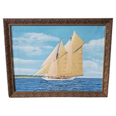
- Seascape with Portrait of a Schooner-Rigged Yacht, Signed and Dated 1937Located in Nantucket, MAEarly Vintage Seascape with Portrait of a Schooner-Rigged Yacht, signed and dated Carl Schroeder, 1937, an un-tutored oil on canvas seascape painting with a port side view of a large schooner rigged racing yacht with all canvas aloft including topsails and staysails, smartly uniformed crew, captain and first mate visible on deck, a lookout posted on the foremast crosstrees, a burgee, pennant and flag flying on the fore and main peaks, with a one design class designation A-1 on the mainsail; a low-lying spit of land with red and white cottages is visible near in background beyond the bowsprit; signed and dated Carl Schroeder, 1937 in the lower right. The painting is in near excellent condition, with only a stretcher line visible down the left side and one small pin hole on the right side. The painting is mounted in a contemporary carved an gilded frame. The artist has not been identified, but the style and subject is consistent with either the American or Danish schools. The 1930s was a golden age decade for the J-Boats and other great ocean racing yachts. The A class designation suggests very large...Category
Vintage 1930s Danish Other Paintings
MaterialsCanvas
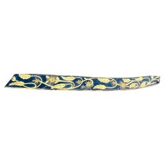
- 19th Century Hand Carved Ship's Carved and Gilded TrailboardLocated in Nantucket, MA19th Century Hand Carved Ship's Carved and Gilded Trailboard, Second Half 19th Century, a carved and shaped plaque that is upswept and narrowing towards th...Category
Antique 19th Century American Folk Art Nautical Objects
MaterialsWood
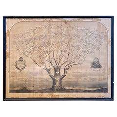
- 19th Century Mayhew Family Tree from Nantucket and Martha's Vineyard from 1855Located in Nantucket, MAVery rare 19th century Mayhew Family tree from Nantucket and Martha's Vineyard, lithograph on paper laid on linen, printed in 1855, in form of liter...Category
Antique 1850s American Other Historical Memorabilia
MaterialsPaper, Linen
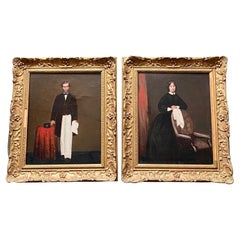
- 19th Century China Trade Pair of Portraits of Sea Captain and WifeLocated in Nantucket, MA19th Century China Trade Pair of Portraits of Sea Captain and Wife, circa 1850s, matched pair of Chinese Export oil on canvas full length portraits of a Sea Captain and his wife, painted on commission in Hong Kong or a related China Trade port. The captain wears a double breasted wool greatcoat over a high collar white shirt with bow tie, black waistcoat...Category
Antique 1850s Hong Kong Victorian Paintings
MaterialsCanvas


You May Also Like
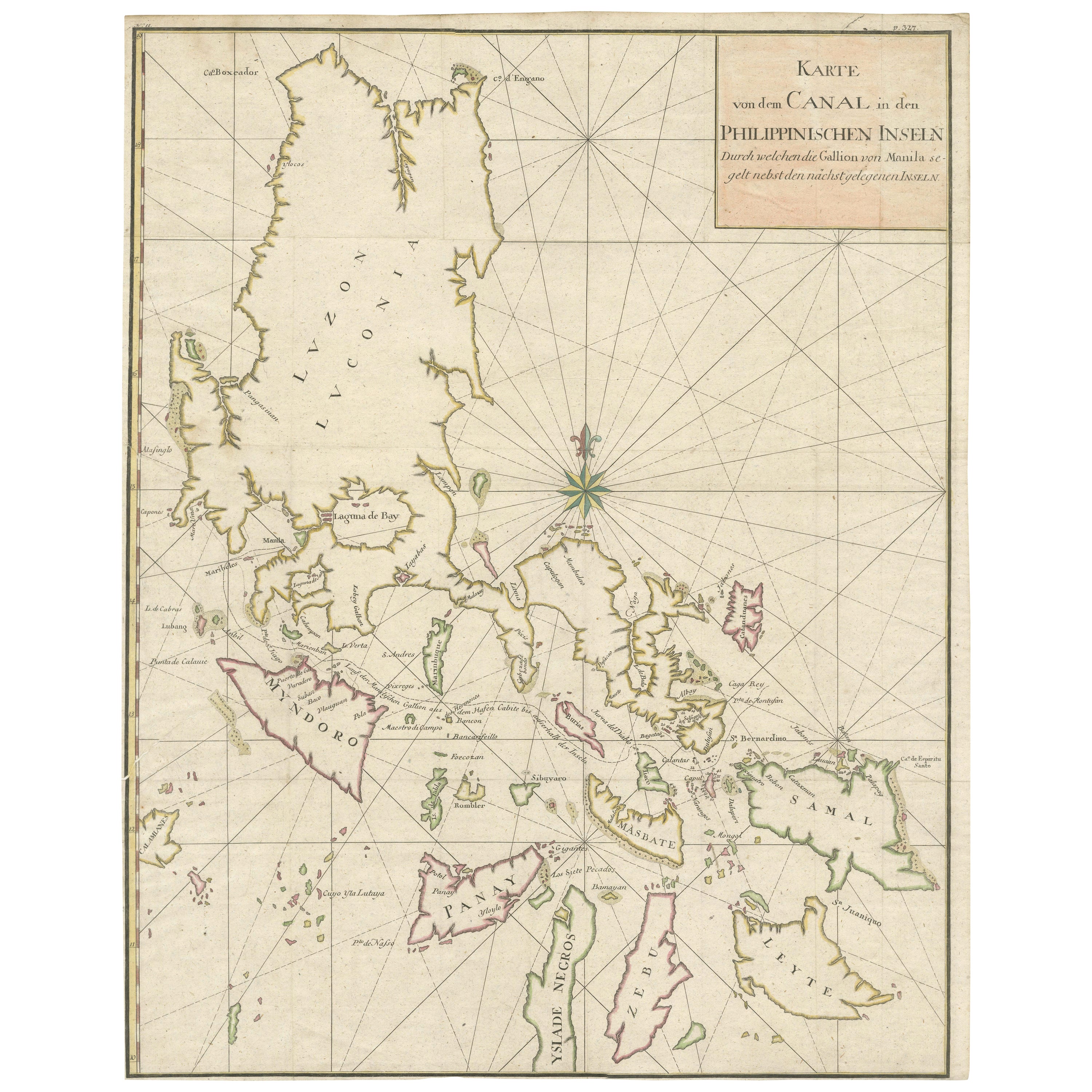
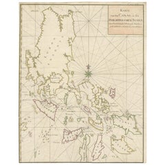
- Large German Chart of the Islands of the Philippines with Hand-Colored BordersLocated in Langweer, NLOriginal antique map titled 'Karte von dem Canal in den Philippinischen Inseln (..)'. Large detailed chart of the islands of the Philippines. One of the most detailed charts of the Philippines of the era. Shows Islands, bays, reefs, soundings tracks of the Manila Galleon route, etc. Includes a large compass rose and rhumb lines. Originates from a German edition of "Voyage around the World...Category
Antique Mid-18th Century Maps
MaterialsPaper
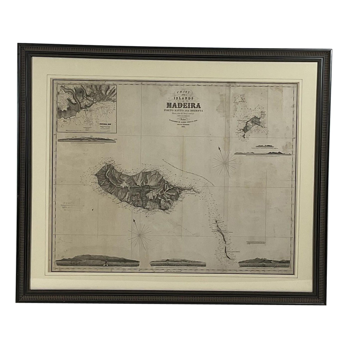
- 1865 Chart of the Islands of MadeiraLocated in Norwell, MARare James Imray chart from 1865 titled "Chart of the Islands of Madeira, Porto Santo and Dezerea" drawn from the survey made by Captain Ate Vidal Royal Navy, London. Published by Ja...Category
Antique 1860s European Maps
MaterialsPaper
- Large Chart of the island and sea of Java, IndonesiaLocated in Langweer, NLAntique map titled 'Carte Esférica de la Isla Y Mar de Java'. Large chart of the island and sea of Java, Indonesia. Beautiful nautical chart, published 1863 in Spain.Category
Antique Mid-19th Century Maps
MaterialsPaper
- Antique Chart of the Banda Islands or The Spice Islands, Indonesia, 1726Located in Langweer, NLAntique map titled 'Nieuwe Caart der Eylanden van Banda'. Beautiful chart of the Banda Islands including Banda Api, Banda Neira, Banda Besar, Pulau Hatta (Rosengain), Pulau Ai an...Category
Antique 1720s Maps
MaterialsPaper
 $601 Sale Price20% Off
 - Large Sea Chart of the British Islands, 1918Located in Langweer, NLAntique map titled 'The British Islands'. Large sea chart of the British Islands. It shows Ireland, Scotland, England, the Shetland Islands and part of Fra...Category
Vintage 1910s Maps
MaterialsPaper
 $488 Sale Price20% Off
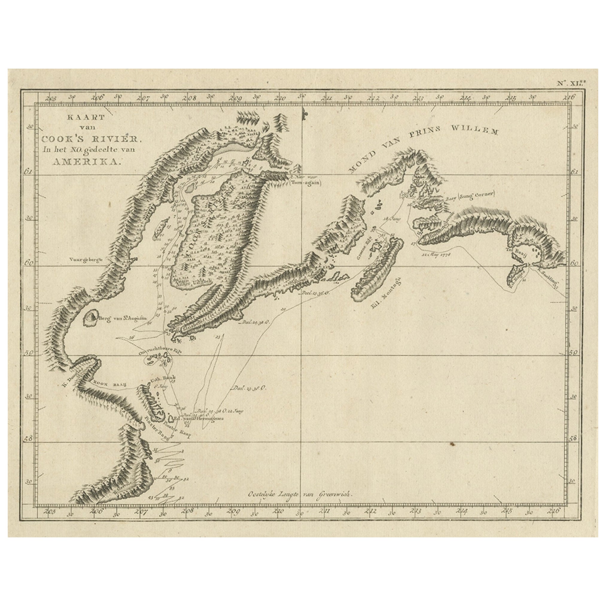
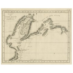
 - Original Chart Showing the Region between Cape Grenville and Cape Suckling, 1803Located in Langweer, NLAntique map titled 'Kaart van Cook's Rivier in het N.O. gedeelte van Amerika'. Chart showing the region between Cape Grenville and Cape Suckling, including Whitsuntide Bay, Cape Whitsunday, Smokey Bay, Cape Douglas, Mount St. Augustine, Volcano Mountain, R. Turn-again, Cook's River, Point Possession, Anchor Point, Point Beale Cape Elizabeth...Category
Antique Early 1800s Maps
MaterialsPaper


Recently Viewed
View AllMore Ways To Browse
Antique Pilot
Hand Painted Antique Map
Sea Chart
Antique Island Caribbean
Cape Cod Antique
Antique Map Art Collectibles
Antique Maps Art Collectibles
Map New Holland
Maritime Map
Nantucket Ship
Sea Chart Map
East Africa Map
Antique Furniture Cape Cod
Dutch Caribbean
Map New Amsterdam
Cape Dutch Furniture
Old Antique Curiosity Shop
Antique Navigation Map