Items Similar to Stunning Large Scale Antique Map of Martinique, Rare, Published 1758

Want more images or videos?
Request additional images or videos from the seller
1 of 5
Stunning Large Scale Antique Map of Martinique, Rare, Published 1758
About the Item
Antique map titled 'Carte Reduite de l'Isle de la Martinique Dressee au Depost des Cartes Plans et Journaux de la Marine.'
Superb, large scale chart of the island Martinique filled with incredible detail. It shows roads, topography, soundings, villages, windmills, and plantations. An large inset "Plan du Cul de Sac Royal de la Martinique" is surrounded by a rococo cartouche, balanced by the floral title cartouche in the opposite corner. Rhumb lines and a compass rose complete the composition. Its meticulous topographical and nautical detail makes this one of the major 18th century maps of Martinique. Source unknown, to be determined.
Artists and Engravers: Jacques Nicolas Bellin (1703-1772): French cartographer and engeneer with the Departement de la Marine. Jacques Nicolas Bellin worked for the Depot des Cartes et Plans de la Marine over fifty years. In 1741 he was appointed ingenieur hydrographe de la Marine. Later Bellin become 'Hidrographe du Roy' and a member of the Royal Society in London. In 1764 he published Petit Atlas Maritime in five volumes which contained several hundred maps. Among his other works are maps to l'Abbe Prevost's Histoire Generale des Voyages (1746-1757). Bellin also produced many accurate and finely engraved separately issued maps.
Artist: Jacques Nicolas Bellin (1703-1772): French cartographer and engeneer with the Departement de la Marine. Jacques Nicolas Bellin worked for the Depot des Cartes et Plans de la Marine over fifty years. In 1741 he was appointed ingenieur hydrographe de la Marine. Later Bellin become 'Hidrographe du Roy' and a member of the Royal Society in London. In 1764 he published Petit Atlas Maritime in five volumes which contained several hundred maps. Among his other works are maps to l'Abbe Prevost's Histoire Generale des Voyages (1746-1757). Bellin also produced many accurate and finely engraved separately issued maps.
Condition: Good, given age. Edges with a few small tears, all outside image area. Soft crease lower left. Original middle fold as issued. General age-related toning and/or occasional minor defects from handling. Please study image carefully.
Date: 1758
Overall size: 91 x 59 cm.
Image size: 87.5 x 55.7 cm.
- Dimensions:Height: 35.83 in (91 cm)Width: 23.23 in (59 cm)Depth: 0 in (0.01 mm)
- Materials and Techniques:
- Period:
- Date of Manufacture:1758
- Condition:
- Seller Location:Langweer, NL
- Reference Number:
About the Seller
5.0
Platinum Seller
These expertly vetted sellers are 1stDibs' most experienced sellers and are rated highest by our customers.
Established in 2009
1stDibs seller since 2017
1,909 sales on 1stDibs
Typical response time: <1 hour
- ShippingRetrieving quote...Ships From: Langweer, Netherlands
- Return PolicyA return for this item may be initiated within 14 days of delivery.
More From This SellerView All
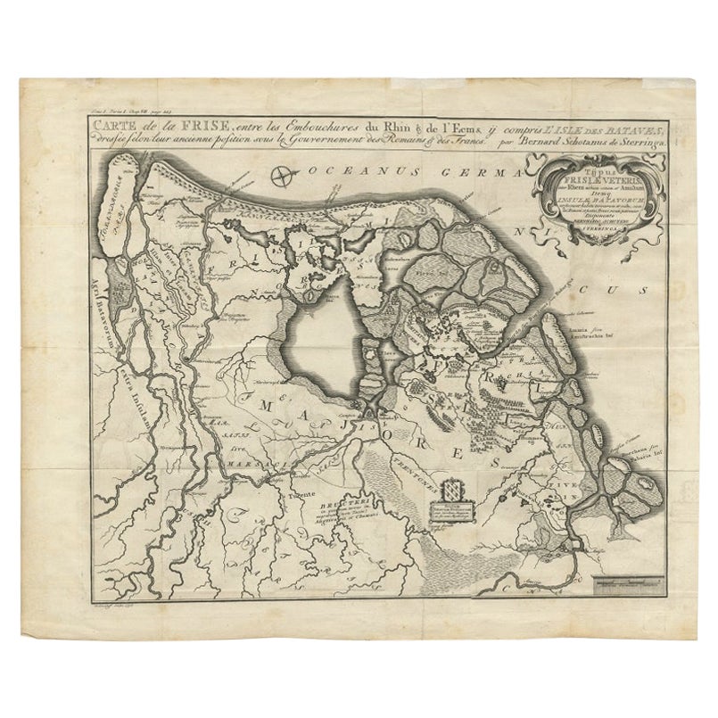
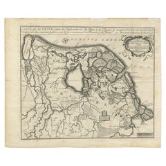
- Rare Antique Map of Friesland in Roman Times, Published 1778Located in Langweer, NLAntique map titled 'Carte de la Frise, entre les Embouchures du Rhin & de l'Eems, ij compris l'isle Bataves, dressée selon leur ancienne position le Gouvernement des Romains & des Fr...Category
Antique 18th Century Maps
MaterialsPaper
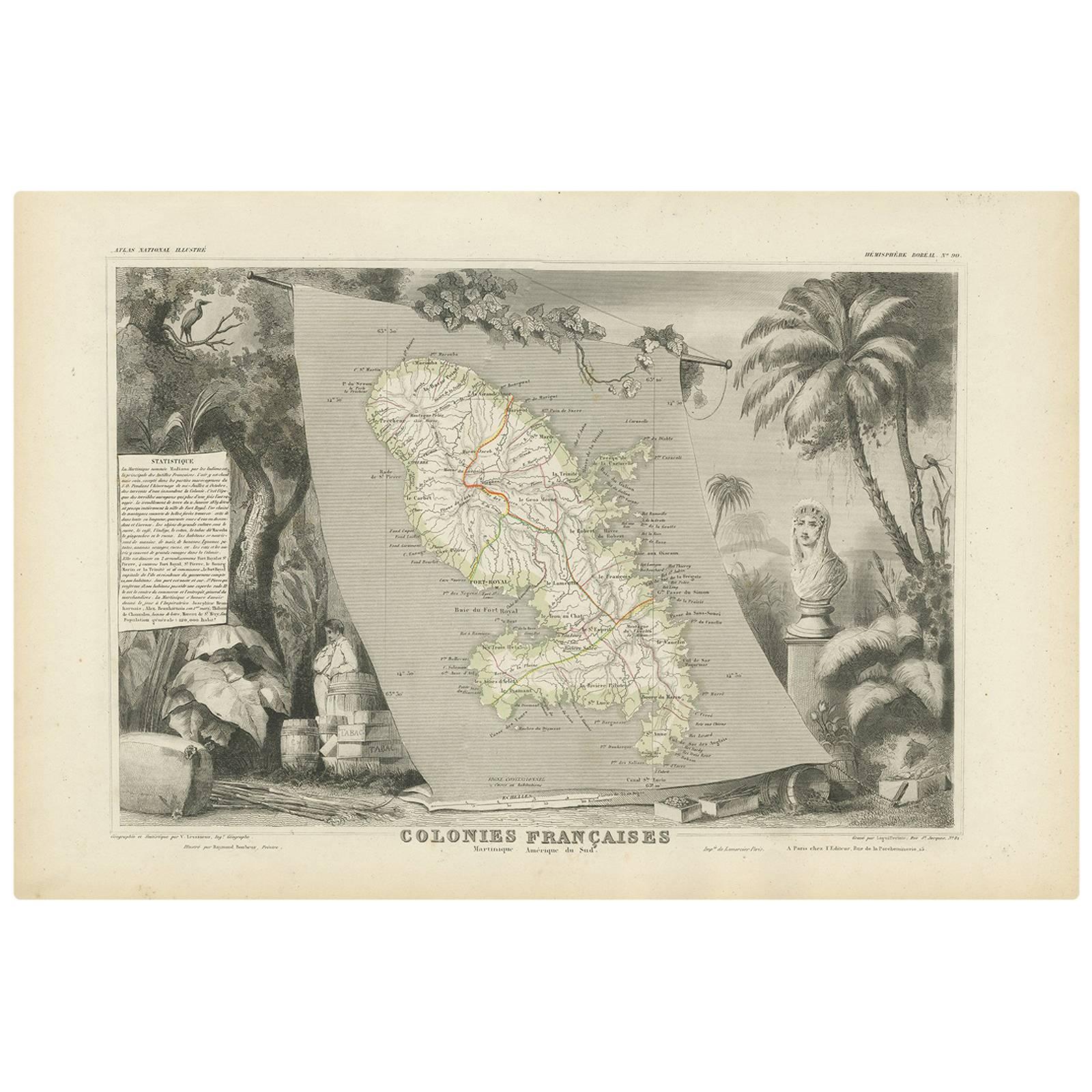
- Antique Map of the French Colony Martinique by V. Levasseur, 1854By Victor LevasseurLocated in Langweer, NLAntique map titled 'Colonies Françaises. Martinique, Amérique du Sud'. This map originates from ‘Atlas National de la France Illustré’. Published by A. Combette, Paris, 1854.Category
Antique Mid-19th Century Maps
MaterialsPaper
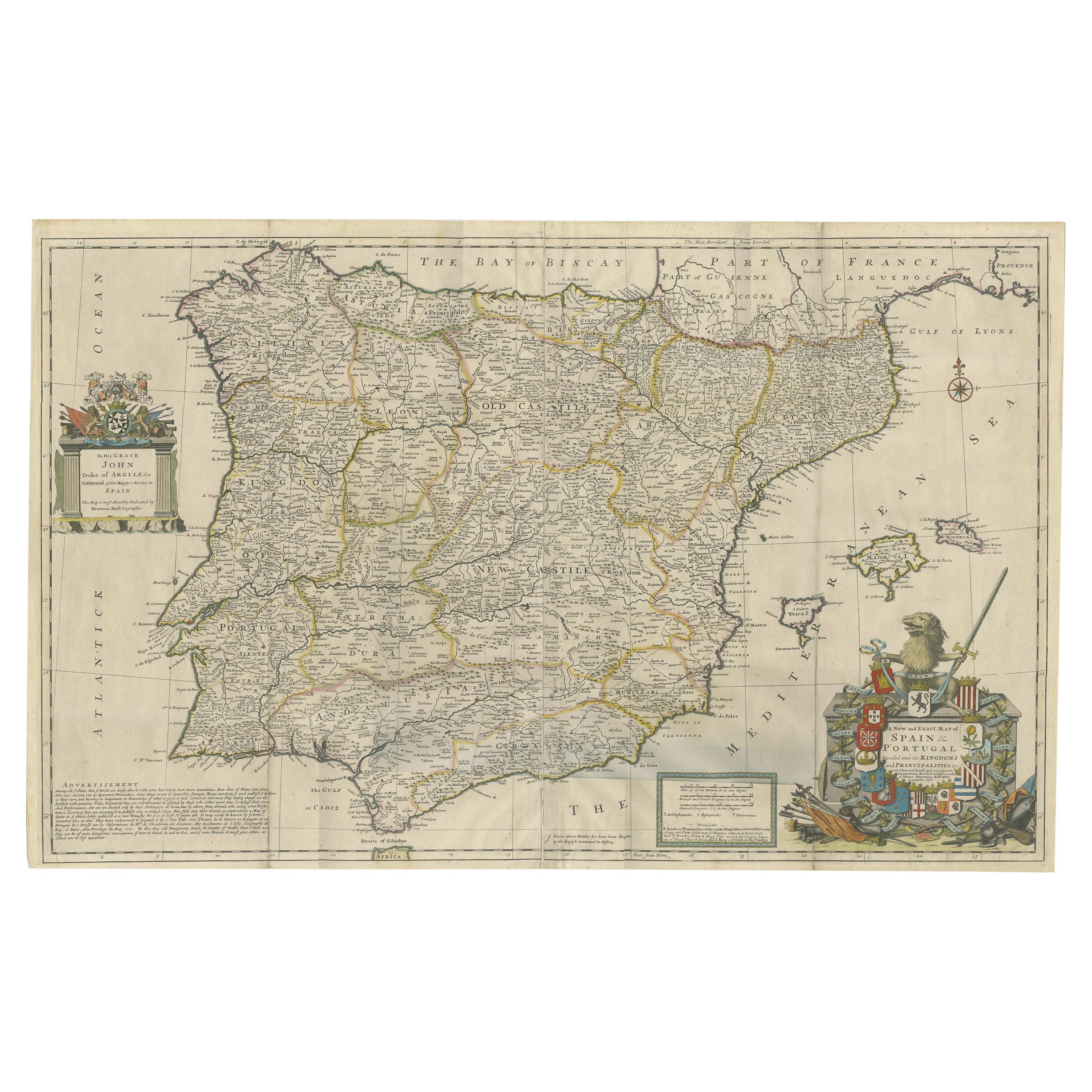
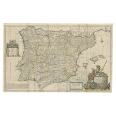
- Beautiful Large Scale Map of Spain and Portugal Published by Herman Moll in 1711Located in Langweer, NLTitle: A New and Exact Map of Spain & Portugal Author: Herman Moll Date: 1711 Medium: ?Hand-colored copperplate engraving Condition: Very good - light age toning, light wear and discoloration along issued quatrefolds, surface dirt, minor creasing throughout,. Large engraved map on two conjoined sheets, contemporary outline colouring with some later enhancement inches. Herman Moll (c. 1654-1732) was one of the most important London mapmakers in the first half of the eighteenth century. Moll was probably born in Bremen, Germany, around 1654. He moved to London to escape the Scanian Wars. His earliest work was as an engraver for Moses Pitt on the production of the English Atlas, a failed work which landed Pitt in debtor's prison. Moll also engraved for Sir Jonas Moore, Grenville Collins, John Adair, and the Seller & Price firm. He published his first original maps in the early 1680s and had set up his own shop by the 1690s. Moll's work quickly helped him become a member of a group which congregated at Jonathan's Coffee House at Number 20 Exchange Alley, Cornhill, where speculators met to trade stock. Moll's circle included the scientist Robert Hooke...Category
Antique 1710s Maps
MaterialsPaper
- Antique Map of Nova Zembla ‘Russia’ by J.N. Bellin, 1758Located in Langweer, NLAn interesting map of Nova Zembla and surrounding areas. With details on the eastern tip of Nova Zembla of the place where the stranded Dutch sailors under Willem Barentsz spent the ...Category
Antique Mid-18th Century Maps
MaterialsPaper
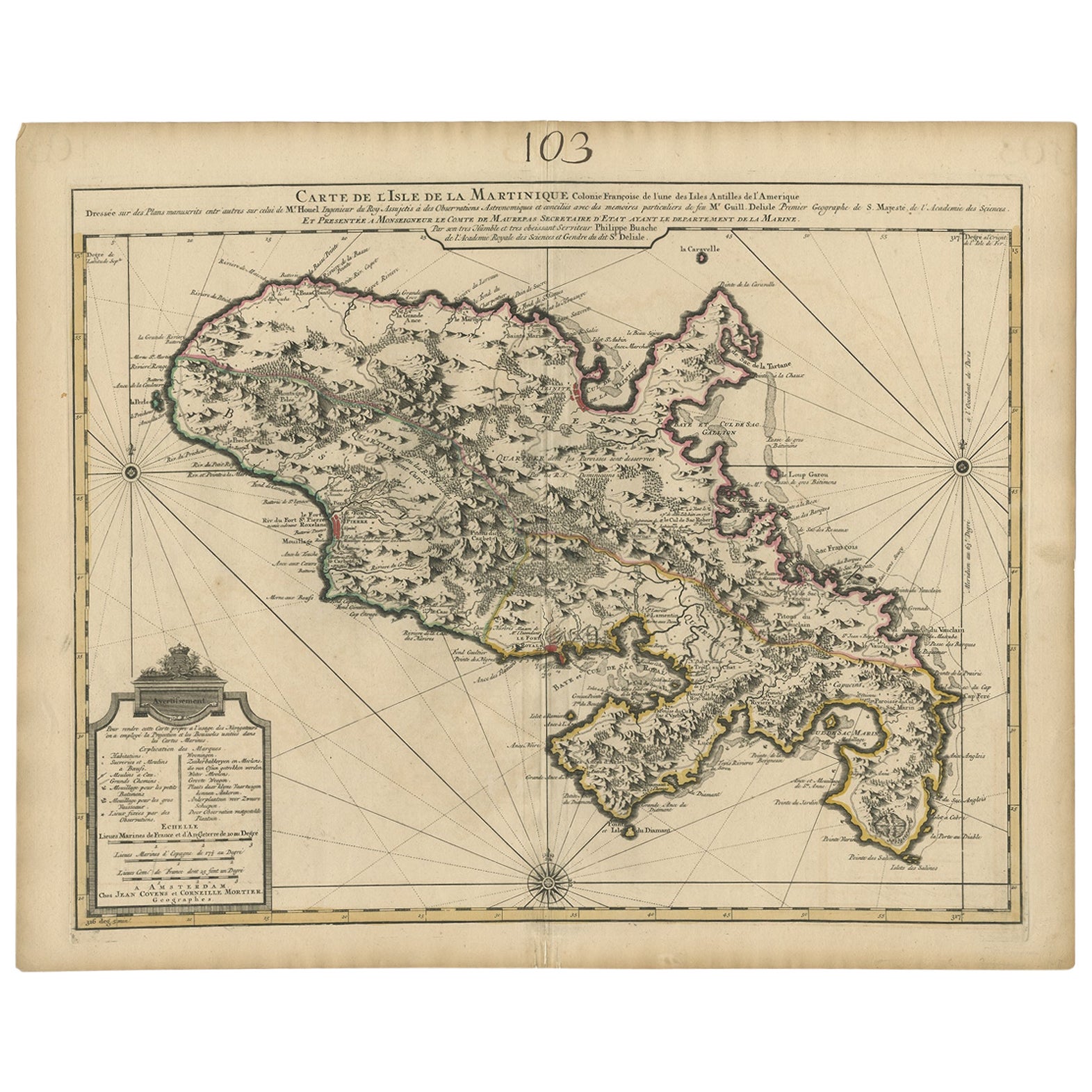
- Antique Map of Martinique, Showing Roads, Houses, Sugar Plantations, etc. c.1750Located in Langweer, NLAntique map titled 'Carte de l'Isle de la Martinique'. Detailed map of Martinique. Shows hilly terrain, forests, roads, houses, and even the sugar plantations. The island was to ...Category
Antique 18th Century Maps
MaterialsPaper
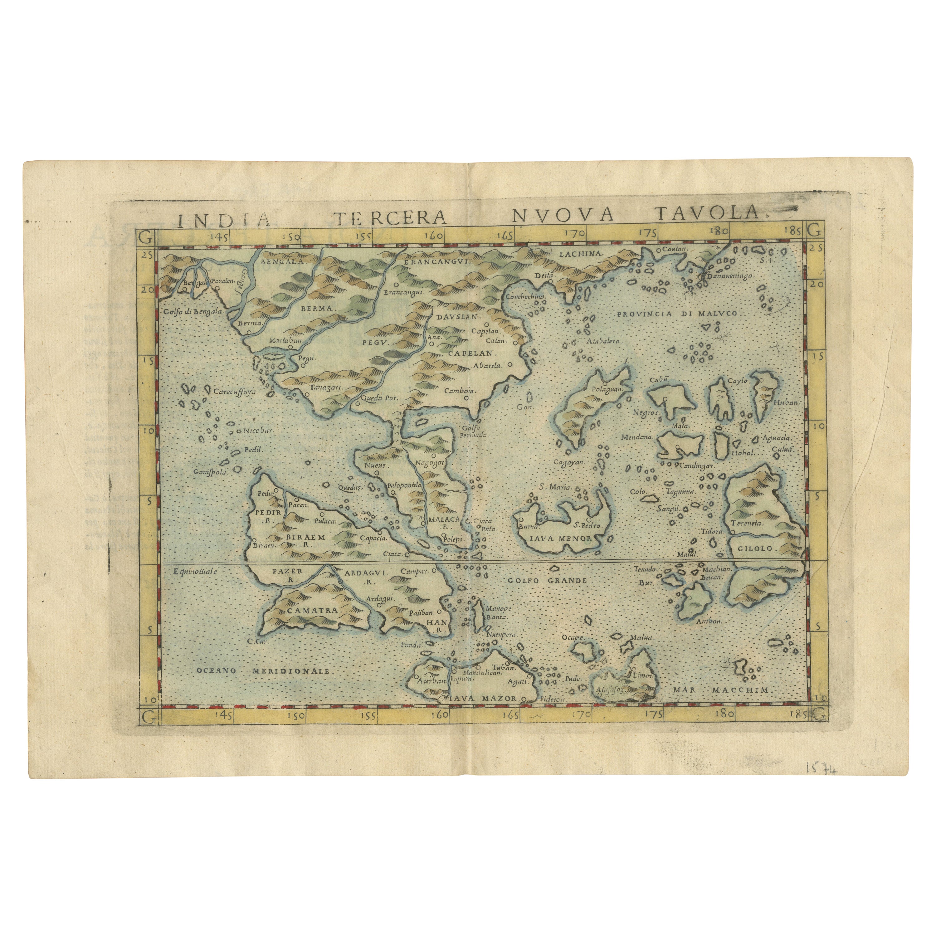
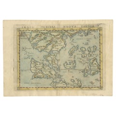
- Rare and Very Old Antique Map of South East Asia, Published circa 1574Located in Langweer, NLA very fine impression of this map of the Malay Peninsula, Sumatra, Java, with Singapore denoted as 'Cinca Pula'. Highly distorted and inaccurate map by Girolamo Ruscelli after J...Category
Antique 16th Century Maps
MaterialsPaper


You May Also Like
- Large Antique 1859 Map of North AmericaLocated in Sag Harbor, NYThis Map was made by Augustus Mitchell in 1859 It is in amazing condition for being 163 years old. This price is for the rolled up easy to ship version of this piece. I will be Frami...Category
Antique Mid-19th Century American Maps
MaterialsCanvas, Paper

- Antique Map of Principality of MonacoBy Antonio Vallardi EditoreLocated in Alessandria, PiemonteST/619 - "Old Geographical Atlas of Italy - Topographic map of ex-Principality of Monaco" - ediz Vallardi - Milano - A somewhat special edition ---Category
Antique Late 19th Century Italian Other Prints
MaterialsPaper
- Original Antique Map of Asia. C.1780Located in St Annes, LancashireGreat map of Asia Copper-plate engraving Published C.1780 Two small worm holes to right side of map Unframed.Category
Antique Early 1800s English Georgian Maps
MaterialsPaper

- Original Antique Map of Italy. C.1780Located in St Annes, LancashireGreat map of Italy Copper-plate engraving Published C.1780 Unframed.Category
Antique Early 1800s English Georgian Maps
MaterialsPaper

- Original Antique Map of India. C.1780Located in St Annes, LancashireGreat map of India Copper-plate engraving Published C.1780 Three small worm holes to right side of map and one bottom left corner Unframed.Category
Antique Early 1800s English Georgian Maps
MaterialsPaper

- Original Antique Map of Ireland- Kerry. C.1840Located in St Annes, LancashireGreat map of Kerry Steel engraving Drawn under the direction of A.Adlard Published by How and Parsons, C.1840 Unframed.Category
Antique 1840s English Maps
MaterialsPaper


Recently Viewed
View AllMore Ways To Browse
Antique And Stunning
Antique Large Island
Antique Scales Collectables
Antique Scales Collectibles
Antique Scales Collectable Scales
Scale Map
Road Map
Maritime Antiques
Large Scale Map
Topographical Map
Marine Collectibles
Marine 18th Century
Nautical Compass
Petit Antiques
Compass Map
Large Maritime
Rare Compass
La Marine Antique