Items Similar to Vintage Wall Chart of a Landscape and Geographic Map, circa 1955


Want more images or videos?
Request additional images or videos from the seller
1 of 5
Vintage Wall Chart of a Landscape and Geographic Map, circa 1955
About the Item
Vintage wall chart titled 'Kaart en Landschap'. This wall chart shows a mountain range and geographic map. Published by J.B. Wolters, circa 1955.
- Dimensions:Height: 32.68 in (83 cm)Width: 45.67 in (116 cm)Depth: 0.02 in (0.5 mm)
- Materials and Techniques:
- Period:
- Date of Manufacture:circa 1955
- Condition:Backed with linen. Shows some wear. Please study images carefully.
- Seller Location:Langweer, NL
- Reference Number:1stDibs: LU3054320873292
About the Seller
5.0
Platinum Seller
These expertly vetted sellers are 1stDibs' most experienced sellers and are rated highest by our customers.
Established in 2009
1stDibs seller since 2017
1,914 sales on 1stDibs
Typical response time: <1 hour
- ShippingRetrieving quote...Ships From: Langweer, Netherlands
- Return PolicyA return for this item may be initiated within 14 days of delivery.
More From This SellerView All
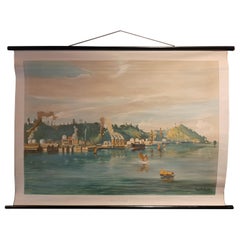
- Vintage Wall Chart of Balikpapan 'Indonesia'Located in Langweer, NLVintage wall chart titled 'Balikpapan'. View of Balikpapan, a seaport city in East Kalimantan, Indonesia. Published circa 1920. The vintage wall ch...Category
Early 20th Century Prints
MaterialsPaper
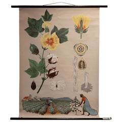
- Vintage Botany Wall Chart of a Cotton Plant and Cotton Cultivation, circa 1960Located in Langweer, NLThe vintage botany wall chart of a cotton plant and cotton cultivation by Jung, Koch, and Quentell, published around 1960, is an excellent example of educ...Category
Mid-20th Century Prints
MaterialsPaper
- Vintage Wall Chart of Australia, 1949Located in Langweer, NLVintage wall chart of Australia and surroundings. Published by R. Bos and K. Zeeman, 1949.Category
Mid-20th Century Prints
MaterialsPaper
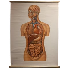
- Vintage Anatomy Wall Chart of the Upper Body, circa 1960Located in Langweer, NLVintage wall chart of the upper body. Sticker on verso reads '2008 Deutsches Hygiene Museum Dresden'. Published circa 1960.Category
Mid-20th Century Prints
MaterialsPaper
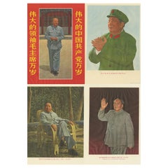
- Set of Four Vintage Mao Zedong Posters, circa 1968Located in Langweer, NLA set of propaganda photographic posters featuring well-known images of Chairman Mao. Mao Zedong, also known as Chairman Mao, was a Chinese communist...Category
Late 20th Century Prints
MaterialsPaper
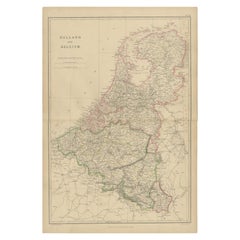
- 1859 Vintage Map of Holland and Belgium: Blackie's Imperial Geographic InsightLocated in Langweer, NLThe "Antique Map of Holland and Belgium" from 'The Imperial Atlas of Modern Geography', published by W. G. Blackie in 1859, is a significant hi...Category
Antique Mid-19th Century Maps
MaterialsPaper

You May Also Like
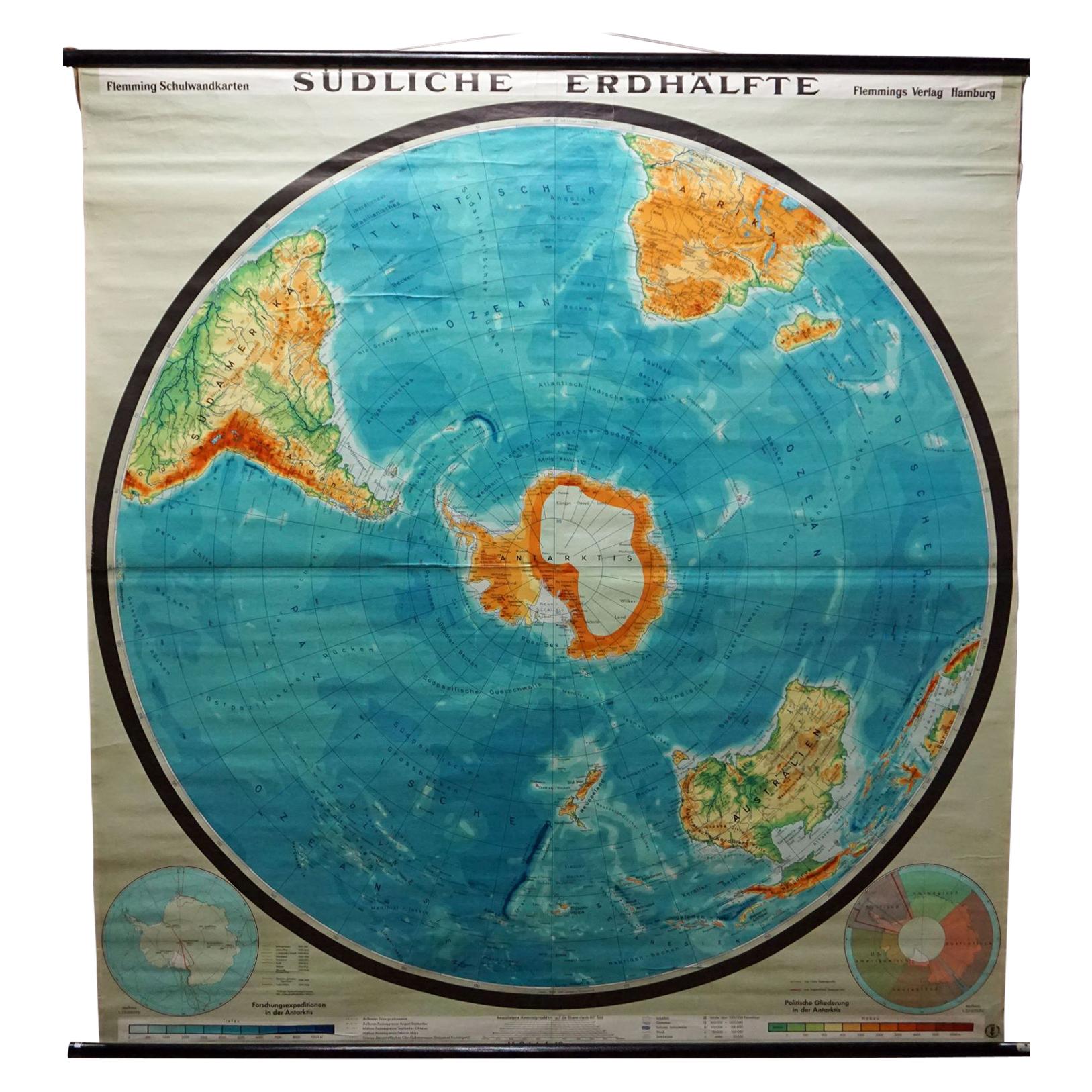
- Southern Hemisphere of the Earth Rollable Map Vintage Wall ChartLocated in Berghuelen, DEA great pull-down map or vintage wall chart illustrating the southern hemisphere of the earth, published by Prof. Dr. C. Troll, Flemmings Verlag Hamburg. Colorful print on paper rein...Category
Mid-20th Century German Country Prints
MaterialsCanvas, Wood, Paper
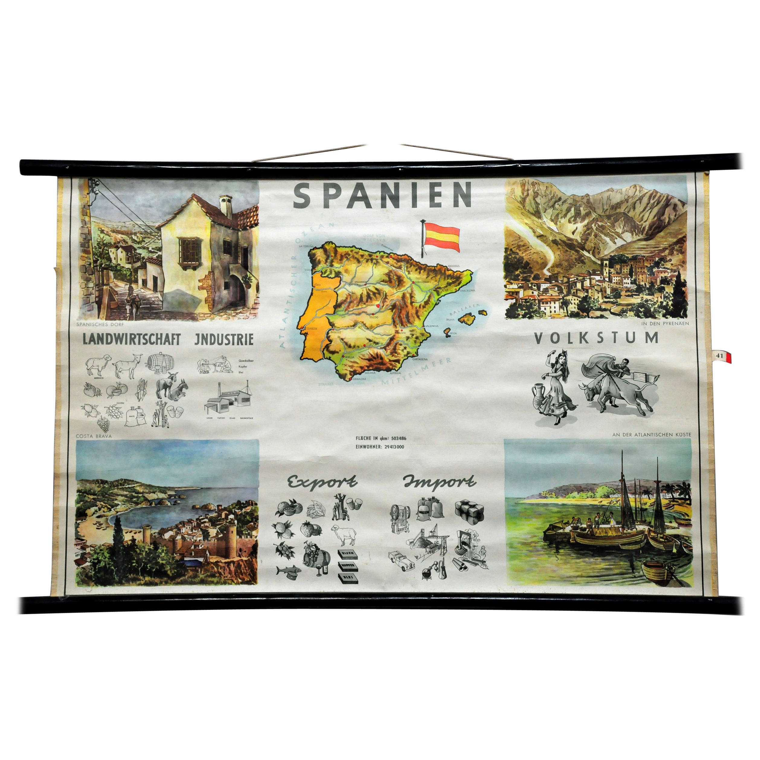
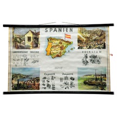
- Cottagecore Wall Chart Spain Landscape Culture Souvenir Rollable Map PosterLocated in Berghuelen, DEA countrycore vintage pull-down wall chart depicting Spain with a map and coloful pictures of citylife and countryside. Used as teaching material in German schools. colorful print on paper reinforced with canvas. published by P. Stockmann, Bochum. Perfect holiday wall decoration for all Spain...Category
Vintage 1960s German Country Prints
MaterialsCanvas, Wood, Paper
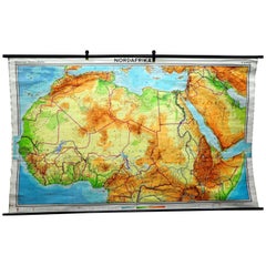
- Vintage Mural Map of North Africa Countrycore African Wall Chart DecorationLocated in Berghuelen, DEThe wall map shows North Africa. It was published by Westermann-Schulwandkarten. Used as teaching material in German schools. Colorful print on paper reinforced with canvas, Measurem...Category
Late 20th Century German Country Prints
MaterialsCanvas, Wood, Paper
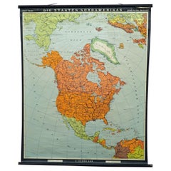
- Vintage Map Wall Chart Countries of North America Rollable Mural PosterLocated in Berghuelen, DEThe vintage pull-down school map illustrates the countries / states of North America. Published by Haack-Painke Justus Perthes Darmstadt. Colorful print on paper reinforced with canv...Category
Late 20th Century German Country Prints
MaterialsCanvas, Wood, Paper
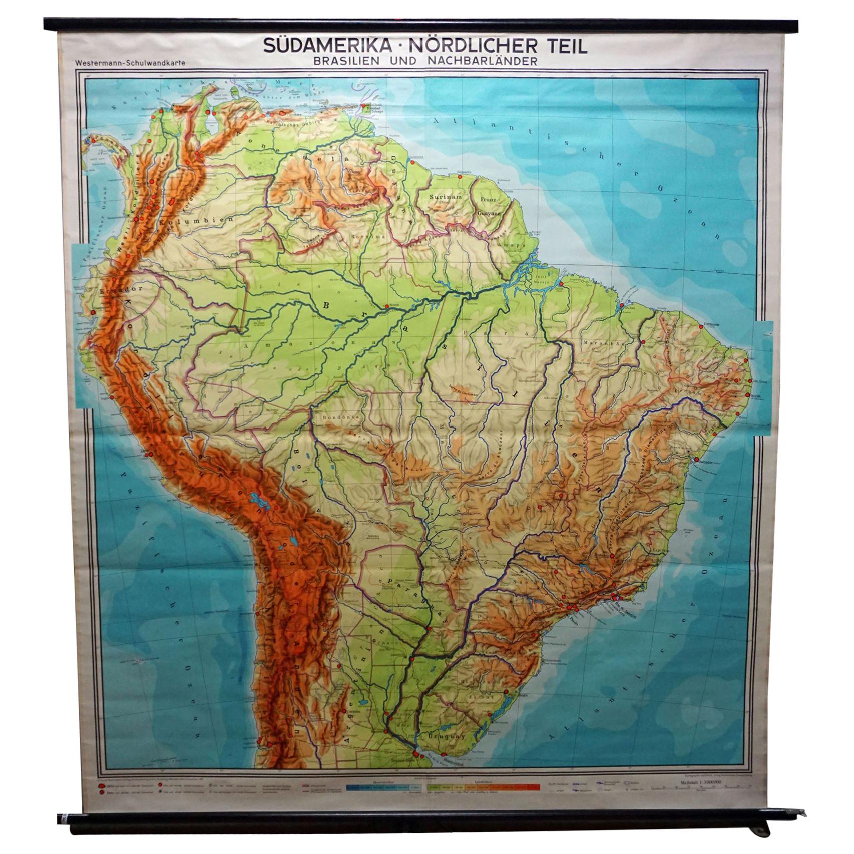
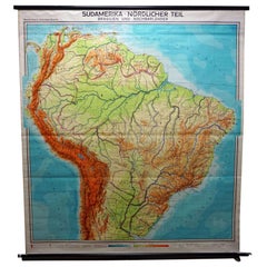
- Vintage Rollable Map Wall Chart South America Brasilia and Neighbour StatesLocated in Berghuelen, DEA classical pull-down school map showing South America with Brasilia and its neighbor states, published by Westermann. Colorful print on paper reinforced with canvas. Measurements: W...Category
Mid-20th Century German Country Prints
MaterialsCanvas, Wood, Paper
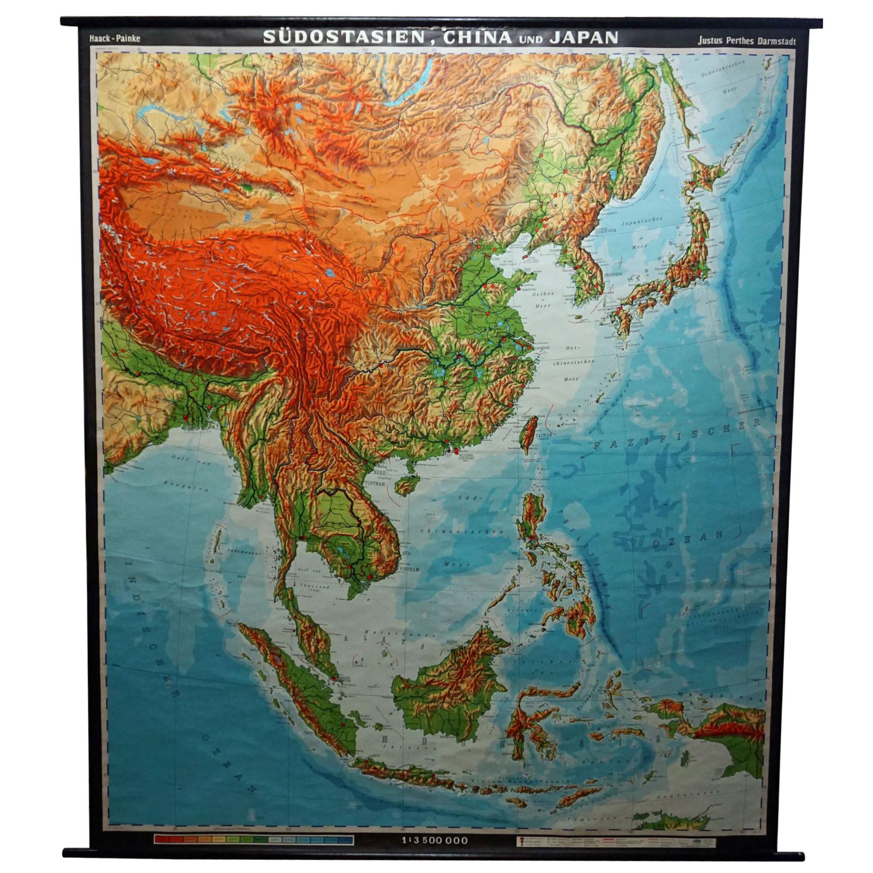
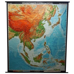
- Vintage Rollable Map Southeast Asia China Japan Wall ChartLocated in Berghuelen, DEA classical pull-down school map showing the popular region of Southeast Asia with China and Japan. Published by Haack-Painke Justus-Perthes Darmstadt. Colorful print on paper reinfo...Category
Late 20th Century German Country Prints
MaterialsCanvas, Wood, Paper

Recently Viewed
View AllMore Ways To Browse
Vintage Wall Map
Rouault Signed
Peter Max Signed Numbered
Indonesia Vintage Map
Maki Haku
Antique Radios I
Antique Vanity Fair Prints
Vintage American Diner Furniture
Louis Icart Copyright
Disney Movies
Inuit Glasses
Indian Chief Lithograph
P J Redoute
Indonesia Map Vintage
Sealife Prints
Racinet Persian
Loon Bird
La Mode Illustree