Items Similar to Personification of Fortitude as a Modestly Dressed Seated Female Figure, ca.1780


Want more images or videos?
Request additional images or videos from the seller
1 of 5
Personification of Fortitude as a Modestly Dressed Seated Female Figure, ca.1780
About the Item
Antique print, titled: 'Fortitude.' - Personification of Fortitude as a modestly dressed seated female figure. A lion in the background. From 'The Universal Magazine of Knowledge and Pleasure'. This periodical was published between 1747 and 1814, edited by John Hinton and W. Bent.
Artists and Engravers: Anonymous.
- Dimensions:Height: 8.31 in (21.1 cm)Width: 5.04 in (12.8 cm)Depth: 0 in (0.02 mm)
- Materials and Techniques:
- Period:1780-1789
- Date of Manufacture:circa 1780
- Condition:Condition: Very good, given age. Left edge a little uneven from binding. Some offsetting from letterpress text on the opposite page. General age-related toning and/or occasional minor defects from handling. Please study scan carefully.
- Seller Location:Langweer, NL
- Reference Number:
About the Seller
5.0
Platinum Seller
These expertly vetted sellers are 1stDibs' most experienced sellers and are rated highest by our customers.
Established in 2009
1stDibs seller since 2017
1,906 sales on 1stDibs
Typical response time: <1 hour
- ShippingRetrieving quote...Ships From: Langweer, Netherlands
- Return PolicyA return for this item may be initiated within 14 days of delivery.
More From This SellerView All
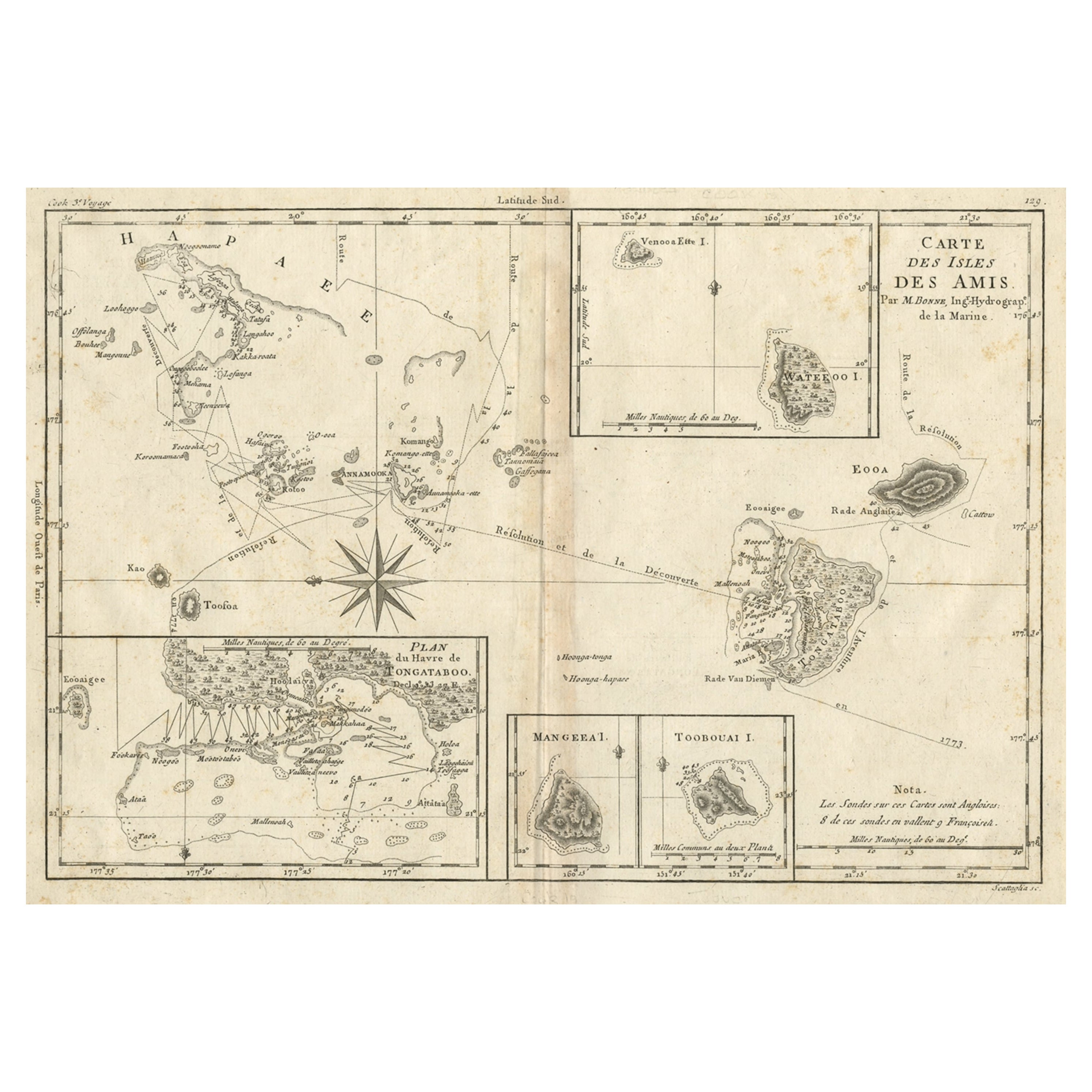
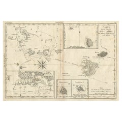
- Old Map of the Kingdom of Tonga, Also Known as the Friendly Islands, ca.1780Located in Langweer, NLAntique print, titled: 'Carte des Isles des Amis.' Map of the Kingdom of Tonga, also known as the Friendly Islands, and one of the last hereditary monarchies. Cook named this gro...Category
Antique 1780s Maps
MaterialsPaper
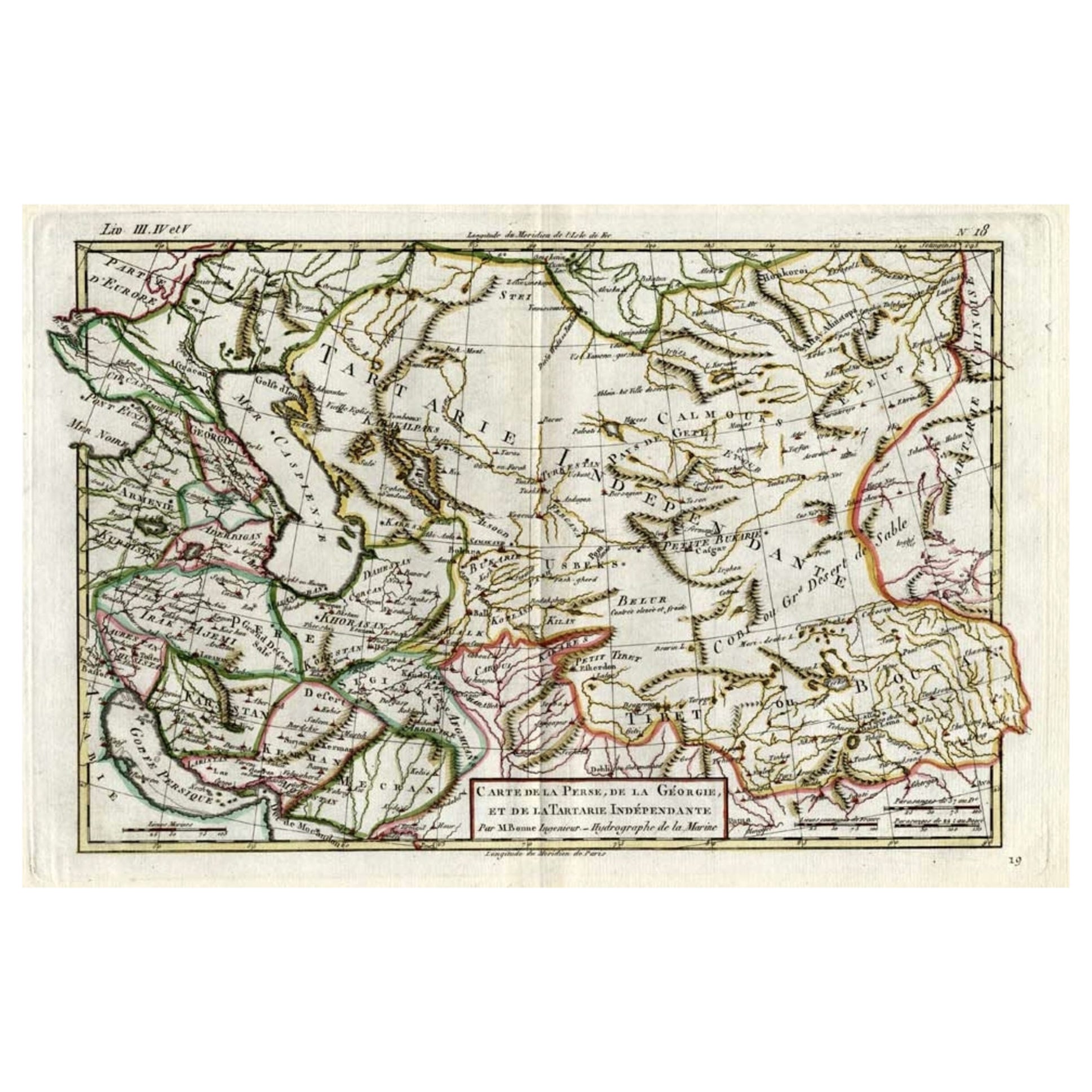
- Antique Map of Persia, Georgia and Kazakhstan, ca.1780Located in Langweer, NLAntique map titled 'Carte de la Perse, de la Georgie, et de la Tartarie Independante'. Map of Persia, Georgia and Kazakhstan. This map shows current days Georgia, Iran, Irak, Kaz...Category
Antique 1780s Maps
MaterialsPaper
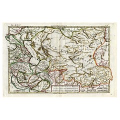
- Antique Map of the Russian Empire in Europe, ca.1780Located in Langweer, NLDescription: Antique map titled 'Bowles's New Pocket Map of the Russian Empire in Europe, Comprehending the West Part of the Empire in Asia' Large and detai...Category
Antique 1780s Maps
MaterialsPaper
- Antique Map of Northern Europe and European Russia, ca.1780Located in Langweer, NLAntique map titled 'Le Nord de L'Europe, Contenant Le Danemark, La Norwege; La Suede et La Laponie avec la Majeure Partie de al Russie Europeenne.' Map of Northern Europe and Eur...Category
Antique 1780s Maps
MaterialsPaper
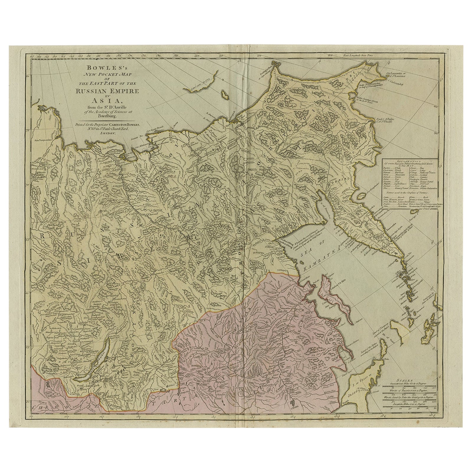
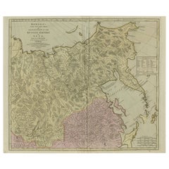
- Large and Detailed Map of the Russian Empire in Asia, ca.1780Located in Langweer, NLDescription: Antique map titled 'Bowles's New Pocket Map of the East Part of the Russian Empire in Asia'. Large and detailed map of the Russian Empire in Asia. Source unknown, to be determined. Artists and Engravers: Made by 'Thomas & Carington Bowles' after 'D'Anville'. Thomas Bowles, born around 1712, was map publisher and seller in London...Category
Antique 1780s Maps
MaterialsPaper
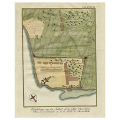
- Original Antique Plan of the Fortress of Charedsch in Persia or Iran, ca.1780Located in Langweer, NLAntique map, titled: 'Plan de la Citadelle de la Ville de Charedsch.' Plan of the fortress of Charedsch, Iran / Persia. This original antique print originates from 'Reize naar Ar...Category
Antique 1780s Maps
MaterialsPaper


You May Also Like
- Original Antique Map of Italy. C.1780Located in St Annes, LancashireGreat map of Italy Copper-plate engraving Published C.1780 Unframed.Category
Antique Early 1800s English Georgian Maps
MaterialsPaper

- Original Antique Map of Asia. C.1780Located in St Annes, LancashireGreat map of Asia Copper-plate engraving Published C.1780 Two small worm holes to right side of map Unframed.Category
Antique Early 1800s English Georgian Maps
MaterialsPaper

- Original Antique Map of India. C.1780Located in St Annes, LancashireGreat map of India Copper-plate engraving Published C.1780 Three small worm holes to right side of map and one bottom left corner Unframed.Category
Antique Early 1800s English Georgian Maps
MaterialsPaper

- Original Antique Map of South America. C.1780Located in St Annes, LancashireGreat map of South America Copper-plate engraving Published C.1780 Two small worm holes to left side of map Unframed.Category
Antique Early 1800s English Georgian Maps
MaterialsPaper
- Civil War Panorama of the Seat of War by John Bachmann, Antique Print circa 1864Located in Colorado Springs, COPanorama of the seat of war. Bird's-eye View of Virginia, Maryland, Delaware and the District of Columbia. This third state of this fascinating bird's eye view of the northernmost p...Category
Antique 1860s American Maps
MaterialsPaper
- Lithographic print on paper, depicting the atlas of the hand, France 1850 ca.Located in Milan, ITAn anatomical lithographic print on paper, depicting the anatomical atlas of the hand. Black lacquered fir wood frame with golden ramin wood batting. N. H. Ja...Category
Antique Mid-19th Century French Prints
MaterialsGlass, Wood, Paper


Recently Viewed
View AllMore Ways To Browse
Lion Dress
Antique Aubusson Tapestries
Antique Aubusson Tapestry
Designer Wallpaper
Laura Antiques
Swan Cabinet
French Display Shelf
Enamel Glass Box
Aesthetic Vintage Green
Antique Glass Cabinet Cabinets And Cupboards
Midcentury Wool Tapestry
Vintage Black Cabinet Hardware
Tapestry 1960
Antique Commode Chest Marble Top
Used Arcade
18th Century Hand Carved Doors
Chest With Ormolu
Gold Nails