Articoli simili a 1866 Ensign & Bridgman's Rail Road Map of the United States


Caricamento del video
Vuoi altre immagini o video?
Richiedi altre immagini o video al venditore
1 di 10
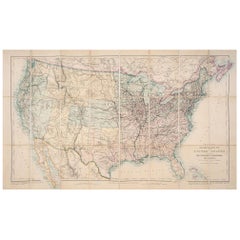
1866 Ensign & Bridgman's Rail Road Map of the United States
7420,62 €
Informazioni sull’articolo
Presented is an 1866 issue of “Ensign & Bridgeman’s Rail Road Map of the United States, showing Depots & Stations.” First published in 1856, this is the third edition, following another issued in 1859. It is an expansive and impressive 19th century map depicting the eastern half of the United States, just after the end of the Civil War. Starting on the eastern coast, the map extends to the western borders of Minnesota, Iowa, Missouri, Arkansas, and Louisiana. As alluded to in its title, the map highlights existing railroads and railroad depots, as well as proposed lines. State boundaries, county boundaries, cities, and major towns are all labeled, along with some rivers and larger lakes. At the bottom of the map is an inset map “Plan of the New England States.” A decorative title block includes a railroad racing a steam boat, topped with a large spread wing eagle. The whole is enclosed within a wide ornamental border.
The map captures the burgeoning American railway infrastructure and documents the industrial ambition of this era. In the mid-1800s, railroads were transforming the landscape of North America, revolutionizing transportation, industry, and shifting populations seemingly overnight. This map reflects this transformation by illustrating the extensive railway system, including key routes west and the criss-crossing routes one can take to travel between cities and new rail hubs.
Many names of railroads appear along the cross-hatched lines, while others are numbered to a key list of lines at the bottom right. A small notice states that the publishers were going to print small editions at a time so that reliable railroad information could be added or updated. They continue on to state that “They will feel under obligations to Contractors, Superintendents, & others, who will forward to their address reliable information respecting Proposed or Completed railroads.” The inset map focuses on the railways and depots throughout New England, where early American rail travel first flourished.
CONDITION:
Engraved map. Hand coloring to outlines. Fold lines, as originally issued. Toning along fold lines. Trimmed close to margins.
Map is archivally framed with acid-free mats, UV glass, and a custom-built wooden frame. Framed Dimensions: 45 3/4" H x 48 1/4" W x 1 1/2" D.
- Dimensioni:Altezza: 116,21 cm (45,75 in)Larghezza: 122,56 cm (48,25 in)Profondità: 3,81 cm (1,5 in)
- Stile:Tardo vittoriano (Del periodo)
- Materiali e tecniche:
- Luogo di origine:
- Periodo:
- Data di produzione:1866
- Condizioni:Usura compatibile con l’età e l’utilizzo. Framed to the highest archival standards by Art Source International Framing in Boulder, Colorado in December of 2023.
- Località del venditore:Colorado Springs, CO
- Numero di riferimento:Venditore: M3181stDibs: LU909737659882
Informazioni sul venditore
4,9
Venditore Platino
Venditori Premium con valutazione 4.7+ e tempi di risposta entro 24 ore
Fondazione nel 2010
Venditore 1stDibs dal 2011
463 vendite su 1stDibs
- SpedizioneRecupero del preventivo…Spedizione da: Colorado Springs, CO
- Politica di reso
Alcune parti di questa pagina sono state tradotte automaticamente. 1stDibs non può garantire che le traduzioni siano corrette. L’inglese è la lingua predefinita del sito.
Garanzia di autenticità
Nell’improbabile caso in cui si verifichi un problema con l’autenticità di un articolo, contattaci entro un anno per ottenere un rimborso completo. DettagliGaranzia di rimborso
Se il tuo articolo non corrisponde alla descrizione, è danneggiato durante il trasporto o non arriva, contattaci entro 7 giorni per un rimborso completo. DettagliAnnullamento entro 24 ore
Hai un periodo di tolleranza di 24 ore per annullare il tuo acquisto, senza necessità di fornire spiegazioni.Venditori professionali selezionati
I nostri venditori di livello internazionale devono aderire a rigorosi standard di servizio e qualità, garantendo l’integrità delle inserzioni.Garanzia miglior prezzo
Se scopri che un venditore ha pubblicato altrove lo stesso articolo a un prezzo più basso, applicheremo lo stesso prezzo.Consegna globale affidabile
La nostra rete di vettori leader del settore offre opzioni di spedizione specializzate in tutto il mondo, inclusa la consegna personalizzata.Altro da questo venditore
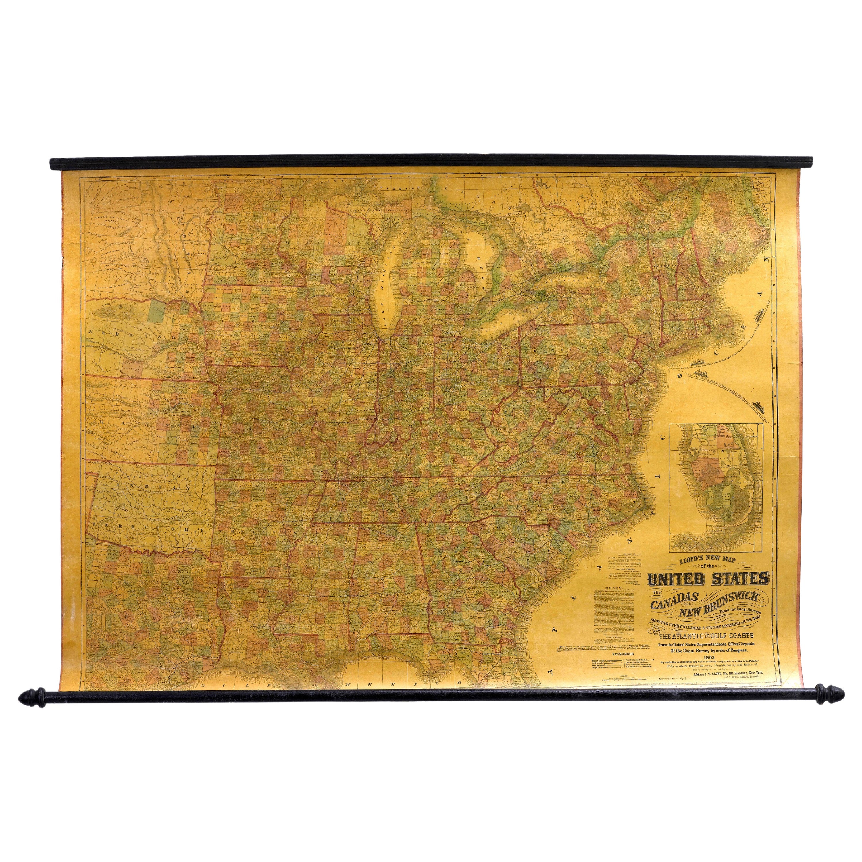
Mostra tutto1863 "Nuova mappa di Lloyd degli Stati Uniti, del Canada e del New Brunswick".
Viene presentata la "Nuova mappa di Lloyd degli Stati Uniti, del Canada e del New Brunswick, basata sugli ultimi rilievi, con tutte le ferrovie e le stazioni completate fino al giugn...
Categoria
Di antiquariato/d’epoca, Anni 1860, Americano, Mappe
Materiali
Lino, Legno, Carta

1859 "Mappa degli Stati Uniti d'America..." di J.H. Colton
Di J.H. Colton
Viene presentata una "Mappa degli Stati Uniti d'America, delle Province Britanniche, del Messico, delle Indie Occidentali e dell'America Centrale con parte della Nuova Granada e del ...
Categoria
Di antiquariato/d’epoca, Anni 1850, Americano, Mappe
Materiali
Carta

Mappa del Nord America del 1864, Carta geografica antica colorata a mano, di Adolphe Hippolyte Dufour
Viene offerta una mappa del Nord America intitolata Amerique du Nord del 1864. Questa rara mappa murale, pubblicata separatamente, è stata realizzata da Adolphe Hippolyte Dufour. Que...
Categoria
Di antiquariato/d’epoca, Anni 1860, Francese, Mappe
Materiali
Carta

Mappa da parete antica "Gli Stati Uniti dalle ultime autorità", 1835
Questa è una mappa del 1835 di "The United States from the Latest Authorities" di Ezra Strong. Mappa murale incisa a mano della metà orientale degli Stati Uniti, con un grande insert...
Categoria
Di antiquariato/d’epoca, Anni 1830, Americano, Mappe
Materiali
Carta

1868 "Carta topografica ferroviaria di Lloyds del Nord America..." Mappa da parete appesa
Viene presentata la "Mappa topografica ferroviaria di Lloyds del Nord-America, o il continente degli Stati Uniti nel 1900". Questa mappa è stata pubblicata da J. T. Lloyd, a New York...
Categoria
Di antiquariato/d’epoca, Anni 1860, Americano, Tardo vittoriano, Mappe
Materiali
Lino, Carta

Mappa "Nord America" del 1846, incisa da I. Dower
Viene presentata una mappa originale del 1846 del "Nord America". La mappa è stata disegnata e incisa da I. Dower e pubblicata a Londra da Orr & Company. La mappa raffigura il Nord A...
Categoria
Di antiquariato/d’epoca, Anni 1840, Inglese, Vittoriano, Mappe
Materiali
Carta

Ti potrebbe interessare anche
Carta ferroviaria antica degli Stati Uniti di Rand, McNally & Co., 1900
Carta geografica antica intitolata "Rand, McNally & Co. New Official Railroad map of the United States with portions of The Dominion of Canada, The Republic of Mexico and the West In...
Categoria
XX secolo, Mappe
Materiali
Lino, Carta

1875 € Prezzo promozionale
25% in meno
Spedizione gratuita
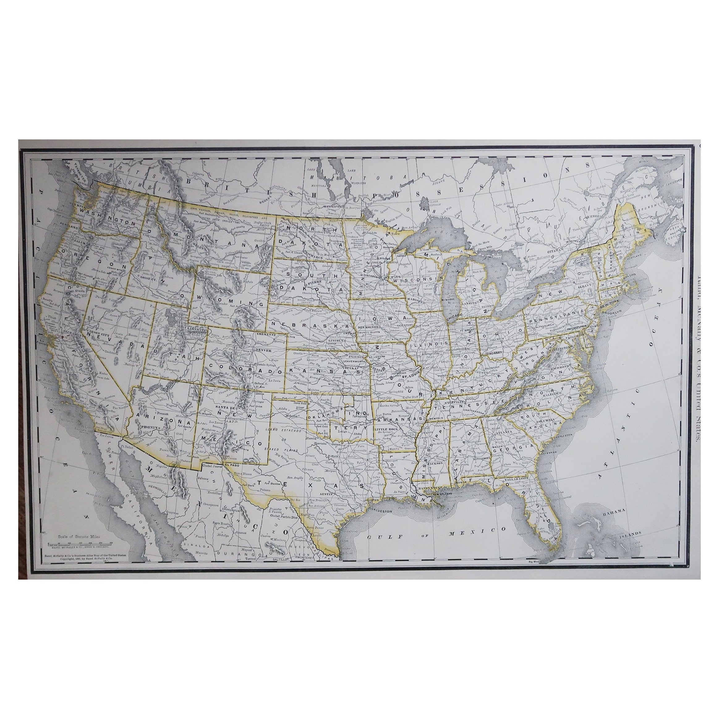
Grande mappa originale degli Stati Uniti d'America. 1891
Di Rand McNally & Co.
Favolosa mappa degli Stati Uniti
Colore originale
Da Rand, McNally & Co.
Datato 1891
Non incorniciato
Spedizione gratuita.
Categoria
Di antiquariato/d’epoca, Anni 1890, Americano, Mappe
Materiali
Carta

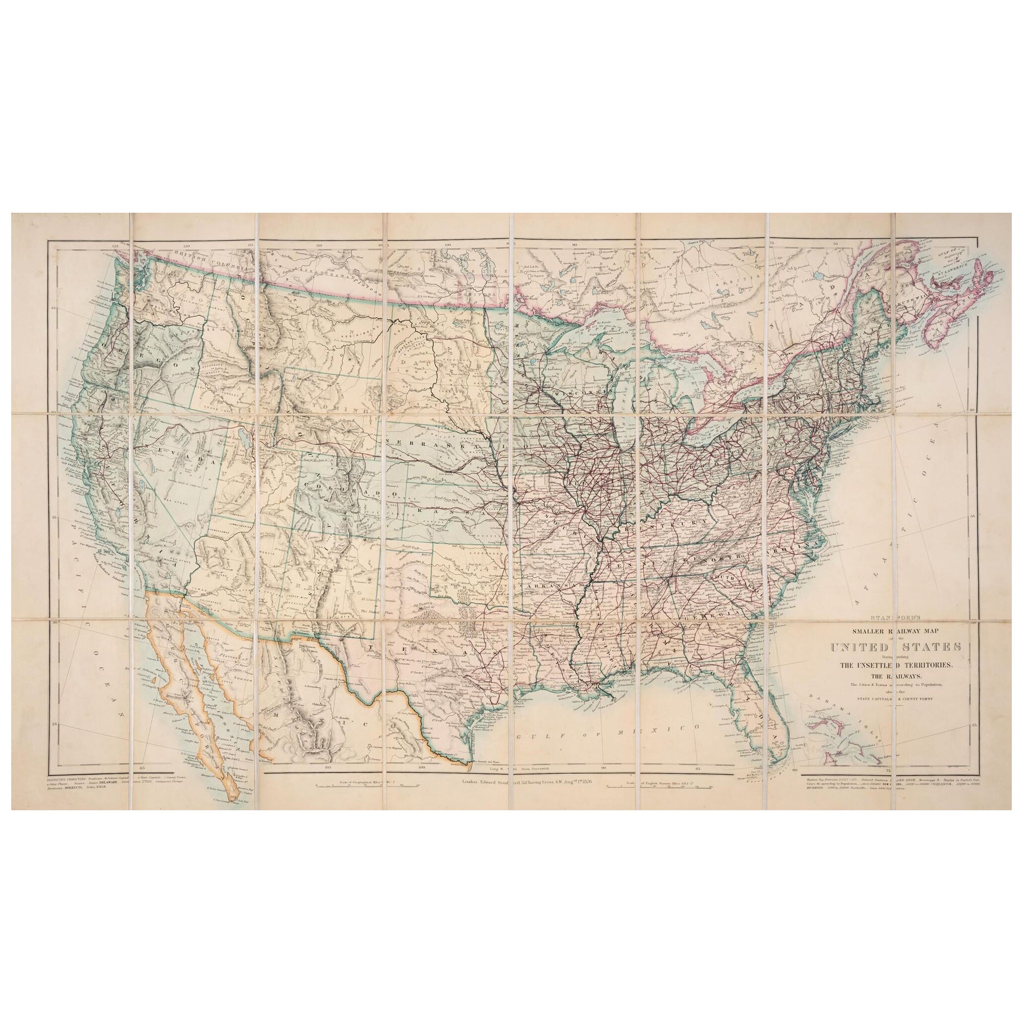
Mappa degli Stati Uniti del 1876: Con i dettagli delle ferrovie e dei territori non colonizzati
Mappa ferroviaria ridotta degli Stati Uniti di Stanford, 1876
Questa mappa originale del 1876, intitolata "Stanford's Smaller Railway Map of the United States Distinguishing the Uns...
Categoria
Di antiquariato/d’epoca, Anni 1870, Mappe
Materiali
Carta
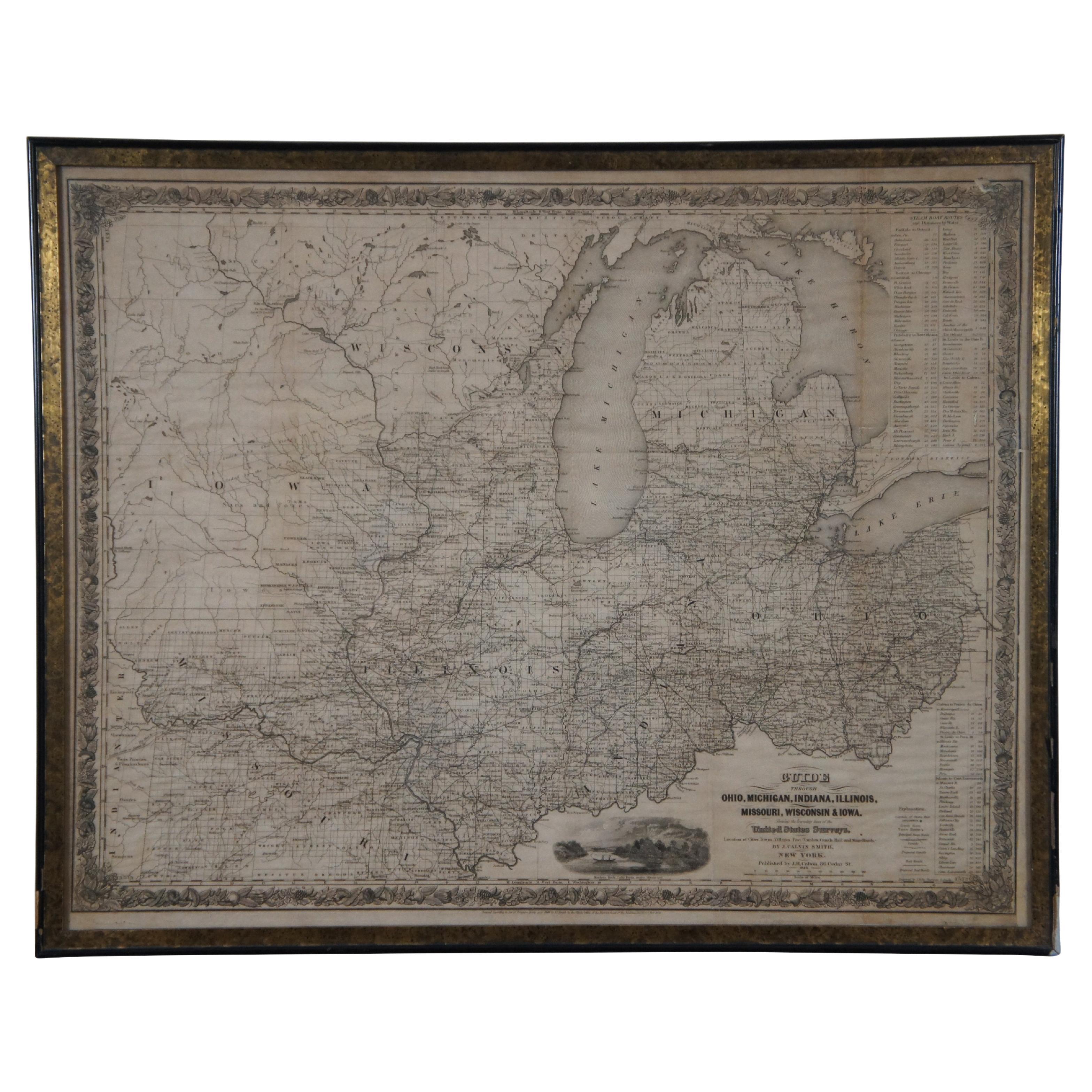
Antico 1844 J Calvin Smith JH Colton Midwest United States Survey Map 27"
Di J.H. Colton
Antica mappa incorniciata in bianco e nero di sette stati americani del Midwest. Guida attraverso Ohio, Michigan, Indiana, Illinois, Missouri, Wisconsin e Iowa. Mostra le linee dei c...
Categoria
Di antiquariato/d’epoca, Anni 1840, Mappe
Materiali
Carta

820 € Prezzo promozionale
20% in meno
Mappa ornata degli Stati Uniti del 1850: Con punti di riferimento iconici e torrette
Mappa ornata degli Stati Uniti del 1850: Con punti di riferimento iconici e ritratti storici
Questa mappa decorativa degli Stati Uniti del XIX secolo, creata da J. Rapkin e pubbli...
Categoria
Di antiquariato/d’epoca, Anni 1850, Mappe
Materiali
Carta
Mappa antica originale degli Stati Uniti, Grattan and Gilbert, 1843
Grande mappa degli Stati Uniti
Disegnato e inciso da Archer
Pubblicato da Grattan e Gilbert. 1843
Colore originale
Senza cornice.
Categoria
Di antiquariato/d’epoca, Anni 1840, Inglese, Mappe
Materiali
Carta
